Sojourner wheel base and the ramp off Pathfinder |

  |
Sojourner wheel base and the ramp off Pathfinder |
 Oct 14 2008, 11:41 PM Oct 14 2008, 11:41 PM
Post
#1
|
|
 Member  Group: Members Posts: 753 Joined: 23-October 04 From: Greensboro, NC USA Member No.: 103 |
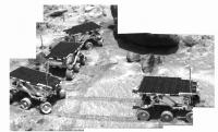
I had the afternoon off today, so I popped over to the National Air & Space Museum's Udvar-Hazy Center. I spent some time looking at their Mars Pathfinder display. Their Pathfinder is an engineering duplicate of the lander, and the Sojourner is "a nonworking model built by JPL for the NASM." One thing that struck me was that the ramps for Sojourner looked too narrow. It looks like there are metal guides that are about the same distance apart as the inside wheelbase dimensions, so they could act as a guide for Sojourner's wheels. However, there didn't seem to be enough width of material outboard of those guides on which Sojourner's wheels could safely travel or be supported. The only other thing I can figure is that the dimensions on these two display items don't match up.
Does anyone recall how that worked? Here's a photo I snapped today, perhaps you can see what I mean. Sojourner model on Pathfinder -------------------- Jonathan Ward
Manning the LCC at http://www.apollolaunchcontrol.com |
 |
 
|
|
Oct 15 2008, 01:30 AM
Post
#2
|
|
|
Solar System Cartographer Group: Members Posts: 10151 Joined: 5-April 05 From: Canada Member No.: 227 |
http://mars.jpl.nasa.gov/MPF/ops/80911_full.jpg
From the tracks at the base of the ramp, this looks about the same as the museum display. Phil -------------------- ... because the Solar System ain't gonna map itself.
Also to be found posting similar content on https://mastodon.social/@PhilStooke Maps for download (free PD: https://upload.wikimedia.org/wikipedia/comm...Cartography.pdf NOTE: everything created by me which I post on UMSF is considered to be in the public domain (NOT CC, public domain) |
|
|
|
|
Oct 16 2008, 02:00 AM
Post
#3
|
|
|
Member Group: Members Posts: 753 Joined: 23-October 04 From: Greensboro, NC USA Member No.: 103 |
I guess the ramp material is stiffer than it looks!
Found the movie of the roll down the ramp - it does indeed use the metal guides and roll the wheels outside of them - that looked like a tougher steering challenge than I remember! Sojourner rolls down the ramp Looking at my image from the museum, it appears that the guide on the right side of the picture extends farther back onto the lander deck than the one on the left. That would have served to align the wheels and drive path as Sojourner first began moving. -------------------- Jonathan Ward
Manning the LCC at http://www.apollolaunchcontrol.com |
|
|
|
|
Oct 16 2008, 03:13 AM
Post
#4
|
|
|
Senior Member Group: Members Posts: 2511 Joined: 13-September 05 Member No.: 497 |
http://trs-new.jpl.nasa.gov/dspace/handle/2014/23848 may be of interest.
-------------------- Disclaimer: This post is based on public information only. Any opinions are my own.
|
|
|
|
|
Oct 16 2008, 09:25 PM
Post
#5
|
|
|
Member Group: Members Posts: 753 Joined: 23-October 04 From: Greensboro, NC USA Member No.: 103 |
Super, thanks for the link!
-------------------- Jonathan Ward
Manning the LCC at http://www.apollolaunchcontrol.com |
|
|
|
|
Aug 10 2009, 01:27 AM
Post
#6
|
|||
|
Solar System Cartographer Group: Members Posts: 10151 Joined: 5-April 05 From: Canada Member No.: 227 |
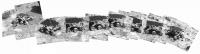
Returning to an older Sojourner thread... there's still lots of good stuff to do with that mission, and the images are available in the Planetary Image Atlas. I'm trying to reconstruct the rover route map. I hope nobody reading this was responsible for making the mission maps - cuz they are awful! Well, the polar one with tracks all around the lander looks good, but it's a simplification. and the other map that frequently made it into journals has all sorts of gaps caused by improved estimates of location from the end of one day to the start of the next.
Well, I guess I'll be cleaning it up myself. As a start I'm assembling daily composites of IMP rover documentation images like these. Sol 12 and Sol 23. Phil
-------------------- ... because the Solar System ain't gonna map itself.
Also to be found posting similar content on https://mastodon.social/@PhilStooke Maps for download (free PD: https://upload.wikimedia.org/wikipedia/comm...Cartography.pdf NOTE: everything created by me which I post on UMSF is considered to be in the public domain (NOT CC, public domain) |
||
|
|
|
||
|
Aug 10 2009, 01:57 AM
Post
#7
|
|
 Interplanetary Dumpster Diver Group: Admin Posts: 4404 Joined: 17-February 04 From: Powell, TN Member No.: 33 |
This is really cool! That reminds me, I am two thirds of the way though the rover black and white images, after which I will have the entire set of rover images done.
-------------------- |
|
|
|
|
Aug 18 2009, 04:39 PM
Post
#8
|
||
|
Solar System Cartographer Group: Members Posts: 10151 Joined: 5-April 05 From: Canada Member No.: 227 |
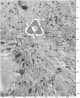
I've been working on a new map of the Pathfinder site. It's always hard to create a photomap from reprojected surface images, but here the spatial control is the HiRISE image, making it a bit more reliable than the contemporary mission maps.
Phil
-------------------- ... because the Solar System ain't gonna map itself.
Also to be found posting similar content on https://mastodon.social/@PhilStooke Maps for download (free PD: https://upload.wikimedia.org/wikipedia/comm...Cartography.pdf NOTE: everything created by me which I post on UMSF is considered to be in the public domain (NOT CC, public domain) |
|
|
|
|
|
|
Aug 18 2009, 07:52 PM
Post
#9
|
|
|
Interplanetary Dumpster Diver Group: Admin Posts: 4404 Joined: 17-February 04 From: Powell, TN Member No.: 33 |
You might want to use the Sojourner panorama from Sol 76 to fill in the area behind the rock garden.
-------------------- |
|
|
|
|
Aug 18 2009, 08:15 PM
Post
#10
|
|
|
Solar System Cartographer Group: Members Posts: 10151 Joined: 5-April 05 From: Canada Member No.: 227 |
I'm considering it, but much of it lies outside my area.
Phil -------------------- ... because the Solar System ain't gonna map itself.
Also to be found posting similar content on https://mastodon.social/@PhilStooke Maps for download (free PD: https://upload.wikimedia.org/wikipedia/comm...Cartography.pdf NOTE: everything created by me which I post on UMSF is considered to be in the public domain (NOT CC, public domain) |
|
|
|
|
Aug 26 2009, 08:47 PM
Post
#11
|
||
|
Solar System Cartographer Group: Members Posts: 10151 Joined: 5-April 05 From: Canada Member No.: 227 |
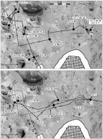
This is a part of the Sojourner route map I have compiled for my Mars Atlas. The background is from the Pathfinder panorama, projected as close as I can get it to fit the geometry of the HiRISE image. The routes, overnight stops and experiment locations are indicated. Labels like S2, A4, W3 refer to the various experiments which will be described in the text.
Phil
-------------------- ... because the Solar System ain't gonna map itself.
Also to be found posting similar content on https://mastodon.social/@PhilStooke Maps for download (free PD: https://upload.wikimedia.org/wikipedia/comm...Cartography.pdf NOTE: everything created by me which I post on UMSF is considered to be in the public domain (NOT CC, public domain) |
|
|
|
|
|
|
Aug 29 2009, 01:25 PM
Post
#12
|
|
 Senior Member Group: Members Posts: 1084 Joined: 19-February 05 From: Close to Meudon Observatory in France Member No.: 172 |
QUOTE (ilbasso @ Oct 15 2008, 01:41 AM)  Does anyone recall how that worked? I was at the NASM in July 1996 for the 1997 Internet Pathfinder rehearsal when this exhibit was set-up by the JPL Mars Outreach. When the model was ordered in 1995 by the Mars Outreach, the flight lander was still under construction at JPL by the engineers and JPL was then unable to give the very final specs to the model builder by lack of time from the engineering team : the engineers were under tremendous work pressure to meet the mission calendar (it was indeed s a small team). This is why you see such small differences between the Sojourner wheels and the lander ramps widths... (remember that the Sojourner rover was only fully integrated in January 1996 with the Pathfinder lander...). Well, the lander is not that perfect but it proved to be an useful educational tool to explain how we were coming back to Mars. Eventually it helped create a new "Mars spirit" among the people that helped fund more missions... 
|
|
|
|
|

|
Lo-Fi Version | Time is now: 26th April 2024 - 01:30 AM |
|
RULES AND GUIDELINES Please read the Forum Rules and Guidelines before posting. IMAGE COPYRIGHT |
OPINIONS AND MODERATION Opinions expressed on UnmannedSpaceflight.com are those of the individual posters and do not necessarily reflect the opinions of UnmannedSpaceflight.com or The Planetary Society. The all-volunteer UnmannedSpaceflight.com moderation team is wholly independent of The Planetary Society. The Planetary Society has no influence over decisions made by the UnmannedSpaceflight.com moderators. |
SUPPORT THE FORUM Unmannedspaceflight.com is funded by the Planetary Society. Please consider supporting our work and many other projects by donating to the Society or becoming a member. |
|