Spirit Route Map, Small and Large Scales |

  |
Spirit Route Map, Small and Large Scales |
 Jan 4 2006, 11:28 PM Jan 4 2006, 11:28 PM
Post
#211
|
|
|
Merciless Robot  Group: Admin Posts: 8783 Joined: 8-December 05 From: Los Angeles Member No.: 602 |
How about Rectangle Ridge, for the formation's overhead appearance?
-------------------- A few will take this knowledge and use this power of a dream realized as a force for change, an impetus for further discovery to make less ancient dreams real.
|
 |
 
|
|
Jan 4 2006, 11:30 PM
Post
#212
|
|
 Senior Member Group: Members Posts: 1229 Joined: 24-December 05 From: The blue one in between the yellow and red ones. Member No.: 618 |
QUOTE (akuo @ Jan 4 2006, 01:23 PM) No! It's McCool hill! See general's post 5 articles back :-)   JEEEEZZ! Never mind, guys. Just leave a trail of breadcrumbs, and I'll follow. JEEEEZZ! Never mind, guys. Just leave a trail of breadcrumbs, and I'll follow.
-------------------- My Grandpa goes to Mars every day and all I get are these lousy T-shirts!
|
|
|
|
|
Jan 4 2006, 11:32 PM
Post
#213
|
|
|
Member Group: Members Posts: 470 Joined: 24-March 04 From: Finland Member No.: 63 |
QUOTE (Shaka @ Jan 4 2006, 11:30 PM) JEEEEZZ! Never mind, guys. Just leave a trail of breadcrumbs, and I'll follow.Just to make it clearer, the direction towards McCool hill is south in Alan's fine picture. -------------------- Antti Kuosmanen
|
|
|
|
|
Jan 5 2006, 01:53 AM
Post
#214
|
|
 Senior Member Group: Moderator Posts: 2262 Joined: 9-February 04 From: Melbourne - Oz Member No.: 16 |
QUOTE (akuo @ Jan 5 2006, 10:32 AM) And to hopefully clear things up even more. The edge of the feature the Shaka put a ? on is the rise going off the left edge of Alans picture. -------------------- |
|
|
|
|
Jan 5 2006, 10:26 AM
Post
#215
|
||
|
Senior Member Group: Moderator Posts: 4279 Joined: 19-April 05 From: .br at .es Member No.: 253 |
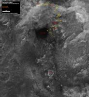
Route map updated up to sol 713.
I've changed the background image to the new cProto picture of the Hills released on Jan 03. It is more detailed but I personally see some drawbacks on its use here. First, bigger resolution means bigger file size or heavier compression. Second, it seems this pic was taken almost at noon because it has much smaller shadows then the previous image. The result is that the "3D effect" which was previously visible has been lost. Anybody can try to identify Miami and Comanche on the new picture; it's HARD, if even possible... Comments are welcome. 
|
|
|
|
|
|
|
Jan 5 2006, 10:38 AM
Post
#216
|
||
|
Founder Group: Chairman Posts: 14431 Joined: 8-February 04 Member No.: 1 |
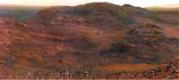
I've tried to compare Alan-is-Lost with Tesh-Map
It doesnt look like much, but it really helped me put the local geography into some sort of context. Doug
Attached thumbnail(s)
|
|
|
|
|
|
|
Jan 5 2006, 05:09 PM
Post
#217
|
|
|
Member Group: Members Posts: 236 Joined: 21-June 05 Member No.: 417 |
Beautiful new traverse maps:
http://marsrovers.jpl.nasa.gov/mission/tm-spirit/index.html |
|
|
|
|
Jan 5 2006, 05:12 PM
Post
#218
|
|
|
Founder Group: Chairman Posts: 14431 Joined: 8-February 04 Member No.: 1 |

|
|
|
|
|
Jan 5 2006, 05:21 PM
Post
#219
|
|
 Special Cookie Group: Members Posts: 2168 Joined: 6-April 05 From: Sintra | Portugal Member No.: 228 |
Double quoting Doug...
-------------------- "Ride, boldly ride," The shade replied, "If you seek for Eldorado!"
Edgar Alan Poe |
|
|
|
|
Jan 5 2006, 05:23 PM
Post
#220
|
|
 Member Group: Members Posts: 699 Joined: 3-December 04 From: Boulder, Colorado, USA Member No.: 117 |
QUOTE (djellison @ Jan 5 2006, 10:38 AM) I've tried to compare Alan-is-Lost with Tesh-Map It doesnt look like much, but it really helped me put the local geography into some sort of context. Doug Outstanding- that's the clearest tie-in between the orbital and rover views that I've seen. Everything is clear now... |
|
|
|
|
Jan 5 2006, 05:40 PM
Post
#221
|
|
|
Founder Group: Chairman Posts: 14431 Joined: 8-February 04 Member No.: 1 |
I've sent a polite email to Dr Li ( he of MER Mapping fame, and the head of the dept. that produced those most recent, amazing maps ) and asked if he might be able to release an elevation map or DEM so that I could do some perspective views and animations of the area. If we're lucky, I might be able to do something like the old perspective views I did - http://www.unmannedspaceflight.com/doug_images/elev_1.jpg - but much much MUCH better
Doug |
|
|
|
|
Jan 5 2006, 06:02 PM
Post
#222
|
|
 Member Group: Members Posts: 648 Joined: 9-May 05 From: Subotica Member No.: 384 |
QUOTE (djellison @ Jan 5 2006, 08:40 PM) ...If we're lucky, I might be able to do something like the old perspective views I did - http://www.unmannedspaceflight.com/doug_images/elev_1.jpg - but much much MUCH better Doug Yeah I remember those maps...they were wonderful... But this map does not show where Spirit is in relation to the Columbia Hills  ...just the height of the area.... ...just the height of the area....Maybe they should add another map....old ways are sometimes better... -------------------- The scientist does not study nature because it is useful; he studies it because he delights in it, and he delights in it because it is beautiful.
Jules H. Poincare My "Astrophotos" gallery on flickr... |
|
|
|
|
Jan 5 2006, 08:03 PM
Post
#223
|
|
|
Senior Member Group: Members Posts: 1636 Joined: 9-May 05 From: Lima, Peru Member No.: 385 |
Somewhat close, it is a bi-dimensional map. I am copying it the updated Jan 5 Spirit route map with altitude reference.
 Southwest is of the lowest altitude and the Southeast is of the highest altitude. I think that Home Plate is still out of range in that map, still further south. Rodolfo |
|
|
|
|
Jan 5 2006, 10:05 PM
Post
#224
|
||
 Senior Member Group: Members Posts: 1887 Joined: 20-November 04 From: Iowa Member No.: 110 |
another drive day
|
|
|
|
|
|
|
Jan 5 2006, 10:20 PM
Post
#225
|
|
 Member Group: Members Posts: 531 Joined: 24-August 05 Member No.: 471 |
Alan, is this image exaggerated version?
-------------------- - blue_scape / Nico -
|
|
|
|
|

|
Lo-Fi Version | Time is now: 19th April 2024 - 07:35 AM |
|
RULES AND GUIDELINES Please read the Forum Rules and Guidelines before posting. IMAGE COPYRIGHT |
OPINIONS AND MODERATION Opinions expressed on UnmannedSpaceflight.com are those of the individual posters and do not necessarily reflect the opinions of UnmannedSpaceflight.com or The Planetary Society. The all-volunteer UnmannedSpaceflight.com moderation team is wholly independent of The Planetary Society. The Planetary Society has no influence over decisions made by the UnmannedSpaceflight.com moderators. |
SUPPORT THE FORUM Unmannedspaceflight.com is funded by the Planetary Society. Please consider supporting our work and many other projects by donating to the Society or becoming a member. |
|