Titan's changing lakes |

  |
Titan's changing lakes |
 Jan 29 2009, 07:22 PM Jan 29 2009, 07:22 PM
Post
#1
|
|
|
Senior Member  Group: Members Posts: 3516 Joined: 4-November 05 From: North Wales Member No.: 542 |
Today's big news?
http://ciclops.org/view/5471/CASSINI_FINDS...ILL_TITAN_LAKES Changes in the south polar region were announced late last year. Is there more to this story now?? |
 |
 
|
|
Jan 29 2009, 07:32 PM
Post
#2
|
|
|
Senior Member Group: Members Posts: 3516 Joined: 4-November 05 From: North Wales Member No.: 542 |
|
|
|
|
|
Jan 29 2009, 07:34 PM
Post
#3
|
|
 Senior Member Group: Moderator Posts: 3242 Joined: 11-February 04 From: Tucson, AZ Member No.: 23 |
Here are some the associated graphics:
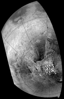
http://photojournal.jpl.nasa.gov/catalog/PIA11147 This shows the changes that we are highlighting in this paper. Basically, between July 2004 and June 2005, a 31,000 sq. km area of the south polar region of Titan went from being nondescript to being a patchwork of dark features. These darkening is thought to result from the deposition of liquid methane and dark sediment in this area. The mostly likely mechanism for this change is that a major rainstorm in the 11 months between the observations rained out, filling a low-land region, a playa, within a shallow layer of liquid methane. The most likely storm to cause this was a huge storm system seen from the ground and by ISS in early October 2004. Based on ISS observations, the most intense part of the storm (as determined by the brightest part of the storm which likely represents the area with the greatest cloud heights) on October 8, 2004 was directly over this region. http://photojournal.jpl.nasa.gov/catalog/PIA11146 This is the labeled version of my August 2008 map. Of particular interest in this map is the polar coverage we are now achieving. In the north polar region, we see a field of dark spots on the leading hemisphere and several large methane seas (Kraken Mare, Ligeia Mare, and Punga Mare). These features were previously seen by RADAR and likely represent lakes. The number of dark features seen in the south polar region exceed those seen by RADAR in its swaths of the region, suggesting that some have dried up since 2005. -------------------- &@^^!% Jim! I'm a geologist, not a physicist!
The Gish Bar Times - A Blog all about Jupiter's Moon Io |
|
|
|
|
Jan 29 2009, 07:35 PM
Post
#4
|
|
|
Senior Member Group: Moderator Posts: 3242 Joined: 11-February 04 From: Tucson, AZ Member No.: 23 |
QUOTE (ngunn @ Jan 29 2009, 12:22 PM)  Changes in the south polar region were announced late last year. Is there more to this story now?? The paper was published on GRL website and was "in press" starting in early December. This press release is going in conjunction with that paper actually being published in the print version of the journal. -------------------- &@^^!% Jim! I'm a geologist, not a physicist!
The Gish Bar Times - A Blog all about Jupiter's Moon Io |
|
|
|
|
Jan 29 2009, 07:45 PM
Post
#5
|
|
|
Senior Member Group: Members Posts: 3516 Joined: 4-November 05 From: North Wales Member No.: 542 |
That's brilliant, thanks VP.
|
|
|
|
|
Jan 29 2009, 09:11 PM
Post
#6
|
|
 Member Group: Members Posts: 131 Joined: 30-August 06 From: Moscow, Idaho Member No.: 1086 |
I actually much prefer that these press releases coincide with actual scientific papers; it increases the signal-to-noise. Any damned idiot can put out a press release, but without a peer-reviewed paper to back it up it's just gum-flapping. This is the first time that this discovery has been announced. You here of the cognescenti know of it from Dr. Turtle's DPS talk, but this is the first public release.
The ISS team did this one right, and by the book, so don't give them crap for it! - VIMS Jason |
|
|
|
|
Jan 30 2009, 02:14 AM
Post
#7
|
|
|
Senior Member Group: Members Posts: 3516 Joined: 4-November 05 From: North Wales Member No.: 542 |
QUOTE (Jason W Barnes @ Jan 29 2009, 09:11 PM) The ISS team did this one right, and by the book, so don't give them crap for it! No-one's doing that - certainly not me. I'm 100 percent delighted with what they (and all the other instrument teams) do. The images and map associated with that release are new to me. If they were posted here before, I missed them. Until now I didn't know exactly where the newly 'flooded playa' was, and I found the comments in the article most interesting. Not so long ago there were people here (not the mission scientists) saying that Titan doesn't receive enough solar energy to empty and fill the lakes on a seasonal basis. I'm hoping 2009 brings us more, and that this is just the beginning of Cassini's record of Titan's surface changing with the seasons. While you're on the line - can you shed any more light on the question of using the ISS polarisers to look for sky reflections in the lakes? There probably are reasons why it isn't worth trying but I can't discover them. |
|
|
|
|
Jan 30 2009, 05:33 PM
Post
#8
|
|
|
Member Group: Members Posts: 131 Joined: 30-August 06 From: Moscow, Idaho Member No.: 1086 |
QUOTE (ngunn @ Jan 29 2009, 08:14 PM) While you're on the line - can you shed any more light on the question of using the ISS polarisers to look for sky reflections in the lakes? There probably are reasons why it isn't worth trying but I can't discover them. Well, since the lakes are at the poles the incidence angle is always going to be 70 degrees or higher. Therefore to see a specular reflection, you'll need to look with emission angle of 70 degrees or higher as well. As you know from processing the ISS data, the empirical atmospheric correction that they do does not produce reliable surface photometry this close to the limb. Look at Mezzoramia in the Turtle et al. paper -- the brightness looks quite different between these two flybys, when there's every reason to think that it hasn't actually changed at all. Another reason is that you'd need a very specialized encounter geometry in order to be in position to see the specular reflection. I can't speak for ISS. But as for VIMS, we've made the decision that if we were in such a geometry, we'd rather be looking straight down at the ground with 0 emission angle, as that would mean new territory at fine resolution. This type of observation may have been rendered moot by the T49 RADAR altimetry pass -- we'll have to wait until that's been released to find out. Hope this helps, - VIMS Jason |
|
|
|
|
Jan 30 2009, 08:16 PM
Post
#9
|
|
|
Senior Member Group: Members Posts: 3516 Joined: 4-November 05 From: North Wales Member No.: 542 |
That is indeed most helpful. Although I'm still not clear why the direction of the sun should be a constraint if one is only looking for a reflection of the hazy sky, I can well appreciate how the other difficulties might mount up.
What is the RADAR turning up I wonder? Like many others I await that too with eager anticipation. Patience is needed there I know, but the upcoming flyby will provide plenty of excitement in near-ish real time. Seatbelts fastened, a quick wave at the lake and in we go! |
|
|
|
|
Feb 2 2009, 10:57 AM
Post
#10
|
|
|
Senior Member Group: Members Posts: 1276 Joined: 25-November 04 Member No.: 114 |
Does anyone have a radar swath overlay-ed of the south pole?
Have lost mine and have been unable to locate it. |
|
|
|
|
Feb 2 2009, 03:15 PM
Post
#11
|
||
|
Member Group: Members Posts: 708 Joined: 1-April 08 From: Minnesota ! Member No.: 4081 |
QUOTE (Decepticon @ Feb 2 2009, 04:57 AM) Does anyone have a radar swath overlay-ed of the south pole? Have lost mine and have been unable to locate it. Check post # 29 http://www.unmannedspaceflight.com/index.p...st&p=107096 by Olvegg in the T39 flyby topic; a portion of that SAR included the S Pole. Hmm... looks like those new lakes are present on the background image in that post (but not necessarily in the swath path). In the animation below the S. Polar terrain is shown before and after the October 2004 storms along with the approximate location of the T39 SAR swath.
|
|
|
|
|
|
|
Feb 4 2009, 03:36 PM
Post
#12
|
|
 Member Group: Members Posts: 613 Joined: 23-February 07 From: Occasionally in Columbia, MD Member No.: 1764 |
QUOTE (ngunn @ Jan 30 2009, 03:16 PM) What is the RADAR turning up I wonder? Like many others I await that too with eager anticipation. Patience is needed there I know LPSC abstracts will be out soon - there will be something for you there |
|
|
|
|
Feb 4 2009, 09:11 PM
Post
#13
|
|
|
Senior Member Group: Members Posts: 3516 Joined: 4-November 05 From: North Wales Member No.: 542 |
Excellent!!
|
|
|
|
|
Feb 5 2009, 12:37 AM
Post
#14
|
|
|
Merciless Robot Group: Admin Posts: 8785 Joined: 8-December 05 From: Los Angeles Member No.: 602 |
Oh, goodygoodygoody...Santa Ralph hints that a bit of Christmas is coming early this year!

-------------------- A few will take this knowledge and use this power of a dream realized as a force for change, an impetus for further discovery to make less ancient dreams real.
|
|
|
|
|
Feb 7 2009, 04:48 PM
Post
#15
|
|
 Senior Member Group: Moderator Posts: 2785 Joined: 10-November 06 From: Pasadena, CA Member No.: 1345 |
Bam! There it is!
Lorenz et al. LPSC (2009) Abstract 1990 "ONTARIO LACUS : BRILLIANT OBSERVATIONS OF A TITAN LAKE BY THE CASSINI RADAR ALTIMETER." Available here: http://www.lpi.usra.edu/meetings/lpsc2009/pdf/1990.pdf Ontario Lacus is flat, and deep, no bottom echo by RADAR. -------------------- Some higher resolution images available at my photostream: http://www.flickr.com/photos/31678681@N07/
|
|
|
|
|

|
Lo-Fi Version | Time is now: 26th September 2024 - 07:23 PM |
|
RULES AND GUIDELINES Please read the Forum Rules and Guidelines before posting. IMAGE COPYRIGHT |
OPINIONS AND MODERATION Opinions expressed on UnmannedSpaceflight.com are those of the individual posters and do not necessarily reflect the opinions of UnmannedSpaceflight.com or The Planetary Society. The all-volunteer UnmannedSpaceflight.com moderation team is wholly independent of The Planetary Society. The Planetary Society has no influence over decisions made by the UnmannedSpaceflight.com moderators. |
SUPPORT THE FORUM Unmannedspaceflight.com is funded by the Planetary Society. Please consider supporting our work and many other projects by donating to the Society or becoming a member. |
|