Roving into the Sulfate Hills, Sol 3200-3387, 6 Aug 2021-16 Feb 2022 |

  |
Roving into the Sulfate Hills, Sol 3200-3387, 6 Aug 2021-16 Feb 2022 |
 Aug 12 2021, 04:00 AM Aug 12 2021, 04:00 AM
Post
#16
|
||
|
Solar System Cartographer  Group: Members Posts: 10146 Joined: 5-April 05 From: Canada Member No.: 227 |
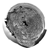
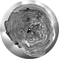
The sol 3203 panorama kindly provided by Jan, in circular form. A very rough landscape!
Phil
-------------------- ... because the Solar System ain't gonna map itself.
Also to be found posting similar content on https://mastodon.social/@PhilStooke NOTE: everything created by me which I post on UMSF is considered to be in the public domain (NOT CC, public domain) |
|
 |
 
|
|
|
Aug 12 2021, 05:37 AM
Post
#17
|
||
|
Founder Group: Chairman Posts: 14431 Joined: 8-February 04 Member No.: 1 |
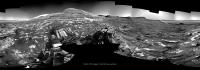
I tried taking one of the auto-generated Navcam mosaics - turning it into philovision and then an HDR stretch to even out some of the lighting for the Sol 3204 mosaic - came out pretty well.
Attached thumbnail(s)
|
|
|
|
|
|
|
Aug 12 2021, 06:21 AM
Post
#18
|
|
|
Solar System Cartographer Group: Members Posts: 10146 Joined: 5-April 05 From: Canada Member No.: 227 |
My work here is done.
Phil -------------------- ... because the Solar System ain't gonna map itself.
Also to be found posting similar content on https://mastodon.social/@PhilStooke NOTE: everything created by me which I post on UMSF is considered to be in the public domain (NOT CC, public domain) |
|
|
|
|
Aug 12 2021, 11:28 AM
Post
#19
|
||
|
Senior Member Group: Members Posts: 2817 Joined: 22-April 05 From: Ridderkerk, Netherlands Member No.: 353 |
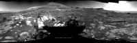
Here is new work Phil.
The Navcam R view on Sol 3204. Jan van Driel
|
|
|
|
|
|
|
Aug 12 2021, 03:20 PM
Post
#20
|
|
|
Founder Group: Chairman Posts: 14431 Joined: 8-February 04 Member No.: 1 |
For those wondering - rough (but not JPGd) post drive imaging mosaics get posted here - https://mars.nasa.gov/msl/multimedia/mosaics/ - automagically by a downlink script that generates them after downlink. If you see multiple mosaics for a given sol, that's subsequent downlink passes sending more data to fill in more blanks. That's what I used to make that phil-o-vision from 2 posts ago

|
|
|
|
|
Aug 12 2021, 07:30 PM
Post
#21
|
||
|
Senior Member Group: Members Posts: 2817 Joined: 22-April 05 From: Ridderkerk, Netherlands Member No.: 353 |
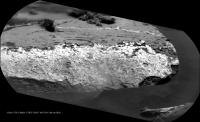
Chemcam view on Sol 3204.
Jan van Driel
|
|
|
|
|
|
|
Aug 13 2021, 06:29 AM
Post
#22
|
||
|
Solar System Cartographer Group: Members Posts: 10146 Joined: 5-April 05 From: Canada Member No.: 227 |
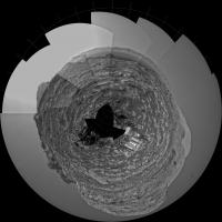
Jan's sol 3204 panorama in circular form.
Phil
-------------------- ... because the Solar System ain't gonna map itself.
Also to be found posting similar content on https://mastodon.social/@PhilStooke NOTE: everything created by me which I post on UMSF is considered to be in the public domain (NOT CC, public domain) |
|
|
|
|
|
|
Aug 13 2021, 04:05 PM
Post
#23
|
|
|
Solar System Cartographer Group: Members Posts: 10146 Joined: 5-April 05 From: Canada Member No.: 227 |
Sol 3206 - we had a c. 5 m drive northwest (maybe for an interesting target?) - map update after Grandad duty.
Phil -------------------- ... because the Solar System ain't gonna map itself.
Also to be found posting similar content on https://mastodon.social/@PhilStooke NOTE: everything created by me which I post on UMSF is considered to be in the public domain (NOT CC, public domain) |
|
|
|
|
Aug 13 2021, 07:35 PM
Post
#24
|
|
|
Member Group: Members Posts: 923 Joined: 10-November 15 Member No.: 7837 |
QUOTE (djellison @ Aug 12 2021, 04:20 PM)  For those wondering - rough (but not JPGd) post drive imaging mosaics get posted here - https://mars.nasa.gov/msl/multimedia/mosaics/ - automagically by a downlink script that generates them after downlink. If you see multiple mosaics for a given sol, that's subsequent downlink passes sending more data to fill in more blanks. That's what I used to make that phil-o-vision from 2 posts ago Oh to get those unstretched images as png's on the day they are downlinked... maybe as a 10 year anniversary gift? -------------------- |
|
|
|
|
Aug 13 2021, 08:18 PM
Post
#25
|
|
|
Founder Group: Chairman Posts: 14431 Joined: 8-February 04 Member No.: 1 |
This late in the mission - when budgets for refactoring the website to receive them - pretty unlikely. But I'll try and ask around.
|
|
|
|
|
Aug 13 2021, 09:27 PM
Post
#26
|
||
|
Senior Member Group: Members Posts: 2817 Joined: 22-April 05 From: Ridderkerk, Netherlands Member No.: 353 |
The Navcam R view on Sol 3206.
Jan van Driel
|
|
|
|
|
|
|
Aug 15 2021, 05:27 AM
Post
#27
|
||
|
Founder Group: Chairman Posts: 14431 Joined: 8-February 04 Member No.: 1 |
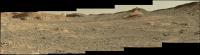
Sol 3206 Mastcam Drive Direction
Attached thumbnail(s)
|
|
|
|
|
|
|
Aug 15 2021, 05:39 AM
Post
#28
|
||
|
Founder Group: Chairman Posts: 14431 Joined: 8-February 04 Member No.: 1 |
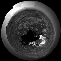
And post drive imaging in Phil-O-Vision
Attached thumbnail(s)
|
|
|
|
|
|
|
Aug 15 2021, 09:53 AM
Post
#29
|
|
|
Member Group: Members Posts: 362 Joined: 13-April 06 From: Malta Member No.: 741 |
QUOTE (Saturns Moon Titan @ Aug 11 2021, 09:24 PM) [attachment=49090:ped_climb.JPG] And we have almost arrived at the pediment already! The resistant capstone at the top of the cliff in front of us is indeed the Greenheugh pediment I have overlaid the MSAR_10 route (the most recent strategic route) to show roughly where the team probably intends to ascend up onto the pediment. From the looks of the planned traverse, the rover will follow this cliff uphill, squeezing through a narrow passage and then ascending a ramp. However, before all that I expect they'll want to drill nearby to where we are now, to document the chemistry of the rocks directly underneath the pediment. Once we're ontop, the view will be very special. Looks like they plan on sending the rover towards that big ridge that runs down the middle of it - my understanding is that there's debate over whether the Greenheugh pediment represents just aeolian sandstones, basically a lateral continuation of the stimson formation (remember the buttes all those years ago?), alternatively it might be an alluvial fan. It certainly resembles a fan in shape and that big ridge running down the middle could be an inverted channel. This is why the mission geologists want to send the rover there, to check which theory's true!Some Hong Kong University scientists in a recent paper have suggested that all rock layers studied by Cuuriosity so far except for the Bradbury formation seem to be wind swept deposits rather than lacustrine. Any ideas? |
|
|
|
|
Aug 15 2021, 11:48 AM
Post
#30
|
||
 Member Group: Members Posts: 684 Joined: 24-July 15 Member No.: 7619 |
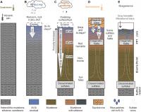
QUOTE (Julius @ Aug 15 2021, 10:53 AM) Some Hong Kong University scientists in a recent paper have suggested that all rock layers studied by Cuuriosity so far except for the Bradbury formation seem to be wind swept deposits rather than lacustrine. Any ideas? FYI Intense subaerial weathering of eolian sediments in Gale crater, Mars Jiacheng Liu1,2, Joseph R. Michalski1,2, and Mei-Fu Zhou1,3 Science Advances 06 Aug 2021:Vol. 7, no. 32, eabh2687 DOI: 10.1126/sciadv.abh2687 https://advances.sciencemag.org/content/7/32/eabh2687.full Figure #6 from the paper summarizes their theory
Attached thumbnail(s)
|
|
|
|
|
|
|

|
Lo-Fi Version | Time is now: 19th April 2024 - 04:49 AM |
|
RULES AND GUIDELINES Please read the Forum Rules and Guidelines before posting. IMAGE COPYRIGHT |
OPINIONS AND MODERATION Opinions expressed on UnmannedSpaceflight.com are those of the individual posters and do not necessarily reflect the opinions of UnmannedSpaceflight.com or The Planetary Society. The all-volunteer UnmannedSpaceflight.com moderation team is wholly independent of The Planetary Society. The Planetary Society has no influence over decisions made by the UnmannedSpaceflight.com moderators. |
SUPPORT THE FORUM Unmannedspaceflight.com is funded by the Planetary Society. Please consider supporting our work and many other projects by donating to the Society or becoming a member. |
|