Opportunity Route Map |

  |
Opportunity Route Map |
 Jun 16 2006, 12:35 PM Jun 16 2006, 12:35 PM
Post
#1531
|
|
|
Senior Member  Group: Members Posts: 2998 Joined: 30-October 04 Member No.: 105 |
>I miss a sort of "double-checking".
I suspect that your routes are checked quite often...  --Bill -------------------- |
 |
 
|
|
Jun 16 2006, 02:51 PM
Post
#1532
|
|
 Senior Member Group: Members Posts: 2228 Joined: 1-December 04 From: Marble Falls, Texas, USA Member No.: 116 |
The sol 850 drive was the longest yet since getting stuck. This long straight chute Opportunity has been following just keeps going and going. In the last 4-5 drives Opportunity has made it about halfway across this old crater basin and now begins the drive up, toward the opposite side. I think the view from the opposite side should be awesome. With a little luck she could be there by next weekend.

-------------------- ...Tom
I'm not a Space Fan, I'm a Space Exploration Enthusiast. |
|
|
|
|
Jun 16 2006, 04:56 PM
Post
#1533
|
|
|
Newbie Group: Members Posts: 2 Joined: 16-June 06 Member No.: 908 |
Tesheiner,
I registered today just to post a big THANK YOU for all your efforts over the past 2.5 years -- keeping a sol-ly route map of Opportunity current. Great Job! Tom |
|
|
|
|
Jun 16 2006, 05:20 PM
Post
#1534
|
|
|
Senior Member Group: Members Posts: 2228 Joined: 1-December 04 From: Marble Falls, Texas, USA Member No.: 116 |
Sol 851 hazcams are on Exploratorium. It looks like about a 30 meter drive.
-------------------- ...Tom
I'm not a Space Fan, I'm a Space Exploration Enthusiast. |
|
|
|
|
Jun 16 2006, 05:33 PM
Post
#1535
|
||
|
Senior Member Group: Moderator Posts: 4279 Joined: 19-April 05 From: .br at .es Member No.: 253 |
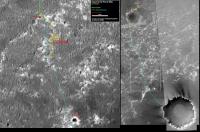
Route map, updated to sol 851.
QUOTE (ylbs101 @ Jun 16 2006, 06:56 PM)  Tesheiner, I registered today just to post a big THANK YOU for all your efforts over the past 2.5 years -- keeping a sol-ly route map of Opportunity current. Great Job! Tom Thanks for your kind words, Tom. ... but 2.5 years is too much! I was even unaware of the existence of this great forum. |
|
|
|
|
|
|
Jun 16 2006, 05:37 PM
Post
#1536
|
|
 Member Group: Members Posts: 648 Joined: 9-May 05 From: Subotica Member No.: 384 |
QUOTE (Tesheiner @ Jun 16 2006, 07:33 PM) ... but 2.5 years is too much! I was even unaware of the existence of this great forum. Those were "the dark ages" when we could wait months to see MER locations update on JPL/NASA/MER site... Thank you Tesheiner from me too.... -------------------- The scientist does not study nature because it is useful; he studies it because he delights in it, and he delights in it because it is beautiful.
Jules H. Poincare My "Astrophotos" gallery on flickr... |
|
|
|
|
Jun 17 2006, 03:13 AM
Post
#1537
|
|
|
Senior Member Group: Members Posts: 1636 Joined: 9-May 05 From: Lima, Peru Member No.: 385 |
Next week, Oppy will slow down the transverse due to restricted sols. The source of the information is from Mars' JPL.
Next week the rover will be on restricted sols, meaning the end-of-sol data from the rover does not get to Earth until late in the day, so the team plans every other day without it. The plan will be for Opportunity to drive every other day. On the days off, the team will plan light remote sensing and downlink some of the unsent data that is building up in memory. Rodolfo |
|
|
|
|
Jun 17 2006, 02:44 PM
Post
#1538
|
|
|
Member Group: Members Posts: 530 Joined: 21-March 06 From: Canada Member No.: 721 |
QUOTE (RNeuhaus @ Jun 16 2006, 09:13 PM) Next week, Oppy will slow down the transverse due to restricted sols. The source of the information is from Mars' JPL. The part of the report I find interesting is this: Sol 846: After little progress in two adjacent troughs, Opportunity moved one more trough to the west. Slip checks were used to prevent driving with over 40 percent slip. The soil was relatively firm, and the rover made 9 meters (30 feet) of progress. Sol 847: Opportunity conducted atmospheric science and took rear-looking images with its navigation camera. This was the point at which I thought perhaps they were on the verge of another embedding and they did indeed make a course correction. The hazcam shots hinted at a bit of a mess when they did this, and I have been waiting to see the rear navcam shots of this area. The report seems to indicate those pictures were taken on sol 847, but they have not yet appeared on either JPL or exploratorium sites. I would like to know more about how they managed a turn and drive so quickly in an area that was causing them slippage problems. Brian |
|
|
|
|
Jun 17 2006, 03:19 PM
Post
#1539
|
|
|
Member Group: Members Posts: 235 Joined: 2-August 05 Member No.: 451 |
Is it realistic that with the restricted Sols and the upcoming soft terrain that Opportunity will get to the edge of this old crater next week? Are we expecting that the terrain after that will be more rigid?
|
|
|
|
|
Jun 17 2006, 04:14 PM
Post
#1540
|
|
|
Senior Member Group: Members Posts: 1636 Joined: 9-May 05 From: Lima, Peru Member No.: 385 |
QUOTE (antoniseb @ Jun 17 2006, 10:19 AM) Is it realistic that with the restricted Sols and the upcoming soft terrain that Opportunity will get to the edge of this old crater next week? Are we expecting that the terrain after that will be more rigid? I am neither sure about the advance type of surface since the MOC does not show good resolution pictures. Surely, MERB is approaching a large pool of outcrop which will help it to transverse climbing small crests of sand toward East until the point in which MERB will go straight southward to CC. Rodolfo |
|
|
|
|
Jun 18 2006, 09:01 PM
Post
#1541
|
||
|
Senior Member Group: Moderator Posts: 4279 Joined: 19-April 05 From: .br at .es Member No.: 253 |
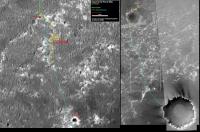
An updated route map (sol 853)
|
|
|
|
|
|
|
Jun 19 2006, 02:21 AM
Post
#1542
|
|
|
Senior Member Group: Members Posts: 1636 Joined: 9-May 05 From: Lima, Peru Member No.: 385 |
From the Sol 853, Oppy is about
Rodolfo Re-edited on distance correction. |
|
|
|
|
Jun 19 2006, 06:56 PM
Post
#1543
|
|
|
Senior Member Group: Members Posts: 2919 Joined: 14-February 06 From: Very close to the Pyrénées Mountains (France) Member No.: 682 |
[quote name='RNeuhaus' date='Jun 19 2006, 04:21 AM' post='58881']
From the Sol 853, Oppy is about 306 meters from the north rim Corner Crater. Rodolfo Using last week speed as a reference and assuming there is 2.5 the distance AND 10 days of restricted sols we'll need another 20 sols to get to Beagle! Bigre... -------------------- |
|
|
|
|
Jun 19 2006, 11:13 PM
Post
#1544
|
||
|
Solar System Cartographer Group: Members Posts: 10149 Joined: 5-April 05 From: Canada Member No.: 227 |
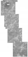
This is the latest version of my Opportunity map, just from Erebus to Beagle. The 100 m grid distances are counted from the landing site. They are only approximate. Each big square is 500 m across and will eventually be a separate illustration.
I'll be in the UK for the next three weeks with only very limited access to UMSF, but I hope we'll reach a conclusion about the location of the beacon during that time. Phil
-------------------- ... because the Solar System ain't gonna map itself.
Also to be found posting similar content on https://mastodon.social/@PhilStooke NOTE: everything created by me which I post on UMSF is considered to be in the public domain (NOT CC, public domain) |
|
|
|
|
|
|
Jun 20 2006, 12:24 AM
Post
#1545
|
|
 Administrator Group: Admin Posts: 5172 Joined: 4-August 05 From: Pasadena, CA, USA, Earth Member No.: 454 |
Thanks for sharing your excellent maps, Phil -- duly blogged!
http://www.planetary.org/blog/article/00000611/ --Emily -------------------- My website - My Patreon - @elakdawalla on Twitter - Please support unmannedspaceflight.com by donating here.
|
|
|
|
|

|
Lo-Fi Version | Time is now: 23rd April 2024 - 05:42 PM |
|
RULES AND GUIDELINES Please read the Forum Rules and Guidelines before posting. IMAGE COPYRIGHT |
OPINIONS AND MODERATION Opinions expressed on UnmannedSpaceflight.com are those of the individual posters and do not necessarily reflect the opinions of UnmannedSpaceflight.com or The Planetary Society. The all-volunteer UnmannedSpaceflight.com moderation team is wholly independent of The Planetary Society. The Planetary Society has no influence over decisions made by the UnmannedSpaceflight.com moderators. |
SUPPORT THE FORUM Unmannedspaceflight.com is funded by the Planetary Society. Please consider supporting our work and many other projects by donating to the Society or becoming a member. |
|