InSight Surface Operations, 26 Nov 2018- 21 Dec 2022 |

  |
InSight Surface Operations, 26 Nov 2018- 21 Dec 2022 |
 Dec 28 2018, 09:53 PM Dec 28 2018, 09:53 PM
Post
#376
|
|
|
Senior Member  Group: Members Posts: 1043 Joined: 17-February 09 Member No.: 4605 |
The tether is only partly deployed, presumably to provide a worst case characterisation of vibration. The tether will be completely fed out and on the ground for operation.
|
 |
 
|
|
Dec 30 2018, 03:22 AM
Post
#377
|
|
 Senior Member Group: Members Posts: 2428 Joined: 30-January 13 From: Penang, Malaysia. Member No.: 6853 |
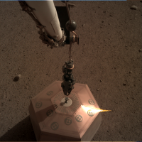
A stereo pair of IDC images are now available on the InSight Raw image server.
They show the grapple positioned just to the side of SEIS. Maybe to update the digital elevation map after SEIS was levelled? Or possibly to cross check data from the instruments inclinometers after levelling? Sol 32 images link EDIT: A single sol 32 ICC image came down later, the arm was no longer adjacent to SEIS and I can see no obvious change to the tether or SEIS comparing it to the sol 30 ICC image |
|
|
|
|
Jan 2 2019, 09:50 AM
Post
#378
|
|
 Junior Member Group: Members Posts: 27 Joined: 15-January 08 Member No.: 4014 |
Hi,
I probably missed some information about SEIS deployment, but...enlight me please - how far from the spacecraft was it placed? 1 meter? Two? Thanks in adv for information. Maciej -------------------- iss.astronet.pl
moonshot.astronet.pl |
|
|
|
|
Jan 2 2019, 02:41 PM
Post
#379
|
|
|
Senior Member Group: Members Posts: 2920 Joined: 14-February 06 From: Very close to the Pyrénées Mountains (France) Member No.: 682 |
Some explanations on how they use the sundial to orientate SEIS by finding where North is +- 2°
https://www.seis-insight.eu/fr/actualites/4...e-nord-sur-mars -------------------- |
|
|
|
|
Jan 2 2019, 08:04 PM
Post
#380
|
|
|
Forum Contributor Group: Members Posts: 1372 Joined: 8-February 04 From: North East Florida, USA. Member No.: 11 |
QUOTE (Station @ Jan 2 2019, 09:50 AM)  Hi, I probably missed some information about SEIS deployment, but...enlight me please - how far from the spacecraft was it placed? 1 meter? Two? Thanks in adv for information. Maciej 1.8m, about the max they could reach. |
|
|
|
|
Jan 2 2019, 10:04 PM
Post
#381
|
|
|
Member Group: Members Posts: 866 Joined: 15-March 05 From: Santa Cruz, CA Member No.: 196 |
With the tether being three meters in length, and the SEIS placed at full-IDA reach, it seems the remaining 0.9 meters was intended for slack that will be carefully arranged later in the process.
For a great visual sense of sensor placement we have Phil Stooke's map thread |
|
|
|
|
Jan 2 2019, 11:35 PM
Post
#382
|
|
|
Senior Member Group: Members Posts: 2428 Joined: 30-January 13 From: Penang, Malaysia. Member No.: 6853 |
QUOTE (Station @ Jan 2 2019, 05:50 PM) I probably missed some information about SEIS deployment, .... According to this release link "The area where SEIS now rests is directly in front of the robotic arm (to ensure that the umbilical cord connecting the instrument to the undercarriage rests flat on the ground), and as far away as possible (1 , 65 meters) of the probe, so as to minimize disturbances. The speed with which the engineers and geologists chose this removal site is related to the leniency of the area where the probe landed on November 26th. With a very small slope (only 2 to 3 degrees of inclination) and a striking absence of pebbles, almost all of the terrain located south of the landing gear and within reach of the robotic arm was suitable for the deployment of the seismometer." (Google Translate) |
|
|
|
|
Jan 3 2019, 12:44 AM
Post
#383
|
||
|
Senior Member Group: Members Posts: 2428 Joined: 30-January 13 From: Penang, Malaysia. Member No.: 6853 |
Sol 35 images on the server (link), they show the grapple being placed at varying heights above the center of SEIS and the last image from ICC shows the arm removed from the scene.
If I had to guess.. they could have practising arm placements for accurate deployment of the wind and thermal shield (WTS)  If correct we may get to see the WTS chain mail skirt soon Sun Dials and Chain Mail on Mars, some old school technology never gets old If correct we may get to see the WTS chain mail skirt soon Sun Dials and Chain Mail on Mars, some old school technology never gets old
|
|
|
|
|
|
|
Jan 3 2019, 09:34 PM
Post
#384
|
||
|
Senior Member Group: Members Posts: 2428 Joined: 30-January 13 From: Penang, Malaysia. Member No.: 6853 |
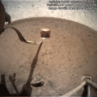
Sol 37 images are on the server (Link).
ICC frames show us the SEIS tether has been released from its storage box and is now on the ground Here is a simple GIF of the before and after.
|
|
|
|
|
|
|
Jan 4 2019, 12:39 AM
Post
#385
|
|
|
Forum Contributor Group: Members Posts: 1372 Joined: 8-February 04 From: North East Florida, USA. Member No.: 11 |
[quote name='PaulH51' post='243134' date='Jan 3 2019, 09:34 PM']Sol 37 images are on the server (Link).
ICC frames show us the SEIS tether has been released from its storage box and is now on the ground Here is a simple GIF of the before and after. Very cool, more visible progress. |
|
|
|
|
Jan 4 2019, 02:01 AM
Post
#386
|
|
|
Member Group: Members Posts: 866 Joined: 15-March 05 From: Santa Cruz, CA Member No.: 196 |
QUOTE (PaulH51 @ Jan 2 2019, 04:44 PM) <snipsnip> If correct we may get to see the WTS chain mail skirt soon Sun Dials and Chain Mail on Mars, some old school technology never gets old <snipsnip>Wow.. until you mentioned it i thought it was just the skirt, so yes actual chain mail with a quite artfully designed platelet structure at that, to be fitted to our little seismometer battling dust devils on the planet of war, amazing! I was quite surprised to read the following, as i'd interpreted Mars' winds to be ineffectual of much more than moving sand and dust around and perhaps rattling solar panels, but i guess with such good ground connection a passing dust devil could perhaps induce quite an impressive umbrella effect on the dome (now im wondering what the upper m/s limit of DD winds are): QUOTE Despite the great care taken in its design, it is not impossible that violent gusts of wind or a dust devil might dislodge or even lift the [9.5 kg] dome, causing it to fly away. The shield has nonetheless been developed to withstand squalls of 60 m/s and should even be able to survive winds of 100 m/s.
|
|
|
|
|
Jan 5 2019, 10:09 PM
Post
#387
|
|
 Member Group: Members Posts: 610 Joined: 23-February 07 From: Occasionally in Columbia, MD Member No.: 1764 |
QUOTE (atomoid @ Jan 3 2019, 09:01 PM) a passing dust devil could perhaps induce quite an impressive umbrella effect on the dome (now im wondering what the upper m/s limit of DD winds are): I find that pressure is a more intuitive measure than windspeed - roughly speaking the dynamic pressure of the circumferential winds (i.e. rho * V^2, ignoring a factor of 2) is the same magnitude as the pressure drop in the center of the vortex. This is true for cyclostrophic balance in rotating wind systems in general, on Earth or Mars. Like most things, there are lots of small ones and a few big ones - dust devil pressure drops seem to follow a power law, with a cumulative slope of about -2 or so. Pathfinder and Phoenix observed one or a few devils a day with drops of 0.5 Pascals, a 5 Pascal drop would be expected to occur around 100x less often, but is still reasonable to expect. A 50 Pascal drop (~10% of the total atmospheric pressure of 700 Pa or so, 7 mbar) isnt realistic Now, if the windshield on InSight weighs 9kg, call that 35 Newtons on Mars. It's what, 0.5m across? So maybe 0.2 m2 in area. So its weight per unit area is 170 Pascals. A 5 Pascal drop, or even a 25 Pascal drop, isnt going to budge it. (I made a rather hokey extrapolation of this sort in considering deaths by dust devil in this paper (open access), discusses weight per unit area of barn doors etc... https://link.springer.com/article/10.1007/s11214-016-0239-2 ) Terrestrial dust devils typically have a pressure drop of tens to a couple of hundred Pascals (say 0.5 to 2 mbar, or 0.1% of the total pressure. Hurricanes can have pressure drops of several tens of mbar, or thousands of Pascals) QUOTE (atomoid @ Jan 3 2019, 09:01 PM) a passing dust devil could perhaps induce quite an impressive umbrella effect on the dome (now im wondering what the upper m/s limit of DD winds are):
|
|
|
|
|
Jan 8 2019, 02:02 AM
Post
#388
|
||
|
Senior Member Group: Members Posts: 2428 Joined: 30-January 13 From: Penang, Malaysia. Member No.: 6853 |
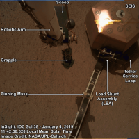
Annotated and processed GIF that shows the release of the load shunt assembly on the SEIS cable service loop.
I used 2 images that were already roughly aligned and at similar LMST I wondering if they will have to use the scoop to open the loop by tugging on the tether pinning mass?
|
|
|
|
|
|
|
Jan 8 2019, 07:30 AM
Post
#389
|
||
|
Solar System Cartographer Group: Members Posts: 10151 Joined: 5-April 05 From: Canada Member No.: 227 |
Very nice!
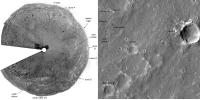
I have been looking at distant features. Here are a few things which I think I have identified correctly. I am still thinking about some other things. The distant ridge to the east is a wrinkle ridge 10 km east of the landing site. Phil
-------------------- ... because the Solar System ain't gonna map itself.
Also to be found posting similar content on https://mastodon.social/@PhilStooke Maps for download (free PD: https://upload.wikimedia.org/wikipedia/comm...Cartography.pdf NOTE: everything created by me which I post on UMSF is considered to be in the public domain (NOT CC, public domain) |
|
|
|
|
|
|
Jan 8 2019, 06:16 PM
Post
#390
|
|
|
Senior Member Group: Members Posts: 1582 Joined: 14-October 05 From: Vermont Member No.: 530 |
QUOTE (PaulH51 @ Jan 7 2019, 09:02 PM) I wondering if they will have to use the scoop to open the loop by tugging on the tether pinning mass? You think there is an issue? I don't know what the change is supposed to be/do mechanically. |
|
|
|
|

|
Lo-Fi Version | Time is now: 25th April 2024 - 07:17 PM |
|
RULES AND GUIDELINES Please read the Forum Rules and Guidelines before posting. IMAGE COPYRIGHT |
OPINIONS AND MODERATION Opinions expressed on UnmannedSpaceflight.com are those of the individual posters and do not necessarily reflect the opinions of UnmannedSpaceflight.com or The Planetary Society. The all-volunteer UnmannedSpaceflight.com moderation team is wholly independent of The Planetary Society. The Planetary Society has no influence over decisions made by the UnmannedSpaceflight.com moderators. |
SUPPORT THE FORUM Unmannedspaceflight.com is funded by the Planetary Society. Please consider supporting our work and many other projects by donating to the Society or becoming a member. |
|