InSight Surface Operations, 26 Nov 2018- 21 Dec 2022 |

  |
InSight Surface Operations, 26 Nov 2018- 21 Dec 2022 |
 Jan 30 2020, 07:08 PM Jan 30 2020, 07:08 PM
Post
#841
|
|
 Member  Group: Members Posts: 684 Joined: 24-July 15 Member No.: 7619 |
QUOTE (atomoid @ Jan 30 2020, 12:02 AM)  Here is one set of the parallel renderings: Oh WOW. That is a HUGE amount of missing volume! Can that ALL be from compaction? I'm starting to think there is a void UNDER the duricrust, and the mole punched a small hole through which is allowing the soil to drop down into a void? |
 |
 
|
|
Jan 30 2020, 08:46 PM
Post
#842
|
|
|
Senior Member Group: Members Posts: 3516 Joined: 4-November 05 From: North Wales Member No.: 542 |
QUOTE (HSchirmer @ Jan 30 2020, 08:08 PM) Can that ALL be from compaction? It was partly wondering about this that prompted me to ask the question about densities a few posts back. Apart from the visible void there is the volume now occupied by the probe itself. If the regolith here is indeed very porous and lightly packed that would initially have helped the mole to sink. Maybe the hammering causes the stuff to collapse and there is now a much denser sand 'puddle' at the bottom of the hole. |
|
|
|
|
Jan 31 2020, 11:13 AM
Post
#843
|
|
 Senior Member Group: Members Posts: 2530 Joined: 20-April 05 Member No.: 321 |
The presence of duricrust implies the previous presence of saline water from which the water departed. To some extent, this compaction must be showing us how much water there once was.
|
|
|
|
|
Jan 31 2020, 06:53 PM
Post
#844
|
|
|
Member Group: Members Posts: 684 Joined: 24-July 15 Member No.: 7619 |
QUOTE (JRehling @ Jan 31 2020, 11:13 AM) The presence of duricrust implies the previous presence of saline water from which the water departed. To some extent, this compaction must be showing us how much water there once was. IIRC, there was a paper about a year ago that about areas that were likely re-worked by Northern-ocean Tsunami deposits, the Insight landing ellipse was inside the area that could be reworked. That would make the site roughly analogous to the US channeled scab lands or other areas subjected to recurrent catastrophic glacial lake flooding. |
|
|
|
|
Feb 2 2020, 10:51 AM
Post
#845
|
|
|
Senior Member Group: Members Posts: 1043 Joined: 17-February 09 Member No.: 4605 |
QUOTE (JRehling @ Jan 31 2020, 11:13 AM) The presence of duricrust implies the previous presence of saline water from which the water departed. To some extent, this compaction must be showing us how much water there once was. The scenario seems to be that the mole encountered a duricrust layer beneath the reasonably loose regolith. When the mole encountered the cemented layer there was insufficient friction against the barrel from the surface deposits to let it penetrate and the mole effectively bounced around compacting the (comparatively) loose material. The friction applied by the scoop permitted the mole to begin to penetrate the duricrust but the effect diminished with depth and the mole bounced back, possibly with loose material sifting down to progressively refill the hole. There is no way to tell how deep the duricrust layer is but it could be measured in metres, representing the surface a long time ago. |
|
|
|
|
Feb 3 2020, 12:23 AM
Post
#846
|
||
|
Founder Group: Chairman Posts: 14432 Joined: 8-February 04 Member No.: 1 |
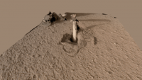
Took the Sol 420 IDC images and was able to extract a 3D model from them...
https://sketchfab.com/3d-models/insight-hp3...281e93d4d8b42d7
Attached thumbnail(s)
|
|
|
|
|
|
|
Feb 3 2020, 05:34 AM
Post
#847
|
|
|
Senior Member Group: Members Posts: 2530 Joined: 20-April 05 Member No.: 321 |
QUOTE (serpens @ Feb 2 2020, 03:51 AM) The scenario seems to be that the mole encountered a duricrust layer beneath the reasonably loose regolith. Correct me if I'm reading this wrong, but that seems to me to be the opposite (vertically speaking) of what the team blog said on December 23: "The most convincing (at least to me) explanation for the backing out of the mole assumes that the duricrust is underlain by cohesionless sand." And further, " motion of the mole provides an estimate for the thickness of the duricrust of about 20cm." You speak of a duricrust layer under loose regolith, but they speak of loose (cohesionless) material below the duricrust. And you speak of unknown thickness perhaps meters and they speak of about 20 cm. Perhaps they are wrong (they express uncertainty) but it seems like you are knowingly or unknowingly contradicting them. Again, my understanding from this is that there is a duricrust on the top, and that it has a definite end within cm from the surface. Viking found this to be just a couple of cm, but here the team supposes about 20cm. Then, there is a loose layer of unknown depth below that in this locality. Do you think the team is wrong or are we interpreting the wording differently? (I'm sure there is some degree of surface dust above the duricrust, but I was interpreting that as negligible, approximately or less than 1cm.) https://www.dlr.de/blogs/en/all-blog-posts/...on-logbook.aspx |
|
|
|
|
Feb 3 2020, 11:21 PM
Post
#848
|
|
|
Member Group: Members Posts: 866 Joined: 15-March 05 From: Santa Cruz, CA Member No.: 196 |
Wow! incredible sketchfab djellison, thanks!
It seems we've managed to collapse the sub-duricrust layer into a jumble of sand with what looks like the cohesiveness of styrofoam pellets, seemingly held together by a very weakly cemented loose matrix of muddy salt residues left over from eons of dessication, never disturbed until now. I'd imagine walking very cautiously here with my boot plunging into the subsurface regularly like dry quicksands. To further the Earthly comparison, very similar to what happens regularly at the beach when a layer fine sands is washed to cover over a deep layer of very large sand grains that were deposited without any small grains to fill the gaps, and so when the tide goes out and it all dries up it doesnt collapse under its own weight but remains loosely cemented in place, so you walk along as your foot plunges through a crispy crust to squish away large volumes of the larger mobile sand grains below, sinking deeply and softly with every step. So now doing some very unplanned-for trenching studies in order to reveal the true cross section of the soil layers and how they react might prove critical to making safe progress with whatever plans are in the pipe..? |
|
|
|
|
Feb 3 2020, 11:48 PM
Post
#849
|
|
|
Senior Member Group: Members Posts: 2511 Joined: 13-September 05 Member No.: 497 |
QUOTE (atomoid @ Feb 3 2020, 03:21 PM) I'd imagine walking very cautiously here with my boot plunging into the subsurface regularly like dry quicksands. Did the lander footpads do anything unusual? Sol 10 and 14 images of the footpads look fairly normal. -------------------- Disclaimer: This post is based on public information only. Any opinions are my own.
|
|
|
|
|
Feb 4 2020, 02:01 AM
Post
#850
|
|
|
Member Group: Members Posts: 684 Joined: 24-July 15 Member No.: 7619 |
QUOTE (JRehling @ Jan 31 2020, 12:13 PM) The presence of duricrust implies the previous presence of saline water from which the water departed. To some extent, this compaction must be showing us how much water there once was. Curious- why SALINE water? I was under the impression that caliche can form from groundwater and precipitation. Now, when I think of weathering of rocks on Earth, as applied to Mars, I think of thermal (thermal-onion-skin, or freeze-thaw-splitting), physical (grinding away by moving sand or ice), and finally chemical (water dissolving the minerals (usually cations) that cement the grains together. It would seem that Insight landing site resembles the Sonoran/Sahara desert model of caliche formation where occasional rain dissolves minerals as it trickles down through the sand, and either forms a duricrust at the water horizon (e.g. bath tub ring) or vaporizes and deposits the minerals at a higher horizon (e.g. shower scale). |
|
|
|
|
Feb 4 2020, 03:21 AM
Post
#851
|
|
|
Solar System Cartographer Group: Members Posts: 10151 Joined: 5-April 05 From: Canada Member No.: 227 |
Quick recap of arm activities: on sol 417 the scoop was lifted off the soil so the pit could be imaged, and then its tip was pushed down into the surface a bit further out than the hole. I thought that might be a prelude to trying to pull some soil into the hole. On sol 420 the tip of the scoop was pushed down on the far edge of the hole, causing a bit of wall collapse into the hole.
Phil -------------------- ... because the Solar System ain't gonna map itself.
Also to be found posting similar content on https://mastodon.social/@PhilStooke Maps for download (free PD: https://upload.wikimedia.org/wikipedia/comm...Cartography.pdf NOTE: everything created by me which I post on UMSF is considered to be in the public domain (NOT CC, public domain) |
|
|
|
|
Feb 4 2020, 06:36 AM
Post
#852
|
|
|
Senior Member Group: Members Posts: 2530 Joined: 20-April 05 Member No.: 321 |
QUOTE (HSchirmer @ Feb 3 2020, 07:01 PM) Curious- why SALINE water? This article discusses the (relatively well understood) present nature of and (not at all well understood) origin of the martian duricrust. "Evidence of water and salt is apparent in the abundant duricrusts (weakly-cemented soils) observed on Mars. These duricrusts, and the soluble salts that cement them, are observed at every landing site on Mars, and remote sensing reveals that salts and duricrusts are globally widespread." https://www.hou.usra.edu/meetings/lpsc2019/pdf/3077.pdf "Saline" means "solution of salt in water." One way or another, salt was dissolved in water here. The details of the dynamics are still not apparent. |
|
|
|
|
Feb 4 2020, 06:59 PM
Post
#853
|
|
|
Member Group: Members Posts: 684 Joined: 24-July 15 Member No.: 7619 |
QUOTE (JRehling @ Feb 4 2020, 07:36 AM) the (not at all well understood) origin of the martian duricrust. Ooh, thanks, very interesting article!QUOTE (JRehling @ Feb 4 2020, 07:36 AM) This article discusses the (relatively well understood) present nature of {he martian duricrust} Eh, depends on what UNDERSTOOD means.-"There is a layer of hard stuff all over mars". -"We have identified these %s of cations (K/Na/Ca/Mg) and these percentages of anions (various ITES and ATES) and have confirmed this with spectrophotometry in the lab and in the field." I spent MANY hours in a grad-school laboratory running ion-chelation-spectrophotometry standard curves for every soluble cation we could find. Even ran samples in the hot lab to see if we could detect isotopes. Measuring the spectrum of duricrust, in one area, and understanding what it is made of? Different things entirely. |
|
|
|
|
Feb 6 2020, 01:09 AM
Post
#854
|
||
|
Solar System Cartographer Group: Members Posts: 10151 Joined: 5-April 05 From: Canada Member No.: 227 |
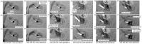
Here is a graphic summary of the mole operations since the support structure was lifted off the mole.
Phil
-------------------- ... because the Solar System ain't gonna map itself.
Also to be found posting similar content on https://mastodon.social/@PhilStooke Maps for download (free PD: https://upload.wikimedia.org/wikipedia/comm...Cartography.pdf NOTE: everything created by me which I post on UMSF is considered to be in the public domain (NOT CC, public domain) |
|
|
|
|
|
|
Feb 13 2020, 01:02 PM
Post
#855
|
||
|
Member Group: Members Posts: 684 Joined: 24-July 15 Member No.: 7619 |
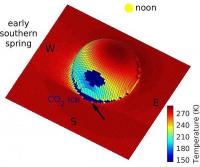
Interesting paper - seasonal water frost on Mars could form surface brines on the shady side of boulders, at around 30' latitude. So, northern side of northern hemisphere boulders, southern side of southern hemisphere boulders might show signs of recent liquid water.
Now, if you INVERT a round boulder, you get a crater. A crater has identical-but- inverse angles of incident sunlight falling on the surface. So, perhaps we should look for evidence of recent brines in the shaded cusp of craters. So, southern rim of northern hemisphere craters and northern rim of southern hemisphere craters- the place where the last shade would be. Now, which part of the crater rim is Insight nearest to ? North South East, West? Salt water may periodically form on the surface of Mars https://www.marsdaily.com/reports/Salt_wate...f_Mars_999.html Mars: Quantitative Evaluation of Crocus Melting behind Boulders https://iopscience.iop.org/article/10.3847/1538-4357/ab612f
Attached thumbnail(s)
|
|
|
|
|
|
|

|
Lo-Fi Version | Time is now: 25th April 2024 - 05:45 PM |
|
RULES AND GUIDELINES Please read the Forum Rules and Guidelines before posting. IMAGE COPYRIGHT |
OPINIONS AND MODERATION Opinions expressed on UnmannedSpaceflight.com are those of the individual posters and do not necessarily reflect the opinions of UnmannedSpaceflight.com or The Planetary Society. The all-volunteer UnmannedSpaceflight.com moderation team is wholly independent of The Planetary Society. The Planetary Society has no influence over decisions made by the UnmannedSpaceflight.com moderators. |
SUPPORT THE FORUM Unmannedspaceflight.com is funded by the Planetary Society. Please consider supporting our work and many other projects by donating to the Society or becoming a member. |
|