Apollo Sites from LRO |

  |
Apollo Sites from LRO |
 Jul 21 2009, 07:26 PM Jul 21 2009, 07:26 PM
Post
#106
|
|
 Member  Group: Members Posts: 646 Joined: 23-December 05 From: Forest of Dean Member No.: 617 |
-------------------- --
Viva software libre! |
 |
 
|
|
Jul 22 2009, 01:41 AM
Post
#107
|
|
|
Solar System Cartographer Group: Members Posts: 10150 Joined: 5-April 05 From: Canada Member No.: 227 |
A new stereo view of Taurus-Littrow is on the LROC site now.
Phil -------------------- ... because the Solar System ain't gonna map itself.
Also to be found posting similar content on https://mastodon.social/@PhilStooke NOTE: everything created by me which I post on UMSF is considered to be in the public domain (NOT CC, public domain) |
|
|
|
|
Jul 22 2009, 09:25 PM
Post
#108
|
|
|
Member Group: Members Posts: 204 Joined: 14-April 06 From: Seattle, WA Member No.: 745 |
QUOTE (robspace54 @ Jul 17 2009, 07:03 PM)  And a pilot's adage "When in doubt, land long." He did land long, Rob And being a good pilot, he knew it at the time: 04 07 05 32 CMP (Collins) When in doubt, land long. 04 07 05 _8 CDR (Armstrong) So we did. Interchange between Collins and Armstrong from the Apollo 11 Technical Air-to-Ground Voice Transcription pg. 322 (324 of pdf) |
|
|
|
|
Jul 23 2009, 12:42 AM
Post
#109
|
|
 Senior Member Group: Members Posts: 3419 Joined: 9-February 04 From: Minneapolis, MN, USA Member No.: 15 |
When landing *anything* on what is essentially a horizontal flight profile for all but the last 100 feet, manned or unmanned, it is always easier to land long. Stopping short means taking out more of your horizontal velocity than planned, more quickly and higher than planned. That maneuver inevitably ends up costing more in fuel than any of the alternatives for steering away from your targeted site. Landing long costs you a little less fuel, and gives you more time to find an acceptable site.
I'm hoping that this kind of thinking is being applied to automated landing systems -- you don't always have a parachute system to kill your horizontal velocity, after all. -the other Doug -------------------- The trouble ain't that there is too many fools, but that the lightning ain't distributed right. -Mark Twain
|
|
|
|
|
Jul 23 2009, 02:19 AM
Post
#110
|
|
 Senior Member Group: Members Posts: 1465 Joined: 9-February 04 From: Columbus OH USA Member No.: 13 |
More fundamentally, Armstrong later said "I was just absolutely adamant about my God-given right to be wishy-washy about where I was going to land."
-------------------- |
|
|
|
|
Jul 24 2009, 09:40 PM
Post
#111
|
||
|
Solar System Cartographer Group: Members Posts: 10150 Joined: 5-April 05 From: Canada Member No.: 227 |
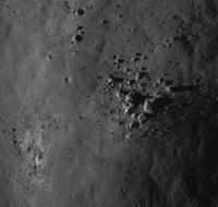
Here's a nice big pile of rocks, on a hilltop south of the Taurus-Littrow Valley. Phil -------------------- ... because the Solar System ain't gonna map itself.
Also to be found posting similar content on https://mastodon.social/@PhilStooke NOTE: everything created by me which I post on UMSF is considered to be in the public domain (NOT CC, public domain) |
|
|
|
|
|
|
Jul 26 2009, 12:20 PM
Post
#112
|
||
|
Solar System Cartographer Group: Members Posts: 10150 Joined: 5-April 05 From: Canada Member No.: 227 |
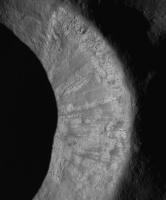
Love these landslides on a crater wall south of the Apollo 14 site.
Phil
-------------------- ... because the Solar System ain't gonna map itself.
Also to be found posting similar content on https://mastodon.social/@PhilStooke NOTE: everything created by me which I post on UMSF is considered to be in the public domain (NOT CC, public domain) |
|
|
|
|
|
|
Jul 27 2009, 04:20 PM
Post
#113
|
|
 The Poet Dude Group: Moderator Posts: 5551 Joined: 15-March 04 From: Kendal, Cumbria, UK Member No.: 60 |
-------------------- |
|
|
|
|
Jul 27 2009, 08:19 PM
Post
#114
|
|
|
Member Group: Members Posts: 156 Joined: 22-May 09 From: Ireland Member No.: 4792 |
QUOTE (Stu @ Jul 27 2009, 05:20 PM) Poem celebrating LRO's portrait of Tranquility Base: http://twitpic.com/btqo5 Very nice Stu! ..."Here Mankind left the slavery of Terra's tyrannical gravity Behind and dipped its first, trembling toe in the surf Surging at the very edge of that ocean of the night, And first caught sight of our own bright reflection In the cosmos' curious eyes." Caught a moment there alright. Wonder how future poets living on the Moon will write about it -- on the reduced gravity, the continuous black inky sky, the earth rises and sets, and, of course, the landscape? Ahead...new thoughts and new experiences for a new Mankind. John |
|
|
|
|
Jul 27 2009, 10:16 PM
Post
#115
|
|
 Member Group: Members Posts: 547 Joined: 1-May 06 From: Scotland (Ecosse, Escocia) Member No.: 759 |
QUOTE (Phil Stooke @ Jul 26 2009, 01:20 PM) Love these landslides on a crater wall south of the Apollo 14 site. I noticed those slides, indeed lovely, and wondered if their apparent freshness (unlike the boulder tracks of Split Rock at Taurus Littrow) is deceptive. Would you hazard a guess at an age, Phil? |
|
|
|
|
Jul 27 2009, 10:50 PM
Post
#116
|
|
|
Senior Member Group: Members Posts: 3419 Joined: 9-February 04 From: Minneapolis, MN, USA Member No.: 15 |
Phil, I have a question and several others here may enjoy hearing the answer.
When the Fra Mauro site was designated for Apollo 13, they had designed traverses for various landing locations, including a traverse in case the LM landed long, to the west of the Doublet craters. This would have put Cone crater out of range for a crew exploring on foot, so the primary EVA-2 objective from this western location would have been something called Star crater. (When Lovell was leaving the Moon, he made a comment that he was "still looking for Star crater," so I know the crew was very aware of it.) I've only ever seen Star crater labeled on a map within the Apollo 13 presskit in PDF format, in which you really can't pick out the crater itself. Do you have any way of determining which crater is Star and identifying it on the LRO images? As it was west of Doublet, I would have to imagine it's in the current LRO image of the Fra Mauro region. -the other Doug -------------------- The trouble ain't that there is too many fools, but that the lightning ain't distributed right. -Mark Twain
|
|
|
|
|
Jul 27 2009, 11:12 PM
Post
#117
|
|
|
Member Group: Members Posts: 547 Joined: 1-May 06 From: Scotland (Ecosse, Escocia) Member No.: 759 |
I followed the subtle switches in EVA options from 13 to 14 at the time, and I have also looked for Star crater a few times. I had a feeling, perhaps wrong, that it was north of the 13 landing site. The crew also named other craters out west of Doublet - I think one was Sunrise. I have them somewhere in old magazines, not readilly accessible at the moment, but perhaps with some foraging...
|
|
|
|
|
Jul 28 2009, 12:52 AM
Post
#118
|
|
|
Senior Member Group: Members Posts: 3419 Joined: 9-February 04 From: Minneapolis, MN, USA Member No.: 15 |
Yeah -- the 13 main traverse plan was nearly identical to the 14 plan (the primary aim point was moved back east about 60m from 13 to 14, which would have put Aquarius on a fairly steep forward-pitching slope in the "deep depression" that Shepard and Mitchell walked through en route from their LM to their ALSEP site).
But the 13 traverse planning began before Apollo 12 demonstrated the pinpoint landing capability, and so some traverse planning was done for various dispersions. They had plans for over- and under-shoots of as much as a kilometer or two; ISTR seeing a traverse plan for a landing short of Cone Ridge, one for a landing in the valley between Cone and Triplet, the final 14 plan for the landing between Doublet and Triplet, and yet another for a landing downrange of Doublet. However, I also STR that there were no significant north-south dispersions considered, just uprange-downrange. (Any links or examples you might have, Phil, of/to the original 13 traverse plans would be most welcome indeed...) I have to wonder if Lovell expected an overshoot in the primary guidance, since only an overshoot would put Star on their traverse maps, and Lovell was on the record as being determined to do very little LPD-ing and to allow the automatic system land the LM without going into P66 to take manual control. He wanted to demonstrate that the LM was able to land automatically. (Note that every single other CDR in Apollo took over manual control and hand-flew their LMs to their final touchdown points. They used varying degrees of manual control, most of which let the computer control the descent rate while the CDR tooled the LM around with attitude changes. But no one let the LM land in P64, fully automatic mode. Lovell was the only one willing to try it.) One reason I'd enjoy seeing where Star is located is that it was obviously considered a valuable sampling site, and if we land an unmanned Moon rover near to the Fra Mauro site, we'll want to land it a ways away from the Doublet-Triplet-Cone operations area. I'm thinking it would be really kewl to have such a rover do a geologic investigation of Star before moving in to observe the Apollo artifacts to its east from a respectful distance. -the other Doug -------------------- The trouble ain't that there is too many fools, but that the lightning ain't distributed right. -Mark Twain
|
|
|
|
|
Jul 28 2009, 03:12 AM
Post
#119
|
|
|
Solar System Cartographer Group: Members Posts: 10150 Joined: 5-April 05 From: Canada Member No.: 227 |
I'll get to it tomorrow.
Phil -------------------- ... because the Solar System ain't gonna map itself.
Also to be found posting similar content on https://mastodon.social/@PhilStooke NOTE: everything created by me which I post on UMSF is considered to be in the public domain (NOT CC, public domain) |
|
|
|
|
Jul 28 2009, 09:44 AM
Post
#120
|
|
 Member Group: Members Posts: 593 Joined: 20-April 05 Member No.: 279 |
QUOTE (John Moore @ Jul 27 2009, 09:19 PM) ... the reduced gravity, the continuous black inky sky, the earth rises and sets, and, of course, the landscape? Earth'll wax and wane, for those who can see it: but it'll not rise and set for most locations on the Moon. Andy |
|
|
|
|

|
Lo-Fi Version | Time is now: 24th April 2024 - 06:56 PM |
|
RULES AND GUIDELINES Please read the Forum Rules and Guidelines before posting. IMAGE COPYRIGHT |
OPINIONS AND MODERATION Opinions expressed on UnmannedSpaceflight.com are those of the individual posters and do not necessarily reflect the opinions of UnmannedSpaceflight.com or The Planetary Society. The all-volunteer UnmannedSpaceflight.com moderation team is wholly independent of The Planetary Society. The Planetary Society has no influence over decisions made by the UnmannedSpaceflight.com moderators. |
SUPPORT THE FORUM Unmannedspaceflight.com is funded by the Planetary Society. Please consider supporting our work and many other projects by donating to the Society or becoming a member. |
|