Chang'e-4 farside landing mission |

  |
Chang'e-4 farside landing mission |
 Apr 24 2018, 09:39 PM Apr 24 2018, 09:39 PM
Post
#31
|
|
|
Solar System Cartographer  Group: Members Posts: 10226 Joined: 5-April 05 From: Canada Member No.: 227 |
Interesting that Google translates that website to give the relay satellite name 'Bianqiao', but all other sources - AND using Google to translate just the characters for that name, give 'Queqiao'. The names mean Magpie Bridge (relay) and Dragon River (the two small satellites), and there are numerous tweets and stories out there today giving the background.
Late in the year we will presumably get a name for the new rover. Phil -------------------- ... because the Solar System ain't gonna map itself.
Also to be found posting similar content on https://mastodon.social/@PhilStooke Maps for download (free PDF: https://upload.wikimedia.org/wikipedia/comm...Cartography.pdf NOTE: everything created by me which I post on UMSF is considered to be in the public domain (NOT CC, public domain) |
 |
 
|
|
May 20 2018, 10:08 PM
Post
#32
|
|
|
Solar System Cartographer Group: Members Posts: 10226 Joined: 5-April 05 From: Canada Member No.: 227 |
The relay satellite was just launched successfully.
Phil -------------------- ... because the Solar System ain't gonna map itself.
Also to be found posting similar content on https://mastodon.social/@PhilStooke Maps for download (free PDF: https://upload.wikimedia.org/wikipedia/comm...Cartography.pdf NOTE: everything created by me which I post on UMSF is considered to be in the public domain (NOT CC, public domain) |
|
|
|
|
May 20 2018, 10:23 PM
Post
#33
|
|
|
Merciless Robot Group: Admin Posts: 8785 Joined: 8-December 05 From: Los Angeles Member No.: 602 |
Ah, thanks, Phil! Was wondering; didn't seem to be a live feed available anywhere.
-------------------- A few will take this knowledge and use this power of a dream realized as a force for change, an impetus for further discovery to make less ancient dreams real.
|
|
|
|
|
May 20 2018, 10:29 PM
Post
#34
|
|
|
Senior Member Group: Members Posts: 2106 Joined: 13-February 10 From: Ontario Member No.: 5221 |
Someone at the site pointed their phone at a screen, and streamed it out via a Chinese media platform; looks like the micro-satellites also separated successfully.
|
|
|
|
|
May 21 2018, 09:30 AM
Post
#35
|
|
|
Member Group: Members Posts: 157 Joined: 22-May 09 From: Ireland Member No.: 4792 |
|
|
|
|
|
May 25 2018, 10:40 PM
Post
#36
|
|
|
Solar System Cartographer Group: Members Posts: 10226 Joined: 5-April 05 From: Canada Member No.: 227 |
It seems all is well with our new mission - the relay satellite has passed the Moon and is on its way to its L2 halo orbit. The two little moon orbiters are in lunar orbit. Hoping for an image or two from the Saudi camera on one of them.
Phil -------------------- ... because the Solar System ain't gonna map itself.
Also to be found posting similar content on https://mastodon.social/@PhilStooke Maps for download (free PDF: https://upload.wikimedia.org/wikipedia/comm...Cartography.pdf NOTE: everything created by me which I post on UMSF is considered to be in the public domain (NOT CC, public domain) |
|
|
|
|
May 27 2018, 09:56 PM
Post
#37
|
|
|
Solar System Cartographer Group: Members Posts: 10226 Joined: 5-April 05 From: Canada Member No.: 227 |
Twitter: Jonathan McDowell @planet4589 2 hours ago
So it looks like Longjiang-2 (DSLWP-  is in a 350 x 13800 km x 21 deg lunar orbit. Longjiang-1 seems to have failed on May 21 and presumably remains in distant Earth orbit following its lunar flyby is in a 350 x 13800 km x 21 deg lunar orbit. Longjiang-1 seems to have failed on May 21 and presumably remains in distant Earth orbit following its lunar flyby------------------ I spoke prematurely in my last post - all seems well with the other two spacecraft but Longjiang 1 failed. The small camera is on Longjiang 2. I see some reports that radio enthusiasts will be able to download images from the camera, but I don't know the details yet. Phil -------------------- ... because the Solar System ain't gonna map itself.
Also to be found posting similar content on https://mastodon.social/@PhilStooke Maps for download (free PDF: https://upload.wikimedia.org/wikipedia/comm...Cartography.pdf NOTE: everything created by me which I post on UMSF is considered to be in the public domain (NOT CC, public domain) |
|
|
|
| Guest_mcmcmc_* |
Jun 13 2018, 07:30 AM
Post
#38
|
|
Guests |
"Are we there yet?"

|
|
|
|
|
Jun 14 2018, 04:16 PM
Post
#39
|
|
|
Solar System Cartographer Group: Members Posts: 10226 Joined: 5-April 05 From: Canada Member No.: 227 |
-------------------- ... because the Solar System ain't gonna map itself.
Also to be found posting similar content on https://mastodon.social/@PhilStooke Maps for download (free PDF: https://upload.wikimedia.org/wikipedia/comm...Cartography.pdf NOTE: everything created by me which I post on UMSF is considered to be in the public domain (NOT CC, public domain) |
|
|
|
| Guest_mcmcmc_* |
Jun 14 2018, 05:49 PM
Post
#40
|
|
Guests |
QUOTE (Phil Stooke @ Jun 14 2018, 05:16 PM)  Cool! 
|
|
|
|
| Guest_mcmcmc_* |
Jun 14 2018, 06:53 PM
Post
#41
|
|
Guests |
Hayabusa twitter aggregator
http://win98.altervista.org/hayabusa2/TwitterAggregator.html |
|
|
|
|
Jun 14 2018, 07:00 PM
Post
#42
|
|
 Member Group: Members Posts: 127 Joined: 3-September 12 From: Almeria, SE Spain Member No.: 6632 |
Nice pic, but it's not new.
It's from Chang'e-5 T1, from october 2014. This one is new, from the Longjiang-2 micro satellite. The camera has captured its place of origin, Saudi Arabia.  Thorsten 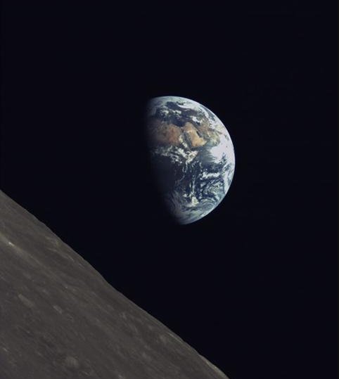 |
|
|
|
|
Jun 14 2018, 07:13 PM
Post
#43
|
|
|
Member Group: Members Posts: 157 Joined: 22-May 09 From: Ireland Member No.: 4792 |
|
|
|
|
| Guest_mcmcmc_* |
Jun 15 2018, 06:51 AM
Post
#44
|
|
Guests |
Better images from Saudi Arabia camera onboard Longjiang-2 satellite, the only survivor of the two small satellites launched together with Queqiao:
 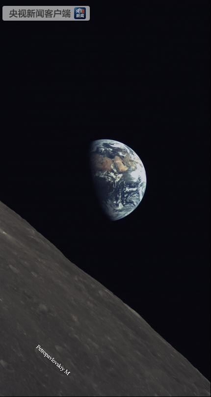 http://www.planetary.org/blogs/jason-davis...earth-pics.html |
|
|
|
|
Aug 6 2018, 10:48 AM
Post
#45
|
||
|
Solar System Cartographer Group: Members Posts: 10226 Joined: 5-April 05 From: Canada Member No.: 227 |
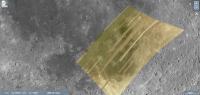
Andrew Jones (https://twitter.com/AJ_FI) reports some new images from the Saudi camera. EDIT - Andrew has just pointed out to me that the image is not from the Saudi camera, but from a second camera which I was not aware of or had forgotten about. This was developed by students in China.
One, which I assume is a mosaic of many image strips, covers Mare Nubium. This shows the image coverage on a background from LRO Quickmap. Phil
-------------------- ... because the Solar System ain't gonna map itself.
Also to be found posting similar content on https://mastodon.social/@PhilStooke Maps for download (free PDF: https://upload.wikimedia.org/wikipedia/comm...Cartography.pdf NOTE: everything created by me which I post on UMSF is considered to be in the public domain (NOT CC, public domain) |
|
|
|
|
|
|

|
Lo-Fi Version | Time is now: 24th September 2024 - 02:08 AM |
|
RULES AND GUIDELINES Please read the Forum Rules and Guidelines before posting. IMAGE COPYRIGHT |
OPINIONS AND MODERATION Opinions expressed on UnmannedSpaceflight.com are those of the individual posters and do not necessarily reflect the opinions of UnmannedSpaceflight.com or The Planetary Society. The all-volunteer UnmannedSpaceflight.com moderation team is wholly independent of The Planetary Society. The Planetary Society has no influence over decisions made by the UnmannedSpaceflight.com moderators. |
SUPPORT THE FORUM Unmannedspaceflight.com is funded by the Planetary Society. Please consider supporting our work and many other projects by donating to the Society or becoming a member. |
|