HAMO, (aka High Altitude Mapping Orbit) |

  |
HAMO, (aka High Altitude Mapping Orbit) |
 Oct 3 2011, 11:34 PM Oct 3 2011, 11:34 PM
Post
#76
|
|
|
Member  Group: Members Posts: 813 Joined: 29-December 05 From: NE Oh, USA Member No.: 627 |
The big thing to me was Dr. Russell's mention of an appreciable iron core, detected though the denity and j2 measurements. So we have a differentiated body. What a shame they lost the magnetometer to budget. Dr. Russell even mentioned that when a questioner asked what other instruments he would have liked included. Craig |
 |
 
|
|
Oct 4 2011, 08:33 PM
Post
#77
|
||
 Senior Member Group: Members Posts: 2492 Joined: 15-January 05 From: center Italy Member No.: 150 |
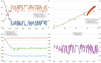
Update with zoomed scale on last 3 weeks:
Height in the last days has been oscillating between 664 and 701 km above nominal 265 km radius. -------------------- I always think before posting! - Marco -
|
|
|
|
|
|
|
Oct 7 2011, 04:12 AM
Post
#78
|
|
|
Member Group: Members Posts: 146 Joined: 31-October 08 Member No.: 4473 |
Full inline quote - with image - removed - ADMIN
Looking at that orbital data, I would have to wonder if that is pretty much the closest to a constant-speed, constant-radius, circular orbit Dawn can manage, with Vesta so flattened and asymmetric. I'm sure the little variations are yielding a picture of the source mass distribution. I can't devolve the gravity figure from the orbit data, doing the math in my head, unless I've had at least 2 beers, and it IS a weeknight. Maybe someone else can help... |
|
|
|
|
Oct 9 2011, 05:54 PM
Post
#79
|
|
|
Senior Member Group: Members Posts: 1582 Joined: 14-October 05 From: Vermont Member No.: 530 |
Today's image of the day is pretty fun to look at:
http://dawn.jpl.nasa.gov/multimedia/imageo...p?date=20111009 A lot going on there. Also-- does anyone know of a good RSS feed to get the image of the day into their reader? |
|
|
|
|
Oct 10 2011, 05:26 AM
Post
#80
|
|
|
Member Group: Members Posts: 184 Joined: 2-March 06 Member No.: 692 |
Yea. It looks like there is a darker (older) layer of material the crater punched into. Is the darker material more loosely consolidated, as it looks to me that the north and south sides of the crater with more dark material slumped, and the pits in the crater bottom are in dark material.
I can't get over how the rays left grooves in the surface. I'm trying to picture in my mind how the impact happened and could do that. |
|
|
|
|
Oct 10 2011, 01:34 PM
Post
#81
|
|
 Senior Member Group: Moderator Posts: 2785 Joined: 10-November 06 From: Pasadena, CA Member No.: 1345 |
Low gravity small body dynamics? The debris flying out gives a trajectory effectively parallel to the ground perhaps and just plows the surface for a really long way?
-------------------- Some higher resolution images available at my photostream: http://www.flickr.com/photos/31678681@N07/
|
|
|
|
|
Oct 11 2011, 04:36 PM
Post
#82
|
|
 Senior Member Group: Members Posts: 1887 Joined: 20-November 04 From: Iowa Member No.: 110 |
This paper written a few months before Dawn reached Vesta claims the impact near Vesta's south pole would have caused Vesta's axis to reorient and made some predictions based on this. Are we seeing any of the features they predicted?
Reoritaion of Vesta: Gravity and Tectonic Predictions |
|
|
|
|
Oct 11 2011, 05:35 PM
Post
#83
|
|
|
Senior Member Group: Members Posts: 1582 Joined: 14-October 05 From: Vermont Member No.: 530 |
3-D perspective view of the south:
http://dawn.jpl.nasa.gov/multimedia/vesta_...olar_region.asp |
|
|
|
|
Oct 11 2011, 05:53 PM
Post
#84
|
||
|
Senior Member Group: Members Posts: 1074 Joined: 21-September 07 From: Québec, Canada Member No.: 3908 |
QUOTE (stevesliva @ Oct 11 2011, 01:35 PM)  3-D perspective view of the south: http://dawn.jpl.nasa.gov/multimedia/vesta_...olar_region.asp That image has 1.5x vertical exaggeration (Why? To make it more spectacular?). Here is the same image without vertical exaggeration (contrast enhanced):
|
|
|
|
|
|
|
Oct 11 2011, 06:02 PM
Post
#85
|
|
|
Member Group: Members Posts: 140 Joined: 20-November 07 Member No.: 3967 |
QUOTE (charborob @ Oct 11 2011, 12:53 PM) That image has 1.5x vertical exaggeration (Why? To make it more spectacular?). Here is the same image without vertical exaggeration (contrast enhanced): "That image" also flattens the surface. Why? Someone please tell me! Can you restore the curvature? |
|
|
|
|
Oct 11 2011, 08:54 PM
Post
#86
|
|
|
Senior Member Group: Members Posts: 1074 Joined: 21-September 07 From: Québec, Canada Member No.: 3908 |
QUOTE (chuckclark @ Oct 11 2011, 02:02 PM) "That image" also flattens the surface. Why? Someone please tell me! Can you restore the curvature? The caption of the released image explains it thus: "This perspective shows the topography, but removes the overall curvature of Vesta, as if the giant asteroid were flat and not rounded. An observer on Vesta would not have a view like this, because the distant features would disappear over the curvature of the horizon." Someone with the necessary knowledge and appropriate software (that includes some members of this forum) and with access to the original DEM file (that could be more problematic) could produce a view of the surface of Vesta showing the curvature. |
|
|
|
|
Oct 11 2011, 10:22 PM
Post
#87
|
|
|
Senior Member Group: Members Posts: 3516 Joined: 4-November 05 From: North Wales Member No.: 542 |
What a mess. Scientific disinformation in a place you wouldn't expect it. Thanks, members, for pointing it out. (So, can we pruduce the correct version here???)
|
|
|
|
|
Oct 12 2011, 03:24 AM
Post
#88
|
|
|
Senior Member Group: Members Posts: 1582 Joined: 14-October 05 From: Vermont Member No.: 530 |
I would hazard a guess that projecting onto an plane allows for better comparisons to other craters. Except that if you're doing that, you might want to de-exaggerate the height of things, because you're probably comparing to craters on worlds with higher gravity.
|
|
|
|
|
Oct 12 2011, 04:10 AM
Post
#89
|
|
|
Senior Member Group: Members Posts: 2492 Joined: 15-January 05 From: center Italy Member No.: 150 |
QUOTE (ngunn @ Oct 11 2011, 10:22 PM) What a mess. Scientific disinformation in a place you wouldn't expect it. Thanks, members, for pointing it out. (So, can we pruduce the correct version here???) I suspect that realistic version (curved horizon instead of a flat map height) would be less interesting because it would show far less surface and would be very similar to Survey Orbit images, due to limited grid resolution. Things will be different when we will have a complete topography based on HAMO/LAMO data, in this case a virtual tour above surface would be really nice... 
-------------------- I always think before posting! - Marco -
|
|
|
|
|
Oct 12 2011, 10:55 AM
Post
#90
|
|
|
Member Group: Members Posts: 140 Joined: 20-November 07 Member No.: 3967 |
QUOTE (dilo @ Oct 11 2011, 11:10 PM) Things will be different when we will have a complete topography based on HAMO/LAMO data, in this case a virtual tour above surface would be really nice... Then, perhaps, it was a pragmatic decision taken on limited data or capability (this I could feel better about), rather than a willful aesthetic judgment within a large range of alternatives. |
|
|
|
|

|
Lo-Fi Version | Time is now: 23rd April 2024 - 08:46 PM |
|
RULES AND GUIDELINES Please read the Forum Rules and Guidelines before posting. IMAGE COPYRIGHT |
OPINIONS AND MODERATION Opinions expressed on UnmannedSpaceflight.com are those of the individual posters and do not necessarily reflect the opinions of UnmannedSpaceflight.com or The Planetary Society. The all-volunteer UnmannedSpaceflight.com moderation team is wholly independent of The Planetary Society. The Planetary Society has no influence over decisions made by the UnmannedSpaceflight.com moderators. |
SUPPORT THE FORUM Unmannedspaceflight.com is funded by the Planetary Society. Please consider supporting our work and many other projects by donating to the Society or becoming a member. |
|