Post Conjunction: Santa Maria to Cape York, The Journey to 'Spirit Point' |

  |
Post Conjunction: Santa Maria to Cape York, The Journey to 'Spirit Point' |
 Apr 6 2011, 02:28 PM Apr 6 2011, 02:28 PM
Post
#136
|
||
|
Solar System Cartographer  Group: Members Posts: 10151 Joined: 5-April 05 From: Canada Member No.: 227 |
... and doing a 10x stretch of that image, we get a sense of what those mounds might look like close up. Looking at this, it seems most likely that a layer has been stripped away, leaving those mounds and a larger area at the right - but so thin you can only see it if you do this to the image.
Phil
-------------------- ... because the Solar System ain't gonna map itself.
Also to be found posting similar content on https://mastodon.social/@PhilStooke Maps for download (free PD: https://upload.wikimedia.org/wikipedia/comm...Cartography.pdf NOTE: everything created by me which I post on UMSF is considered to be in the public domain (NOT CC, public domain) |
|
 |
 
|
|
|
Apr 6 2011, 06:27 PM
Post
#137
|
|
|
Member Group: Members Posts: 194 Joined: 3-January 10 Member No.: 5156 |
QUOTE (Tesheiner @ Apr 6 2011, 05:53 PM)  (I know, I know I shouldn't be doing this kind of math.)  It's about 770 meters since Oppy left Santa Maria, in just 17 sols. What's the current odometer? -------------------- Need more input ...
|
|
|
|
|
Apr 6 2011, 09:06 PM
Post
#138
|
|
|
Senior Member Group: Moderator Posts: 4279 Joined: 19-April 05 From: .br at .es Member No.: 253 |
Around 27500m.
|
|
|
|
|
Apr 6 2011, 09:35 PM
Post
#139
|
||
 The Poet Dude Group: Moderator Posts: 5551 Joined: 15-March 04 From: Kendal, Cumbria, UK Member No.: 60 |
Loving the depth of field here...
-------------------- |
|
|
|
|
|
|
Apr 7 2011, 08:08 AM
Post
#140
|
|
 Senior Member Group: Members Posts: 1084 Joined: 19-February 05 From: Close to Meudon Observatory in France Member No.: 172 |
QUOTE (Tesheiner @ Apr 6 2011, 06:53 PM) (I know, I know I shouldn't be doing this kind of math.) Why not ? Some friends told me recently that they had to made route and timing projections to fine-tune Oppy's operational budget and staff issues in the near future. But, of course, any incident can occur while travelling, so timings are only guesses... As we used to say in France : "Ne soyons pas plus royalistes que le Roi" ("Let us not be more royalist than the King") ! |
|
|
|
|
Apr 7 2011, 10:36 AM
Post
#141
|
|
|
Senior Member Group: Moderator Posts: 4279 Joined: 19-April 05 From: .br at .es Member No.: 253 |
QUOTE (vikingmars @ Apr 7 2011, 10:08 AM) Why not ? Route and time projections are absolutely valid calculations, of course!  What is not so valid, and that was the reason to my previous comment, is the easy math extrapolating data from a single week of driving. |
|
|
|
|
Apr 7 2011, 01:32 PM
Post
#142
|
|
|
Senior Member Group: Members Posts: 2920 Joined: 14-February 06 From: Very close to the Pyrénées Mountains (France) Member No.: 682 |
Mean per sol from October 12th to December 8th (before getting to Santa Maria) was 39.9 m.
What about that viKINGmars
-------------------- |
|
|
|
|
Apr 7 2011, 02:03 PM
Post
#143
|
||
|
The Poet Dude Group: Moderator Posts: 5551 Joined: 15-March 04 From: Kendal, Cumbria, UK Member No.: 60 |
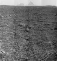
Beautiful horizon...
-------------------- |
|
|
|
|
|
|
Apr 7 2011, 02:39 PM
Post
#144
|
|
|
Forum Contributor Group: Members Posts: 1372 Joined: 8-February 04 From: North East Florida, USA. Member No.: 11 |
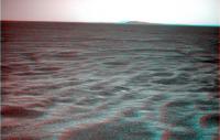
It's just like the approach to the Columbia Hills all over again
|
|
|
|
|
Apr 7 2011, 03:23 PM
Post
#145
|
||
|
Solar System Cartographer Group: Members Posts: 10151 Joined: 5-April 05 From: Canada Member No.: 227 |
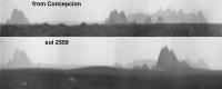
Here's a comparison of the view from Concepcion crater and the view now (from Stu's post above), with a 10x stretch of course.
Phil
-------------------- ... because the Solar System ain't gonna map itself.
Also to be found posting similar content on https://mastodon.social/@PhilStooke Maps for download (free PD: https://upload.wikimedia.org/wikipedia/comm...Cartography.pdf NOTE: everything created by me which I post on UMSF is considered to be in the public domain (NOT CC, public domain) |
|
|
|
|
|
|
Apr 7 2011, 04:59 PM
Post
#146
|
||
|
Solar System Cartographer Group: Members Posts: 10151 Joined: 5-April 05 From: Canada Member No.: 227 |
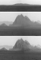
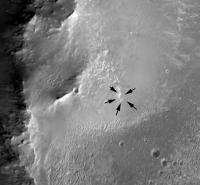
And closing in on Cape Tribulation, there's a crater on its slope that I had not noticed before, though it was probably visible a long way back.
Phil
-------------------- ... because the Solar System ain't gonna map itself.
Also to be found posting similar content on https://mastodon.social/@PhilStooke Maps for download (free PD: https://upload.wikimedia.org/wikipedia/comm...Cartography.pdf NOTE: everything created by me which I post on UMSF is considered to be in the public domain (NOT CC, public domain) |
|
|
|
|
|
|
Apr 7 2011, 06:53 PM
Post
#147
|
|
|
Senior Member Group: Moderator Posts: 4279 Joined: 19-April 05 From: .br at .es Member No.: 253 |
Could it be a JPEG artifact? I can't see it on the HiRISE pics.
 WRT today's drive, I have no time to work on the map but I checked the "telemetry" and Opportunity covered around 140m today! Let's keep this pace. |
|
|
|
|
Apr 7 2011, 07:08 PM
Post
#148
|
||
|
Solar System Cartographer Group: Members Posts: 10151 Joined: 5-April 05 From: Canada Member No.: 227 |
This link:
http://www.unmannedspaceflight.com/index.p...st&id=23696 to one of Stu's images also shows it - so not an artifact, I'm pretty sure. I also tried to match it with HiRISE, and still not sure, but I'm still thinking about it. The crater it could be seems a bit off where I would expect it.
EDIT - should be about here... subdued, and facing the sun so no shadow in it...? Maybe I'll say it's not a crater but various patches of rock. Phil -------------------- ... because the Solar System ain't gonna map itself.
Also to be found posting similar content on https://mastodon.social/@PhilStooke Maps for download (free PD: https://upload.wikimedia.org/wikipedia/comm...Cartography.pdf NOTE: everything created by me which I post on UMSF is considered to be in the public domain (NOT CC, public domain) |
|
|
|
|
|
|
Apr 7 2011, 07:40 PM
Post
#149
|
|
|
Senior Member Group: Members Posts: 3516 Joined: 4-November 05 From: North Wales Member No.: 542 |
I don't know if it helps with that crater, but here's the link back to Nirgal's 3Ds of Tribulation: http://www.unmannedspaceflight.com/index.p...st&p=156417
|
|
|
|
|
Apr 7 2011, 08:43 PM
Post
#150
|
|
|
Solar System Cartographer Group: Members Posts: 10151 Joined: 5-April 05 From: Canada Member No.: 227 |
Interesting! I forgot about that. Looks like my feature shows up better on that - the last one of the set.
Phil -------------------- ... because the Solar System ain't gonna map itself.
Also to be found posting similar content on https://mastodon.social/@PhilStooke Maps for download (free PD: https://upload.wikimedia.org/wikipedia/comm...Cartography.pdf NOTE: everything created by me which I post on UMSF is considered to be in the public domain (NOT CC, public domain) |
|
|
|
|

|
Lo-Fi Version | Time is now: 26th April 2024 - 10:07 AM |
|
RULES AND GUIDELINES Please read the Forum Rules and Guidelines before posting. IMAGE COPYRIGHT |
OPINIONS AND MODERATION Opinions expressed on UnmannedSpaceflight.com are those of the individual posters and do not necessarily reflect the opinions of UnmannedSpaceflight.com or The Planetary Society. The all-volunteer UnmannedSpaceflight.com moderation team is wholly independent of The Planetary Society. The Planetary Society has no influence over decisions made by the UnmannedSpaceflight.com moderators. |
SUPPORT THE FORUM Unmannedspaceflight.com is funded by the Planetary Society. Please consider supporting our work and many other projects by donating to the Society or becoming a member. |
|