Opportunity Route Map |

  |
Opportunity Route Map |
 Aug 1 2006, 08:04 PM Aug 1 2006, 08:04 PM
Post
#1726
|
|
|
Member  Group: Members Posts: 470 Joined: 24-March 04 From: Finland Member No.: 63 |
Over how? Manouvering around Victoria is going to be a major task. The best slopes for sun bathing are on the other side of the crater, and that's at least 1250m driving around half of the crater. If they decide to go inside the crater elsewhere, i doubt the best parts are at the first spot we arrive in.
So it's lots more route maps to draw, I reckon. -------------------- Antti Kuosmanen
|
 |
 
|
|
Aug 1 2006, 08:59 PM
Post
#1727
|
|
|
Senior Member Group: Members Posts: 2918 Joined: 14-February 06 From: Very close to the Pyrénées Mountains (France) Member No.: 682 |
Oups! I thought I was in "going South to Victoria" !!!
So, YES, I expect much more Route Maps  . Even Tesheiner is having vacations so he'll be able to track Oppy for another year and more. . Even Tesheiner is having vacations so he'll be able to track Oppy for another year and more.
-------------------- |
|
|
|
|
Aug 1 2006, 09:56 PM
Post
#1728
|
|
|
Junior Member Group: Members Posts: 29 Joined: 12-February 04 Member No.: 29 |
QUOTE (akuo @ Aug 1 2006, 03:04 PM)  Over how? Manouvering around Victoria is going to be a major task. The best slopes for sun bathing are on the other side of the crater, and that's at least 1250m driving around half of the crater. If they decide to go inside the crater elsewhere, i doubt the best parts are at the first spot we arrive in. So it's lots more route maps to draw, I reckon. By the time opportunity reaches victoria rim, the deep of winter will be over - so no more need to achieve sun-facing slopes. |
|
|
|
|
Aug 1 2006, 10:57 PM
Post
#1729
|
|
|
Senior Member Group: Members Posts: 1636 Joined: 9-May 05 From: Lima, Peru Member No.: 385 |
QUOTE (dot.dk @ Jul 31 2006, 07:31 PM) Now Tomorrow is  CODE 896 p0666.03 0 0 0 0 0 0 navcam_6x1_az_108_3_bpp 896 p1151.04 0 0 0 0 0 0 front_hazcam_idd_unstow_doc 896 p1154.01 0 0 0 0 0 0 front_hazcam_idd_unstow_doc 896 p1205.08 0 0 0 0 0 0 front_haz_penultimate_0.5_bpp_pri17 896 p1212.09 0 0 0 0 0 0 front_haz_ultimate_2_bpp_pri15 896 p1305.07 0 0 0 0 0 0 rear_haz_penultimate_0.5bpp_pri17 896 p1311.07 0 0 0 0 0 0 rear_haz_ultimate_1_bpp_crit15 896 p1375.01 0 0 0 0 0 0 rear_hazcam_0.5bpp_pri_41 896 p1585.00 0 0 0 0 0 0 navcam_cloud_4x1_dwnsmp_RVRAz_calstart 896 Total 0 0 0 0 0 0 Good By that time, when I checked it was blank!! The navigation direction would be close to South East (108 degrees)? That means Oppy will go toward the southern part of Victoria Crater. No more close up on Beagle Crater.  Rodolfo |
|
|
|
|
Aug 1 2006, 11:27 PM
Post
#1730
|
|
|
Senior Member Group: Members Posts: 2998 Joined: 30-October 04 Member No.: 105 |
QUOTE The navigation direction would be close to South East (108 degrees)? That means Oppy will go.. No. An azimuth108 degrees is just south of east and goes nowhere immediately useful with respect to Victoria. I'm thinking that she's maneuvering around Beagle, or might possibly be setting up to drive onto the ejecta blanket, AKA their "sand sheet". Attached is a clip from the Sol 891 Route Map the red arrowed line is at 108 degrees. --Bill -------------------- |
|
|
|
|
Aug 1 2006, 11:40 PM
Post
#1731
|
|
|
Member Group: Members Posts: 100 Joined: 20-May 06 Member No.: 780 |
QUOTE (Bill Harris @ Aug 1 2006, 07:27 PM) No. An azimuth108 degrees is just south of east and goes nowhere immediately useful with respect to Victoria. I'm thinking that she's maneuvering around Beagle, or might possibly be setting up to drive onto the ejecta blanket, AKA their "sand sheet". My guess is perhaps 10-15 meters in that direction, with a dogleg to the northeast. If they're going to try for a peek into Beagle, that would put the first attempt on the south or southeast side of the crater. |
|
|
|
|
Aug 1 2006, 11:56 PM
Post
#1732
|
|
 Senior Member Group: Moderator Posts: 2262 Joined: 9-February 04 From: Melbourne - Oz Member No.: 16 |
Note that 108 degrees doen't really mean anything useful to the drive direction.
It's the centre azimuth of the navcam pan, but that pan is 6 frames wide thats ~220 degrees. It *may* indicate the direction of Beagle *after* the drive, meaning we're heading toward the west side - but I wouldn't put any money on it from that navcam pointing! James -------------------- |
|
|
|
|
Aug 2 2006, 12:24 AM
Post
#1733
|
|
|
Senior Member Group: Moderator Posts: 2262 Joined: 9-February 04 From: Melbourne - Oz Member No.: 16 |
Some tracking data is up for 896!
We've gone NE - straight toward Beagle. About 17m - that should put the rim within 5m or so!!
-------------------- |
|
|
|
|
Aug 2 2006, 02:42 AM
Post
#1734
|
||
|
Senior Member Group: Moderator Posts: 2262 Joined: 9-February 04 From: Melbourne - Oz Member No.: 16 |
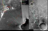
Route map for Sol 896.
Attached thumbnail(s)
-------------------- |
|
|
|
|
|
|
Aug 2 2006, 02:25 PM
Post
#1735
|
|
|
Senior Member Group: Members Posts: 1636 Joined: 9-May 05 From: Lima, Peru Member No.: 385 |
QUOTE (jamescanvin @ Aug 1 2006, 06:56 PM) Note that 108 degrees doen't really mean anything useful to the drive direction. It's the centre azimuth of the navcam pan, but that pan is 6 frames wide thats ~220 degrees. It *may* indicate the direction of Beagle *after* the drive, meaning we're heading toward the west side - but I wouldn't put any money on it from that navcam pointing! James James, Good hint! 
|
|
|
|
|
Aug 4 2006, 02:49 AM
Post
#1736
|
||
|
Senior Member Group: Moderator Posts: 2262 Joined: 9-February 04 From: Melbourne - Oz Member No.: 16 |
Sol 898 route map.
A short drive to position Oppy nicely on the 7 o'clock ray for IDD work. P.S I'm escaping from Sydneys winter tomorrow, off to the tropics, so this will be my last route map till the 16th, by which time Tesh should be back anyway. James -------------------- |
|
|
|
|
|
|
Aug 4 2006, 04:39 AM
Post
#1737
|
|
 Senior Member Group: Members Posts: 2228 Joined: 1-December 04 From: Marble Falls, Texas, USA Member No.: 116 |
I hope you have an enjoyable respite, and thanks for expertly filling the void at a time of need.
-------------------- ...Tom
I'm not a Space Fan, I'm a Space Exploration Enthusiast. |
|
|
|
| Guest_Sunspot_* |
Aug 4 2006, 11:31 AM
Post
#1738
|
|
Guests |
I wonder if they'll drive further to the right/east? on that map - to reach that patch of bedrock before attempting to drive south to Victoria?
|
|
|
|
|
Aug 4 2006, 05:07 PM
Post
#1739
|
|
|
Solar System Cartographer Group: Members Posts: 10145 Joined: 5-April 05 From: Canada Member No.: 227 |
My guess is that Opportunity will head east towards the north rim instead of southeast to the SW rim of Victoria - better tilt and little or no climb involved.
I will keep the map going, since James is off to throw another shrimp on the barbie. Give my regards to Barry McKenzie, James... Phil -------------------- ... because the Solar System ain't gonna map itself.
Also to be found posting similar content on https://mastodon.social/@PhilStooke NOTE: everything created by me which I post on UMSF is considered to be in the public domain (NOT CC, public domain) |
|
|
|
|
Aug 4 2006, 07:22 PM
Post
#1740
|
|
 Senior Member Group: Members Posts: 4246 Joined: 17-January 05 Member No.: 152 |
My own guess of the best approach to VC would be directly SE, getting as quickly as possible out of the ripples and onto the apparently smooth "sand sheet". Maybe somebody could start a "what route will they take" poll!
 A million thanks, Phil, for taking over the map! If I might offer a suggestion, could you add a few names to the map - in particular the names gamma, delta, epsilon from the route map in algorimancer's post here. We've used these names a few times already, and if no one has any objections, I suggest using these names until more official names "come down from the mountain". It certainly beats referring to "the closest crater to the south of Beagle" and the like! Another possibility would be to include the name "Española", from the latest update, which appears to refer to the "transitional" area between Beagle, Delta, and the southwest extension of the Beagle highway. |
|
|
|
|

|
Lo-Fi Version | Time is now: 18th April 2024 - 01:19 AM |
|
RULES AND GUIDELINES Please read the Forum Rules and Guidelines before posting. IMAGE COPYRIGHT |
OPINIONS AND MODERATION Opinions expressed on UnmannedSpaceflight.com are those of the individual posters and do not necessarily reflect the opinions of UnmannedSpaceflight.com or The Planetary Society. The all-volunteer UnmannedSpaceflight.com moderation team is wholly independent of The Planetary Society. The Planetary Society has no influence over decisions made by the UnmannedSpaceflight.com moderators. |
SUPPORT THE FORUM Unmannedspaceflight.com is funded by the Planetary Society. Please consider supporting our work and many other projects by donating to the Society or becoming a member. |
|