Exploring Mt Sharp north of the dunes - Part 1: Beyond Pahrump Hills, Site 45-50, Sol 923-1147, March 12-October 28, 2015 |

  |
Exploring Mt Sharp north of the dunes - Part 1: Beyond Pahrump Hills, Site 45-50, Sol 923-1147, March 12-October 28, 2015 |
| Guest_Steve5304_* |
 Sep 6 2015, 04:11 AM Sep 6 2015, 04:11 AM
Post
#751
|
|
Guests |
QUOTE (nprev @ Sep 6 2015, 04:51 AM)  They probably are; gypsum veins have been found by Oppy and Curiosity before. There was water percolation through bedrock in many places. Most of what we see is a lot older than most places on Earth, though; billions instead of millions. Erosion moves exceedingly slowly here. well the gypsum is in a flow pattern downstream. the plaster of paris only reveals itself in the presence of.water . This place on the planet had ALOT of water... |
 |
 
|
|
Sep 6 2015, 04:29 PM
Post
#752
|
||
 Member  Group: Members Posts: 334 Joined: 11-December 12 From: The home of Corby Crater (Corby-England) Member No.: 6783 |
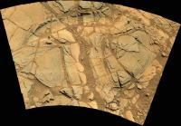
MastCam mosaic from Sol1095, (not sure of target name)
|
|
|
|
|
|
|
Sep 7 2015, 01:46 AM
Post
#753
|
|
 Senior Member Group: Members Posts: 2425 Joined: 30-January 13 From: Penang, Malaysia. Member No.: 6853 |
|
|
|
|
|
Sep 7 2015, 04:55 AM
Post
#754
|
|
|
Senior Member Group: Members Posts: 1043 Joined: 17-February 09 Member No.: 4605 |
QUOTE (nprev @ Sep 6 2015, 04:51 AM) ..... Erosion moves exceedingly slowly here. More accurately, erosion moves exceedingly slowly here now days. In the past this must have been a very dynamic environment with plenty of that universal solvent, water. In the absence of plate tectonics building and sculpting a sedimentary formation like mount Sharp won't happen in a benign environment. |
|
|
|
| Guest_Actionman_* |
Sep 7 2015, 11:03 AM
Post
#755
|
|
Guests |
... erosion exceedingly thorough with out apparent annihilation.
|
|
|
|
|
Sep 8 2015, 01:35 AM
Post
#756
|
|
|
Member Group: Members Posts: 306 Joined: 4-October 14 Member No.: 7273 |
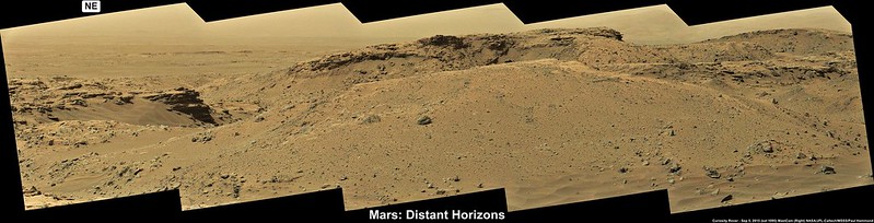
QUOTE (PaulH51 @ Sep 6 2015, 07:46 PM) Another R-MastCam mosaic from sol 1095 I believe the big ridge at center is Grey Wolf Peak. Cliff on the left side might be the rear flank of Mt. Stimson or Mt. Siyeh. |
|
|
|
|
Sep 8 2015, 03:47 AM
Post
#757
|
|
|
Senior Member Group: Members Posts: 2425 Joined: 30-January 13 From: Penang, Malaysia. Member No.: 6853 |
|
|
|
|
|
Sep 8 2015, 05:02 AM
Post
#758
|
|
|
Senior Member Group: Members Posts: 2425 Joined: 30-January 13 From: Penang, Malaysia. Member No.: 6853 |
QUOTE (jccwrt @ Sep 8 2015, 09:35 AM) I believe the big ridge at center is Grey Wolf Peak. Cliff on the left side might be the rear flank of Mt. Stimson or Mt. Siyeh. Looking at Phil's maps, that sounds like a good call... I'd probably favour Siyeh for the other peak 
|
|
|
|
|
Sep 8 2015, 09:10 PM
Post
#759
|
|
|
Member Group: Members Posts: 866 Joined: 15-March 05 From: Santa Cruz, CA Member No.: 196 |
QUOTE (algorithm @ Sep 6 2015, 09:29 AM) MastCam mosaic from Sol1095, (not sure of target name) Nice work! algorithm's stitch stitch gives context to the two curious and seemingly related bar-like features tht appear to contain coarser grains and are displaced across what to my untrained eye looks like an apparent fault slip in this sol1095 image... interpretations anyone? |
|
|
|
|
Sep 8 2015, 11:45 PM
Post
#760
|
|
|
Senior Member Group: Members Posts: 2425 Joined: 30-January 13 From: Penang, Malaysia. Member No.: 6853 |
QUOTE (atomoid @ Sep 9 2015, 05:10 AM) Interpretations anyone? I'll leave that to the experts But it is impressiveMeanwhile we dont have all the NavCam images yet, but these 5 frames (L-NavCam, sol 1098) give us an idea of the terrain in new location. Roughly assembled in MS ICE. The drive appears to have been cut short of the planned distance. Maybe the rover spotted the outcrops to the right (inside Bridger Basin) and fancied a closer look at them If not, there is some better driving terrain to the south and then west around the basin.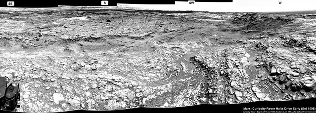 Original (3841 x 1382) LINK Edit : Curiosity Mission Update from Ken Herkenhoff, Sol 1099: Driving again LINK QUOTE MSL did well over the long weekend, except that the Sol 1098 drive was halted after 13 meters of the planned 25 meters because the rover could not confirm that the path ahead was safe. So the plan for the Sol 1099 drive is essentially to complete the rest of the previously planned drive. The only significant problem I've had to grapple with today as SOWG Chair is that the last 5 relays of data through MRO have returned significantly less data than expected; if this problem continues, we will barely receive enough data to plan another drive on Sol 1100. Fortunately, the MRO team understands the problem and knows how to correct it, and there is a good chance that we will receive all the data we need in time for planning tomorrow morning. This situation reminds me of how much we depend on the Mars orbiters and the teams that operate them, and to thank them for their continued support of the MSL mission.
Before the Sol 1099 drive, we have time to acquire ChemCam and Mastcam observations of "Mission Creek" and "Chamberlain," plus MastCam mosaics of "Bridger Basin," "Hackley Point," and "Police Creek." The rover will wake up early on the morning of Sol 1100 to acquire a big stereo mosaic of the far wall of Bridger Basin, because the illumination will be better early in the morning. Mastcam will also take a 360-degree panorama with the left camera. |
|
|
|
|
Sep 9 2015, 06:58 AM
Post
#761
|
|
|
Senior Member Group: Members Posts: 2425 Joined: 30-January 13 From: Penang, Malaysia. Member No.: 6853 |
Sol 1098 R-NavCam in MS ICE. Stitching at the horizon is poor, but the rest should be OK. Great view....
 Link to full size LINK |
|
|
|
|
Sep 9 2015, 09:59 AM
Post
#762
|
||
|
Senior Member Group: Members Posts: 2819 Joined: 22-April 05 From: Ridderkerk, Netherlands Member No.: 353 |
The Navcam L panoramic view on Sol 1098.
Jan van Driel
|
|
|
|
|
|
|
Sep 9 2015, 01:30 PM
Post
#763
|
||
|
Solar System Cartographer Group: Members Posts: 10149 Joined: 5-April 05 From: Canada Member No.: 227 |
Jan's panorama in circular form - for identification of distant features, this projection puts them at the correct azimuth (roughly - I'm only aligning it by eye here).
Paul - assuming your mosaic work uses manually identified tie points, try to make sure there is one on the horizon at each image overlap, and your horizon will be fixed. Phil
-------------------- ... because the Solar System ain't gonna map itself.
Also to be found posting similar content on https://mastodon.social/@PhilStooke NOTE: everything created by me which I post on UMSF is considered to be in the public domain (NOT CC, public domain) |
|
|
|
|
|
|
Sep 9 2015, 03:57 PM
Post
#764
|
||
|
Senior Member Group: Members Posts: 2819 Joined: 22-April 05 From: Ridderkerk, Netherlands Member No.: 353 |
and the Navcam L view on Sol 1099.
Jan van Driel
|
|
|
|
|
|
|
Sep 9 2015, 04:15 PM
Post
#765
|
||
|
Solar System Cartographer Group: Members Posts: 10149 Joined: 5-April 05 From: Canada Member No.: 227 |
and the circular view of the same view on Sol 1099! Great view of the cliffs of Bridger Basin.
Phil
-------------------- ... because the Solar System ain't gonna map itself.
Also to be found posting similar content on https://mastodon.social/@PhilStooke NOTE: everything created by me which I post on UMSF is considered to be in the public domain (NOT CC, public domain) |
|
|
|
|
|
|

|
Lo-Fi Version | Time is now: 22nd April 2024 - 11:54 PM |
|
RULES AND GUIDELINES Please read the Forum Rules and Guidelines before posting. IMAGE COPYRIGHT |
OPINIONS AND MODERATION Opinions expressed on UnmannedSpaceflight.com are those of the individual posters and do not necessarily reflect the opinions of UnmannedSpaceflight.com or The Planetary Society. The all-volunteer UnmannedSpaceflight.com moderation team is wholly independent of The Planetary Society. The Planetary Society has no influence over decisions made by the UnmannedSpaceflight.com moderators. |
SUPPORT THE FORUM Unmannedspaceflight.com is funded by the Planetary Society. Please consider supporting our work and many other projects by donating to the Society or becoming a member. |
|