CRISM Corner |

CRISM Corner |
| Guest_AlexBlackwell_* |
 Sep 28 2006, 02:14 AM Sep 28 2006, 02:14 AM
Post
#1
|
|
Guests |
APL-Built Mineral-Mapping Imager Begins Mission at Mars
JHU/APL For Immediate Release September 27, 2006 See also A.J.S. Rayl's story at TPS. EDIT: I changed the topic title because, as I understand it from the press release, the cover was opened, not jettisoned. This post has been edited by AlexBlackwell: Sep 28 2006, 04:48 PM |
 |
 
|
 |
|
Sep 28 2006, 04:54 AM
Post
#2
|
|
|
Junior Member  Group: Members Posts: 50 Joined: 7-July 06 From: Selden, NY Member No.: 960 |
woohoo!
Vis/Near-IR spectra at roughly THEMIS Vis (~17 m) spatial resolution. This will be an awesome mission. I'm psyched to see the first results. |
|
|
|
|
Sep 28 2006, 02:55 PM
Post
#3
|
|
|
Member Group: Members Posts: 163 Joined: 16-March 05 From: Oakville, Ontario, Canada Member No.: 201 |
There are too many cool things with MRO

|
|
|
|
| Guest_AlexBlackwell_* |
Sep 29 2006, 07:29 PM
Post
#4
|
|
Guests |
As pointed out by Rakhir in another thread:
New Spectrometer Begins Its Global Map of Mars September 29, 2006 |
|
|
|
| Guest_AlexBlackwell_* |
Oct 5 2006, 07:21 PM
Post
#5
|
|
Guests |
I'm starting this thread as a respository for all things CRISM
 I'll merge the other thread dealing with CRISM's cover succesfully opening with this one. I'll merge the other thread dealing with CRISM's cover succesfully opening with this one.And as Doug first glogged yesterday, CRISM has released its "First 'Targeted' Observation of Mars." |
|
|
|
|
Dec 10 2006, 02:53 PM
Post
#6
|
|
 Member Group: Members Posts: 267 Joined: 5-February 06 Member No.: 675 |
Given the silence of late from the CRISM folks at Johns Hopkins APL, might it be worthwhile to contact some of the staff there to see what can be done to improve their public visibility.
Hopkins is a first rate school, (it hosts the Hubble STScI on its campus) and could get some good press if the folks at APL got their act together. Steve |
|
|
|
|
Dec 11 2006, 02:48 AM
Post
#7
|
|
|
Member Group: Members Posts: 234 Joined: 8-May 05 Member No.: 381 |
QUOTE (Steve @ Dec 10 2006, 08:53 AM)  Given the silence of late from the CRISM folks at Johns Hopkins APL, might it be worthwhile to contact some of the staff there to see what can be done to improve their public visibility. Hopkins is a first rate school, (it hosts the Hubble STScI on its campus) and could get some good press if the folks at APL got their act together. Steve Processing CRISM data is enormously more complicated than for HiRISE. A major task is separating the true spectra of the Martian surface from atmospheric spectral contributions. It's the kind of thing they'll probably be refining for years in mathematical theories. That said, I agree that they should be making a greater effort to share their progress with the public, even if it means releasing only intermediate-stage data. A HiBlog style blog would be most welcome. |
|
|
|
| Guest_AlexBlackwell_* |
Dec 11 2006, 06:57 PM
Post
#8
|
|
Guests |
QUOTE (Steve @ Dec 10 2006, 04:53 AM) Given the silence of late from the CRISM folks at Johns Hopkins APL, might it be worthwhile to contact some of the staff there to see what can be done to improve their public visibility. As monitorlizard noted, processing the CRISM spectra is vastly more different than providing web-ready HiRISE imagery. Note that TES and THEMIS IR releases lagged, too. NASA-funded planetary science missions usually publish their initial results (traditionally in Science) 5-6 months after the data acquisition begins. I wouldn't be at all surprised if MRO follows the same path. |
|
|
|
|
Dec 11 2006, 07:36 PM
Post
#9
|
|
|
Member Group: Members Posts: 428 Joined: 21-August 06 From: Northern Virginia Member No.: 1062 |
QUOTE (AlexBlackwell @ Dec 11 2006, 11:57 AM) As monitorlizard noted, processing the CRISM spectra is vastly more different than providing web-ready HiRISE imagery. Note that TES and THEMIS IR releases lagged, too. NASA-funded planetary science missions usually publish their initial results (traditionally in Science) 5-6 months after the data acquisition begins. I wouldn't be at all surprised if MRO follows the same path. HiRISE is relatively easy to process compared to CRISM. HiRISE will eventually reach the point of releasing images as soon as the processing is complete, but that might still be a while. It should be among the fastest missions to release processed data in history. We just aren't quite there yet... |
|
|
|
|
Dec 12 2006, 09:36 AM
Post
#10
|
|
|
Member Group: Members Posts: 234 Joined: 8-May 05 Member No.: 381 |
QUOTE (AlexBlackwell @ Dec 11 2006, 12:57 PM) As monitorlizard noted, processing the CRISM spectra is vastly more different than providing web-ready HiRISE imagery. Note that TES and THEMIS IR releases lagged, too. NASA-funded planetary science missions usually publish their initial results (traditionally in Science) 5-6 months after the data acquisition begins. I wouldn't be at all surprised if MRO follows the same path. I don't have any inside knowledge, but I would bet that the first major appearance of CRISM findings will be in the 2007 Lunar & Planetary Science Conference abstacts, to be online late January or early February. Could be substantial, as abstacts can be two pages in length. |
|
|
|
|
Dec 12 2006, 09:42 AM
Post
#11
|
|
|
Member Group: Members Posts: 234 Joined: 8-May 05 Member No.: 381 |
Abstact should be abstract. I guess if I were a pirate I would use rrrrrrrr more often.
|
|
|
|
| Guest_AlexBlackwell_* |
Dec 13 2006, 07:25 PM
Post
#12
|
|
Guests |
|
|
|
|
|
Dec 14 2006, 09:46 AM
Post
#13
|
|
|
Member Group: Members Posts: 362 Joined: 13-April 06 From: Malta Member No.: 741 |
Roughly how long does it take for water interacting with basalt to produce clay?
|
|
|
|
|
Dec 14 2006, 06:42 PM
Post
#14
|
|
|
Member Group: Members Posts: 688 Joined: 20-April 05 From: Sweden Member No.: 273 |
QUOTE (Julius @ Dec 14 2006, 10:46 AM) Roughly how long does it take for water interacting with basalt to produce clay? It varies a lot depending on climate. In wet tropical areas volcanic rock weathers to (incidentally quite fertile) clayey soils in a few centuries while on Iceland lavas that are more than 1,000 years old are still unvegetated and almost unweathered. Even under the warmest and wettest conditions conceivable on early Mars I would guess millenia would be required to create any appreciable amounts of clay. tty |
|
|
|
|
Dec 14 2006, 09:17 PM
Post
#15
|
|
|
Member Group: Members Posts: 362 Joined: 13-April 06 From: Malta Member No.: 741 |
Correct me if I'm wrong ,Nili fossae like other fracture systems,seem to be associated with tectonic areas,in this case with Syrtis Major. Would it be right to assume that water flowing along this fracture system would have been water runoff associated with volcanic eruptions from Syrtis major?Certainly that would not mean that the presence of clay formations in this area would mean that there was an ongoing hydrological cycle on Mars!Right or wrong?I am assuming that volcanic eruptions were episodic and thus water flowing within the fractures would have been episodic rather than water pooling for long periods of time!Any comments regarding this matter would be much appreciated.
|
|
|
|
|
Dec 18 2006, 04:01 PM
Post
#16
|
|
|
Junior Member Group: Members Posts: 50 Joined: 7-July 06 From: Selden, NY Member No.: 960 |
At the AGU meeting last week, CRISM PI Scott Murchie showed CRISM data from Nili Fossae and Mawrth Vallis, which confirm the OMEGA findings of clays, but at much higher spatial resolution. The real strength of CRISM is going to be the ability to correlate spectral features with distinct geologic units at ~20 m/pix. In addition Scott also showed ice-rich and ice-poor regions in the polar layered deposits. Team members Frank Seelos and Kim Seelos also presented posters showing data from the CRISM global coverage mode, focusing on the north polar cap and potential Phoenix landing sites. Not much to report in terms of composition there yet.
|
|
|
|
| Guest_AlexBlackwell_* |
Dec 18 2006, 07:43 PM
Post
#17
|
|
Guests |
QUOTE (tglotch @ Dec 18 2006, 06:01 AM) At the AGU meeting last week, CRISM PI Scott Murchie showed CRISM data from Nili Fossae and Mawrth Vallis, which confirm the OMEGA findings of clays... I wish CRISM would have released the Mawrth Vallis data, too. And I'm assuming CRISM's resolution is a little better than this
|
|
|
|
|
Dec 18 2006, 10:11 PM
Post
#18
|
|
|
Junior Member Group: Members Posts: 50 Joined: 7-July 06 From: Selden, NY Member No.: 960 |
|
|
|
|
| Guest_AlexBlackwell_* |
Dec 22 2006, 08:26 PM
Post
#19
|
|
Guests |
There was CRISM release today: PIA09101: Seasonal Frost in Terra Sirenum.
|
|
|
|
|
Dec 22 2006, 08:45 PM
Post
#20
|
|
|
Member Group: Members Posts: 267 Joined: 5-February 06 Member No.: 675 |
Should we be concerned about the noise in the green (1.45uM CO2 absorption) band?
Either it was a weak, therefore noisy, signal or there are some instrumentation problems with CRISM  . .Steve |
|
|
|
|
Dec 22 2006, 08:58 PM
Post
#21
|
|
|
Member Group: Members Posts: 258 Joined: 22-December 06 Member No.: 1503 |
QUOTE (Steve @ Dec 22 2006, 02:45 PM) Should we be concerned about the noise in the green (1.45uM CO2 absorption) band? Either it was a weak, therefore noisy, signal or there are some instrumentation problems with CRISM .Steve Just a thought, Could the problem be somehow related to the recent solar activity? And if it is, might it be a temporary problem? |
|
|
|
|
Dec 22 2006, 09:11 PM
Post
#22
|
|
 Senior Member Group: Members Posts: 3648 Joined: 1-October 05 From: Croatia Member No.: 523 |
There's probably nothing wrong with CRISM. You can't expect s/n ratios equal to framing cameras because spectrometers split the incoming light into a huge nuber of different wavelengths that are separately detected. The total energy per wavelength slice is thus reduced. There's also the way the spectrometers are built that they can be susceptible to noise (such as lower quantum efficiencies for certain wavelengths, ccd damage, etc). If you want to see what ugly data really looks like, take a look at Cassini's VIMS visual channel products.
-------------------- |
|
|
|
| Guest_AlexBlackwell_* |
Feb 12 2007, 06:00 PM
Post
#23
|
|
Guests |
A Fresh Crater Drills to Tharsis Bedrock
MRO CRISM Release February This post has been edited by AlexBlackwell: Feb 12 2007, 09:06 PM |
|
|
|
| Guest_AlexBlackwell_* |
Feb 12 2007, 07:37 PM
Post
#24
|
|
Guests |
Note that the above release has been now delayed until tomorrow, though the link still works.
|
|
|
|
| Guest_AlexBlackwell_* |
Feb 15 2007, 07:30 PM
Post
#25
|
|
Guests |
|
|
|
|
|
Feb 16 2007, 02:06 PM
Post
#26
|
|
|
Senior Member Group: Members Posts: 3516 Joined: 4-November 05 From: North Wales Member No.: 542 |
Really beautiful images and a fascinating comparison.
|
|
|
|
| Guest_AlexBlackwell_* |
Feb 21 2007, 04:16 PM
Post
#27
|
|
Guests |
|
|
|
|
| Guest_AlexBlackwell_* |
Feb 22 2007, 01:41 AM
Post
#28
|
|
Guests |
I'm slipping. I missed this general CRISM press release a few days ago: Mineral Mapper Marks 100 Days at Mars.
|
|
|
|
| Guest_AlexBlackwell_* |
Feb 23 2007, 05:26 PM
Post
#29
|
|
Guests |
|
|
|
|
| Guest_AlexBlackwell_* |
Feb 27 2007, 06:53 PM
Post
#30
|
|
Guests |
|
|
|
|
|
Apr 1 2007, 02:16 AM
Post
#31
|
|
|
Member Group: Members Posts: 267 Joined: 5-February 06 Member No.: 675 |
There are two more releases in March:
03-16-2007 South Polar Cryptic Terrain in Early Spring 03-27-2007 Defrosting of Russell Crater Dunes There's also a nice gallery page. Steve |
|
|
|
| Guest_AlexBlackwell_* |
May 18 2007, 06:17 PM
Post
#32
|
|
Guests |
|
|
|
|
|
Jun 12 2007, 11:39 AM
Post
#33
|
|
|
Member Group: Members Posts: 234 Joined: 8-May 05 Member No.: 381 |
The CRISM website (crism.jhuapl.edu) has a cool new feature called CRISM View that allows anyone to see where CRISM is over Mars in real time and what observations it is going to make next. Some of its features:
MRO Mars Ground Track, showing current postion over Mars CRISM Information Table, showing current instrument settings Next Scheduled CRISM Observations, a table covering the next few days Current CRISM View and more CRISM View is updated every Sunday at midnight (probably Eastern time) To run this, you have to install Java 2 Runtime Environment 1.5 (14.2 MB) and Java 3D 1.4 (2.76MB). This is for PC/Windows. These are available at the CRISM website. |
|
|
|
| Guest_AlexBlackwell_* |
Jun 12 2007, 09:54 PM
Post
#34
|
|
Guests |
|
|
|
|
|
Jun 13 2007, 12:55 AM
Post
#35
|
|
 Junior Member Group: Members Posts: 76 Joined: 4-June 07 From: United Kingdom Member No.: 2288 |
Well, thanks for that. Congratulations to the team who coded the viewer!
I'm still working this out, but is that real-time data or just displayed running from the spice kernels and related data ? Alexblackwell, that's a very nice multi spectral map. Will the colour and multi spectral image strips be displayed in a gallery format like the HiRise images ? MouseOnMars -------------------- |
|
|
|
| Guest_AlexBlackwell_* |
Jun 27 2007, 05:39 PM
Post
#36
|
|
Guests |
CRISM Data Available on NASAs Online Archive
June 27, 2007 |
|
|
|
|
Jun 27 2007, 05:48 PM
Post
#37
|
|
 Administrator Group: Admin Posts: 5172 Joined: 4-August 05 From: Pasadena, CA, USA, Earth Member No.: 454 |
This interface appears to include Web access to CTX images too
 --Emily -------------------- My website - My Patreon - @elakdawalla on Twitter - Please support unmannedspaceflight.com by donating here.
|
|
|
|
|
Jun 27 2007, 06:04 PM
Post
#38
|
|
|
Founder Group: Chairman Posts: 14432 Joined: 8-February 04 Member No.: 1 |
And I've just seen that the Marsoweb landing site site has CTX images as well.
too much data Doug |
|
|
|
| Guest_AlexBlackwell_* |
Jun 27 2007, 07:26 PM
Post
#39
|
|
Guests |
For those who don't have access to the Journal of Geophysical Research-Planets, the recent paper in the Special Collection - Mars Reconnaissance Orbiter Mission and Science Investigations by Murchie et al. describing the CRISM instrument is available here (3.1 Mb PDF reprint).
|
|
|
|
|
Aug 26 2007, 05:36 PM
Post
#40
|
|||
|
Member Group: Members Posts: 267 Joined: 5-February 06 Member No.: 675 |
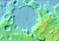
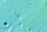
QUOTE (AlexBlackwell @ Jun 27 2007, 12:39 PM) CRISM Data Available on NASAs Online Archive June 27, 2007 I just did some browsing at The PDS Search Page and found the following maps of CRISM data from Gusev and Meridiani areas. Those of you who feel like diving into multispectral data, might find something worth looking at in the neighborhood of Spirit and Opportunity.
Steve |
||
|
|
|
||
|
Aug 26 2007, 08:06 PM
Post
#41
|
|
 Senior Member Group: Members Posts: 3419 Joined: 9-February 04 From: Minneapolis, MN, USA Member No.: 15 |
Are the red dots spurious noise in the data, or do they actually indicate some radical difference in surface composition? And if so, what does red really indicate in this context?
I have to say, from the looks of it, they look like noise to me. But I'd enjoy knowing, one way or the other. -the other Doug -------------------- The trouble ain't that there is too many fools, but that the lightning ain't distributed right. -Mark Twain
|
|
|
|
|
Aug 26 2007, 08:13 PM
Post
#42
|
|
|
Founder Group: Chairman Posts: 14432 Joined: 8-February 04 Member No.: 1 |
I think they're actually the locations of crism observations
Each will link (on the proper site) to the observation. Doug |
|
|
|
|
Aug 27 2007, 05:51 AM
Post
#43
|
|
|
Senior Member Group: Members Posts: 1870 Joined: 20-February 05 Member No.: 174 |
Pics look like laser topo models with the locations of the crism data superimposed.
|
|
|
|
|
Aug 27 2007, 12:42 PM
Post
#44
|
|
|
Member Group: Members Posts: 267 Joined: 5-February 06 Member No.: 675 |
QUOTE (edstrick @ Aug 27 2007, 12:51 AM) Pics look like laser topo models with the locations of the crism data superimposed. Doug and Ed are right, these are just catalog maps of the CRISM data with the locations of the CRISM images superimposed on a shaded relief map. I should have been a bit clearer in my brief note. If you look at the PDS Search Page you can zoom in even closer to resolve the pattern of the CRISM investigations. What intrigues me is the extent of coverage in the Gusev Hills and along what looks like the track of Opportunity running down to Victoria crater. None of this has made its way into the public discussion of the CRISM data. Of course, I'd like to see what some of the geologists on board make of the data itself. Steve |
|
|
|
|
Aug 27 2007, 01:05 PM
Post
#45
|
|
|
Member Group: Members Posts: 267 Joined: 5-February 06 Member No.: 675 |
It turns out there are some recently published abstracts of studies of the CRISM data from Meridiani:
Initial Analyses of CRISM Data over Meridiani Planum. and Gusev: Initial Results from the MRO CRISM in ... Gusev Crater.... Possible Evidence for Iron Sulfates...at Gusev Crater.... From a quick look, they haven't yet looked in detail at the small scale geochemistry in the vicinity of the rovers that CRISM promises to unravel. Steve This post has been edited by Steve: Aug 27 2007, 01:17 PM |
|
|
|
| Guest_AlexBlackwell_* |
Sep 11 2007, 05:30 PM
Post
#46
|
|
Guests |
|
|
|
|
|
Sep 25 2007, 09:49 AM
Post
#47
|
|
|
Founder Group: Chairman Posts: 14432 Joined: 8-February 04 Member No.: 1 |
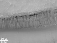
They got it - CRISM of the MGS gullies.
http://crism.jhuapl.edu/gallery/featuredIm...amp;image_id=95 It's looking like dust slides. Doug |
|
|
|
|
Sep 25 2007, 10:24 AM
Post
#48
|
|
|
Senior Member Group: Members Posts: 3648 Joined: 1-October 05 From: Croatia Member No.: 523 |
QUOTE (djellison @ Sep 25 2007, 11:49 AM) It's looking like dust slides. Well, it was fun while it lasted. -------------------- |
|
|
|
|
Sep 25 2007, 01:16 PM
Post
#49
|
|
 Member Group: Members Posts: 593 Joined: 20-April 05 Member No.: 279 |
QUOTE (ugordan @ Sep 25 2007, 11:24 AM) Well, it was fun while it lasted. Is it over? I don't see how "Dust slides" per se answer questions relating to the face of slopes, which I believe tend to show a preference in terms of their bearing. And if these slides were caused by liquid water, then that water would evaporate quickly from the scene. So the surface materials brought down by undermining and slip wouldn't have the chance to be modified by salts in the water, and might still chemically resemble dry surface materials from around the area... Andy, needing more evidence one way or another. |
|
|
|
|
Sep 25 2007, 01:26 PM
Post
#50
|
|
|
Founder Group: Chairman Posts: 14432 Joined: 8-February 04 Member No.: 1 |
QUOTE (AndyG @ Sep 25 2007, 02:16 PM) modified by salts in the water So where are the salts? Doug |
|
|
|
|
Sep 25 2007, 02:14 PM
Post
#51
|
|
|
Member Group: Members Posts: 401 Joined: 5-January 07 From: Manchester England Member No.: 1563 |
QUOTE (ugordan @ Sep 25 2007, 11:24 AM) Well, it was fun while it lasted. While this may be a blow to hopes of water flowing down gullies right now, the morphological evidence for formation by liquid water, in the last few million years, maybe the last few tens of thousands, is stronger than ever. Dry slides may be running down the gullies today but the evidence from HIRISE suggests very strongly that dry slides did not form them. So the party doesn't have to be over, gullies were still likely formed by liquid water on mars in the (geologically) recent past, and as Andyg points outthere are still questions about the gullies that need answering. -------------------- |
|
|
|
|
Sep 25 2007, 02:39 PM
Post
#52
|
|
|
Founder Group: Chairman Posts: 14432 Joined: 8-February 04 Member No.: 1 |
I think this new data takes it from 'possibly water' to 'don't know'
Doug |
|
|
|
|
Sep 25 2007, 02:48 PM
Post
#53
|
|
|
Member Group: Members Posts: 593 Joined: 20-April 05 Member No.: 279 |
I don't feel happy with the apparent "slope preferentiallity" based on dust alone. It seems to be lacking a missing (volatile?) ingredient.
This pdf suggests any post-slide remnant hygroscopic salts on the surface are more likely to attract dust over that of surrounding less-salty surfaces - so perhaps these are buried quickly. Burial must also occur just after a release, when surface materials above the release point are undercut and fall onto an otherwise salt-surfaced gully. Admittedly the other volatile options - especially the explosive CO2 one - would leave no trace as per these CRISM findings. Andy |
|
|
|
|
Sep 25 2007, 10:19 PM
Post
#54
|
|
|
Member Group: Members Posts: 384 Joined: 4-January 07 Member No.: 1555 |
QUOTE (djellison @ Sep 25 2007, 06:26 AM) So where are the salts? Great question. Although I'm not a spectroscopist, my incomplete understanding is that IR spectra can pick out only sulfate salts. They are utterly incapable of detecting chloride salts, in which the relatively long, weak chemical bonds do not vibrate at the right frequencies. Inasmuch as chloride salts are more soluble in water, and exhibit far greater freezing point depression than sulfates (more than 50 degrees C vs. less than 5 degrees), one would expect that subsurface brines would be enriched in chlorides, not sulfates, and that sulfates would instead remain at and very near the surface (Knauth and Burt, 2002, Icarus; Burt and Knauth, 2003, JGR). General sulfate enrichment at the surface was detected by both MER rovers, as well as by earlier Viking and Pathfinder missions, and by CRISM itself. If the light-colored deposits at the foot of gullies consist of an emphemeral thin coating of chloride salts, deposited by evaporation of subsurface chloride-rich brines, they should be "invisble" to CRISM. Of course, the deposits might consist of dust, as hypothesized, or of dust coating "sticky" (hygroscopic or deliquescent) salts too. The important point is that only sulfate salts (which wouldn't be expected in extremely cold subsurface brines anyway) seem to be eliminated by the CRISM data. -- HDP Don |
|
|
|
|
Sep 26 2007, 01:21 AM
Post
#55
|
|
|
Administrator Group: Admin Posts: 5172 Joined: 4-August 05 From: Pasadena, CA, USA, Earth Member No.: 454 |
Huh. Interesting point, Don.
Wish I could just put on my hiking boots and go check out that gully! Emily -------------------- My website - My Patreon - @elakdawalla on Twitter - Please support unmannedspaceflight.com by donating here.
|
|
|
|
|
Sep 26 2007, 11:33 AM
Post
#56
|
|
 Senior Member Group: Moderator Posts: 2262 Joined: 9-February 04 From: Melbourne - Oz Member No.: 16 |
Quite a good article from the BBC about this today.
-------------------- |
|
|
|
|
Sep 26 2007, 02:10 PM
Post
#57
|
|
|
Member Group: Members Posts: 267 Joined: 5-February 06 Member No.: 675 |
QUOTE (AndyG @ Sep 25 2007, 09:16 AM) Is it over? I don't see how "Dust slides" per se answer questions relating to the face of slopes, which I believe tend to show a preference in terms of their bearing.... But the sample of gullies studied recently in Science by McEwen et al. show: QUOTE There is no favored slope aspect: The bright deposits are on east-, west-, equator-, and pole-facing slopes. Clearly a systematic sampling of the orientation of a large number of gullies is needed to resolve this, but the slope aspect does not seem to be a convincing argument for melting water (or CO2). Steve M |
|
|
|
|
Sep 26 2007, 03:04 PM
Post
#58
|
|
|
Member Group: Members Posts: 401 Joined: 5-January 07 From: Manchester England Member No.: 1563 |
Gullies have been observed on slopes too shallow to support a dry flow, which argues for some kind of volatile. But I dont know much about the mechanics of dust slides, perhaps a violent event (an impact?) could trigger a dust slide on a slope otherwise to gentle. Also; would it be possible for anyone to confirm or deny that CRISM would not pick up chloride salts? I agree that the CRISM data puts a dent in the gullies=water argument but I'm a long way from being convinced its dead. And although I dont give it much credence personally we've yet to see anything that kills the 'exploding CO2' theory.( Minor rant incoming) Press releases on mars water seem to fall into two camps: 'mars is bone dry' or 'mars is soaking wet'. I'd like to see one that falls into the 'mars is definately icy and may be slightly damp' catagory!
-------------------- |
|
|
|
|
Sep 26 2007, 03:15 PM
Post
#59
|
||
 Senior Member Group: Admin Posts: 4763 Joined: 15-March 05 From: Glendale, AZ Member No.: 197 |
The "dust slide" notion may explain some of the gullies, but there are a whole bunch more that obviously aren't or can't be dust slides.
When it was hypothesized to be water, skeptics (rightfully) demanded to know the source of the water. Well now I want to know the "source" of all the "dust" that might be above each gully in question, especially in this image that MSSS called the "Weeping 100." MGS MOC Release No. MOC2-235, 22 June 2000
Attached thumbnail(s)
-------------------- If Occam had heard my theory, things would be very different now.
|
|
|
|
|
|
|
Sep 26 2007, 10:17 PM
Post
#60
|
|
|
Member Group: Members Posts: 384 Joined: 4-January 07 Member No.: 1555 |
QUOTE (jamescanvin @ Sep 26 2007, 04:33 AM) Quite a good article from the BBC about this today. Well, Richard Kerr has a "damp, but not wet" Mars quote at the end of that BBC article anyway. A bit of a change from his "giant vanished lake or sea" remarks for Meridiani made when Science chose a super-wet Mars as its 2004 "Discovery of the Year". So maybe the pendulum is indeed swinging back towards dryness. Still, I find it curious that the boulders covering the northern plains (and earlier found in abundance at every landing site save Meridiani) have not yet been attributed to impacts, but rather to some sort of floods or glaciers or volcanism. Nevertheless, I see no conceptual problem with northern ocean deposits that later was covered with lava flows and/or impact debris (including boulders), any more than with the putative lake beds in Gusev covered with the possible impact debris we now see there (breccias, plus fines at Home Plate). Who knows, there may even be lake beds deep under Meridiani (although they'd have to be deeper than the bottom of Victoria Crater, apparently). Finally, as Emily noted out last June, there seem to be boulder beds interspersed with some finely layered Meridiani-like beds in MRO images, at least consistent with an impact origin for everything. Orbiters image only the surface, and landers and rovers visit only the surface, so speculation will continue about the subsurface, despite new radar data showing a heavily cratered basement to the smooth Northern Plains. Regarding the mysterious gullies, the apparent lack of restriction to particular insolation angles indeed suggests they may not be caused by simple melting of surficial snow or ice, but it probably doesn't rule out escape of deep chloride brines, which carry their own antifreeze (also antivapor). The newly reported high slope angle of gullies with light-toned deposits seems difficult to reconcile with a brine flow origin though, or at least the control is not obvious. In contrast, the strict absence of gullies from near the equator suggests some sort of strong climate and ice/melting effect (even if ice is only the rock cement) - it doesn't seem consistent with simple debris flow. At the very least, I imagine it will turn out that not all gullies form by the same mechanism, any more than they do on Earth. The upcoming Martian Gullies workshop being organized by LPI's Allan Treiman (the first person foolish or courageous enough to suggest a dry debris flow or landslide origin for the Mars young gullies, athough he didn't get a citation in the latest MRO Science article) should be of interest to devotees. http://www.lpi.usra.edu/meetings/gullies20...s2008.1st.shtml I'll probably end up going, although it's only a month before LPSC. --HDP Don |
|
|
|
|
Sep 27 2007, 03:54 AM
Post
#61
|
|
|
Senior Member Group: Members Posts: 3419 Joined: 9-February 04 From: Minneapolis, MN, USA Member No.: 15 |
I will also point out that Mars is supposedly being pelted by meteors large enough to create secondaries at the rate of about one a month, according to an MGS study I read not too long ago.
Ejecta that lands on relatively flat ground will create secondary craters or just deposit clods of debris on generally flat surfaces. They'll cause landslides on steep enough slopes -- and small landslides create gullies. I don't totally buy this theory, unfortunately, since it would statistically tend to create gullies with origin points of varying altitude up a given slope, and we tend to see gullies with consistent origin points along visible contacts in the slope walls. But it is one mechanism that undoubtedly does create gullies on Martian slopes, so it would be remiss not to recognize it. -the other Doug -------------------- The trouble ain't that there is too many fools, but that the lightning ain't distributed right. -Mark Twain
|
|
|
|
|
Oct 2 2007, 04:39 AM
Post
#62
|
|
 Senior Member Group: Members Posts: 2228 Joined: 1-December 04 From: Marble Falls, Texas, USA Member No.: 116 |
These gullies will remain interesting Martian landforms for a long time to come. If the CRISM observations really do rule out surface salt deposits at the distal ends of these things, it will be a setback for theories invoking flowing, liquid water. I've looked at a lot of the public HiRise images of gullies and I get the distinct impression that gully source layers at escarpments are losing physical strength and falling apart, contributing fine sediments to fall down the purported steep slopes.
I can imagine layers of fine sediments cemented by sparse ice, falling apart as the ice sublimes. Water could be involved, but it doesn't need to be flowing on the surface. -------------------- ...Tom
I'm not a Space Fan, I'm a Space Exploration Enthusiast. |
|
|
|
|
Oct 31 2007, 04:20 PM
Post
#63
|
|
|
Member Group: Members Posts: 401 Joined: 5-January 07 From: Manchester England Member No.: 1563 |
Does anyone know where to find CRISM images of potential phoenix landing sites please, I've had no luck at all at the CRISM website!
Edit: I have seen some near thumbnail sized versions, and I was wondering if the images simply weren't on public release yet? -------------------- |
|
|
|
|
Nov 1 2007, 01:22 AM
Post
#64
|
|
|
Member Group: Members Posts: 267 Joined: 5-February 06 Member No.: 675 |
QUOTE (marsbug @ Oct 31 2007, 12:20 PM) Does anyone know where to find CRISM images of potential phoenix landing sites please, I've had no luck at all at the CRISM website! Some of the data has been placed in the PDS. The images are raw multispectral data cubes, which makes it something of a challenge. I wonder if any of the imaging wizards here are willing to try interpreting those files.Edit: I have seen some near thumbnail sized versions, and I was wondering if the images simply weren't on public release yet? Steve M |
|
|
|
|
Nov 1 2007, 07:49 AM
Post
#65
|
|
|
Founder Group: Chairman Posts: 14432 Joined: 8-February 04 Member No.: 1 |
They'll work with ISIS I presume - but I've not found a free ( as in beer ) tool to open cubes for either VIMS or CRISM easily for OSX or Windows.
Doug |
|
|
|
|
Nov 1 2007, 10:59 AM
Post
#66
|
|
|
Member Group: Members Posts: 401 Joined: 5-January 07 From: Manchester England Member No.: 1563 |
Thanks!
-------------------- |
|
|
|
|
Nov 1 2007, 11:25 AM
Post
#67
|
|
|
Senior Member Group: Members Posts: 3648 Joined: 1-October 05 From: Croatia Member No.: 523 |
QUOTE (djellison @ Nov 1 2007, 08:49 AM) They'll work with ISIS I presume - but I've not found a free ( as in beer ) tool to open cubes for either VIMS or CRISM easily for OSX or Windows. I've been thinking of producing something for VIMS cubes for Windows, but I'm stuck at ideas how to present multispectral data like that or what output options to provide - saving entire cube as a sequence of PNGs, selective wavelengths etc. That and a general lazyness. VIMS is complicated in that it has both a VIS channel and an IR channel which are quite different, often having different resolutions. VIS is very, very badly affected by dark current while IR channel (Titan!) would be probably of most interest to everyone. I haven't even touched that one yet let alone attempted calibration. SteveM, thanks for the link, I was wondering where CRISM data is! -------------------- |
|
|
|
|
Nov 1 2007, 12:13 PM
Post
#68
|
|
|
Founder Group: Chairman Posts: 14432 Joined: 8-February 04 Member No.: 1 |
QUOTE (ugordan @ Nov 1 2007, 11:25 AM) saving entire cube as a sequence of PNGs, Bingo. That's what I'd like
|
|
|
|
|
Nov 1 2007, 03:00 PM
Post
#69
|
|
|
Member Group: Admin Posts: 468 Joined: 11-February 04 From: USA Member No.: 21 |
First off, for finding CRISM data, I've been really impressed with the Orbital Data Explorer over at the Geoscience Node. They have a very slick interface with maps and, once you learn the file extensions, you can search directly for a specific product type.
In terms of the CRISM PDS release itself, the furthest calibration that seems to be available right now are the I/F images. Unfortunately, these products don't take into account the atmospheric contribution. That light that makes the trip through the atmosphere twice turns out (...wait for it...) fairly dull shades of red. Eventually they will be releasing files that remove any atmospheric effects, both in image form and as a global gridded map. These will inevitably be much more pleasing to look at from a pretty picture perspective. So far, I've just been playing with the VNIR (near infra-red and visible). (Ugordon, I guess I'm the exception to your suggestion about what people might be interested in) If 6 filters of visible light from pancam are good, then ~107 filters of visible light from CRISM is better, right? But, the images below are heavily enhanced to get through the atmospheric blur, and thus, false-color.Here are 3 images from the Phoenix landing area: 1| http://www.lyle.org/~markoff/crism/frt0000...if168s_trr2.jpg 2| http://www.lyle.org/~markoff/crism/frt0000...if168s_trr2.jpg 3| http://www.lyle.org/~markoff/crism/frt0000...if168s_trr2.jpg and a map of their positions, based on the landing ellipse basemap: http://www.lyle.org/~markoff/crism/phoenix_crism.jpg Images 1 and 2 overlap this CTX image, 1 on the left side, and 2 on the right. And, just for fun, here is one of the Columbia Hills:  and one of Victoria Crater (I think...)  For processing, I've been using a version of Bippy that I kludged into working for the CRISM data. If people are interested, I can see about getting these changes worked into a future version. |
|
|
|
|
Nov 1 2007, 03:26 PM
Post
#70
|
|
|
Senior Member Group: Moderator Posts: 2262 Joined: 9-February 04 From: Melbourne - Oz Member No.: 16 |
QUOTE (slinted @ Nov 1 2007, 03:00 PM) and one of Victoria Crater (I think...) Is that not Endurance, with Erebus half cut off at the bottom? -------------------- |
|
|
|
|
Nov 1 2007, 03:45 PM
Post
#71
|
|
|
Administrator Group: Admin Posts: 5172 Joined: 4-August 05 From: Pasadena, CA, USA, Earth Member No.: 454 |
QUOTE (ugordan @ Nov 1 2007, 04:25 AM) I've been thinking of producing something for VIMS cubes for Windows, but I'm stuck at ideas how to present multispectral data like that or what output options to provide - saving entire cube as a sequence of PNGs, selective wavelengths etc. That and a general lazyness. VIMS is complicated in that it has both a VIS channel and an IR channel which are quite different, often having different resolutions. VIS is very, very badly affected by dark current while IR channel (Titan!) would be probably of most interest to everyone. I haven't even touched that one yet let alone attempted calibration. Well, I think the saving-as-PNGs place is a great way to start. Another straightforward product would be a .mov running through all the wavelengths, because then you can use the little slider to scroll quickly back and forth. (Hmm...in an ideal world you'd want to know which wavelength you're looking at as you scroll, which would either mean outputting text on the image, which sounds hard to do, or maybe inserting a black frame every 10th frame or something...hmmm...) Selected wavelengths would be good. Looking at the CRISM calibrated products page, you can get an idea of which wavelengths are likely to be most valuable there. For example, 1900 nm and 2100 nm are good bands for looking for water-rich minerals. For VIMS, the idea is similar; try to find a couple spectra of interesting materials (water ice and CO2 would be the big ones I guess) and pick out some wavelengths in absorptions and continuum. If you feel like getting fancy you can try some band math; all the CRISM team's math is documented. I'll bet that although they've developed fancy algorithms for calculating band depths and stuff, that you can probably capture 80% of the information in their fancy products with much simpler algorithms like straight ratios of two bands. At Titan, I'll bet a straight ratio of two bands, one in a window and one in the adjacent continuum, would cancel out most of those pesky atmospheric effects. In short: please give it a go! --Emily -------------------- My website - My Patreon - @elakdawalla on Twitter - Please support unmannedspaceflight.com by donating here.
|
|
|
|
|
Nov 4 2007, 12:37 PM
Post
#72
|
|
|
Member Group: Admin Posts: 468 Joined: 11-February 04 From: USA Member No.: 21 |
QUOTE (jamescanvin @ Nov 1 2007, 07:26 AM) Is that not Endurance, with Erebus half cut off at the bottom? Ah, right you are James. I was struggling with the geometry and pointing of the images based on tags alone. Here is a projection of 2 CRISM images (frt000028a1_07_if164s_trr2 and frt0000334d_07_if165s_trr2) showing Victoria and Endurance, using blender to point the images based on the DDR files. 
|
|
|
|
|
Nov 4 2007, 12:40 PM
Post
#73
|
|
|
Senior Member Group: Members Posts: 3648 Joined: 1-October 05 From: Croatia Member No.: 523 |
Nice one, slinted. Is that "true" or enhanced color?
-------------------- |
|
|
|
|
Nov 4 2007, 01:03 PM
Post
#74
|
|
|
Member Group: Admin Posts: 468 Joined: 11-February 04 From: USA Member No.: 21 |
Enhanced would be a nice way to put it. The true color comes out looking like this (unprojected):
 ...which isn't much to look at. The brightness range is very narrow, as is the spectral variation. So, to cut through the atmospheric contributions, and to make something a little more aesthetic, I've doing the equivalent of a giant global unsharp mask. The colors in the images I've posted so far are the difference between the pixel and a 150 pixel-wide blur. For now, I'm just trying to feel out what this dataset is going to have to offer. True color, or some variation there of, is just the beginning
|
|
|
|
|
Nov 5 2007, 03:26 AM
Post
#75
|
|
|
Member Group: Members Posts: 267 Joined: 5-February 06 Member No.: 675 |
QUOTE (slinted @ Nov 4 2007, 09:03 AM) ...For now, I'm just trying to feel out what this dataset is going to have to offer. True color, or some variation there of, is just the beginning I'd always thought that such a multi-spectral dataset would offer a nice opportunity for principal component analysis. Using a standard statistical package to extract the principal components, I imagine the first component would be something like the overall brightness variation, while the next two would represent the most significant spectral variations in the particular image and would presumably map the most significant mineral variations.From what I read, the CRISM folks are comparing the spectra they find to known terrestrial samples. Principal component mapping is more of an exploratory technique. At the end it might even be possible to compare the identified principal components with the known spectra to identify what minerals vary significantly in a given image. It's been years since I've done any statistics of this kind (and never with a dataset this big) but it seems like a plausible approach, even if a bit naïve. Steve M |
|
|
|
|
Nov 5 2007, 10:17 PM
Post
#76
|
|
|
Member Group: Members Posts: 384 Joined: 4-January 07 Member No.: 1555 |
QUOTE (slinted @ Nov 1 2007, 08:00 AM) And, just for fun, here is one of the Columbia Hills: and one of Victoria Crater (I think...) Slinted - Those are really neat images. The Columbia Hills one, if nothing else, shows there there is certainly no shortage of various sizes of impact craters in the vicinity, consistent with the hypothesis that the Home Plate deposits could just as well be a small erosional remnant of impact surge as of volcanic surge. The "Victoria Crater" one (actually, as noted in a later post, Endeavor and the top half of Erebus) clearly shows a linear pattern of what appear to be crater ejecta, radiating topwards either from Victoria or, more likely, from what appears to be an older, larger, sand-filled crater just to its left - consistent with the hypothesis that the finely layered rocks of Meridiani could be fine impact ejecta (impact surge deposits) resulting from multiple impacts. Such a radiating pattern is difficult to see in simple visible images. Keep up the exploratory imaging work. You could make some discoveries! -- HDP Don |
|
|
|
|
Nov 27 2007, 05:34 PM
Post
#77
|
|
 Member Group: Members Posts: 213 Joined: 21-January 07 From: Wigan, England Member No.: 1638 |
CRISM captures Phobos and Deimos:
http://crism.jhuapl.edu/gallery/featuredIm...amp;image_id=98 QUOTE These CRISM measurements are the first spectral measurements to resolve the disk of Deimos, and the first of this part of Phobos to cover the full wavelength range needed to assess the presence of iron-, water-, and carbon-containing minerals. Looks like the page has a broken image; the image is here. -------------------- "I got a call from NASA Headquarters wanting a color picture of Venus. I said, What color would you like it? - Laurance R. Doyle, former JPL image processing guy
|
|
|
|
|
Nov 27 2007, 06:27 PM
Post
#78
|
|
|
Solar System Cartographer Group: Members Posts: 10162 Joined: 5-April 05 From: Canada Member No.: 227 |
Phobos 2 images show the extent of the blue-grey unit on the other hemisphere. This nicely fills the gap in Phobos 2 imaging. Viking colour was useless for this type of work.
Phil -------------------- ... because the Solar System ain't gonna map itself.
Also to be found posting similar content on https://mastodon.social/@PhilStooke Maps for download (free PD: https://upload.wikimedia.org/wikipedia/comm...Cartography.pdf NOTE: everything created by me which I post on UMSF is considered to be in the public domain (NOT CC, public domain) |
|
|
|
|
Dec 21 2007, 10:45 PM
Post
#79
|
|
|
Member Group: Members Posts: 267 Joined: 5-February 06 Member No.: 675 |
|
|
|
|
|
Mar 20 2008, 07:10 PM
Post
#80
|
|
 Senior Member Group: Moderator Posts: 2785 Joined: 10-November 06 From: Pasadena, CA Member No.: 1345 |
Good article on clay identification on Mars using CRISM:
http://www.space.com/searchforlife/080320-...mars-water.html And Figure 1A-C (here.) is an excellent example of how to use spectral information to identify clay minerals. This is the key to the clay groups and spectral line colors in Figure 1A-B: blue = Al-phyllosilicate orange = Fe/Mg-smectite green = the hydrated silica/mica (Look carefully at the subtle differences in the valleys near 1.9 um, 2.2 um and 2.3 um for the different minerals. I had to stare at it for a few minutes before I saw the differences.) -Mike -------------------- Some higher resolution images available at my photostream: http://www.flickr.com/photos/31678681@N07/
|
|
|
|
|
Apr 25 2008, 08:47 PM
Post
#81
|
|
|
Senior Member Group: Moderator Posts: 2785 Joined: 10-November 06 From: Pasadena, CA Member No.: 1345 |
Recent article in Icarus:
Cloutis et al. Icarus 195 (2008) 140-168. "Spectral reflectance properties of minerals exposed to simulated Mars surface conditions." doi: 10.1016/j.icarus.2007.10.028. (pay-for article, Abstract available here) Lotsa mineral spectra. From skimming the article, it appears that for most minerals exposure to martian conditions doesn't drastically change the reflectance spectra. (The big exception was in some of the Fe(III) sulfates that did visibly change the color based on exposure time). So for the most part (and especially for carbonates, hydroxides, and hydrates), it means that the spectra you get on Earth are what you would expect on Mars. There is nothing "weird" going on.... -Mike -------------------- Some higher resolution images available at my photostream: http://www.flickr.com/photos/31678681@N07/
|
|
|
|
|
Apr 25 2008, 11:04 PM
Post
#82
|
|
|
Administrator Group: Admin Posts: 5172 Joined: 4-August 05 From: Pasadena, CA, USA, Earth Member No.: 454 |
-------------------- My website - My Patreon - @elakdawalla on Twitter - Please support unmannedspaceflight.com by donating here.
|
|
|
|
|
Oct 7 2017, 09:14 PM
Post
#83
|
|
 Member Group: Members Posts: 495 Joined: 12-February 12 Member No.: 6336 |
CRISM data continues to spur scientific papers, and in this case researchers from Hong Kong have identified an ancient large ocean on Mars.
|
|
|
|
|
Oct 9 2017, 03:34 AM
Post
#84
|
|
|
Member Group: Members Posts: 204 Joined: 14-April 06 From: Seattle, WA Member No.: 745 |
The study, published in Nature Communications, is openly available. It is a fascinating read.
Ancient hydrothermal seafloor deposits Paul Niles at Johnson Space Center was a co-author on the study. NASA has a press release: Mars Study Yields Clues to Possible Cradle of Life |
|
|
|
|
Oct 10 2017, 03:34 AM
Post
#85
|
|
|
Merciless Robot Group: Admin Posts: 8784 Joined: 8-December 05 From: Los Angeles Member No.: 602 |
Two posts deleted due to a mistake. No harm, no foul, just housekeeping.

-------------------- A few will take this knowledge and use this power of a dream realized as a force for change, an impetus for further discovery to make less ancient dreams real.
|
|
|
|
|
Oct 10 2017, 01:20 PM
Post
#86
|
|
|
Member Group: Members Posts: 495 Joined: 12-February 12 Member No.: 6336 |
Thank you Ron for the heads up with that link. =)
|
|
|
|
|
Nov 26 2018, 04:16 AM
Post
#87
|
|
 Member Group: Members Posts: 238 Joined: 15-January 13 Member No.: 6842 |
Somewhat worrying news about the validity of CRISM data for perchlorates: https://agupubs.onlinelibrary.wiley.com/doi...29/2018GL080077
The paper shows there's a processing artifact that mimics the apeparance of several minerals, including perchlorates (which allow the existence of briny liquid water at very cold temperatures). -------------------- Curiosity rover panoramas: http://www.facebook.com/CuriosityRoverPanoramas
My Photosynth panoramas: http://photosynth.net/userprofilepage.aspx...;content=Synths |
|
|
|
 |

|
Lo-Fi Version | Time is now: 17th May 2024 - 08:46 AM |
|
RULES AND GUIDELINES Please read the Forum Rules and Guidelines before posting. IMAGE COPYRIGHT |
OPINIONS AND MODERATION Opinions expressed on UnmannedSpaceflight.com are those of the individual posters and do not necessarily reflect the opinions of UnmannedSpaceflight.com or The Planetary Society. The all-volunteer UnmannedSpaceflight.com moderation team is wholly independent of The Planetary Society. The Planetary Society has no influence over decisions made by the UnmannedSpaceflight.com moderators. |
SUPPORT THE FORUM Unmannedspaceflight.com is funded by the Planetary Society. Please consider supporting our work and many other projects by donating to the Society or becoming a member. |
|