InSight Surface Operations, 26 Nov 2018- 21 Dec 2022 |

  |
InSight Surface Operations, 26 Nov 2018- 21 Dec 2022 |
 Jan 24 2020, 02:27 PM Jan 24 2020, 02:27 PM
Post
#831
|
|
 Member  Group: Members Posts: 684 Joined: 24-July 15 Member No.: 7619 |
QUOTE the problem is that it is underlain by cohesionless soil. When the mole reaches the cohesionless layer below the duricrust, it pops back up. If it\\\'s all as simple as that, then we\\\'re at a futile impasse. Unless the arm can dig through the cohesionless layer, or dump cohesive soil into the existing hole. Consider a 5 gallon bucket filled with marbles - basically cohesionless. Same for a 5 gallon bucket filled with dry rounded beach sand - basically cohesionless. However, MIX the two, and they have plenty of cohesion. QUOTE The scenery and my understanding of it is that, with the exception of pebbles, this area is isotropic – there are no important differences if you move 10 cm, 1 m, or several meters in any direction. ... the duricrust is about 20 cm thick, and the problem is that it is underlain by cohesionless soil. If ~20 cm vertically makes a huge difference in soil properties, why assume there are no differences at any horizontal scale? https://permafrost.gi.alaska.edu/ 
|
 |
 
|
|
Jan 27 2020, 04:07 AM
Post
#832
|
|
 Senior Member Group: Members Posts: 2530 Joined: 20-April 05 Member No.: 321 |
Vertical diversity and horizontal diversity are not intrinsically related. A pond with 2 cm of ice over 1 m of water over smooth mud may have tremendous vertical diversity and virtually none horizontally.
The Mars Insight landing site was chosen with the goal of it being boring. Of course many places on Earth and Mars are not, but this one appears to be. Is that certain? No. And as options fail, they may have little to lose by hoping to find some anisotropies lurking down there. But nothing from the team or the visual appearances suggest any. |
|
|
|
|
Jan 27 2020, 10:10 PM
Post
#833
|
|
|
Member Group: Members Posts: 866 Joined: 15-March 05 From: Santa Cruz, CA Member No.: 196 |
I didn't look too much into Phoenix but i think the scoop design may have been different since trenching wasnt a part of the mission, however it may be similar enough that some trenching may be possible, Phoenix apparently able to dug a 18 cm deep trench when checking out the polygons, though i dont know what its maximum reach may have been, physically, as it seems it was thwarted by impassable icy soils. Similar attempts by Insight may be able to do better if the deployment arm dynamics are similar enough, but of course i like guessing.
With incrementally readjusted arm pressure per percussion sequence, the back of the mole should eventually reach level with the surface, at which point it will be necessary to very carefully place the end of the scoop on a portion of the mole end-cap in either a flat or pointed configuration to prevent it from backing out again. In an edge-on configuration it may be possible to drive the end-cap a few cm below soil level where soil can be mounded atop the hole in order to fill the hole as it digs, keeping some pressure atop a portion of the soil mound to encourage infill all the while allowing as free threading of the ribbon as possible, as it seems the only source of friction below surface for a while is going to be in the form of back-filled soils jamming up its backup antics, with those first few cm as critical, once the back of the mole gets deep enough, the increase in friction from the increasing infill should exceed the bounce-back effect, redirecting that energy to digging again, unless it somehow pounds out a hollow sheath within which it will eternally ping-pong... so as usual much easier said than done. |
|
|
|
|
Jan 27 2020, 10:43 PM
Post
#834
|
|
|
Senior Member Group: Members Posts: 3516 Joined: 4-November 05 From: North Wales Member No.: 542 |
I have a very simple question to which some here may know the answer while others following may not. What is the mean density of the mole and how does it compare with the surrounding soil?
|
|
|
|
|
Jan 28 2020, 12:30 AM
Post
#835
|
|
|
Senior Member Group: Members Posts: 1043 Joined: 17-February 09 Member No.: 4605 |
The density of the regolith at the immediate sub surface or deeper is unknown. The mean density of the mole is not really germane to its operation which delivers hammering energy of some 0.83 J every 3 seconds. In effect the mole is a self powered cone penetrator. The link provides some data on the anticipated performance of the mole modeled to scale for Mars gravity. The thing is the model output table addresses cohesionless soil (sand, dust) so the determination that the mole failure was due to encountering cohesionless regolith is a tad surprising and is why I considered an encounter with a rock a reasonable possibility. I guess that despite landers and rovers we have hardly scratched the surface of Mars and our knowledge of the properties of what lies below is akin to the old map makers. "Here be dragons".
https://www.researchgate.net/publication/26...nSight_HP3_Mole |
|
|
|
|
Jan 28 2020, 03:16 AM
Post
#836
|
|
 Member Group: Members Posts: 691 Joined: 21-December 07 From: Clatskanie, Oregon Member No.: 3988 |
QUOTE (atomoid @ Jan 27 2020, 02:10 PM)  I didn't look too much into Phoenix but i think the scoop design may have been different since trenching wasnt a part of the mission, however it may be similar enough that some trenching may be possible, Phoenix apparently able to dug a 18 cm deep trench when checking out the polygons, though i dont know what its maximum reach may have been, physically, as it seems it was thwarted by impassable icy soils. Similar attempts by Insight may be able to do better if the deployment arm dynamics are similar enough, but of course i like guessing. Both Insight and phoenix have arms from the 01 surveyor program and is very identical to the one used on Mars Polar Lander, though with slight design differences in the scoops between the three and some differences in the arm camera's. The arm though is capable, as mention in this of digging a 1.6 foot (0.5m) trench if soil properties allowed it to do so and another factor is the distance of trenching from the lander. The only reason why Phoenix couldn't get that deep is because of the ice layer of coarse. Going that deep, I would think the regolith would have to have some good cohesion to help with walls from caving in as well. Also noted, the Mars Polar Lander arm was tested in death valley and produced a 10 inch deep trench in under 4 hours. I would expect similar performance with Insight's arm, though with the smaller scoop it just would take a little longer. Another thing to keep in mind is the weight of the grapple because having that extended out will lower the digging force that the arm could apply when the arm is reached fully out and also clearance that it would have with the ground when digging a deep trench. https://www.nasa.gov/mission_pages/phoenix/...obotic-arm.html |
|
|
|
|
Jan 28 2020, 08:02 PM
Post
#837
|
|
|
Senior Member Group: Members Posts: 2511 Joined: 13-September 05 Member No.: 497 |
QUOTE (James Sorenson @ Jan 27 2020, 07:16 PM) Both Insight and phoenix have arms from the 01 surveyor program... Insight's IDS is in fact the MSP 01 lander's, refurbished: http://esmats.eu/esmatspapers/pastpapers/p.../fleischner.pdf Phoenix used a modified version of this arm (if they could have used the original one, I assume they would have) but I wasn't able to find a good description of the differences. https://www-robotics.jpl.nasa.gov/publicati...itz/f1695_2.pdf Most of the differences may be in the scoop. -------------------- Disclaimer: This post is based on public information only. Any opinions are my own.
|
|
|
|
|
Jan 29 2020, 01:27 AM
Post
#838
|
|
|
Founder Group: Chairman Posts: 14432 Joined: 8-February 04 Member No.: 1 |
Yup - this actual arm was destined to deploy Marie Curie on the surface at Meridiani Planum before the '01 lander was cancelled.
|
|
|
|
|
Jan 29 2020, 10:17 PM
Post
#839
|
||
 Senior Member Group: Members Posts: 2428 Joined: 30-January 13 From: Penang, Malaysia. Member No.: 6853 |
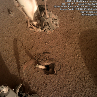
They have pulled the scoop away from the mole, exposing the pit and the depression left by the scoop. They have imaged this from several positions maybe to get a 3D model of the pit? Could we see some back-filling of the pit / depression before further hammering attempts are made, or maybe they will try and move the mole to a more upright pose by pushing from the other side during hammering?
|
|
|
|
|
|
|
Jan 30 2020, 12:02 AM
Post
#840
|
||||
|
Member Group: Members Posts: 866 Joined: 15-March 05 From: Santa Cruz, CA Member No.: 196 |
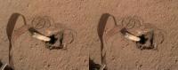
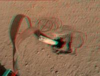
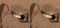
Here is one set of the sol417 stereo pairs, from the left in crosseye/anaglyph/parallel renderings:
"the alien instrument descended as dusts of ages fell away revealing a sort of portal, as if a long buried Cenote emerging from the deep to accept the sacrifice" |
|||
|
|
|
|||
|
Jan 30 2020, 07:08 PM
Post
#841
|
|
|
Member Group: Members Posts: 684 Joined: 24-July 15 Member No.: 7619 |
QUOTE (atomoid @ Jan 30 2020, 12:02 AM) Here is one set of the parallel renderings: Oh WOW. That is a HUGE amount of missing volume! Can that ALL be from compaction? I'm starting to think there is a void UNDER the duricrust, and the mole punched a small hole through which is allowing the soil to drop down into a void? |
|
|
|
|
Jan 30 2020, 08:46 PM
Post
#842
|
|
|
Senior Member Group: Members Posts: 3516 Joined: 4-November 05 From: North Wales Member No.: 542 |
QUOTE (HSchirmer @ Jan 30 2020, 08:08 PM) Can that ALL be from compaction? It was partly wondering about this that prompted me to ask the question about densities a few posts back. Apart from the visible void there is the volume now occupied by the probe itself. If the regolith here is indeed very porous and lightly packed that would initially have helped the mole to sink. Maybe the hammering causes the stuff to collapse and there is now a much denser sand 'puddle' at the bottom of the hole. |
|
|
|
|
Jan 31 2020, 11:13 AM
Post
#843
|
|
|
Senior Member Group: Members Posts: 2530 Joined: 20-April 05 Member No.: 321 |
The presence of duricrust implies the previous presence of saline water from which the water departed. To some extent, this compaction must be showing us how much water there once was.
|
|
|
|
|
Jan 31 2020, 06:53 PM
Post
#844
|
|
|
Member Group: Members Posts: 684 Joined: 24-July 15 Member No.: 7619 |
QUOTE (JRehling @ Jan 31 2020, 11:13 AM) The presence of duricrust implies the previous presence of saline water from which the water departed. To some extent, this compaction must be showing us how much water there once was. IIRC, there was a paper about a year ago that about areas that were likely re-worked by Northern-ocean Tsunami deposits, the Insight landing ellipse was inside the area that could be reworked. That would make the site roughly analogous to the US channeled scab lands or other areas subjected to recurrent catastrophic glacial lake flooding. |
|
|
|
|
Feb 2 2020, 10:51 AM
Post
#845
|
|
|
Senior Member Group: Members Posts: 1043 Joined: 17-February 09 Member No.: 4605 |
QUOTE (JRehling @ Jan 31 2020, 11:13 AM) The presence of duricrust implies the previous presence of saline water from which the water departed. To some extent, this compaction must be showing us how much water there once was. The scenario seems to be that the mole encountered a duricrust layer beneath the reasonably loose regolith. When the mole encountered the cemented layer there was insufficient friction against the barrel from the surface deposits to let it penetrate and the mole effectively bounced around compacting the (comparatively) loose material. The friction applied by the scoop permitted the mole to begin to penetrate the duricrust but the effect diminished with depth and the mole bounced back, possibly with loose material sifting down to progressively refill the hole. There is no way to tell how deep the duricrust layer is but it could be measured in metres, representing the surface a long time ago. |
|
|
|
|

|
Lo-Fi Version | Time is now: 26th April 2024 - 08:34 PM |
|
RULES AND GUIDELINES Please read the Forum Rules and Guidelines before posting. IMAGE COPYRIGHT |
OPINIONS AND MODERATION Opinions expressed on UnmannedSpaceflight.com are those of the individual posters and do not necessarily reflect the opinions of UnmannedSpaceflight.com or The Planetary Society. The all-volunteer UnmannedSpaceflight.com moderation team is wholly independent of The Planetary Society. The Planetary Society has no influence over decisions made by the UnmannedSpaceflight.com moderators. |
SUPPORT THE FORUM Unmannedspaceflight.com is funded by the Planetary Society. Please consider supporting our work and many other projects by donating to the Society or becoming a member. |
|