Updated Titan Map |

  |
Updated Titan Map |
 Jul 1 2018, 07:32 PM Jul 1 2018, 07:32 PM
Post
#226
|
|
|
Member  Group: Members Posts: 808 Joined: 10-October 06 From: Maynard Mass USA Member No.: 1241 |
Ian,
Wow, those maps are fantastic! Thank you for showing us your long hard work. The explanation of how you did it, is inspiring. You are one cool cat! -------------------- CLA CLL
|
 |
 
|
|
Jul 3 2018, 01:46 AM
Post
#227
|
|
|
Solar System Cartographer Group: Members Posts: 10150 Joined: 5-April 05 From: Canada Member No.: 227 |
Agreed! These are beautiful.
Phil -------------------- ... because the Solar System ain't gonna map itself.
Also to be found posting similar content on https://mastodon.social/@PhilStooke NOTE: everything created by me which I post on UMSF is considered to be in the public domain (NOT CC, public domain) |
|
|
|
|
Jul 6 2018, 08:48 PM
Post
#228
|
|
 Member Group: Members Posts: 120 Joined: 26-May 15 From: Rome - Italy Member No.: 7482 |
wow!

|
|
|
|
|
Jul 7 2018, 08:30 AM
Post
#229
|
|
 Junior Member Group: Members Posts: 43 Joined: 14-December 12 Member No.: 6784 |
Ian, these are simply wonderful. Thank you!
|
|
|
|
|
Jul 7 2018, 10:48 PM
Post
#230
|
|
 Lord Of The Uranian Rings Group: Members Posts: 798 Joined: 18-July 05 From: Plymouth, UK Member No.: 437 |
Thanks everyone for the positive responses.
 As I'm sure you can imagine, this data was an absolute bear to work with, so although room for improvement undoubtedly exists, I'm generally delighted with the results. As I'm sure you can imagine, this data was an absolute bear to work with, so although room for improvement undoubtedly exists, I'm generally delighted with the results.I intend to post versions incorporating the SAR radar data (perhaps colour-coded? I'm undecided on the exact presentation.) But for now, here are those three image products again, this time merged with topographical information from a paper by P. Corlies et al: 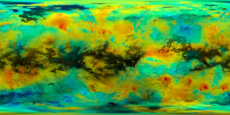 Cassini ISS Titan Mosaic & Topography: Equatorial View (USGS/Ian Regan/P.Corlies et al.) 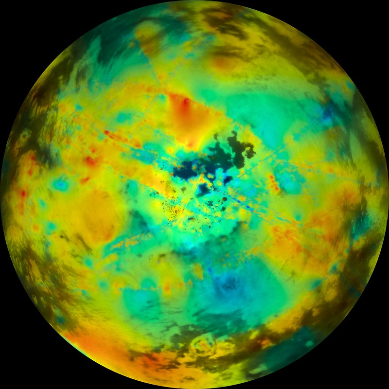 Cassini ISS Titan Mosaic & Topography: Northern Hemisphere (USGS/Ian Regan/P.Corlies et al.) 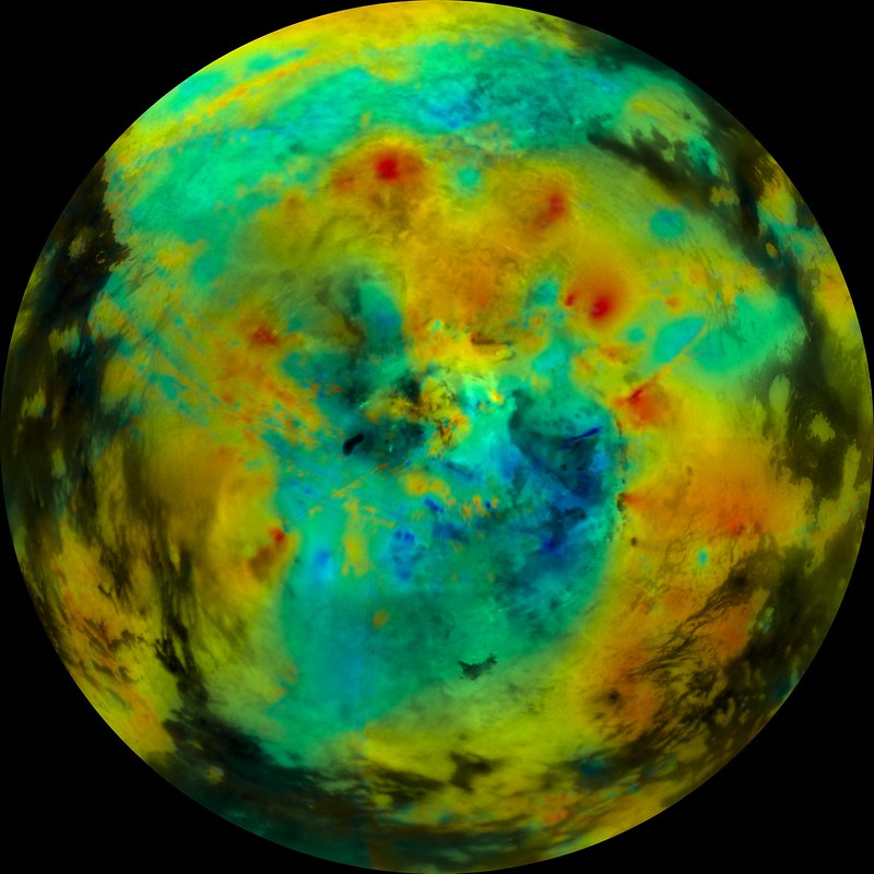 Cassini ISS Titan Mosaic & Topography: Southern Hemisphere (USGS/Ian Regan/P.Corlies et al.) Blue areas represent low-lying regions up to -1,800 metres below the average. Red areas indicates peaks of up to 650 metres. -------------------- |
|
|
|
|
Jul 8 2018, 12:54 AM
Post
#231
|
|
|
Merciless Robot Group: Admin Posts: 8783 Joined: 8-December 05 From: Los Angeles Member No.: 602 |
Let me add my voice to the chorus of
 ...incredible work, Ian. ...incredible work, Ian.Interesting that there's a high region (...for Titan; pretty flat place, really) adjacent to the north polar sea complex. Gotta wonder if that provides orographic lift & enhances precipitation to feed them. -------------------- A few will take this knowledge and use this power of a dream realized as a force for change, an impetus for further discovery to make less ancient dreams real.
|
|
|
|
|
Jul 9 2018, 06:56 PM
Post
#232
|
|
 Director of Galilean Photography Group: Members Posts: 896 Joined: 15-July 04 From: Austin, TX Member No.: 93 |
Thanks for the amazing maps Ian. Titan, being the Hydrocarbon Moon, is rather beautifully rendered like a colorful oil sheen!
-------------------- Space Enthusiast Richard Hendricks
-- "The engineers, as usual, made a tremendous fuss. Again as usual, they did the job in half the time they had dismissed as being absolutely impossible." --Rescue Party, Arthur C Clarke Mother Nature is the final inspector of all quality. |
|
|
|
|
Jul 11 2018, 12:20 AM
Post
#233
|
|
 IMG to PNG GOD Group: Moderator Posts: 2250 Joined: 19-February 04 From: Near fire and ice Member No.: 38 |
Awesome maps and clearly a lot of work that was required to complete them. Titan isn't exactly the easiest 'image processing target' to work on.
|
|
|
|
|
Jul 12 2018, 11:39 AM
Post
#234
|
|||||
|
Member Group: Members Posts: 120 Joined: 26-May 15 From: Rome - Italy Member No.: 7482 |
Ian R Magnifico! You did what I always wanted. I was hoping for these maps !!
This is the most fascinating world after the Earth. No doubt. The missions to observe Ligeia mare or Kraken sea closely are my dream, for my most important opinion of some primary mis-seals on Mars. This is my Ligeia mare model 12x17 cm. Handmade. No 3D printer. I know, it's not perfect. http://antidotumtarantulae.altervista.org/...are_Ligeia.html What color would you think of ethane-methane seas? I maybe I had to do this sea in black?
Attached thumbnail(s)
|
||||
|
|
|
||||
|
Jul 15 2018, 07:54 AM
Post
#235
|
|
|
Lord Of The Uranian Rings Group: Members Posts: 798 Joined: 18-July 05 From: Plymouth, UK Member No.: 437 |
Perhaps a deep, black-ish-brown would be the right colour? Even so, it still looks great Daniele!
-------------------- |
|
|
|
|
Jul 15 2018, 07:56 AM
Post
#236
|
|
|
Lord Of The Uranian Rings Group: Members Posts: 798 Joined: 18-July 05 From: Plymouth, UK Member No.: 437 |
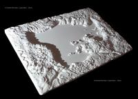
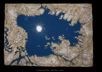
Another exercise in seam removal, but this time applied to stacked radar data from multiple Cassini flybys:
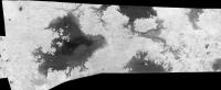
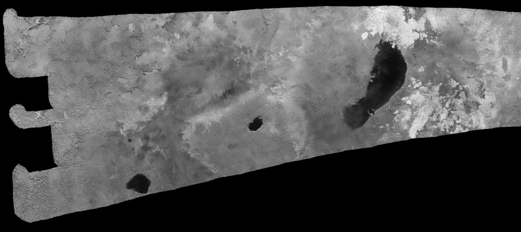 Ontario Lacus and Environs (T-39, T-57, T-58, T-65, T98) -------------------- |
|
|
|
|
Jul 15 2018, 08:38 AM
Post
#237
|
||
|
Lord Of The Uranian Rings Group: Members Posts: 798 Joined: 18-July 05 From: Plymouth, UK Member No.: 437 |
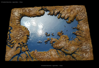
And this one might be of interest to Daniele
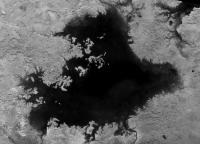
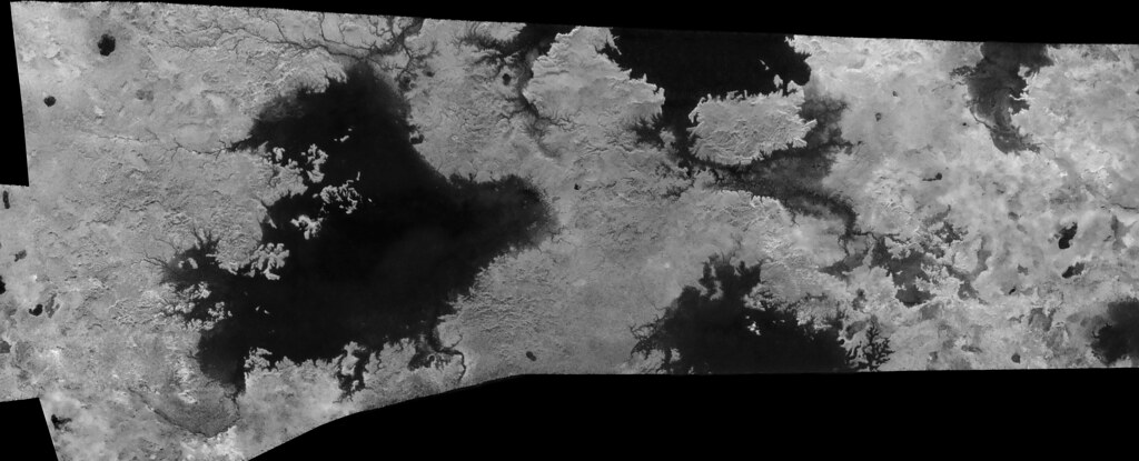 Titan: Ligeia Mare and environs (T-28, T-29, T-25, T-104)
-------------------- |
|
|
|
|
|
|
Jul 15 2018, 02:49 PM
Post
#238
|
|
|
Junior Member Group: Members Posts: 43 Joined: 14-December 12 Member No.: 6784 |
My goodness Ian those are phenomenal. Do you have plans to make more? I feel like I've never seen the lakes this clearly.
|
|
|
|
|
Jul 15 2018, 05:13 PM
Post
#239
|
|
 Senior Member Group: Moderator Posts: 3232 Joined: 11-February 04 From: Tucson, AZ Member No.: 23 |
That map of Ligeia is amazing. I like how visible the river that flows into NE Ligeia is (can see that in ISS data)
-------------------- &@^^!% Jim! I'm a geologist, not a physicist!
The Gish Bar Times - A Blog all about Jupiter's Moon Io |
|
|
|
|
Jul 15 2018, 05:54 PM
Post
#240
|
||
 Senior Member Group: Members Posts: 2530 Joined: 20-April 05 Member No.: 321 |
Ian, so much good work in every one of these products.
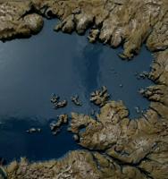
If I may, here is a brightened version of the Ligeia image, to emphasize details within the lake. It's clear that the channels continue well past the current shoreline, which would seem to indicate a lower surface level in the past.
Attached thumbnail(s)
|
|
|
|
|
|
|

|
Lo-Fi Version | Time is now: 24th April 2024 - 11:03 AM |
|
RULES AND GUIDELINES Please read the Forum Rules and Guidelines before posting. IMAGE COPYRIGHT |
OPINIONS AND MODERATION Opinions expressed on UnmannedSpaceflight.com are those of the individual posters and do not necessarily reflect the opinions of UnmannedSpaceflight.com or The Planetary Society. The all-volunteer UnmannedSpaceflight.com moderation team is wholly independent of The Planetary Society. The Planetary Society has no influence over decisions made by the UnmannedSpaceflight.com moderators. |
SUPPORT THE FORUM Unmannedspaceflight.com is funded by the Planetary Society. Please consider supporting our work and many other projects by donating to the Society or becoming a member. |
|