Dawn's first orbit, including RC3, March 6, 2015- June 15, 2015 |

  |
Dawn's first orbit, including RC3, March 6, 2015- June 15, 2015 |
 Jun 5 2015, 06:07 PM Jun 5 2015, 06:07 PM
Post
#391
|
|
|
Newbie  Group: Members Posts: 8 Joined: 20-April 15 Member No.: 7446 |
Excellent stuff, Daniele!
If you've still got your experiment tray ready to go, could you try making a crater with an extremely shallow angle impact? I'd try it myself, but I think I'd get some stern looks of disapproval for wasting food and making a mess. 
|
 |
 
|
|
Jun 5 2015, 08:42 PM
Post
#392
|
|
|
Senior Member Group: Members Posts: 3516 Joined: 4-November 05 From: North Wales Member No.: 542 |
I love to see an experiment, and the cartoon scenarios are also a great basis for discussion. Scenarios b and c look good to me for the various white spots. I would just add that in scenario b the original big impact would likely have exposed fresh ice, subsequently re-covered with dirt before the recent smaller impact event. (You don't need to rely on the coincidence that the large impact narrowly missed going deep enough, allowing the smaller one to finish the job.)
|
|
|
|
|
Jun 5 2015, 10:52 PM
Post
#393
|
||
 Member Group: Members Posts: 714 Joined: 3-January 08 Member No.: 3995 |
Same thing, different day (i.e. TIF flipped, JPG'd):
It would be interesting to know why the images end up reversed. |
|
|
|
|
|
|
Jun 5 2015, 11:07 PM
Post
#394
|
|
 Senior Member Group: Members Posts: 1629 Joined: 5-March 05 From: Boulder, CO Member No.: 184 |
-------------------- Steve [ my home page and planetary maps page ]
|
|
|
|
|
Jun 6 2015, 01:44 AM
Post
#395
|
|
|
Senior Member Group: Members Posts: 2998 Joined: 30-October 04 Member No.: 105 |
QUOTE (Gladstoner @ Jun 5 2015, 05:52 PM)  It would be interesting to know why the images end up reversed. _Very_ good question. I was starting to notice that things didn't look "quite right" and then I saw that you were noting "flipped" on your images. If I'm catching this correctly it looks like the images started to be reversed with the Southern Hemisphere campaign, PIA19554. Not a big deal, but an annoyance with annotated images. --Bill -------------------- |
|
|
|
|
Jun 6 2015, 03:42 AM
Post
#396
|
|
|
Member Group: Members Posts: 714 Joined: 3-January 08 Member No.: 3995 |
QUOTE (Bill Harris @ Jun 5 2015, 08:44 PM) If I'm catching this correctly it looks like the images started to be reversed with the Southern Hemisphere campaign, PIA19554. At least toilets on Ceres will now flush in the same direction as in the north. 
|
|
|
|
|
Jun 6 2015, 06:37 AM
Post
#397
|
|
|
Member Group: Members Posts: 315 Joined: 1-October 06 Member No.: 1206 |
QUOTE That is incredibly cool Daniele, reminiscent of some of Emily's montages. Can I make 2 small suggestions however? 1) The Chariklo image is the only non-photograph, its an artist's conception. Perhaps identify it as such 2) An image of Proteus, to scale, will remind viewers that the transition from 'round' to 'potato' shaped is not a totally predictable one P |
|
|
|
|
Jun 6 2015, 09:11 AM
Post
#398
|
|
 Member Group: Members Posts: 813 Joined: 8-February 04 From: Arabia Terra Member No.: 12 |
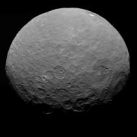
I'm really enjoying Ceres now. A great intermediary between the silicate worlds and the ice moons & TNOs. Onwards, closer!
|
|
|
|
|
Jun 6 2015, 09:20 AM
Post
#399
|
|
|
Senior Member Group: Members Posts: 3516 Joined: 4-November 05 From: North Wales Member No.: 542 |
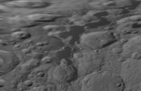
Looking back at this image I now think the big mountain may be the remains of the central peak of an almost-erased impact basin similar in size to the one at the lower left terminator here:
http://www.unmannedspaceflight.com/index.p...st&id=35981 That crater also has a central peak that takes the form of a short linear ridge with at least one white patch on its northern slope: http://www.unmannedspaceflight.com/index.p...st&id=35989 |
|
|
|
|
Jun 6 2015, 05:26 PM
Post
#400
|
|||
|
Member Group: Members Posts: 714 Joined: 3-January 08 Member No.: 3995 |
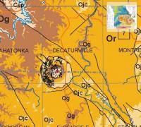
QUOTE (ngunn @ Jun 6 2015, 04:20 AM) Looking back at this image I now think the big mountain may be the remains of the central peak of an almost-erased impact basin similar in size to the one at the lower left terminator here: http://www.unmannedspaceflight.com/index.p...st&id=35981 That crater also has a central peak that takes the form of a short linear ridge with at least one white patch on its northern slope: http://www.unmannedspaceflight.com/index.p...st&id=35989 If those are central peaks, then that may indicate the white material was drawn up from below in places. The Decaturville impact structure in Missouri comes to mind:
Here, lower, older rocks were drawn up by the central rebound. The tan in the middle is Cambrian, and the red dot represents huge, rootless blocks of Precambrian granite. The outer ring is younger Ordovician. A cross section of the structure:
(Edit: ring faults not included in diagram for simplicity.) If this happened on Ceres, the sparse nature of the white stuff could indicate an overall spotty distribution, an occurrence at varying depths, or both. |
||
|
|
|
||
|
Jun 6 2015, 08:29 PM
Post
#401
|
||
|
Senior Member Group: Members Posts: 1629 Joined: 5-March 05 From: Boulder, CO Member No.: 184 |
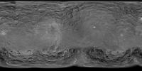
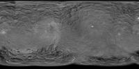
Greetings - this map version has some revisions in the area of the two southern basins to try and show more details.
Full 4K resolution and polar views are here. -------------------- Steve [ my home page and planetary maps page ]
|
|
|
|
|
|
|
Jun 6 2015, 09:02 PM
Post
#402
|
|
|
Senior Member Group: Members Posts: 3516 Joined: 4-November 05 From: North Wales Member No.: 542 |
QUOTE (Gladstoner @ Jun 6 2015, 06:26 PM) If those are central peaks, then that may indicate the white material was drawn up from below in places. Interesting idea. I was thinking of the ice being quite near the surface everywhere, as at the Mars Phoenix site, and being exposed either by fresh impacts or landsldes on steep slopes, but maybe it's mainly deeper and particular circumstances are required to bring it to the surface. There is an issue that the dirt overlying the ice may well be denser than the ice. An impact or anything else that disturbs the status quo could trigger some overturning. scalbers: great map! |
|
|
|
|
Jun 8 2015, 08:42 AM
Post
#403
|
||
|
Member Group: Members Posts: 714 Joined: 3-January 08 Member No.: 3995 |
It is tricky to discern the orientation of the valleys between the large basin and spot 5, so I took scalber's cylindrical map and brought it into Celestia:
Some valleys radiate from the basin, but the ones that extend to spot 5 do not. I thought all the valleys were due to the big basin, but something else seem to be in play. |
|
|
|
|
|
|
Jun 8 2015, 09:25 AM
Post
#404
|
|
|
Member Group: Members Posts: 910 Joined: 4-September 06 From: Boston Member No.: 1102 |
QUOTE (scalbers @ Jun 5 2015, 07:07 PM) North West and also ENE of white spots 5 are dark lake-shaped regions of uniform darkness (but not black). Are these just image artifacts or something real? -------------------- |
|
|
|
|
Jun 8 2015, 04:49 PM
Post
#405
|
||
|
Senior Member Group: Members Posts: 1629 Joined: 5-March 05 From: Boulder, CO Member No.: 184 |
I'm glad to see such helpful good eyes on this forum. The dark area to the NW (shown below) I think you're referring to would be heavily shadowed craters. I'll check to see how easy it is to substitute another image in that area. Where would be the area to the ENE of spot 5? I also still have to catch up with a map that identifies the white spots.
Attached thumbnail(s)
-------------------- Steve [ my home page and planetary maps page ]
|
|
|
|
|
|
|

|
Lo-Fi Version | Time is now: 28th April 2024 - 02:39 AM |
|
RULES AND GUIDELINES Please read the Forum Rules and Guidelines before posting. IMAGE COPYRIGHT |
OPINIONS AND MODERATION Opinions expressed on UnmannedSpaceflight.com are those of the individual posters and do not necessarily reflect the opinions of UnmannedSpaceflight.com or The Planetary Society. The all-volunteer UnmannedSpaceflight.com moderation team is wholly independent of The Planetary Society. The Planetary Society has no influence over decisions made by the UnmannedSpaceflight.com moderators. |
SUPPORT THE FORUM Unmannedspaceflight.com is funded by the Planetary Society. Please consider supporting our work and many other projects by donating to the Society or becoming a member. |
|