The major science stories from Spirit |

  |
The major science stories from Spirit |
 Nov 24 2008, 09:23 PM Nov 24 2008, 09:23 PM
Post
#1
|
|
 Administrator  Group: Admin Posts: 5172 Joined: 4-August 05 From: Pasadena, CA, USA, Earth Member No.: 454 |
I really, really, really tried to do my own research this time without relying on all you rover-watchers here for help, but after a couple of weeks of banging my head against a wall I'm coming crawling to you for help. I need to produce (for both our website and a podcast) a simplified, big-picture view of what Spirit has accomplished on Mars over the past five years. I've basically got to summarize five years of the mission in four minutes of speaking. The operational details (the main mileposts on the drive) are very easy to figure out with the help of Tesheiner's maps and the discussions in the route map thread, so I've got that in hand. What I am having trouble with is figuring out the answers to the following science questions:
1. What is the summary story that can be told about the history of the interior of Gusev crater based on Spirit's observations? Geology is fundamentally a science devoted to telling a story about a landscape -- what's the basic story that the Gusev landscape is telling us, as revealed by Spirit? 2. What are the biggest science discoveries -- I'm talking about the top three or five stories -- that Spirit has made? There's just so much material on Spirit that I'm having an awful time trying to see the forest for all the trees. All the journal articles that I can find are just devoted to one phase of the mission, so I can't figure out which stories are the most significant. I have all of Salley's great articles to go through, but again, they're so detail-rich that it's difficult to figure out what the big picture is; it's like looking at a Seurat painting up close. Any help or pointers to any place where anybody has already produced some quality science summary would be greatly appreciated. --Emily -------------------- My website - My Patreon - @elakdawalla on Twitter - Please support unmannedspaceflight.com by donating here.
|
 |
 
|
|
Nov 25 2008, 02:33 AM
Post
#2
|
|
 Senior Member Group: Members Posts: 1229 Joined: 24-December 05 From: The blue one in between the yellow and red ones. Member No.: 618 |
Emily,
Two recent papers in JGR-Planets are helpful re the Spirit/Gusev status: Arvidson et al. Spirit Mars Rover Mission to the Columbia Hills, Gusev Crater: Mission overview and selected results from the Cumberland Ridge to Home Plate. JOURNAL OF GEOPHYSICAL RESEARCH, VOL. 113, E12S33, doi:10.1029/2008JE003183, 2008 Lewis et al. Structure and stratigraphy of Home Plate from the Spirit Mars Exploration Rover. JOURNAL OF GEOPHYSICAL RESEARCH, VOL. 113, E12S36, doi:10.1029/2007JE003025, 2008 To quote from the first: QUOTE Evidence for extensive volcanic activity and aqueous alteration in the Inner Basin is also detailed, including discovery and characterization of accretionary lapilli and formation of sulfate, silica, and hematite-rich deposits. ...The evidence for aqueous alteration derived from Spirits data is associated with outcrops that are too small to be detected from orbital observations or withmaterials exposed from the shallow subsurface during rover activities. Although orbital observations show many other locations on Mars with evidence for minerals formed or altered in an aqueous environment, Spirits data imply that the older crust of Mars has been altered even more extensively than evident from orbital data. This result greatly increases the potential that the surface or shallow subsurface was once a habitable regime. And from the second: QUOTE Our results are consistent with an explosive volcaniclastic origin for the layered sediments. Analysis of bedding orientations over half of the circumference of Home Plate reveals a radially inward dipping structure, consistent with deposition in the volcanic vent, or topographic draping of a preexisting depression. Detailed observations of the sedimentology show that grain sorting varies significantly between outcrops on the east and west sides. Observations on the western side show a well-sorted population of sand sized grains which comprise the bedrock, while the eastern margin shows a wider range of grain sizes, including some coarse granules. These observations are consistent with primary deposition by a pyroclastic surge. However, aeolian reworking of the upper stratigraphic unit is not ruled out. Hope this helps -------------------- My Grandpa goes to Mars every day and all I get are these lousy T-shirts!
|
|
|
|
|
Nov 25 2008, 02:42 AM
Post
#3
|
|
|
Administrator Group: Admin Posts: 5172 Joined: 4-August 05 From: Pasadena, CA, USA, Earth Member No.: 454 |
That Arvidson et al. paper may not cover the whole mission but 1,000 sols is the biggest chunk I've seen covered in one paper -- most helpful, thanks, I hadn't seen it yet!
--Emily -------------------- My website - My Patreon - @elakdawalla on Twitter - Please support unmannedspaceflight.com by donating here.
|
|
|
|
|
Nov 25 2008, 05:22 AM
Post
#4
|
|
 Senior Member Group: Admin Posts: 3108 Joined: 21-December 05 From: Canberra, Australia Member No.: 615 |
Emily, There are a lot of 'science' achievements from Spirit's mission, and to summarise these in just a few minutes will be a challenge.
I'm sure that people here will give you many thoughts and tips. I have one thought about something you should include as an achievement aside from the science -  "The success of operating a robot explorer on an alien world, in a harsh environment, climbing 'mountains', traversing a tough rocky terrain with (just to add to the fun) sandtraps, driving on five wheels for most of the mission (backwards!), with thickening dust on its solar panels and having to keep them oriented to the Sun, surviving freezing temperatures, major and minor dust storms, partially blinded eyes, ageing instruments, travelling many, many times further than designed to do, and communicating with biological entities on a distant planet who want you to do all this great science in what was to be a 90 Sol mission which is now going on five years." The science is fantastic, the adventure is incredible! However, as to the science, here are some references that might help you: Four Years on Mars - http://www.jpl.nasa.gov/videos/mer/flightdirector-20080117/ Some nice images and comments from John Callas. The Rover's science objectives: http://marsrover.nasa.gov/science/objectives.html Significant Discovery of Wetter Mars: http://www.nasa.gov/mission_pages/mer/mer-20070521.html Contributed paper to the IAU referenced here: (not sure if you can get the full paper - you may need to subscribe) Abstract: Results of the Mars Exploration Rover mission to Mars are summarized http://journals.cambridge.org/action/displ...act?aid=1431936 Cheers Astro0 |
|
|
|
|
Nov 25 2008, 06:12 AM
Post
#5
|
|
 Member Group: Members Posts: 259 Joined: 23-January 05 From: Seattle, WA Member No.: 156 |
In a way, one of Spirit's important discoveries was a non-discovery: if Gusev was a lake bottom, as seems obvious from orbital imagery, it was subsequently filled by floods of basalt. The early bits of Spirit's mission would have been terribly frustrating if not for the relief provided by Opportunity.
|
|
|
|
|
Nov 25 2008, 07:29 AM
Post
#6
|
|
 Senior Member Group: Admin Posts: 4763 Joined: 15-March 05 From: Glendale, AZ Member No.: 197 |
If you are looking for specific events, I'd say the two huge discoveries were Pot o' Gold and Tyrone.
-------------------- If Occam had heard my theory, things would be very different now.
|
|
|
|
|
Nov 25 2008, 09:45 AM
Post
#7
|
|
|
Senior Member Group: Members Posts: 2920 Joined: 14-February 06 From: Very close to the Pyrénées Mountains (France) Member No.: 682 |
In 4 minutes, I would take Astro's advise as a statment.
Then I'll speak of the 3 major phases (and discoveries): + the Plain = basalt = deception = we must move to the Hills + the Hills = first glimpse of water action (we went there to follow the water) + inspiring breathtaking views (first Mars mountain climber  ) )+ Home Plate (the promise land) = "volcanism" (pure sand...) ...and the Exploration continue. Good luck Emily Edit: I forget to speak about DD  and cleaning events. I know, I know, no relation between them but they are 2 major "discoveries", aren't they? and cleaning events. I know, I know, no relation between them but they are 2 major "discoveries", aren't they?
-------------------- |
|
|
|
|
Nov 25 2008, 11:29 AM
Post
#8
|
|
|
Founder Group: Chairman Posts: 14432 Joined: 8-February 04 Member No.: 1 |
Best way I know to get the science story is two lectures Steve's done.
One particularly good science one is here http://www.open2.net/sciencetechnologynatu...reslecture.html - in depth on the science half. The other one, to bring it a bit more up to date, is here http://uk.youtube.com/watch?v=vOv4LnAt01E |
|
|
|
|
Nov 25 2008, 06:13 PM
Post
#9
|
|
 Senior Member Group: Moderator Posts: 3431 Joined: 11-August 04 From: USA Member No.: 98 |
This is a great topic. I'm making a new years' resolution to try to understand the science that's been done a bit more, starting with these links.
|
|
|
|
|
Nov 25 2008, 10:45 PM
Post
#10
|
|
|
Member Group: Members Posts: 384 Joined: 4-January 07 Member No.: 1555 |
Emily,
I regret that this observation is not emphasized more by NASA or SS, but to me one of Spirit's most exciting discoveries was that everything off the landing plain appears to be layered and fragmental - coarse rock fragments with generally crude layering in the Columbia Hills, and fine salty sand with fine layering in Home Plate and vicinity. Except for what may be a single included ballistic rock fragment, the Home Plate layering greatly resembles that in Meridiani, especially the pervasive low angle cross beds (with some at higher angles). Other similarities include the underlying distinctive spherule-rich bed (reportedly with crystalline hematite), and the ferric acid sulfates, locally even richer at Gusev (up to 40%) than at Meridiani (up to 30%). Despite these obvious similarities, two completely different (but fundamentally Earth-like) causes have been inferred for the two sets of layered rocks, sulfate minerals, and spherules- volcanic (pyroclastic) surge from a vanished or hidden volcano (with vanished fumaroles and accretionary lapilli) for one, and an exceedingly complex set of events involving salt evaporation from vanished or hidden muddy acid playa lakes, silicate/salt transport and deposition by the wind, and alteration and redeposition by standing and flowing acid liquid water for the other. A fragmental silica-rich bed, stratigraphically between the spherule-rich bed and the beds of Home Plate proper, so far appears to be unique to Gusev, and therefore probably ranks as Spirit's single most interesting discovery. -- HDP Don |
|
|
|
|
Nov 26 2008, 12:20 AM
Post
#11
|
|
|
Member Group: Members Posts: 279 Joined: 19-August 07 Member No.: 3299 |
The close pictures on dust devil are the plus and unique of mission of Spirit. During the summer time, when Spirit was at the top of Hill Columbia, took an original activity: Astronomy taking some sky pictures when she had plenty of energy reserve to disipel. The other important Spirit's discovery was when she was heading toward Home Plate, trying to overcome a slope, her wheels have scratched the surface and found lots of sulfate....Indication of wathering of surface.
Finally, Spirit took lots of time on the highest point of Columbia hill taking the most complete picture around the Gusev!!! And much more from others who can recall her stories... |
|
|
|
|
Nov 28 2008, 05:24 PM
Post
#12
|
|
|
Administrator Group: Admin Posts: 5172 Joined: 4-August 05 From: Pasadena, CA, USA, Earth Member No.: 454 |
Thanks for all these replies, guys. My Internet access has been limited over the holiday but I'm reading everything and plan to get some writing done early next week. It's possible I may get a chance to ask SS what he thinks the biggest science stories are -- I'm glad for those Arvidson et al papers, which I printed out for some holiday reading -- they're giving me a good review! SS wrote a companion Oppy one to the 2006 paper, but there doesn't seem to be one in press yet for 2008, which would cover the subsequent 1,000 sols. I wonder if he has a draft in preparation...
--Emily -------------------- My website - My Patreon - @elakdawalla on Twitter - Please support unmannedspaceflight.com by donating here.
|
|
|
|
|
Nov 28 2008, 05:49 PM
Post
#13
|
|
 Member Group: Members Posts: 276 Joined: 11-December 07 From: Dar es Salaam, Tanzania Member No.: 3978 |
QUOTE (dburt @ Nov 26 2008, 01:45 AM)  Emily, A fragmental silica-rich bed, stratigraphically between the spherule-rich bed and the beds of Home Plate proper, so far appears to be unique to Gusev, and therefore probably ranks as Spirit's single most interesting discovery. -- HDP Don Thank you, I was wondering when someone was going to say that! 
-------------------- |
|
|
|
|
Jan 9 2009, 10:56 PM
Post
#14
|
|
 Senior Member Group: Moderator Posts: 2785 Joined: 10-November 06 From: Pasadena, CA Member No.: 1345 |
I thought this was pretty cool: http://www.space.com/scienceastronomy/090109-mars-rocks.html
I'd been wondering why the rock spacing on Mars looked like it was kinda plopped around rather than all bunched together. This article explains tries to explain why. If the wind is undercutting the sand under the rocks as deflation proceeds, it could pitch each rock slowly forward over the eons and space them apart. Neat explanation. -Mike -------------------- Some higher resolution images available at my photostream: http://www.flickr.com/photos/31678681@N07/
|
|
|
|
|
Jan 9 2009, 11:14 PM
Post
#15
|
|
 Member Group: Members Posts: 754 Joined: 9-February 07 Member No.: 1700 |
QUOTE (Juramike @ Jan 9 2009, 02:56 PM) If the wind is undercutting the sand under the rocks as deflation proceeds, it could pitch each rock slowly forward over the eons and space them apart. -Mike Perhaps Mars is expanding. |
|
|
|
|
Jan 25 2010, 09:55 PM
Post
#16
|
|
|
Member Group: Members Posts: 194 Joined: 3-January 10 Member No.: 5156 |
Hello!
Sorry for taking this old thread up, but ... I am writing for the german wikipedia, and I am also looking for the scientific findings of the rovers. I am searching for some public accessible documents, which summarize the findings as a whole. Some of the diverse questions which I have: - What is the history of gusev? Was it filled with water? - How the layering in the rocks of columbia hills or home plate was built? - At which time does the dust devils show up? Why are they building only in gusev, and not in meridiani? - Were the Columbia Hills vulcans? Or what kind of vulcanic activities were here? - How was the layering of victoria built? Is there a cross section profile? - What where the results of analysing the Cape Verde? - What are the result of the athmospheric observations? - What is the history of meridiani planum? Was the whole meridiani planum under water? Was the water flowing? And flowing to which position? Meridiani is flat. - The layering has changed inside endurance crater, if we go deeper, due to ground water. Has this also happend in Victoria crater? - Is water the only process to built the blueberries? Is there a map for the distribution of the blueberries? - How old is Victoria or Endurance? - Are there geological annotated maps about the structure and chemistry of Meridiani Planum and Gusev/Columbia Hills? So many rocks, so many analyses ... The videos of Steve Squyres are really cool! I whished I would have the PDF for this lectures ... Thanks a lot... -------------------- Need more input ...
|
|
|
|
| Guest_Oersted_* |
Jan 26 2010, 08:59 AM
Post
#17
|
|
Guests |
QUOTE (MoreInput @ Jan 25 2010, 10:55 PM) Hello! Sorry for taking this old thread up, but ... I am writing for the german wikipedia, and I am also looking for the scientific findings of the rovers. I am searching for some public accessible documents, which summarize the findings as a whole. How about the English-language Wikipedia page on that very subject? "Scientific information from the Mars Exploration Rover mission" http://en.wikipedia.org/wiki/Scientific_in...n_Rover_mission |
|
|
|
|
Jan 26 2010, 07:30 PM
Post
#18
|
|
|
Member Group: Members Posts: 194 Joined: 3-January 10 Member No.: 5156 |
Thanks a lot for this link. I already have seen it, but it is totally outdated. And also it references some "science mag" articles i can't access

-------------------- Need more input ...
|
|
|
|
|
Jan 26 2010, 07:39 PM
Post
#19
|
|
|
Founder Group: Chairman Posts: 14432 Joined: 8-February 04 Member No.: 1 |
The Spirit Wiki article isn't great - but it's actually reasonably comprehensive and up to date.
|
|
|
|
| Guest_Oersted_* |
Jan 26 2010, 09:40 PM
Post
#20
|
|
Guests |
Maybe a job for some intrepid UMSF'er?
|
|
|
|
|
Feb 3 2010, 09:42 PM
Post
#21
|
|
|
Member Group: Members Posts: 194 Joined: 3-January 10 Member No.: 5156 |
Ok, I think I have a good start point. As Emily stated in another thread, the abstract of the LPSC conferences are giving a good overview of what the scientist found out. They are really short, and mostly there is a short conclusion of what the findings do tell us.
I just downloaded 200 of them about the rovers and try to understand this stuff. Also this statement of her may help: "Googling individual authors whose LPSC abstracts indicate they do a lot of work in this field may lead you to personal websites where they post PDF copies of their published papers", I will test it -------------------- Need more input ...
|
|
|
|
|
Jun 4 2010, 06:46 PM
Post
#22
|
|
|
Member Group: Members Posts: 204 Joined: 14-April 06 From: Seattle, WA Member No.: 745 |
An article published yesterday in Science reports that the rock "Comanche" that Spirit visited in 2005 a lot of carbonate.
"This is one of the most significant findings by the rovers," said Steve Squyres. "Magnesium iron carbonate makes up about one-fourth of the measured volume in Comanche. That is a tenfold higher concentration than any previously identified for carbonate in a Martian rock." It is amazing it took them so long to get this. This mission continues to amaze. I don't have access to the Science article; the JPL Release is here. |
|
|
|
|
Jun 4 2010, 09:21 PM
Post
#23
|
|
|
Senior Member Group: Members Posts: 1229 Joined: 24-December 05 From: The blue one in between the yellow and red ones. Member No.: 618 |
Good old Comanche! I always suspected that rock was special.
It was a question about the sparkly bits visible in its MIs that motivated my first post to UMSF - wayyy back when. Now my followup question is whether those specular reflections may have come off crystals of magnesium iron carbonate! I have seen precious few such sparkles in MIs before or since Comanche. I love the irony that such sought-after stuff was signaling its presence in such an eye-catching manner YEARS before it would be formally recognized. Rock hound comments? -------------------- My Grandpa goes to Mars every day and all I get are these lousy T-shirts!
|
|
|
|
|
Jun 4 2010, 09:44 PM
Post
#24
|
|
|
Merciless Robot Group: Admin Posts: 8784 Joined: 8-December 05 From: Los Angeles Member No.: 602 |
QUOTE (Ron Hobbs @ Jun 4 2010, 10:46 AM) It is amazing it took them so long to get this. Not too surprising, though. The modus operandi from the beginning was data acquisition while the rovers are functional; detailed data reduction & analysis can obviously wait, gotta get the data while the gettin's good. Since Spirit's doing some extended downtime, the flood rate's down by half, so there's finally some time to go back & take a hard look at stuff from earlier in the mission. -------------------- A few will take this knowledge and use this power of a dream realized as a force for change, an impetus for further discovery to make less ancient dreams real.
|
|
|
|
|
Jun 4 2010, 10:09 PM
Post
#25
|
|
|
Member Group: Members Posts: 204 Joined: 14-April 06 From: Seattle, WA Member No.: 745 |
Even to my amateur eye, Comanche was one of the most intriguing outcrops either of the rovers came across. More than any other, it made me think of outcrops in the Southwest US. I remember thinking that I wished that they could have spent more time there.
I guess I shouldn't be surprised that discoveries are coming out of observations made so long ago. I do tell students in my presentations that their children, and maybe even grandchildren, will be making discoveries from data now being collected. Speaking of archival data, there is a lot in this forum. Here is a link to a long forgotten thread with pictures of this curious outcrop. Comanche picture |
|
|
|
|
Jun 6 2010, 02:52 AM
Post
#26
|
|
|
Senior Member Group: Members Posts: 2998 Joined: 30-October 04 Member No.: 105 |
QUOTE It was a question about the sparkly bits visible in its MIs that motivated my first post to UMSF - wayyy back when. I remember that. Do a Search on the term "comanche" and you'll end up with a page of hits. I'm going to browse and refresh my recollections on that area... --Bill --PS Spirit was there around Sol 697 if you need to dig. --PPS There was a dedicated Comanche thread in 2005, it is a good backgrounder on Comanche: http://www.unmannedspaceflight.com/index.php?showtopic=1854 And a larger thread on the descent into the Inner Basin: http://www.unmannedspaceflight.com/index.php?showtopic=1707 -------------------- |
|
|
|
|
Jun 14 2010, 07:00 AM
Post
#27
|
|
 Senior Member Group: Members Posts: 2228 Joined: 1-December 04 From: Marble Falls, Texas, USA Member No.: 116 |
I guess the story here may be that carbonate minerals may be more common on Mars than our remote sensing tools have previously led us to believe. The ancient geochemistry of Mars is a bit more interesting than was initially assumed. I see the story evolving to where there is an historical geochemical dichotomy based on groundwater pH.
-------------------- ...Tom
I'm not a Space Fan, I'm a Space Exploration Enthusiast. |
|
|
|
|
Jun 18 2010, 04:10 PM
Post
#28
|
|
|
Senior Member Group: Members Posts: 2998 Joined: 30-October 04 Member No.: 105 |
Indeed. The formation of carbonates is so varied that they can be indicators of many processes. In my area, B'ham, AL, look at the carbonates present in the column: Starting out with the dolomitic/cherty Cambrian Knox Group, through the Red Mountain Formation and the petroliferous biogenic Bangor Limestone, up to the Cretaceous (and later) marls and chalks.
I think that carbonates have a weak-ish spectral signature (compared to hematite and phyllosilicates) and is masked by the pervasive "limonite dust" (not totally correct, that is what I have informally called it for years) that covers everything on Mars. It will be interesting to see how this study develops. --Bill -------------------- |
|
|
|
|
Oct 28 2010, 10:40 PM
Post
#29
|
|
|
Member Group: Members Posts: 401 Joined: 5-January 07 From: Manchester England Member No.: 1563 |
Don't know how major this is, but if it's innapropriate here I'm sure the mod team will move it: Spirit finds evidence of subsurface water, JPL
-------------------- |
|
|
|
|
Oct 29 2010, 12:48 PM
Post
#30
|
|
|
Junior Member Group: Members Posts: 55 Joined: 6-March 10 From: Cincinnati, OH Member No.: 5246 |
Arvidson et al. presented a two-page abstract on this at 2010 LPSC.
http://www.lpi.usra.edu/meetings/lpsc2010/pdf/1247.pdf. Tom |
|
|
|
|
Nov 1 2010, 04:23 PM
Post
#31
|
|
|
Member Group: Members Posts: 507 Joined: 10-September 08 Member No.: 4338 |
Anyone wear a Spirit costume for Halloween?
|
|
|
|
|
Nov 1 2010, 04:36 PM
Post
#32
|
|
 Senior Member Group: Members Posts: 1431 Joined: 26-July 08 Member No.: 4270 |
 ! !
-------------------- -- Hungry4info (Sirius_Alpha)
|
|
|
|
|
Apr 23 2011, 04:15 PM
Post
#33
|
||
|
Solar System Cartographer Group: Members Posts: 10164 Joined: 5-April 05 From: Canada Member No.: 227 |
This isn't really the best thread for this post, but I'm not sure it needs a new thread now.
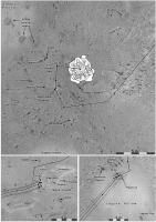
I am finishing up work on my Mars Atlas vol. 1 (up to Mars Express) and looking ahead at Vol. 2 (MER to present). All the text is done in draft form, so it's illustrations I am looking at. This is an experimental version of a map of early Spirit operations. The whole route would be mapped at larger scale (lower resolution) but sites of interest will be covered like this. Placenames are a problem. They were for Phoenix as well. Supposedly, they are accessible via the Analyst's Notebook at PDS, but that is filled with inconsistencies, with uncertainty regarding the identity of the named feature, etc. And looking ahead, I see that later in the mission most names are omitted from the Analyst's notebook. (Mission Ops people! Do us a favor, please keep and make available a proper record of the names you assign!) Phil
-------------------- ... because the Solar System ain't gonna map itself.
Also to be found posting similar content on https://mastodon.social/@PhilStooke Maps for download (free PD: https://upload.wikimedia.org/wikipedia/comm...Cartography.pdf NOTE: everything created by me which I post on UMSF is considered to be in the public domain (NOT CC, public domain) |
|
|
|
|
|
|
Apr 23 2011, 06:09 PM
Post
#34
|
|
|
Member Group: Members Posts: 194 Joined: 3-January 10 Member No.: 5156 |
QUOTE (Phil Stooke @ Apr 23 2011, 05:15 PM) I am finishing up work on my Mars Atlas vol. 1 (up to Mars Express) and looking ahead at Vol. 2 (MER to present). All the text is done in draft form, so it's illustrations I am looking at. This is an experimental version of a map of early Spirit operations. The whole route would be mapped at larger scale (lower resolution) but sites of interest will be covered like this. Wonderfull news. I really like maps, and I really like this mission. Is there any release date of this Mars atlas? QUOTE (Phil Stooke @ Apr 23 2011, 05:15 PM) Placenames are a problem. They were for Phoenix as well. Supposedly, they are accessible via the Analyst's Notebook at PDS, but that is filled with inconsistencies, with uncertainty regarding the identity of the named feature, etc. And looking ahead, I see that later in the mission most names are omitted from the Analyst's notebook. Yes, I tried to make a list of the analyzed objects for Wikipedia. A full list of analyzed object would be useless, and which object would be really relevant to know about? So I gave up this list. -------------------- Need more input ...
|
|
|
|
|
Apr 23 2011, 06:22 PM
Post
#35
|
|
|
Solar System Cartographer Group: Members Posts: 10164 Joined: 5-April 05 From: Canada Member No.: 227 |
I will submit it to the publisher at the end of this year for release late next year. Phil http://publish.uwo.ca/~pjstooke/marsatlas.htm -------------------- ... because the Solar System ain't gonna map itself.
Also to be found posting similar content on https://mastodon.social/@PhilStooke Maps for download (free PD: https://upload.wikimedia.org/wikipedia/comm...Cartography.pdf NOTE: everything created by me which I post on UMSF is considered to be in the public domain (NOT CC, public domain) |
|
|
|
|
Apr 23 2011, 10:04 PM
Post
#36
|
|
|
Administrator Group: Admin Posts: 5172 Joined: 4-August 05 From: Pasadena, CA, USA, Earth Member No.: 454 |
QUOTE (Phil Stooke @ Apr 23 2011, 09:15 AM) Placenames are a problem... I'm curious how you're going about trying to figure out place names, in the absence of good historical records, because periodically I have to try to go back and figure out what something was called (or, more commonly, do the reverse action, finding an image of a place knowing only its name). I would usually begin by looking at the Pancam database to see if there was a targeted observation of the place of interest, at the rover updates on the mission website to see if it was mentioned in there, and at Salley's stories. Where else can you locate this information? Also, on MER there's a distinction between named locations and objects, and the names for the specific spots at those locations or objects where in-situ observations were made -- I hope you're not trying to track down all the names for those? This information is surely in some JPL database somewhere. I'd guess that if you had a specific set of things that were stumping you, a rover driver might be able to dig around and answer your questions, but that list could get kind of long for a 7-year mission.... -------------------- My website - My Patreon - @elakdawalla on Twitter - Please support unmannedspaceflight.com by donating here.
|
|
|
|
|
Apr 23 2011, 10:21 PM
Post
#37
|
|
|
Solar System Cartographer Group: Members Posts: 10164 Joined: 5-April 05 From: Canada Member No.: 227 |
Here are the Analysts' notebooks:
http://an.rsl.wustl.edu/mer/ And here are the site maps: http://an.rsl.wustl.edu/mer/merbrowser/bro...=map&m=MERA Select a site, play with the map dimensions, and you get a map of named features. You're right, I don't want every name, and I am mainly looking for names of objects like a rock or hollow, not a remote-sensing or IDD target. But it's not always easy to tell which object a name refers to. Phil -------------------- ... because the Solar System ain't gonna map itself.
Also to be found posting similar content on https://mastodon.social/@PhilStooke Maps for download (free PD: https://upload.wikimedia.org/wikipedia/comm...Cartography.pdf NOTE: everything created by me which I post on UMSF is considered to be in the public domain (NOT CC, public domain) |
|
|
|
|
Apr 3 2014, 03:34 PM
Post
#38
|
|
|
Member Group: Members Posts: 311 Joined: 31-August 05 From: Florida & Texas, USA Member No.: 482 |
Evidence for a Noachian-aged ephemeral lake in Gusev crater, Mars
summary: alteration of Comanche is consistent with low-temperature evaporites from near-surface water-rock solutions and equivalent to nearby Algonquin outcrops. http://geology.gsapubs.org/content/42/4/359.abstract |
|
|
|
|
Apr 8 2014, 05:35 PM
Post
#39
|
|
|
Member Group: Members Posts: 194 Joined: 3-January 10 Member No.: 5156 |
QUOTE (Marz @ Apr 3 2014, 04:34 PM) Evidence for a Noachian-aged ephemeral lake in Gusev crater, Mars Here the paper from lpsc of 2014: http://www.hou.usra.edu/meetings/lpsc2014/pdf/1739.pdf -------------------- Need more input ...
|
|
|
|
|
Apr 21 2014, 12:33 PM
Post
#40
|
|
|
Member Group: Members Posts: 282 Joined: 18-June 04 Member No.: 84 |
Just wondering here
 , but if mission planners had Mars Reconnaissance Orbiter - HiRISE and CRISM data in particular available to them when they were selecting a landing site for Spirit, do you think they would have selected a different site to Gusev Crater? , but if mission planners had Mars Reconnaissance Orbiter - HiRISE and CRISM data in particular available to them when they were selecting a landing site for Spirit, do you think they would have selected a different site to Gusev Crater?
|
|
|
|
|
Apr 21 2014, 01:39 PM
Post
#41
|
|
|
Founder Group: Chairman Posts: 14432 Joined: 8-February 04 Member No.: 1 |
That's a virtually unplayable and pointless game of what-if. The majority of the MER landing site selection process was driven by engineering anyway.
|
|
|
|
|

|
Lo-Fi Version | Time is now: 22nd May 2024 - 12:50 PM |
|
RULES AND GUIDELINES Please read the Forum Rules and Guidelines before posting. IMAGE COPYRIGHT |
OPINIONS AND MODERATION Opinions expressed on UnmannedSpaceflight.com are those of the individual posters and do not necessarily reflect the opinions of UnmannedSpaceflight.com or The Planetary Society. The all-volunteer UnmannedSpaceflight.com moderation team is wholly independent of The Planetary Society. The Planetary Society has no influence over decisions made by the UnmannedSpaceflight.com moderators. |
SUPPORT THE FORUM Unmannedspaceflight.com is funded by the Planetary Society. Please consider supporting our work and many other projects by donating to the Society or becoming a member. |
|