Sol581: Spirit Arrived!, ...on the summit of Husband hill |

  |
Sol581: Spirit Arrived!, ...on the summit of Husband hill |
 Aug 22 2005, 11:53 AM Aug 22 2005, 11:53 AM
Post
#31
|
|
 Member  Group: Members Posts: 562 Joined: 29-March 05 Member No.: 221 |
yeeesssssss
|
 |
 
|
|
Aug 22 2005, 11:57 AM
Post
#32
|
|
|
Senior Member Group: Members Posts: 2820 Joined: 22-April 05 From: Ridderkerk, Netherlands Member No.: 353 |
Edstrick,
I think you can not reach the end of that overlook ( Bryce Point ). When you look at the 3D panorama from MichaelT, you can see that there are at least 2 gullys in it. I can not see how deep they are. jvandriel |
|
|
|
|
Aug 22 2005, 11:59 AM
Post
#33
|
|
 Chief Assistant Group: Admin Posts: 1409 Joined: 5-January 05 From: Ierapetra, Greece Member No.: 136 |
 I was waiting for yours Tman! Awesome.. if you care to do the other eye like this you have a one-million-dollar anaglyph! I was waiting for yours Tman! Awesome.. if you care to do the other eye like this you have a one-million-dollar anaglyph!  Please? Please?Nico -------------------- photographer, space imagery enthusiast, proud father and partner, and geek.
http://500px.com/sacred-photons & |
|
|
|
|
Aug 22 2005, 12:02 PM
Post
#34
|
|
|
Senior Member Group: Members Posts: 1870 Joined: 20-February 05 Member No.: 174 |
I'm unable to do 3-D stereo pairs at all.... Left eye is 20/200 due to amblyopia... I think there may be a route........ we can see better when we wander off to the east after finishing this outlook.
And, Oh... think of the 3-D view of the hills to the north with a stereo-baseline between the two summits! |
|
|
|
|
Aug 22 2005, 12:05 PM
Post
#35
|
|
|
Founder Group: Chairman Posts: 14432 Joined: 8-February 04 Member No.: 1 |
Nicely done on the matching there Tman - a beauty
Doug |
|
|
|
|
Aug 22 2005, 12:20 PM
Post
#36
|
||
|
Member Group: Members Posts: 236 Joined: 21-June 05 Member No.: 417 |
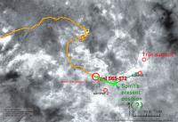
QUOTE (edstrick @ Aug 22 2005, 12:22 PM) Stealing JVandriel's panorama's central half... Here's a proposed route <not including a possible jog to the south shoulder of the hill for a first overlook into the South Hollow> of a traverse to the second summit for an overlook into the Northeast Hollow. The geology there is distinctive and interesting in MOC image data and would well be worth a trip to check out if the South Hollow and Home Plate weren't even better. So we'd better get a good look that direction.. may be very useful, even possibly essential in understanding the geologic structure and origin of the hills.  I'm a bit lost here... Since Spirit is looking towards the east in that picture (Thira crater at the horizon), 'summit 2' should be behind Spirit. I'm convinced she's sitting on the crest somewhere between 'summit 1' and 'summit 2', and that it is 'summit 1' we're seeing. 
Attached thumbnail(s)
|
|
|
|
|
|
|
Aug 22 2005, 12:30 PM
Post
#37
|
|
 Interplanetary Dumpster Diver Group: Admin Posts: 4404 Joined: 17-February 04 From: Powell, TN Member No.: 33 |
This might be the pan ever!
-------------------- |
|
|
|
|
Aug 22 2005, 01:03 PM
Post
#38
|
|
 Special Cookie Group: Members Posts: 2168 Joined: 6-April 05 From: Sintra | Portugal Member No.: 228 |
Maybe not 100% accurate but...what is the teamwork for?...
http://i16.photobucket.com/albums/b14/ustrax3/references.jpg -------------------- "Ride, boldly ride," The shade replied, "If you seek for Eldorado!"
Edgar Alan Poe |
|
|
|
|
Aug 22 2005, 01:26 PM
Post
#39
|
|
 Member Group: Members Posts: 198 Joined: 2-March 05 From: Richmond, VA USA Member No.: 181 |
Is my understanding correct in thinking that Husband Hill is thought to be the highest in these hills? It came as a little suprise to me to see McCool and Ramon hills still 'looming' taller in sol581's NavCam shots. (http://207.7.139.5/mars/spirit/navcam/2005-08-21/2N177951296EFFADNDP0645R0M1.JPG)
I agree that we still have some small vertical distance still to climb to be at least very near the maximum vertical extent of Husband Hill (http://207.7.139.5/mars/spirit/rear_hazcam/2005-08-21/2R177950900EFFADNDP1312L0M1.JPG), but not enough it seems to be able to peak over either McCool or Ramon hills. This is not a diminishment of Spirit's (nor her controlers') fantastic effort -- Onwards and Upwards! -- Pertinax |
|
|
|
|
Aug 22 2005, 01:26 PM
Post
#40
|
|
|
Member Group: Members Posts: 252 Joined: 27-April 05 Member No.: 365 |
Looking at that overhead of Thira and the Columbia Hills it seems that Spirit really plopped down in Dust Devil Alley. Other parts of Gusev seem devoid of DD tracks. Perhaps that area is the 'sweet spot' where the wind passing over and through the crater has just the right amount of turbulence to promote DD development. Had Spirit landed elsewhere in Gusev, she might still be searching for shows of DD's.
|
|
|
|
|
Aug 22 2005, 02:38 PM
Post
#41
|
|
|
Member Group: Members Posts: 562 Joined: 29-March 05 Member No.: 221 |
QUOTE (edstrick @ Aug 22 2005, 01:02 PM) I'm unable to do 3-D stereo pairs at all.... Left eye is 20/200 due to amblyopia... edstrick - there is a 3D technique i have seen which is very rarely employed which i would guess is called something like 'waggle 3D'. essentially you make an animated gif that flicks between the two images, left cam right cam, and at a certain frequency your brain perceived the depth. It should give the perception of depth even when looking with only one eye because the perception of depth comes not from have two different static images the require you to look with both eyes simultaneously but from your brain interpreting the relative differences in the offset as motion/depth. i.e., the images look like little 3D models being rotated. In fact i've seen waggle 3D images on somebodies mars blog.... |
|
|
|
|
Aug 22 2005, 03:08 PM
Post
#42
|
|
 Member Group: Members Posts: 593 Joined: 20-April 05 Member No.: 279 |
QUOTE (Pertinax @ Aug 22 2005, 01:26 PM) Is my understanding correct in thinking that Husband Hill is thought to be the highest in these hills? It came as a little suprise to me to see McCool and Ramon hills still 'looming' taller in sol581's NavCam shots. Hi Pertinax...I've seen the same effect on Earth. I was up Scafell Pike years ago - this is England's highest hill at 977 metres. A kilometre away, the nearby summit of Sca Fell (964 m) clearly looked higher than I was because it jutted above the horizon. Remember that on a summit, the horizon of a curved planet is below the true horizontal. It's 1 degree from Scafell Pike, 0.44 degrees from a 100m tall Husband Hill on Mars. I put it down to our brains playing tricks, since our (generally) ground-based experience is that anything which appears above a horizon must be higher than our own vantage point. Andy G |
|
|
|
|
Aug 22 2005, 03:11 PM
Post
#43
|
|
 Martian Photographer Group: Members Posts: 352 Joined: 3-March 05 Member No.: 183 |
QUOTE (Pertinax @ Aug 22 2005, 01:26 PM) Is my understanding correct in thinking that Husband Hill is thought to be the highest in these hills? It came as a little suprise to me to see McCool and Ramon hills still 'looming' taller in sol581's NavCam shots. The problem is that Mars isn't flat--curvature is more of a factor than for Earth. Curvature pushes down the distant horizon. So, a nearby hill that is almost as tall as your vantage point appears just a little greater than 90 deg below zenith. A 70 km distant hill, even if much taller, can appear more than 90 deg below the horizon. I haven't done the math in this case, but I've seen the affect on Earth, and it'll be bigger on mars. |
|
|
|
|
Aug 22 2005, 03:13 PM
Post
#44
|
|
|
Senior Member Group: Members Posts: 2998 Joined: 30-October 04 Member No.: 105 |
QUOTE (MichaelT @ Aug 22 2005, 05:27 AM) The quite sudden transition from the steep slope to the plateau would lead to the formation of a vortex right behind that edge, causing dust deposition right there. If you had a more rounded mountain top, the airflow would be more laminar and such ripples would not be present. On Earth you often find similar structures on snow-covered mountains. Michael The dunes surprised me. On the climb to the top, we've been seeing increasingly wind-scoured terrain and I wasn't expecting to see deep and widespread dunes. I have a concern about hazardous footing due to loose sand, here on the top of the hill but especially on the downwind south side of the hill. I hope we won't run into problems on this next leg of our adventure. --Bill -------------------- |
|
|
|
|
Aug 22 2005, 03:19 PM
Post
#45
|
|
|
Member Group: Members Posts: 198 Joined: 2-March 05 From: Richmond, VA USA Member No.: 181 |
Doh!
 Deimos and Andy, thank you both -- you are 100% correct. I feel a little silly not having thought of that. My main personal reference point was my time working on New Hampshire's Mt. Washington, where all the surrounding summits were well below the horizon. But, there the adjecent peaks were both close (within several miles) and ~500 -~900 feet lower in elevation. Thank you again. -- Pertinax |
|
|
|
|

|
Lo-Fi Version | Time is now: 26th April 2024 - 03:20 PM |
|
RULES AND GUIDELINES Please read the Forum Rules and Guidelines before posting. IMAGE COPYRIGHT |
OPINIONS AND MODERATION Opinions expressed on UnmannedSpaceflight.com are those of the individual posters and do not necessarily reflect the opinions of UnmannedSpaceflight.com or The Planetary Society. The all-volunteer UnmannedSpaceflight.com moderation team is wholly independent of The Planetary Society. The Planetary Society has no influence over decisions made by the UnmannedSpaceflight.com moderators. |
SUPPORT THE FORUM Unmannedspaceflight.com is funded by the Planetary Society. Please consider supporting our work and many other projects by donating to the Society or becoming a member. |
|