InSight Surface Operations, 26 Nov 2018- 21 Dec 2022 |

  |
InSight Surface Operations, 26 Nov 2018- 21 Dec 2022 |
 Nov 27 2018, 02:49 PM Nov 27 2018, 02:49 PM
Post
#16
|
|
|
Member  Group: Members Posts: 157 Joined: 22-May 09 From: Ireland Member No.: 4792 |
A live view of the engineers reactions (YouTube) - a team sometimes less-mentioned: success, hugs, high-5's, fist-bumps, love, of exploration.
John |
 |
 
|
|
Nov 27 2018, 02:49 PM
Post
#17
|
|
|
Solar System Cartographer Group: Members Posts: 10226 Joined: 5-April 05 From: Canada Member No.: 227 |
The MSL cruise stage made it to ground in pieces, and the splats were seen by HiRISE.
https://www.uahirise.org/ESP_029245_1755 Phil -------------------- ... because the Solar System ain't gonna map itself.
Also to be found posting similar content on https://mastodon.social/@PhilStooke Maps for download (free PDF: https://upload.wikimedia.org/wikipedia/comm...Cartography.pdf NOTE: everything created by me which I post on UMSF is considered to be in the public domain (NOT CC, public domain) |
|
|
|
|
Nov 27 2018, 03:15 PM
Post
#18
|
|
 Member Group: Members Posts: 559 Joined: 1-May 06 From: Scotland (Ecosse, Escocia) Member No.: 759 |
Thanks Phil. So no tungsten blocks this time, but I'm guessing there will surely be a lighter splatter out there somewhere.
|
|
|
|
|
Nov 27 2018, 03:40 PM
Post
#19
|
|
 Member Group: Members Posts: 214 Joined: 30-December 05 Member No.: 628 |
In the early stages of the mission, can InSight's seismometer be used in concert with the hammer that is to drive the thermal mole into the ground, as a sort of sonar device to help locate buried rocks and maybe identify the best path to get the mole all the way to its desired 5 meter depth?
Sorry- this belongs in the surface operations thread, which is where I intended to put it. I guess I can't move it now without some assistance from admin... Moved. -Admin. |
|
|
|
|
Nov 27 2018, 04:16 PM
Post
#20
|
|
|
Solar System Cartographer Group: Members Posts: 10226 Joined: 5-April 05 From: Canada Member No.: 227 |
Right! So in this image:
https://static.uahirise.org/images/2012/det...BM-2H-scale.jpg the two largest splats are thought to be the tungsten blocks, but all the others are fragments of the cruise stage. Something similar should be visible to us this time. Every previous US lander except the Vikings had cruise stages which would have done this, but we didn't have a great camera to look for them before this (exception, Phoenix, but I never saw a search for cruise stage scars - maybe CTX from just after the Phoenix landing would reveal cruise stage impacts). Presumably the older mission cruise stage scars would be faded by now. Phil -------------------- ... because the Solar System ain't gonna map itself.
Also to be found posting similar content on https://mastodon.social/@PhilStooke Maps for download (free PDF: https://upload.wikimedia.org/wikipedia/comm...Cartography.pdf NOTE: everything created by me which I post on UMSF is considered to be in the public domain (NOT CC, public domain) |
|
|
|
|
Nov 27 2018, 04:45 PM
Post
#21
|
|
 Forum Contributor Group: Members Posts: 1374 Joined: 8-February 04 From: North East Florida, USA. Member No.: 11 |
QUOTE (tanjent @ Nov 27 2018, 04:40 PM)  In the early stages of the mission, can InSight's seismometer be used in concert with the hammer that is to drive the thermal mole into the ground, as a sort of sonar device to help locate buried rocks and maybe identify the best path to get the mole all the way to its desired 5 meter depth? Moved. -Admin. There was no mention of that. The PI did say small rocks would be pushed aside by the Mole, but if it hit a big flat rock then that was as far as they could go, it won't go upwards. It's all about risk. |
|
|
|
|
Nov 27 2018, 05:12 PM
Post
#22
|
|
|
Member Group: Members Posts: 559 Joined: 1-May 06 From: Scotland (Ecosse, Escocia) Member No.: 759 |
My initial (and highly speculative) impression from the first images from each camera is that Insight has luckily landed inside one of those circular sandy areas that we first saw at the Spirit rover landing site in 2004. I think they were perhaps shallow craters in-filled with wind-blown dust and sand. The flat sandy terrain visible by the landing leg seems to finish abruptly a few tens of meters off, at rougher boulder terrain, from the higher viewpoint looking out alongside the seismometer cover.
But we will find out more fully in due course ! |
|
|
|
|
Nov 27 2018, 05:52 PM
Post
#23
|
|
 Senior Member Group: Members Posts: 1619 Joined: 12-February 06 From: Bergerac - FR Member No.: 678 |
First of all, a big applause for the team which have landed InSight on Mars. They've done it. Again. I am grateful to live such great moments
 Second, I put my hand on the first IDC image downlinked, to remove some artifacts, review a little bit the colors. 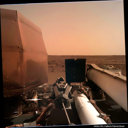 And, I got my website updated, so it can receive further processing based on IDC (and maybe ICC). -------------------- |
|
|
|
|
Nov 27 2018, 06:12 PM
Post
#24
|
|
|
Forum Contributor Group: Members Posts: 1374 Joined: 8-February 04 From: North East Florida, USA. Member No.: 11 |
QUOTE (kenny @ Nov 27 2018, 06:12 PM) ... The flat sandy terrain visible by the landing leg seems to finish abruptly a few tens of meters off, at rougher boulder terrain, from the higher viewpoint looking out alongside the seismometer cover... To my eyes it looks like sandy spots interspersed with rocky spots. A billion years of wind and no rain can do strange things... And I still don't think it was the parking lot they expected. |
|
|
|
|
Nov 27 2018, 06:43 PM
Post
#25
|
|
|
Founder Group: Chairman Posts: 14434 Joined: 8-February 04 Member No.: 1 |
QUOTE (MahFL @ Nov 27 2018, 10:12 AM) And I still don't think it was the parking lot they expected. In the IDC image there is exactly one rock that could have caused a landing issue. There's nothing else out there that looks like it could have been an impairment to landing, or instrument deployment. This is exactly what was expected. From https://sharad.psi.edu/~ibsmith/pubs/Golombek_SSR_2016.pdf "Rock abundance in the smooth terrain averages ∼2.5 % (well below the 10 % requirement)" Seems we got what we ordered. |
|
|
|
|
Nov 27 2018, 07:07 PM
Post
#26
|
||
|
Solar System Cartographer Group: Members Posts: 10226 Joined: 5-April 05 From: Canada Member No.: 227 |
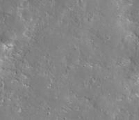
This is what HiRISE looks like in the approximate landing area (image number in file name if you save it). Lots of smooth patches between slightly rougher patches. Really not too many serious hazards. I'm looking! But we don't have much to go on yet.
Phil
-------------------- ... because the Solar System ain't gonna map itself.
Also to be found posting similar content on https://mastodon.social/@PhilStooke Maps for download (free PDF: https://upload.wikimedia.org/wikipedia/comm...Cartography.pdf NOTE: everything created by me which I post on UMSF is considered to be in the public domain (NOT CC, public domain) |
|
|
|
|
|
|
Nov 27 2018, 09:51 PM
Post
#27
|
|
 Member Group: Members Posts: 613 Joined: 23-February 07 From: Occasionally in Columbia, MD Member No.: 1764 |
QUOTE (tanjent @ Nov 27 2018, 11:40 AM) In the early stages of the mission, can InSight's seismometer be used in concert with the hammer that is to drive the thermal mole into the ground, as a sort of sonar device to help locate buried rocks and maybe identify the best path to get the mole all the way to its desired 5 meter depth? Yes, and no. Yes, the seismometers will listen as the HP3 mole hammers itself into the ground, and will deduce near-surface seismic properties therefrom. Conceivably one could deduce the presence of reflectors such as buried rocks, although I don't know how unique such analyses would be. However, the mole is not steered. It just drives itself downwards. Ralph |
|
|
|
|
Nov 27 2018, 10:01 PM
Post
#28
|
|
|
Senior Member Group: Members Posts: 1057 Joined: 17-February 09 Member No.: 4605 |
Thanks for that link Doug. The tolerance of the lander to rocks in the landing site is impressive. Rocks up to 45 cm high underneath a footpad, rocks up to 45 cm high underneath the lander, and rocks up to 55 cm high underneath the deployed solar arrays. less 10 cm in all cases if excess energy has been absorbed by crushable material inside the lander legs.
|
|
|
|
|
Nov 28 2018, 12:10 AM
Post
#29
|
|
 Member Group: Members Posts: 291 Joined: 29-December 05 From: Ottawa, ON Member No.: 624 |
There are three new images for Sol 1, the same two angles from Sol 0, just a difference in shadows.
|
|
|
|
|
Nov 28 2018, 12:11 AM
Post
#30
|
|
|
Forum Contributor Group: Members Posts: 1374 Joined: 8-February 04 From: North East Florida, USA. Member No.: 11 |
|
|
|
|
|

|
Lo-Fi Version | Time is now: 23rd September 2024 - 05:44 PM |
|
RULES AND GUIDELINES Please read the Forum Rules and Guidelines before posting. IMAGE COPYRIGHT |
OPINIONS AND MODERATION Opinions expressed on UnmannedSpaceflight.com are those of the individual posters and do not necessarily reflect the opinions of UnmannedSpaceflight.com or The Planetary Society. The all-volunteer UnmannedSpaceflight.com moderation team is wholly independent of The Planetary Society. The Planetary Society has no influence over decisions made by the UnmannedSpaceflight.com moderators. |
SUPPORT THE FORUM Unmannedspaceflight.com is funded by the Planetary Society. Please consider supporting our work and many other projects by donating to the Society or becoming a member. |
|