Chang'e 5 sample return mission |

  |
Chang'e 5 sample return mission |
 Oct 13 2015, 03:49 PM Oct 13 2015, 03:49 PM
Post
#91
|
|
|
Solar System Cartographer  Group: Members Posts: 10145 Joined: 5-April 05 From: Canada Member No.: 227 |
Tweet from IAC:
Peter B. de Selding @pbdes · Oct 12 China space admin chief Xu: Lunar sample return mission in 2017, lander on far side in 2018, lander/rover combination in 2020.#IAC2015 Phil (de Selding is with spacenews.com) -------------------- ... because the Solar System ain't gonna map itself.
Also to be found posting similar content on https://mastodon.social/@PhilStooke NOTE: everything created by me which I post on UMSF is considered to be in the public domain (NOT CC, public domain) |
 |
 
|
|
May 26 2016, 01:51 PM
Post
#92
|
|
|
Member Group: Members Posts: 149 Joined: 18-June 08 Member No.: 4216 |
The web site of this conference links to a nice collection of abstracts ( see link at bottom left) including several that specifically focus on the Chang'e series of missions.
I note in particular the one by one by Zhao et al (p78) where it is stated that "Mons Rümker is .. a priority landing site for ChangE-5." I would take the cautious view that this site has been shortlisted and is presently in the top x, rather than being first on the list. |
|
|
|
|
May 26 2016, 08:14 PM
Post
#93
|
|
|
Solar System Cartographer Group: Members Posts: 10145 Joined: 5-April 05 From: Canada Member No.: 227 |
This is the same information presented at LPSC. Another bit of news is here:
http://www.chinaspaceflight.com/satellite/...CE5-launch.html I used Google to translate it - it mentions landing near Sinus Iridum, but is not clear what 'near' means. Elsewhere we have been told 1000 km from Sinus Iridum. That link includes some images with chinese text - any advice on their content would be appreciated. Phil -------------------- ... because the Solar System ain't gonna map itself.
Also to be found posting similar content on https://mastodon.social/@PhilStooke NOTE: everything created by me which I post on UMSF is considered to be in the public domain (NOT CC, public domain) |
|
|
|
|
May 27 2016, 01:10 PM
Post
#94
|
|
 Senior Member Group: Members Posts: 1729 Joined: 3-August 06 From: 43° 35' 53" N 1° 26' 35" E Member No.: 1004 |
QUOTE (Phil Stooke @ May 26 2016, 09:14 PM)  That link includes some images with chinese text - any advice on their content would be appreciated. that's two pages from this paper: Technology Roadmap for Chang'E Program link to PDF |
|
|
|
|
Jan 1 2017, 10:21 PM
Post
#95
|
|
|
Solar System Cartographer Group: Members Posts: 10145 Joined: 5-April 05 From: Canada Member No.: 227 |
https://www.chinaspaceflight.com/satellite/.../CE-5/CE-5.html
Some new images of the CE5 return capsule being prepared. I am still waiting for news on the landing site location... maybe that will come at LPSC in March. Phil -------------------- ... because the Solar System ain't gonna map itself.
Also to be found posting similar content on https://mastodon.social/@PhilStooke NOTE: everything created by me which I post on UMSF is considered to be in the public domain (NOT CC, public domain) |
|
|
|
|
Mar 2 2017, 12:44 AM
Post
#96
|
||
|
Solar System Cartographer Group: Members Posts: 10145 Joined: 5-April 05 From: Canada Member No.: 227 |
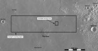
Update on Chang'E 5 landing site selection. Not at LPSC, but at the European Geoscience meeting in April:
http://meetingorganizer.copernicus.org/EGU...GU2017-2026.pdf Summarizing, the pre-selected landing region for CE-5 extends from 41 degrees to 45 degrees N and 49 degrees to 69 W, in northern Oceanus Procellarum west of Montes Jura and north of Mons Rümker. After an analysis of the topography and geologic units, seven sites were shortlisted, in the vicinity of 43 N, 55 W. This is in an area of younger basalts, probably younger than anything sampled before. A significant bit of science. Here's a map of the area:
Phil -------------------- ... because the Solar System ain't gonna map itself.
Also to be found posting similar content on https://mastodon.social/@PhilStooke NOTE: everything created by me which I post on UMSF is considered to be in the public domain (NOT CC, public domain) |
|
|
|
|
|
|
Mar 2 2017, 12:59 AM
Post
#97
|
||
|
Solar System Cartographer Group: Members Posts: 10145 Joined: 5-April 05 From: Canada Member No.: 227 |
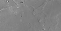
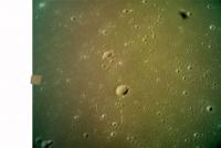
And a closer view of the target area - it's the smooth patch in the middle of this scene.
Phil
-------------------- ... because the Solar System ain't gonna map itself.
Also to be found posting similar content on https://mastodon.social/@PhilStooke NOTE: everything created by me which I post on UMSF is considered to be in the public domain (NOT CC, public domain) |
|
|
|
|
|
|
Mar 2 2017, 02:36 PM
Post
#98
|
|
|
Member Group: Members Posts: 540 Joined: 17-November 05 From: Oklahoma Member No.: 557 |
QUOTE (Phil Stooke @ Mar 1 2017, 06:44 PM) This is in an area of younger basalts, probably younger than anything sampled before. I was hoping for that. |
|
|
|
|
Mar 2 2017, 06:50 PM
Post
#99
|
||
|
Solar System Cartographer Group: Members Posts: 10145 Joined: 5-April 05 From: Canada Member No.: 227 |
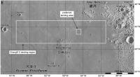
An updated map of the landing area.
Phil
-------------------- ... because the Solar System ain't gonna map itself.
Also to be found posting similar content on https://mastodon.social/@PhilStooke NOTE: everything created by me which I post on UMSF is considered to be in the public domain (NOT CC, public domain) |
|
|
|
|
|
|
Mar 6 2017, 04:25 AM
Post
#100
|
||
|
Solar System Cartographer Group: Members Posts: 10145 Joined: 5-April 05 From: Canada Member No.: 227 |
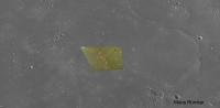
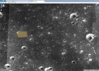
And finally, to show that the precursor mission Chang'E 5 T1 actually did image the landing area, here is the location of one of its images:
(west of the preferred landing area, NW of Mons Rumker, at 43 N, 61 W or 299 E) Phil -------------------- ... because the Solar System ain't gonna map itself.
Also to be found posting similar content on https://mastodon.social/@PhilStooke NOTE: everything created by me which I post on UMSF is considered to be in the public domain (NOT CC, public domain) |
|
|
|
|
|
|
Mar 15 2017, 02:20 PM
Post
#101
|
|
|
Solar System Cartographer Group: Members Posts: 10145 Joined: 5-April 05 From: Canada Member No.: 227 |
I have located the second image now, on the western edge of the first one at 42.763 N, 61.120 W. I will post a graphic when I have time.
Phil -------------------- ... because the Solar System ain't gonna map itself.
Also to be found posting similar content on https://mastodon.social/@PhilStooke NOTE: everything created by me which I post on UMSF is considered to be in the public domain (NOT CC, public domain) |
|
|
|
|
Mar 15 2017, 03:46 PM
Post
#102
|
||||
|
Solar System Cartographer Group: Members Posts: 10145 Joined: 5-April 05 From: Canada Member No.: 227 |
CE5-T1 second image located.
Phil
Attached thumbnail(s)
-------------------- ... because the Solar System ain't gonna map itself.
Also to be found posting similar content on https://mastodon.social/@PhilStooke NOTE: everything created by me which I post on UMSF is considered to be in the public domain (NOT CC, public domain) |
|||
|
|
|
|||
|
Jun 22 2017, 05:13 AM
Post
#103
|
|
|
Solar System Cartographer Group: Members Posts: 10145 Joined: 5-April 05 From: Canada Member No.: 227 |
I have learned some new things about the CE5 landing site. The EGU abstract I linked to higher up on this page defined the large landing area and described a preferred area where seven sites had been 'shortlisted'. Shortlisted was my word, they only referred to them as possible sites in the abstract. The lead author of that abstract has now advised me that the seven sites are just suggestions at this stage, and they are spread over a larger area than my map suggests, but all in the eastern half of the main landing area (i.e all in the younger basalt unit). These sites will be or have been transmitted to the mission management and a final selection will be announced nearer the launch date. I did not see the presentation at EGU and nobody who did seems to have filled in any more details in tweets etc.
-------------------- ... because the Solar System ain't gonna map itself.
Also to be found posting similar content on https://mastodon.social/@PhilStooke NOTE: everything created by me which I post on UMSF is considered to be in the public domain (NOT CC, public domain) |
|
|
|
|
Jun 23 2017, 12:52 AM
Post
#104
|
||
|
Solar System Cartographer Group: Members Posts: 10145 Joined: 5-April 05 From: Canada Member No.: 227 |
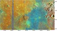
More on those sites later. Meanwhile, here's something I am putting together for a blog post. Clementine color ratio superimposed on the map I made earlier. The gray strip is missing Clementine data. A few small data gaps elsewhere have been cosmetically patched (since this product is not for scientific analysis). The landing site will be in the blue unit.
Phil
-------------------- ... because the Solar System ain't gonna map itself.
Also to be found posting similar content on https://mastodon.social/@PhilStooke NOTE: everything created by me which I post on UMSF is considered to be in the public domain (NOT CC, public domain) |
|
|
|
|
|
|
Jul 2 2017, 04:45 PM
Post
#105
|
|
|
Solar System Cartographer Group: Members Posts: 10145 Joined: 5-April 05 From: Canada Member No.: 227 |
Sad news. A second launch of the large new rocket which is needed for Chang'E 5 has just failed. It seems inevitable that another test - or even two - will be needed before CE5 can be launched, pushing it back well into next year.
Phil -------------------- ... because the Solar System ain't gonna map itself.
Also to be found posting similar content on https://mastodon.social/@PhilStooke NOTE: everything created by me which I post on UMSF is considered to be in the public domain (NOT CC, public domain) |
|
|
|
|

|
Lo-Fi Version | Time is now: 16th April 2024 - 07:03 AM |
|
RULES AND GUIDELINES Please read the Forum Rules and Guidelines before posting. IMAGE COPYRIGHT |
OPINIONS AND MODERATION Opinions expressed on UnmannedSpaceflight.com are those of the individual posters and do not necessarily reflect the opinions of UnmannedSpaceflight.com or The Planetary Society. The all-volunteer UnmannedSpaceflight.com moderation team is wholly independent of The Planetary Society. The Planetary Society has no influence over decisions made by the UnmannedSpaceflight.com moderators. |
SUPPORT THE FORUM Unmannedspaceflight.com is funded by the Planetary Society. Please consider supporting our work and many other projects by donating to the Society or becoming a member. |
|