Traverse to the Delta, sols 379-414, 15 Mar 2022- 21 Apr 2022 |

  |
Traverse to the Delta, sols 379-414, 15 Mar 2022- 21 Apr 2022 |
 Apr 1 2022, 05:48 AM Apr 1 2022, 05:48 AM
Post
#46
|
|
|
Member  Group: Members Posts: 233 Joined: 14-January 22 Member No.: 9140 |
On the third image of Sean's post #39, the MZL_00388 panorama, there is a dark downslope flow material that looks a little like the gullies seen elsewhere. Perhaps these are much smaller, different, and just dust, but they are eye-catching. I don't think we've seen anything like this on Mars before from the ground.
|
 |
 
|
|
Apr 1 2022, 11:36 AM
Post
#47
|
||
 Member Group: Members Posts: 670 Joined: 9-May 21 From: Germany Member No.: 9017 |
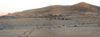
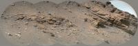
Sol 395 Mastcam-Z panorama with enhanced colors
The prominent cliff behind the rounded hill on the left is part of the delta. So-called "northern fan deposits" are visible behind this cliff in the distance and to the right.
|
|
|
|
|
|
|
Apr 1 2022, 01:05 PM
Post
#48
|
|
|
Member Group: Members Posts: 923 Joined: 10-November 15 Member No.: 7837 |
Preliminary shots from 395...
        -------------------- |
|
|
|
|
Apr 1 2022, 02:29 PM
Post
#49
|
||
|
Member Group: Members Posts: 670 Joined: 9-May 21 From: Germany Member No.: 9017 |
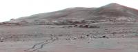
Sol 395 Mastcam-Z looking east. Colors enhanced.
Port Angeles crater with layered outcrops on the inner slope. The hills in the background are probably heavily eroded remnants of delta sediments. Curvilinear layers are faintly visible on the slopes. Distance from the rover about 2.4 to 3 km. The rock on the far left behind the hillside is a small variant of Kodiak hill, distance about 3.3 km.
Edit: Corrected the name of the crater |
|
|
|
|
|
|
Apr 1 2022, 05:07 PM
Post
#50
|
||
|
Member Group: Members Posts: 670 Joined: 9-May 21 From: Germany Member No.: 9017 |
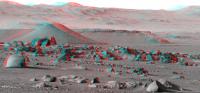
Sol 395 anaglyph Mastcam-Z looking north
|
|
|
|
|
|
|
Apr 2 2022, 05:25 AM
Post
#51
|
|
 Senior Member Group: Members Posts: 1088 Joined: 19-February 05 From: Close to Meudon Observatory in France Member No.: 172 |
QUOTE (tau @ Apr 1 2022, 01:36 PM)  Sol 395 Mastcam-Z panorama with enhanced colors The prominent cliff behind the rounded hill on the left is part of the delta. So-called "northern fan deposits" are visible behind this cliff in the distance and to the right. Very nice Tau 
|
|
|
|
|
Apr 2 2022, 01:24 PM
Post
#52
|
||
|
Member Group: Members Posts: 670 Joined: 9-May 21 From: Germany Member No.: 9017 |
Crater Port Angeles and Perseverance's tracks on sol 395 in stereo.
Best seen on displays with extended color space, wide gamut, AdobeRGB, or similar. Ghosting or double images in the left eye (red filter) are unavoidable on sRGB displays. The ghosting can be reduced by attenuating the green channel of the image, but then the image takes on a distracting purple tint.
Edit: Corrected the name of the crater |
|
|
|
|
|
|
Apr 3 2022, 08:32 PM
Post
#53
|
|
|
Member Group: Members Posts: 282 Joined: 18-June 04 Member No.: 84 |
Another safe mode event??
|
|
|
|
|
Apr 4 2022, 06:35 AM
Post
#54
|
|
|
Solar System Cartographer Group: Members Posts: 10164 Joined: 5-April 05 From: Canada Member No.: 227 |
Was the first one a safe mode? I hadn't heard anything about it. That would certainly be a reasonable explanation.
Phil -------------------- ... because the Solar System ain't gonna map itself.
Also to be found posting similar content on https://mastodon.social/@PhilStooke Maps for download (free PD: https://upload.wikimedia.org/wikipedia/comm...Cartography.pdf NOTE: everything created by me which I post on UMSF is considered to be in the public domain (NOT CC, public domain) |
|
|
|
|
Apr 4 2022, 07:31 AM
Post
#55
|
|
|
Solar System Cartographer Group: Members Posts: 10164 Joined: 5-April 05 From: Canada Member No.: 227 |
We just got several sols worth of images dumped on the server (thanks a lot Percy, I'm supposed to be working...).
Phil -------------------- ... because the Solar System ain't gonna map itself.
Also to be found posting similar content on https://mastodon.social/@PhilStooke Maps for download (free PD: https://upload.wikimedia.org/wikipedia/comm...Cartography.pdf NOTE: everything created by me which I post on UMSF is considered to be in the public domain (NOT CC, public domain) |
|
|
|
|
Apr 4 2022, 09:27 AM
Post
#56
|
||
|
Member Group: Members Posts: 670 Joined: 9-May 21 From: Germany Member No.: 9017 |
Sol 397 SuperCam Remote Micro-Imager mosaic no. 1 of delta sediments
|
|
|
|
|
|
|
Apr 4 2022, 10:06 AM
Post
#57
|
|
|
Member Group: Members Posts: 233 Joined: 14-January 22 Member No.: 9140 |
This SuperCam image, like details seen in the Post #39 panorama, shows the downslope flow of what might be a very fine dark dust that seems to originate from the face of the sedimentary layers. For it to overlay the usually ubiquitous brighter airborne dust would seem to indicate a substantial rate of new generation of whatever this dark stuff is. It, again, is reminiscent of what on much larger scales is seen in gullies which raises, again, the question of whether dark downslope flow is purely dust, or is there some H2O involved? Otherwise, it seems like some of the darker rock is eroding at a considerable rate in the present time. Otherwise, how could these dark trails not be covered with the baseline of brighter martian dust?
|
|
|
|
|
Apr 4 2022, 10:38 AM
Post
#58
|
||
|
Member Group: Members Posts: 670 Joined: 9-May 21 From: Germany Member No.: 9017 |
Sol 397 SuperCam Remote Micro-Imager mosaic no. 2 of delta sediments
|
|
|
|
|
|
|
Apr 4 2022, 03:15 PM
Post
#59
|
|
|
Senior Member Group: Members Posts: 2517 Joined: 13-September 05 Member No.: 497 |
QUOTE (Phil Stooke @ Apr 3 2022, 11:35 PM) Was the first one a safe mode? I hadn't heard anything about it. That would certainly be a reasonable explanation. I believe Steve Ruff mentioned that in his most recent episode on Youtube. https://www.youtube.com/c/MarsGuy Most people aren't authorized to discuss mission ops publicly because of project rules. In general, I think there would be a press release about a major outage or problem, but a minor one might well go unmentioned. -------------------- Disclaimer: This post is based on public information only. Any opinions are my own.
|
|
|
|
|
Apr 4 2022, 03:54 PM
Post
#60
|
||
|
Junior Member Group: Members Posts: 75 Joined: 8-July 15 Member No.: 7566 |
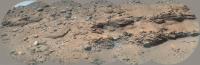
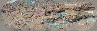
Thank you for the image, Tau. This particular image got my inner sedimentologist very excited, I'm sure it'll be the subject of several publications. I made a quick annotated version showing my preliminary interpretations. Essentially I interpret this conglomerate deposit as a high energy flash flood deposit during an interval when lake levels lowered. The sheer size of the clasts transported (the largest is ~1m across, based on an LPSC abstract which studied lower res images of this same outcrop) requires a powerful flood to transport them, and the high degree of rounding of the clasts suggests they were transported quite some distance. Given that the clasts appear to be several different colours and so lithologies, this agrees with the long distance idea. I suspect they were sourced from outside the crater, and so potentially have travelled many km, and could represent basement materials. The deposit itself is not sheet-like and continuous but instead appears channelised and pinches out, so perhaps the flood followed a pre-existing (dried up?) river channel. The return of delta sandstones above it might indicate a rise in lake level. There are curious discontinuous patches of bright angular 'bits' embedded with this sandstone & I'm not sure what they are, marked in pink. The presence of eroded-out rounded boulders stratigraphically higher, towards the delta top, indicates there was at least one other flash flood deposit later on, so this was not an isolated event. Hopefully there are conglomerate deposits where the rover will be traversing when it climbs up and onto the delta in a few weeks. Because if I'm right, and these rounded clasts represent distant lithologies from the Jezero watershed, then they could be ancient (Noachian) basement rocks which would be a very high priority for sample return. |
|
|
|
|
|
|

|
Lo-Fi Version | Time is now: 22nd May 2024 - 01:31 PM |
|
RULES AND GUIDELINES Please read the Forum Rules and Guidelines before posting. IMAGE COPYRIGHT |
OPINIONS AND MODERATION Opinions expressed on UnmannedSpaceflight.com are those of the individual posters and do not necessarily reflect the opinions of UnmannedSpaceflight.com or The Planetary Society. The all-volunteer UnmannedSpaceflight.com moderation team is wholly independent of The Planetary Society. The Planetary Society has no influence over decisions made by the UnmannedSpaceflight.com moderators. |
SUPPORT THE FORUM Unmannedspaceflight.com is funded by the Planetary Society. Please consider supporting our work and many other projects by donating to the Society or becoming a member. |
|