Rev 126 - Feb 4-22, 2010 - Mimas (main target), Tethys, Iapetus, Calypso and mutual events too |

 Unmanned Spaceflight.com > Outer Solar System > Saturn > Cassini Huygens > Cassini's ongoing mission and raw images
  |
Rev 126 - Feb 4-22, 2010 - Mimas (main target), Tethys, Iapetus, Calypso and mutual events too |
 Feb 19 2010, 10:43 PM Feb 19 2010, 10:43 PM
Post
#91
|
|||
 Senior Member  Group: Members Posts: 1630 Joined: 5-March 05 From: Boulder, CO Member No.: 184 |
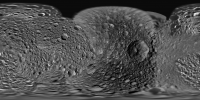
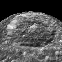
CAP-Team - my first step in updating the map is using a more full disk low-phase image as can be seen here:
VP - I'm using these three triaxial dimensions: 414.8 394.4 381.4. Good question about the fit as Mimas is a great test of our handling of triaxial ellipsoids. Here is a look at the degree of fit (and size relative to the limb) with the image I'm using:
How nice to have Saturn backlighting & highlighting the dark limb, right where this is needed  Steve |
||
 |
 
|
||
|
Feb 19 2010, 11:48 PM
Post
#92
|
|
 Senior Member Group: Moderator Posts: 3233 Joined: 11-February 04 From: Tucson, AZ Member No.: 23 |
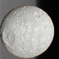
Well, the issue that I have is that my Herschel comes out looking oblong in the north-south direction, which I think it should..., but it pushes some of the craters north and south of Herschel closer to the poles than what is shown in the map on your website.
-------------------- &@^^!% Jim! I'm a geologist, not a physicist!
The Gish Bar Times - A Blog all about Jupiter's Moon Io |
|
|
|
|
Feb 20 2010, 01:19 AM
Post
#93
|
|
|
Solar System Cartographer Group: Members Posts: 10157 Joined: 5-April 05 From: Canada Member No.: 227 |
Sounds like the dreaded Peters Projection! Seriously, is it a map projection mismatch?
Phil -------------------- ... because the Solar System ain't gonna map itself.
Also to be found posting similar content on https://mastodon.social/@PhilStooke Maps for download (free PD: https://upload.wikimedia.org/wikipedia/comm...Cartography.pdf NOTE: everything created by me which I post on UMSF is considered to be in the public domain (NOT CC, public domain) |
|
|
|
|
Feb 20 2010, 02:44 PM
Post
#94
|
||
|
Senior Member Group: Members Posts: 1630 Joined: 5-March 05 From: Boulder, CO Member No.: 184 |
Perhaps VP is working with a planetographic map as I think that corresponds with an oblong appearance for Herschel. The official maps on the CICLOPS site also appear to be planetographic. Conversely I am working with planetocentric coordinates (still on the triaxial ellipsoid), where Hershel should probably look more round.
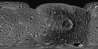
It appears possible to convert between planetocentric and planetographic. One way (at least for the latitude part) might be the reverse of what is discussed below: https://isis.astrogeology.usgs.gov/IsisSupp...hp?topic=1550.0 Here BTW is a map using three images from the new flyby.
Steve P.S. I recall running into the Peters projection on another project, thankfully not this one! |
|
|
|
|
|
|
Feb 20 2010, 08:23 PM
Post
#95
|
|
 IMG to PNG GOD Group: Moderator Posts: 2250 Joined: 19-February 04 From: Near fire and ice Member No.: 38 |
Looks great even though the contrast stretch is a bit extreme for my taste (completely black shadows in craters etc.). Is the automatic contrast stretch applied to the source images one of the reasons for this?
|
|
|
|
|
Feb 20 2010, 08:32 PM
Post
#96
|
||
|
Senior Member Group: Members Posts: 1630 Joined: 5-March 05 From: Boulder, CO Member No.: 184 |
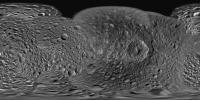
Bjorn - yes it's true this looks quite a bit more contrasty and darker compared with say my Enceladus map. For Mimas many of the first images on the map were at higher phase angles. That coupled with such a battered surface tended to give a preponderance of shadowed craters. This kind of became the norm for contrast when newer images are added. New images at low phase thus have to be contrast stretched quite a bit to look consistent. Nonetheless it appears to be a good suggestion and I will try to soften the shadows (and avoid losing details) with some of the imagery.
Here's a slightly less contrasty 4K version:
Steve |
|
|
|
|
|
|
Feb 20 2010, 09:31 PM
Post
#97
|
|
|
Member Group: Members Posts: 102 Joined: 29-January 10 From: Poland Member No.: 5205 |
Steve, what software you use to making maps? I searched Google and nothing..
-------------------- Adam Hurcewicz from Poland
|
|
|
|
|
Feb 20 2010, 10:15 PM
Post
#98
|
|
|
Senior Member Group: Members Posts: 1630 Joined: 5-March 05 From: Boulder, CO Member No.: 184 |
Adam - I'm using IDL. Using this software I wrote various procedures that help me navigate images, handle the map projections, and do the mapping.
Steve |
|
|
|
|
Feb 21 2010, 02:15 PM
Post
#99
|
||
|
Member Group: Members Posts: 102 Joined: 29-January 10 From: Poland Member No.: 5205 |
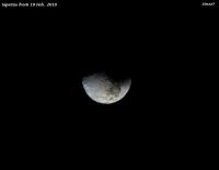
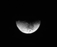
Iapetus color image (19 Feb. 2010)
N00151720.jpg ® N00151716.jpg (G) N00151719.jpg ( 
Attached thumbnail(s)
-------------------- Adam Hurcewicz from Poland
|
|
|
|
|
|
|
Feb 21 2010, 09:48 PM
Post
#100
|
||
 Administrator Group: Admin Posts: 5172 Joined: 4-August 05 From: Pasadena, CA, USA, Earth Member No.: 454 |
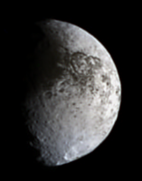
Nice! Here's my version
 Used all the images, stacked to attempt to reduce JPEG artifacts, enlarged 200%. Used all the images, stacked to attempt to reduce JPEG artifacts, enlarged 200%.
Attached thumbnail(s)
-------------------- My website - My Patreon - @elakdawalla on Twitter - Please support unmannedspaceflight.com by donating here.
|
|
|
|
|
|
|
Feb 22 2010, 02:25 PM
Post
#101
|
||
|
Member Group: Members Posts: 102 Joined: 29-January 10 From: Poland Member No.: 5205 |
Here is Iapetus animation from 4 images: http://saturn.jpl.nasa.gov/photos/raw/rawi...?imageID=213904 http://saturn.jpl.nasa.gov/multimedia/imag...7/N00151741.jpg http://saturn.jpl.nasa.gov/photos/raw/rawi...?imageID=213887 http://saturn.jpl.nasa.gov/multimedia/imag...7/N00151724.jpg http://saturn.jpl.nasa.gov/photos/raw/rawi...?imageID=213862 http://saturn.jpl.nasa.gov/multimedia/imag...7/N00151699.jpg http://saturn.jpl.nasa.gov/photos/raw/rawi...?imageID=213833 http://saturn.jpl.nasa.gov/multimedia/imag...7/N00151670.jpg -------------------- Adam Hurcewicz from Poland
|
|
|
|
|
|
|
Feb 24 2010, 12:01 AM
Post
#102
|
||
|
IMG to PNG GOD Group: Moderator Posts: 2250 Joined: 19-February 04 From: Near fire and ice Member No.: 38 |
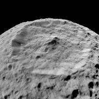
Using Steve's updated map of Mimas I made a quick and dirty shape from shading (SFS) DEM and combined it with my earlier DEM of Mimas created using stereo imagery (see this thread for more information on these 'combined DEMs'). The stereo DEM itself hasn't been updated with the new data (I don't expect to update it until this data hits the PDS) so the resulting stereo+SFS DEM is not accurate - this is a test render:
This image has a field of view of 45° and the altitude above the surface is ~125 km. There is some longitudinal striping that I managed to partially hide by carefully selecting the light source location. I'm using a uniform white map for a texture map so all of the details come from the DEM. |
|
|
|
|
|
|
Feb 24 2010, 12:42 AM
Post
#103
|
|
|
Administrator Group: Admin Posts: 5172 Joined: 4-August 05 From: Pasadena, CA, USA, Earth Member No.: 454 |
Bjorn, it's very hard to mosaic the Mimas images because Cassini was moving so fast that the perspective shifted markedly from frame to frame. But "official" mosaics are also lacking because when they reproject the images they do so onto an ellipsoid, which destroys limb topography in the resulting mosaic. Will your DEM of Mimas eventually enable you to reproject Cassini images onto an appropriately lumpy body, producing Mimas "mosaics" (maybe should call them "rendered mosaics") that have proper limb topography?
-------------------- My website - My Patreon - @elakdawalla on Twitter - Please support unmannedspaceflight.com by donating here.
|
|
|
|
|
Feb 24 2010, 01:08 AM
Post
#104
|
||
|
IMG to PNG GOD Group: Moderator Posts: 2250 Joined: 19-February 04 From: Near fire and ice Member No.: 38 |
Yes, the DEM enables this and the accuracy of the resulting images/"mosaics" depends solely on the accuracy of the DEM. An annoying problem/artifact is the east-west striping and in this case the stereo DEM also is very crude as previously noted. Here is a test render where Steve's map has been draped over the DEM without applying any shading:
The viewing geometry is the same as previously. This reveals that some of the DEM's topography may be due to albedo variations in the source map and not due to topographic shading. 'Blinking' these two images is rather interesting. |
|
|
|
|
|
|
Feb 24 2010, 06:26 AM
Post
#105
|
||
 SewingMachine Group: Members Posts: 316 Joined: 27-September 05 From: Seattle Member No.: 510 |
Always so much to catch up on...fantastic DEM perspectives, Bjorn. That's a scene I've had in my imagination for ages, finally made real. Your map is beautiful as always, Steve. I'd like to suggest possibly using images from the 28 June 2007 pass for detail west of Herschel and the transition to the coverage from August 2005. The fine fractures and/or crater chains show up much better, and it seems to beat the resolution of the partial Voyager coverage. I'm reposting Gordan's excellent color version for reference. You're all awesome. Belated welcome to Adam too!
ugordan's Mimas 28/06/07:
-------------------- ...if you don't like my melody, i'll sing it in a major key, i'll sing it very happily. heavens! everybody's all aboard? let's take it back to that minor chord...
Exploitcorporations on Flickr (in progress) : https://www.flickr.com/photos/135024395@N07/ |
|
|
|
|
|
|

|
Lo-Fi Version | Time is now: 4th May 2024 - 09:20 AM |
|
RULES AND GUIDELINES Please read the Forum Rules and Guidelines before posting. IMAGE COPYRIGHT |
OPINIONS AND MODERATION Opinions expressed on UnmannedSpaceflight.com are those of the individual posters and do not necessarily reflect the opinions of UnmannedSpaceflight.com or The Planetary Society. The all-volunteer UnmannedSpaceflight.com moderation team is wholly independent of The Planetary Society. The Planetary Society has no influence over decisions made by the UnmannedSpaceflight.com moderators. |
SUPPORT THE FORUM Unmannedspaceflight.com is funded by the Planetary Society. Please consider supporting our work and many other projects by donating to the Society or becoming a member. |
|