geology of Gale Crater and Mount Sharp |

geology of Gale Crater and Mount Sharp |
 Jun 21 2014, 01:49 PM Jun 21 2014, 01:49 PM
Post
#1
|
|
|
Junior Member  Group: Members Posts: 33 Joined: 16-June 14 From: Sweet Home, Oregon Member No.: 7202 |
The idea that the Lower Formation of Mt. Sharp is of lacustrine origin (lakebed sediments) has rather fallen out of favor recently, but I just finished my essay on Mars, "An Interpretation of the Geology of Gale Crater & Mount Sharp, with Implications for the History & Habitability of Mars," which I have spent over one year researching and writing, and the primary thrust of this paper is to offer a fresh defense of the lacustrine model, incorporating some fairly original ideas on my part. I'm not a professional scientist, but this is a labor of love that springs from a near-lifelong interest in Mars (since I was a young boy in the 1960s). And I'm trying to publicize it prior to Curiosity reaching Mt. Sharp, as that will be a test of my theories, and I'm hoping to get some recognition if I'm right. So here's the link for all interested readers: http://galecratergeology1.tumblr.com/post/...le-crater-mount
|
 |
 
|
 |
|
Jul 3 2014, 05:09 AM
Post
#2
|
|
|
Senior Member Group: Members Posts: 1043 Joined: 17-February 09 Member No.: 4605 |
Apply Kite's model to the massive, upper stage of Mount Sharps formation and it fits very well indeed. It would probably be best if you couched your statements as beliefs as opposed to facts. For example you may believe that "the entire Gale/Mt. Sharp complex (the mountain, the crater floor, and the crater rim) shows unmistakable signs of repeated aqueous events (as well as glacial and periglacial activity) over a very long time". There is no wide agreement on that, nor definitive evidence, so the statement is your interpretation, not a fact. You have a deep belief in your high pressure aquifer release hypothesis as the cause of the channels but again, that is a personal belief rather than a fact. If you want to explain Gale topography as the product of a wide area, high pressure aquifer then you need to marshal some defensible arguments in the context of the region. Try considering the possibility that the volcanic activity /uplift involved an ambulatory process and think about the flooding effect and ocean rise if the volcanic activity was coincident with an existing ocean. Pointing to Cerberus Fossae and saying here be the aquifer is drawing an exceedingly long bow. Explain why the release occurred in the central mountain and not the equally fractured crater walls or the low terrain to the North.
|
|
|
|
|
Jul 3 2014, 12:11 PM
Post
#3
|
|||
|
Junior Member Group: Members Posts: 33 Joined: 16-June 14 From: Sweet Home, Oregon Member No.: 7202 |
Reply to Serpens:
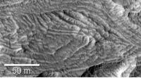
There is quite a lot of ground to cover here. I disagree with your interpretation of the headwater of the Grand Canyon....you state that it doesn't narrow prior to disappearing at the bottom edge of the Upper Formation (the implication being that if it were not in unconformable relation with the Upper Formation and buried by that formation, it should pinch out to a narrow gully prior to disappearing)....but I believe that the reason for this is that the visible channel never was the conduit for water that proceeded to flow down the Grand Canyon. Such a conclusion is suggested by the fact that this "headwater channel" is too small a channel (it has too small a cross-sectional area) to have contained the huge flow required to cut the Grand Canyon, move ten-meter-wide boulders, and deposit the delta at the terminus of that canyon (both its width and depth are a small fraction of the dimensions of the lower canyon). We observe that the channel suddenly changes to a canyon at approximately the 7-mile mark, and this canyon proceeds to widen and deepen as we move downstream, but WITHOUT tributaries that could explain the corresponding flow increase and erosive capability. I would suggest the following as an explanation for this apparent paradox (that the channel had a high flow rate without a headwater or tributaries to support it): although there may have been some flow in the visible headwater channel, what we are interpreting as a channel is primarily a subsidence feature on top of a largely hollowed-out subsurface (which is where most of the flow took place). This is a pattern we see fairly often in Earthly settings, where there is a sudden transition from shallow to deep runoff channel, involving flow through fissures or porosity of the rock beneath what we see as the visible channel, until the bulk of that flow transitions to being surface flow, from springs and general seepage. And I would suggest that we are seeing the first of these (dormant) springs where the channel suddenly deepens (at the 7-mile mark), and that there were additional springs in the canyon floor and walls, augmenting the total flow, as we moved downhill. Support for this model is provided by the occurrence of numerous box canyons in the western lobe of Mt. Sharp, apparently brought about by groundwater sapping from springs, with stubby heads that have been eroded backwards into the mountain (but with no signs of being fed by surface flow), and with termini featuring debris lobes. The "Grand Canyon" simply happens to be the largest of these, and it appears that Mt. Sharp is highly fractured, featuring dormant springs that can become active again under the proper conditions. The fact that the headwater channel doesn't narrow prior to disappearing into the hill, is consistent with the channel being a collapse zone, wherein the rise in the lay of the land as we move further east, eventually creates enough of a roof arch above the subsurface flow to prevent subsidence. As I have previously stated, if the Grand Canyon were the product of overland flow from a substantial distance (across a hypothetical tableland in the eastern portion of Gale), then it would be a deep, wide, mature channel by the time that reached the spot where we see the "headwater" channel, and the Grand Canyon would not be expected to begin with such morphology. Also I find the concept of a tableland in the eastern portion of Gale to be suspect, as there is no obvious way to account for its subsequent erosion, while at the same time the western face of Mt. Sharp remained comparatively unmolested (such that channels and thin delta deposits survived subsequent geologic history). I do not believe that SWEET is able to account for the Upper Formation, the most serious flaw being the extensive cross-bedding (see photo), which could not be the result of the predicted winds, but only of horizontal winds, and in any case, a dune field could not be expected to form on top of a mountain, and if it managed to, said horizontal winds would quickly send it packing downslope.
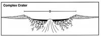
I do not consider Cerberus Fossae irrelevant for understanding Gale. Those outflows show that Mars still has an active aquifer that is under pressure (and one which is capable of reaching the surface), and there is no reason to believe there is any relevant subsurface barrier across the Elysium plains between the two locales, so they should in fact share the same aquifer. To see how water has repeatedly left its mark on the Gale/Mt. Sharp complex, all that is needed is to look at photos of the crater floor (showing multiple generations of fans and channels stacked on top of each other) and photos of the crater rim, showing numerous stream-carved valleys and canyons that were obviously not created by some huge catastrophic Noah-type flood, but over an extended time from innumerable individual events, likely in association with obliquity changes and also volcanic and possibly asteroid-collision events, with the net result being a landscape that looks very much like the Southwest desert terrain of the US (which has also been subject to periodic fluvial events). This is not just an opinion on my part. I consider it highly unlikely that the foothills of Mt. Sharp (and the channels) have had a protective aeolian cover on them that has recently been stripped away, because of the immense damage that such a stripping action would also have delivered to the underlying surface, given that an extension of the Upper Formation would likely require violent stripping action to remove, considering how well-lithified the Upper Formation appears to be.....likely to a comparable degree as the Lower Formation (the implication being that the surface on the lower flank of Mt. Sharp is young, with the channels most recently active several tens of millions of years ago). You stated that we can't really tell the relative state of lithification until Curiosity reaches the deposits, but unfortunately Curiosity will never be able to drive up to the Upper Formation, so we have to make do with HiRISE imagery, which indicates that the Upper Formation is fairly erosion-resistant. And if indeed it is an outlier of the Medusa Fossae formation, as seems likely, the upper mound must be well-lithified indeed, to have survived an erosional environment that has removed all other local exposures of that formation, including at lower levels....and that fact fits very well within my artesian hydrant model, in that water would have been available to provide a degree of lithification that was highly atypical for the Medusa Fossae. You stated that it is implausible that aquifer outflows would occur in Mt. Sharp but not in the "equally fractured" crater wall, or in the low terrain to the north. I would suggest that aquicludes play the same role in the Northern Plains as they do in the floor of Gale. And as regards the crater rim/wall, I don't see any reason to think that fractures would be deep enough at those locations to reach the aquifer, which would be separated from the surface by at least a mile of basalt and a very solid cryosphere (whereas the fractures would be expected to reach very deeply indeed under the center of the crater). Although I can't vouch for its detailed accuracy, the included figure (courtesy of NASA) shows how there would be deep fractures beneath Gale, but not necessarily in the crater rim/wall.
The reason that I robustly support my Artesian Hydrant hypothesis, is that it seems to account for all empirical observations of the Gale/Mt. Sharp complex, and is also internally coherent logically, whereas there are serious difficulties with all other models I have seen, either in terms of their basic theory or in terms of meshing with the data. Dave |
||
|
|
|
||
|
Jul 3 2014, 01:31 PM
Post
#4
|
|
 Senior Member Group: Admin Posts: 3108 Joined: 21-December 05 From: Canberra, Australia Member No.: 615 |
ADMIN NOTE:
Sorry everyone, I believe that this topic may have run its course. There is no discussion here, only contribution and refusal to hear those contributions. The Admin/Mod team have been more than patient and we will now discuss whether this topic gets re-opened. Contributors to this thread and other members are welcome to send me a direct message and add comment on the course of this discussion or provide valid reasons as to why this topic should continue. |
|
|
|
 David Palmer geology of Gale Crater and Mount Sharp Jun 21 2014, 01:49 PM
 PDP8E Hi David,
What A fact filled first post!
Your... Jun 21 2014, 08:23 PM elakdawalla Hi David, it's clear you've put a lot of w... Jun 23 2014, 03:33 PM
PDP8E Hi David,
What A fact filled first post!
Your... Jun 21 2014, 08:23 PM elakdawalla Hi David, it's clear you've put a lot of w... Jun 23 2014, 03:33 PM
 David Palmer QUOTE (elakdawalla @ Jun 23 2014, 08:33 A... Jun 23 2014, 10:45 PM djellison QUOTE (David Palmer @ Jun 23 2014, 02:45 ... Jun 23 2014, 11:49 PM PDP8E my post (above) seems to have replicated itself...... Jun 23 2014, 09:01 PM elakdawalla Ah, my mistake, I did not notice the list of refer... Jun 24 2014, 12:09 AM djellison QUOTE (elakdawalla @ Jun 23 2014, 04:09 P... Jun 24 2014, 01:20 AM Juramike You've put a huge amount of work into this. I ... Jun 24 2014, 04:05 AM serpens Firstly let me congratulate you David, on the leve... Jun 24 2014, 08:04 AM David Palmer In response to Serpens:
My intention with my essa... Jun 24 2014, 02:08 PM elakdawalla My apologies, I completely misread your intent. Wh... Jun 24 2014, 06:18 PM djellison Of the entire 4 page work - this is the part that ... Jun 24 2014, 08:59 PM mcaplinger QUOTE a green-tinted sky similar to Curiositys...... Jun 24 2014, 09:56 PM David Palmer QUOTE (mcaplinger @ Jun 24 2014, 01:56 PM... Jun 24 2014, 10:43 PM djellison QUOTE (David Palmer @ Jun 24 2014, 02:43 ... Jun 24 2014, 10:51 PM David Palmer QUOTE (djellison @ Jun 24 2014, 12:59 PM)... Jun 24 2014, 11:05 PM fredk mcaplinger beat me - I was going to link to this p... Jun 24 2014, 10:10 PM serpens I think perhaps everyone needs to take a deep brea... Jun 25 2014, 12:30 AM David Palmer reply to Serpens:
I am very aware of the spring mo... Jun 25 2014, 01:22 AM serpens Dave, I am answering here rather than by email bec... Jun 27 2014, 03:44 AM David Palmer reply to Serpens:
The basis of my argument for the... Jun 27 2014, 04:07 AM Astro0 ADMIN NOTE:
EVERYONE - This discussion is breachi... Jun 25 2014, 01:10 AM vikingmars About the color of the Martian sky : we had alread... Jun 25 2014, 02:45 PM David Palmer reply to vikingmars ("About the color of the ... Jun 27 2014, 09:35 AM vikingmars QUOTE (David Palmer @ Jun 27 2014, 11:35 ... Jun 30 2014, 02:49 PM scalbers I can point here to my post in another thread, whe... Jun 29 2014, 06:40 PM marsophile Given the wide variation in the amount of dust, pe... Jun 30 2014, 04:02 AM mcaplinger QUOTE (marsophile @ Jun 29 2014, 09:02 PM... Jun 30 2014, 05:16 AM serpens QUOTE (mcaplinger @ Jun 30 2014, 06:16 AM... Jun 30 2014, 05:49 AM Astro0 ADMIN NOTE: All, as noted a few posts earlier, let... Jun 30 2014, 10:56 PM serpens The more I look at the "headwaters" of t... Jul 1 2014, 06:09 AM David Palmer Reply to Serpens:
Your hypothesis (which we can c... Jul 1 2014, 09:10 AM Gerald QUOTE (David Palmer @ Jul 1 2014, 11:10 A... Jul 1 2014, 12:26 PM serpens I have a little difficulty with some of the assump... Jul 1 2014, 02:56 PM David Palmer Reply to Serpens:
Actually, I WANT "argument... Jul 1 2014, 09:33 PM ngunn QUOTE (David Palmer @ Jul 1 2014, 10:33 P... Jul 1 2014, 10:09 PM Gerald QUOTE (David Palmer @ Jul 1 2014, 11:33 P... Jul 1 2014, 11:12 PM David Palmer Reply to Gerald:
It is beyond my means to do a co... Jul 2 2014, 07:43 AM Gerald Picking out a couple of statements:
QUOTE (David P... Jul 2 2014, 12:12 PM David Palmer Reply to Gerald (my comments are in upper case): A... Jul 2 2014, 01:59 PM mcaplinger QUOTE (David Palmer @ Jul 1 2014, 02:33 P... Jul 2 2014, 03:13 PM David Palmer QUOTE (mcaplinger @ Jul 2 2014, 07:13 AM)... Jul 2 2014, 03:29 PM Gerald QUOTE (David Palmer @ Jul 2 2014, 05:29 P... Jul 2 2014, 05:30 PM David Palmer Reply to Gerald:
No, I did mean what I said, that... Jul 3 2014, 02:48 AM serpens ngunn provides some sage advice above. I commend ... Jul 2 2014, 02:52 PM serpens A slight aside. I wonder at the validity of using... Jul 2 2014, 11:17 PM Gerald That's why I would prefer to wait for more rel... Jul 3 2014, 12:20 AM David Palmer Reply to dialogue between Serpens and Gerald:
I d... Jul 3 2014, 03:36 AM
David Palmer QUOTE (elakdawalla @ Jun 23 2014, 08:33 A... Jun 23 2014, 10:45 PM djellison QUOTE (David Palmer @ Jun 23 2014, 02:45 ... Jun 23 2014, 11:49 PM PDP8E my post (above) seems to have replicated itself...... Jun 23 2014, 09:01 PM elakdawalla Ah, my mistake, I did not notice the list of refer... Jun 24 2014, 12:09 AM djellison QUOTE (elakdawalla @ Jun 23 2014, 04:09 P... Jun 24 2014, 01:20 AM Juramike You've put a huge amount of work into this. I ... Jun 24 2014, 04:05 AM serpens Firstly let me congratulate you David, on the leve... Jun 24 2014, 08:04 AM David Palmer In response to Serpens:
My intention with my essa... Jun 24 2014, 02:08 PM elakdawalla My apologies, I completely misread your intent. Wh... Jun 24 2014, 06:18 PM djellison Of the entire 4 page work - this is the part that ... Jun 24 2014, 08:59 PM mcaplinger QUOTE a green-tinted sky similar to Curiositys...... Jun 24 2014, 09:56 PM David Palmer QUOTE (mcaplinger @ Jun 24 2014, 01:56 PM... Jun 24 2014, 10:43 PM djellison QUOTE (David Palmer @ Jun 24 2014, 02:43 ... Jun 24 2014, 10:51 PM David Palmer QUOTE (djellison @ Jun 24 2014, 12:59 PM)... Jun 24 2014, 11:05 PM fredk mcaplinger beat me - I was going to link to this p... Jun 24 2014, 10:10 PM serpens I think perhaps everyone needs to take a deep brea... Jun 25 2014, 12:30 AM David Palmer reply to Serpens:
I am very aware of the spring mo... Jun 25 2014, 01:22 AM serpens Dave, I am answering here rather than by email bec... Jun 27 2014, 03:44 AM David Palmer reply to Serpens:
The basis of my argument for the... Jun 27 2014, 04:07 AM Astro0 ADMIN NOTE:
EVERYONE - This discussion is breachi... Jun 25 2014, 01:10 AM vikingmars About the color of the Martian sky : we had alread... Jun 25 2014, 02:45 PM David Palmer reply to vikingmars ("About the color of the ... Jun 27 2014, 09:35 AM vikingmars QUOTE (David Palmer @ Jun 27 2014, 11:35 ... Jun 30 2014, 02:49 PM scalbers I can point here to my post in another thread, whe... Jun 29 2014, 06:40 PM marsophile Given the wide variation in the amount of dust, pe... Jun 30 2014, 04:02 AM mcaplinger QUOTE (marsophile @ Jun 29 2014, 09:02 PM... Jun 30 2014, 05:16 AM serpens QUOTE (mcaplinger @ Jun 30 2014, 06:16 AM... Jun 30 2014, 05:49 AM Astro0 ADMIN NOTE: All, as noted a few posts earlier, let... Jun 30 2014, 10:56 PM serpens The more I look at the "headwaters" of t... Jul 1 2014, 06:09 AM David Palmer Reply to Serpens:
Your hypothesis (which we can c... Jul 1 2014, 09:10 AM Gerald QUOTE (David Palmer @ Jul 1 2014, 11:10 A... Jul 1 2014, 12:26 PM serpens I have a little difficulty with some of the assump... Jul 1 2014, 02:56 PM David Palmer Reply to Serpens:
Actually, I WANT "argument... Jul 1 2014, 09:33 PM ngunn QUOTE (David Palmer @ Jul 1 2014, 10:33 P... Jul 1 2014, 10:09 PM Gerald QUOTE (David Palmer @ Jul 1 2014, 11:33 P... Jul 1 2014, 11:12 PM David Palmer Reply to Gerald:
It is beyond my means to do a co... Jul 2 2014, 07:43 AM Gerald Picking out a couple of statements:
QUOTE (David P... Jul 2 2014, 12:12 PM David Palmer Reply to Gerald (my comments are in upper case): A... Jul 2 2014, 01:59 PM mcaplinger QUOTE (David Palmer @ Jul 1 2014, 02:33 P... Jul 2 2014, 03:13 PM David Palmer QUOTE (mcaplinger @ Jul 2 2014, 07:13 AM)... Jul 2 2014, 03:29 PM Gerald QUOTE (David Palmer @ Jul 2 2014, 05:29 P... Jul 2 2014, 05:30 PM David Palmer Reply to Gerald:
No, I did mean what I said, that... Jul 3 2014, 02:48 AM serpens ngunn provides some sage advice above. I commend ... Jul 2 2014, 02:52 PM serpens A slight aside. I wonder at the validity of using... Jul 2 2014, 11:17 PM Gerald That's why I would prefer to wait for more rel... Jul 3 2014, 12:20 AM David Palmer Reply to dialogue between Serpens and Gerald:
I d... Jul 3 2014, 03:36 AM |

|
Lo-Fi Version | Time is now: 29th April 2024 - 12:36 PM |
|
RULES AND GUIDELINES Please read the Forum Rules and Guidelines before posting. IMAGE COPYRIGHT |
OPINIONS AND MODERATION Opinions expressed on UnmannedSpaceflight.com are those of the individual posters and do not necessarily reflect the opinions of UnmannedSpaceflight.com or The Planetary Society. The all-volunteer UnmannedSpaceflight.com moderation team is wholly independent of The Planetary Society. The Planetary Society has no influence over decisions made by the UnmannedSpaceflight.com moderators. |
SUPPORT THE FORUM Unmannedspaceflight.com is funded by the Planetary Society. Please consider supporting our work and many other projects by donating to the Society or becoming a member. |
|