Printable Version of Topic
Click here to view this topic in its original format
Unmanned Spaceflight.com _ Titan _ Titan topics @ AGU2008
Posted by: titanicrivers Dec 14 2008, 04:42 AM
Titan topics @ AGU 2008
The following links originally posted by E. Lakdawalla in her Planetary Society blog of 12-8-08 takes one to the interesting poster and platform session abstracts to be presented at the AGU this week. Lots of thought provoking topics covering Titan's atmosphere and surface!
http://www.agu.org/cgi-bin/sessions5?meeting=fm08&part=P21A&maxhits=400
http://www.agu.org/cgi-bin/sessions5?meeting=fm08&part=P11D&maxhits=400
http://www.agu.org/cgi-bin/sessions5?meeting=fm08&part=P12A&maxhits=400
Posted by: ngunn Dec 16 2008, 04:44 PM
Ganesa Macula - just a random inkblot?
Thanks for this one Emily.
Disappearing volcano No. 2. (Better find some new ones quick.)
http://www.planetary.org/blog/article/00001771/
Let me guess the reaction here.
Phil will say it was overinterpreted in the first place.
Mike will have a new interpretation posted by midnight.
Seriously, what say all??
Posted by: Juramike Dec 16 2008, 06:19 PM
In one sense the observation that Ganesa is not a dome is almost reassuring.
Since it is circular shaped and doesn't seem constrained by the existing mountain range, likely candidate processes would be impact, a sunken cryocaldera, some sort of collapsed salt-dome equivalent, or sunken diapir blob-thingy, or something really, really funky.
I see a similarity between Mabon Macula, Ganesa Macula, and Menrva:
All three have roughly circular shaped interiors
All three have a RADAR-smoother deposit in the interior region
All three have streams that appear (from the branching pattern) to enter the feature from the outside and flow towards the center (one of the streams of Mabon supposedly drains to the S; I'd hazard that two of the streams in Ganesa flow inwards (at 3 and 9 o'clock) and one might flow outwards (at 5 o'clock))
All three have a RADAR-rougher central region, with a depressed area around this point (from streamflow)
Both Menrva and Ganesa have some sort of bright RADAR alluvial outflow removed from the feature. The source of these both seem to come up from chaotic terrain.
If I had to speculate wildly, I would hazard that all three features are impact features, in various stages of relaxation/burial/erosion.
The central peak could be the remnant of a central peak crater, or it could be something pushed up from a subsurface source activated by the impact. (Like a cryo-plug dome). From the appearance (or lack thereof) of a surrounding rim, I'd further speculate that Mabon Macula is the oldest, with Gansa, then Menrva. (Menrva still shows a nice rim)
Here's a side by side comparing an image of Dilmun Crater to Ganesa Macula:
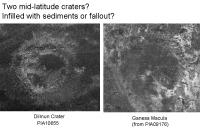
|
-Mike
Posted by: volcanopele Dec 16 2008, 06:49 PM
Or maybe it is just a circular doo-hickey. The human brain is very well suited for finding shapes in what is otherwise a chaotic pattern. Here at Ganesa, we see something that, if we connect some of the features in the region, appears to be circular.
I think the comparison to Mabon is apt. At the center of Ganesa we see a patch of hilly terrain with channels flowing out from these hills. But there is no evidence for a rim and morphology of edge of Ganesa is much more varied and inconsistent compared to known craters of that size on Titan, like Afekan and Guabonito.
Posted by: titanicrivers Dec 17 2008, 07:07 AM
[quote name='ngunn' date='Dec 16 2008, 10:44 AM' post='132761']
Ganesa Macula - just a random inkblot?
Seriously, what say all??
I may have missed something but the abstract of Kirk et al A Three-Dimensional View of Titan's Surface Features from Cassini RADAR Stereogrammetry http://www.agu.org/cgi-bin/wais?mm=P11D-09 seems to suggest the jury is still out on whether Ganesa is a dome or a depression. To quote from their abstract:
We are collecting DTMs of all usable image pairs and will present the most interesting results. Examples of geologic questions that may be addressed are: What is the relation between Ganesa and surrounding features? Is it a dome or shield?
Perhaps the outer portion is a collapsed cryocaldera and the central crater a more recent cryolava vent. This supports Mikes observation of the 3 and 9 oclock channels appearing to flow towards the center while the 5 oclock cryolava channel (which has a different morphology) flows outward from the center.
Posted by: Juramike Dec 17 2008, 12:07 PM
I'm not sure if those are cryolava channels or not.
It could be just a hydrocarbon rain drainage "regular" stream channel filled with blocky rough RADAR-bright debris.
One interesting question though: Why is there a bright streambed sitting on top of apparently smoother uniform terrain?
Where have we seen this before? (rough channels on smooth terrain)
Where have we seen smooth channels in smooth terrain?
Is the smoothness due to the actual surface rock, or is it due to an airfall or other deposit that got blown in (and is thus "non-native")?
Did Ganesa act as a trap for some material that is now obscuring the actual stuff Ganesa was formed in?
-Mike
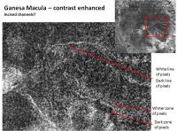
Posted by: Juramike Dec 17 2008, 12:55 PM
Here is an inverted contrast-enhanced section of PIA09176 (Ganesa Macula) to indicate the bright channels (as dark lines):

|
(Why am I suddenly hungry for apple pie?)
-Mike
Posted by: elakdawalla Dec 17 2008, 05:05 PM

The abstract was written long before they'd finished developing their DTMs, so, when he submitted his abstract, the jury was indeed still out. When Randy started his presentation, he apologized to half of the listed coauthors, who were supposed to have advised him on geologic interpretations -- apparently there was no time for advice, as he had only finished producing the maps on the previous Saturday. The answer is that it's neither a dome nor a depression. It's high in some places and low in others with almost no relation to the apparently circular radar-dark shape.
--Emily
Posted by: Juramike Dec 17 2008, 08:24 PM
Which itself is pretty interesting.
If you look at the channel branching pattern (post above), it is extremely radial. A higher level of branching is seen about 2/3 of the way from the center, decreasing nodes as you go towards the center.
This branching pattern would be consistent with a bowl shape and sources around the edges, and steeper slopes at the edge. Or a flat dome shape, with a source at the center and steeper slopes at the edge.
(A typical eroding mountain, with distributed sources (rainfall/snow) hitting the surface, will have a branching pattern with more nodes towards the center of the mountain)
If the topography doesn't match the branching pattern, that may indicate the top layer of stuff was added well after the streams were in place and the order locked in. (Or that the stream pattern was locked in the the terrain rose up into it. Excellent example: the Gates of Lodore at Dinosaur National Monument)
-Mike
Posted by: titanicrivers Dec 17 2008, 10:45 PM
[quote name='elakdawalla' date='Dec 17 2008, 11:05 AM' post='132836']
The abstract was written long before they'd finished developing their DTMs, so, when he submitted his abstract, the jury was indeed still out. ... The answer is that it's neither a dome nor a depression. It's high in some places and low in others with almost no relation to the apparently circular radar-dark shape.
Wow, I should have read your 12/15 Planetary Society blog page first Emily!
It will be interesting to see the completed topo map and learn what the height resolution scale is etc.
Regardless, Ganesa is still an interesting region with channels that are radially oriented and telling us something about the structure.
Posted by: Juramike Dec 18 2008, 03:50 AM
I think portions of the channels might be incised:
|
Note RADAR-dark line parallel and S of the RADAR bright channel at the 3 o'clock position. This is consistent with a channel feature seen outside the Ganesa Macula region (on other side of ridge, N of the brightish alluvial looking things).
This is also consistent with RADAR look direction from the S (looking towards the N; this part of the Ganesa image is derived from the T3 RADAR swath (see: Elachi et al. Science 308 (2005) 970-974))
There is also a branch off the 3 o'clock position trending to the SW (4 o'clock) that displays a darker region S of the channel and the brighter region N of the channel. This might (?) be consistent with a negative slope (downhill to N) of the S section, and a positive slope (uphill to N) of the are N of this channel. So the channel might be in a broad valley/canyon in this section.
Based on the channel gradient and RADAR speculation, I would predict that this portion in the SE part of Ganesa would be topographically higher, and that the channel is at the bottom of a deep broad regional valley in a local topographic high.
(And I haven't seen the AGU presentation, so I could be wayyy off: Hero or goat time!)
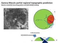
|
-Mike
Posted by: ngunn Dec 18 2008, 10:54 AM
Another excellent post from Emily:
http://www.planetary.org/blog/article/00001775/
I would like to respond to the issue raised in the title - the question of whether Titan is internally active or not. We seem to be offered two possibilities.
1. Inactive.
All the topography is the eroded remains of an ancient cratered surface.
or
2. Active.
Internal heat continues to power crustal tectonic proceses.
As a peripheral observer of events, only having read abstracts and Emily's summaries, I have not heard a whisper about a third possibility, namely:
3. Internally inactive but with ongoing floating-crust tectonism powered externally by the weather.
I have satisfied myself that Titan receives enough energy from the Sun such that only a minute fraction of it is needed to raise Titan's modest hills over geological timescales. We seem to be at a stage in Titan studies where the widest possible set of scenarios are being thrown into the ring. I therefore have two questions. Has anyone heard this third possibility being mentioned at all? And if not, wherein lies the fundamental objection to it?
Posted by: Doc Dec 18 2008, 11:21 AM
An interesting suggestion ngunn. However I find it rather hard to imagine it but no, I myself have never heard of 'atmospherically induced tectonics' being mentioned.
Posted by: Juramike Dec 18 2008, 02:33 PM
That's a pretty interesting suggestion, Nigel!
What sort of observable effects would that create?
If wind-driven tectonic plates are bumping into each other, it might make an effect similar to http://ice-glaces.ec.gc.ca/App/WsvPageDsp.cfm?ID=10992&Lang=eng. Relatively flat plates, but with upraised edges at the edge of the plate margin resulting from continual collisions as the plates bumped around due to the winds. (One prevailing direction of ebb and flow might make the edge height non-uniform around the plate).
I'm not sure we've seen anything like that just yet....
One really general observation about Titan is the ubiquitous E-W trending regularly-spaced tectonic ridges in the equatorial zones. I use them all the time to orient and line up images. Whatever process made these must have been planet wide and uniform on a large scale (and with a N-S strain). This is not what you'd expect with Titan's current orientation (E trending winds at the surface of the equatorial region).
But then there are those broad N-S undulations.....
Posted by: ngunn Dec 18 2008, 03:01 PM
Well, I hesitate to repeat these ideas too often and you have heard it before but in a nutshell it's this. The weather redistibutes mass and destabilises the rotation axis, perhaps gradually, perhaps in a sequence of major 'polar flop' episodes. Readjustment of the ice-shell to its new orientation on the hydrostatic ellipsoid produces the EW tectonic ridges. Note: longitudinal libration can't do this. Surface materials now find themselves at the 'wrong' latitude and are subject either to dessication (a candidate for dune sand formation???) or solution and erosion by liquid (caves systems, sinkholes, caldera-like lake basins???). It's all a flight of fancy of course, but maybe it's a way of having some tectonics and cyclical geological processes on a world with only one 'plate' and limited internal heating.
I like to remember that Titan's atmosphere is huge relative to Titan itself, and even more huge in relation to the mobile ice shell. On this model Callisto is 'Titan without weather' and therefore without the ability to slew it's crust around.
Just an idea.
EDIT: I can't resist linking to this again:
http://www.agu.org/cgi-bin/wais?mm=P31C-04
Posted by: Juramike Dec 18 2008, 03:57 PM
I do like the readjustment idea.
I've wondered about the apparent lower terrain (thus lakes) in the North compared to the South and if it fits in with E-W tectonic ridges. The two elements could be related. (And Xanadu, the "wierd continent" is also sitting on the Equator - is it denser than normal and in it's preferred equatorial placement or just a coincidence of where it happens to be?)
While Titan seems to lack huge cryovolcanic provinces (again, except maybe Xanadu), there seem to be a lot of weird funkyness that hints at a hot interior and active processes:
- the wierd little oval bloop mountains in the sand seas
- hard to explain things like the Evil Eye of Quivira, Coates facula, and friends
- the apparent extruded shape of Sotra Facula and the ghosts of Sotra Facula
- the black smokers of Omacatl Macula and Elpis Macula and the S Senkyo inky (and maybe a N Belet inky?)
- the domes near Menrva (and inside Menrva crater - so it came up post-impact!)
I don't easily see how the features above could have been easily caused by wind or rain. I really favor a hot interior model. Maybe not active tectonics, but definitely more than just and sand and organics moving around.
-Mike
Posted by: marsbug Dec 18 2008, 09:08 PM
I don't easily see how the features above could have been easily caused by wind or rain. I really favor a hot interior model. Maybe not active tectonics, but definitely more than just and sand and organics moving around.
-Mike
Isn't Menrva large enough that any volcanism inside the crater was most likely due to the impact melt beneath the crater bubbling up? How long would the melt from an impact that size stay liquid? If it's a long time compared to local weathering and deposition might the crater be erased and leave an underground lens of liquid which could then erupt to the surface as volcanism? Obviously this didn't happen to Menrva, but titan must be hiding a lot of impact scars, could ancient melt sheets lead us down the garden path with regards to volcanism?
I'm just stream-of-thought-ing here.
Posted by: ngunn Dec 19 2008, 10:05 AM
I can't find a way to doubt that materials do continue to emerge from Titan's subsurface. The atmospheric methane is pretty strong evidence for this. Also there are surface features such as the linear valley in the Huygens images that looks like a classical icy-moon double ridge where presumably some aqueous material has come up from below to fill cracks. Also we have the probability that the liquid water layer itself is heated to some extent by tidal flows in the manner described here: http://www.nature.com/nature/journal/v456/n7223/abs/nature07571.html
So I am not joining the devils advocates' extreme 'Callisto with weather' view. Impacts could result in some temporary volcanism as you descibe, but that should apply equally to Callisto and would mostly be very ancient. I think there is plenty of evidence on Titan for an extra ongoing constructive mechanism at work as well as the destructive ones of weathering and erosion. If it's not an internal heat source it must be an external one, with the powerful weather system acting as the lever to deliver some of that energy downward into the ice shell. I've suggested one way that might work, but I hope others will improve on it.
Posted by: marsbug Dec 19 2008, 11:05 AM
I tend to agree, but the case for cryovolcanoes on titan isn't proven yet! Bear in mind though that even if Titan isn't volcanically active, it's almost certainly seen enough heating and aqueous cryolavas from impacts over it's history to load the crust with astrobiologically interesting materials. The estimates I remember for the life of a water-ammonia melt pool for biggish craters on titan were hundreds to hundreds of thousands of years. I would think something the size of Menrva would fall into the higher end of the spectrum.
On a bit of a tangent, are there any examples on any world we've explored of volcanism driven by impact melts?
Posted by: ngunn Dec 19 2008, 11:10 AM
How anout Mercury?
Posted by: marsbug Dec 19 2008, 01:32 PM
Another world thats still mysterious!
Posted by: stevesliva Dec 19 2008, 03:05 PM
If you google around for the Magellan Radar images of Venusian craters, you'll find some terrific lava flows.
Posted by: belleraphon1 Dec 19 2008, 03:50 PM
[*]hard to explain things like the Evil Eye of Quivira, Coates facula, and friends
[*]the apparent extruded shape of Sotra Facula and the ghosts of Sotra Facula
[*]the black smokers of Omacatl Macula and Elpis Macula and the S Senkyo inky (and maybe a N Belet inky?)
[*]the domes near Menrva (and inside Menrva crater - so it came up post-impact!)
[/list]
All... saw this in a San Francisco Chronicle by David Perlman
http://www.sfgate.com/cgi-bin/article.cgi?f=/c/a/2008/12/17/MNAC14PU10.DTL
Quote from Robert Nelson.....
"The radar evidence pushed the whole concept of cryovolcanism over the top," he said.
They revealed very distinct signs of steep-sided hills topped with craters -"true volcanic morphology," as Nelson put it - rising above large areas of sand dunes made from varied hydrocarbons."
Is this just a reporters misinterpretation of something said or have suggestive looking volcanic cones really been seen in the sand dune areas?
Mike?
Craig
Posted by: Juramike Dec 19 2008, 05:31 PM
Is this just a reporters misinterpretation of something said or have suggestive looking volcanic cones really been seen in the sand dune areas?
Not that I'm aware of, but there is still a lot of recent RADAR data that has not yet been released.
There was an abstract presenting pits in tectonic ridges in the T8 RADAR swath that was possibly related to cryovolcanic activity (more like fumaroles and hotsprings rather than a volcanic crater)
The bloop mountains I was referring to seem very uniform in appearance with a slight mottling to a RADAR-bright signature. (In some of the bloop islands of T8 there are a few ridges that reflect back a bright wrinkle. (No obvious pit central pit)
Some things that might be a interpreted as a breached caldera are in T8 to the WNW of the Huygens landing site, and a feature on Shikoku Facula. The features have a breached opening with what looks like RADAR slightly radar-medium gray dark material spilling out. (RADAR signature similar to that of some of the VIMS dark blue ice sand mantle material). [These could also be impact scars]

|
My favorite candidates for cindercone-looking things are the central part of Coats Facula, a dome that is well outside Menrva in the T3 swath, and a dome that is inside the SW rim of Menrva crater. Based on RADAR look angle, the dome well outside Menrva and the central part of Coats facula both appear to have a rased dias, then a central point (not a crater). (The Coats Facula object is right at the edge of the T28 Swath). 'Course this speculation is assuming that the RADAR reflective materials are constant of roughess and constant material [not a safe assumption!] and that only the slope angle is affecting RADAR return.

|
My absolute favorite extrusive-looking thingy is still Sotra Facula and it's clone stamp buddies arcing to the NE.
There is another Sotra looking thing in Belet, but it resembles more one of the Sotra ghosts.)
-Mike
Posted by: belleraphon1 Dec 19 2008, 07:54 PM
Mike...
Regarding your comments on the "volcanoes" in the sand dunes...
I knew you would be the one to ask. You have an encyclopedic knowledge of the land forms seen in the released data sets.
Thanks
Craig
Posted by: elakdawalla Dec 19 2008, 08:19 PM
There was an area in a radar image that people were pointing to as having flow-like morphology (sort of blobby outlines, with the edges of the blobs having different radar properties from the interiors). I'm not a big fan of interpreting those blobby outlines as being strong evidence of cryovolcanic flows, but in Randy Kirk's presentation there was a topographic image over one of these blobby areas where the topography actually did seem to follow the blobbyness, so at least the radar morphology apparently matches the appearance in a flat RADAR image. I think it might even have been that Region 1 area in the VIMS team's presentation, but I'm not sure.
I do not remember seeing anything that looked like central-pit volcanic mountains among dunes in anybody's presentation. Maybe they put the pictures in one of their papers?
I asked Randy if they plan to release any of the topographic data and he said probably not till next year when it hits the PDS. (I wasn't aware topographic data was going into the PDS at all?)
--Emily
Posted by: belleraphon1 Dec 19 2008, 10:47 PM
Thanks Emily!!!
I am wondering if the reporter might have misinterpreted. But if the quote from Robert Nelson is accurate it certainly is intriguing. Guess I could email David Perlman, the reporter, for clarification, huh.
Craig
Powered by Invision Power Board (http://www.invisionboard.com)
© Invision Power Services (http://www.invisionpower.com)