Chang'e 3 landing and first lunar day of operations, Including landing site geology and localization |

  |
Chang'e 3 landing and first lunar day of operations, Including landing site geology and localization |
 Dec 2 2013, 10:01 AM Dec 2 2013, 10:01 AM
Post
#1
|
|
 Member  Group: Members Posts: 124 Joined: 3-September 12 From: Almeria, SE Spain Member No.: 6632 |
Interesting speculation by the LROC team about a possible landing place near crater Laplace A:
A Great Place to Rove! Chang'E/Yutu could land about 10km south east, then (the rover) cross a wrinkle-ridge and reach the rim of the 8km crater. Thorsten (this is my first name, Denk is the family name) |
 |
 
|
|
Dec 2 2013, 11:58 AM
Post
#2
|
|
 Senior Member Group: Members Posts: 2430 Joined: 30-January 13 From: Penang, Malaysia. Member No.: 6853 |
QUOTE (Thorsten Denk @ Dec 2 2013, 06:01 PM)  Interesting speculation by the LROC team about a possible landing place near crater Laplace A: ...A Great Place to Rove!... Welcome Thorsten  During the Chinese cntv.cn coverage the commentators disused the landing site : the 'Bay of Rainbows'. Sinus Iridum is Latin for "Bay of Rainbows" |
|
|
|
|
Dec 2 2013, 09:09 PM
Post
#3
|
|
|
Member Group: Members Posts: 149 Joined: 18-June 08 Member No.: 4216 |
Looking at the lovely picture of Sinus Iridum a few posts back,
I wonder if the rim of the original crater is supposed to be somewhere under the lava plain and whether the subsurface radar of the rover could pick it up. |
|
|
|
|
Dec 2 2013, 09:29 PM
Post
#4
|
|
|
Solar System Cartographer Group: Members Posts: 10184 Joined: 5-April 05 From: Canada Member No.: 227 |
Yes, it would be under the plains, but probably too deep to be detected. I am more interested in a different possibility - there's a bright/dark boundary between two different mare units, best seen in Clementine data (I posted a false color version higher up the thread). If they land near the boundary and drive over it they may be able to detect the underlying unit beneath the overlying one and get the thickness of the top unit. In fact they may get thichnesses of multiple flow units.
Phil -------------------- ... because the Solar System ain't gonna map itself.
Also to be found posting similar content on https://mastodon.social/@PhilStooke Maps for download (free PD: https://upload.wikimedia.org/wikipedia/comm...Cartography.pdf NOTE: everything created by me which I post on UMSF is considered to be in the public domain (NOT CC, public domain) |
|
|
|
|
Dec 3 2013, 01:18 AM
Post
#5
|
||
|
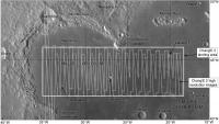
Solar System Cartographer Group: Members Posts: 10184 Joined: 5-April 05 From: Canada Member No.: 227 |
This map shows the extent of the landing region, extending quite far outside Sinus Iridum as well as inside it, and the coverage by Chang'E 2 at about 1.5 m/pixel. When we know where the landing will take place I will be adding more maps to zoom in on the site.
PS - for scale, 5 degrees of latitude is 150 km. Phil
-------------------- ... because the Solar System ain't gonna map itself.
Also to be found posting similar content on https://mastodon.social/@PhilStooke Maps for download (free PD: https://upload.wikimedia.org/wikipedia/comm...Cartography.pdf NOTE: everything created by me which I post on UMSF is considered to be in the public domain (NOT CC, public domain) |
|
|
|
|
|
|
Dec 3 2013, 03:13 AM
Post
#6
|
|
|
Senior Member Group: Members Posts: 2090 Joined: 13-February 10 From: Ontario Member No.: 5221 |
Planning a 'Yutu route map' sticky thread Phil?
 For what it's worth, the LROC team says they'll be photographing the site a few weeks after landing the 25th, January 22nd, and February 18th) http://lroc.sese.asu.edu/news/index.php?/a...;.html#extended |
|
|
|
|
Dec 3 2013, 05:37 AM
Post
#7
|
|
 Senior Member Group: Members Posts: 3419 Joined: 9-February 04 From: Minneapolis, MN, USA Member No.: 15 |
QUOTE (Explorer1 @ Dec 2 2013, 09:13 PM) Planning a 'Yutu route map' sticky thread Phil? You know, that may not be a bad idea. Depending on the volume of images we get from the Chinese, it may be possible to follow the traverse somewhat real-time. I would imagine we will have to wait to see if we get enough imagery to warrant it, but I'm beginning to think that we may need a dedicated Chang'e/Yutu folder, just as each of the Mars rovers has its own folder and LRO has its own folder, etc. I am just on pins and needles waiting to see our first new lunar surface vista in decades! -the other Doug -------------------- The trouble ain't that there is too many fools, but that the lightning ain't distributed right. -Mark Twain
|
|
|
|
|
Dec 3 2013, 05:23 PM
Post
#8
|
|
|
Solar System Cartographer Group: Members Posts: 10184 Joined: 5-April 05 From: Canada Member No.: 227 |
I guess I wasn't subtle enough! Yes, I am planning to map the route - whether in its own thread or not, and that may depend on image access. I am collecting material for a new Moon atlas and this will be part of it.
I will rely very much on our very helpful Chinese contributors for pointing out new articles and other information, translating names of features in the landscape etc. Phil -------------------- ... because the Solar System ain't gonna map itself.
Also to be found posting similar content on https://mastodon.social/@PhilStooke Maps for download (free PD: https://upload.wikimedia.org/wikipedia/comm...Cartography.pdf NOTE: everything created by me which I post on UMSF is considered to be in the public domain (NOT CC, public domain) |
|
|
|
|
Dec 3 2013, 05:32 PM
Post
#9
|
|
 Junior Member Group: Members Posts: 28 Joined: 1-July 13 From: United Kingdom, England Member No.: 6965 |
This will be interesting. I remember seeing a long while ago the High definition video from the probe that went around the moon years ago. Good Stuff.
|
|
|
|
|
Dec 3 2013, 06:01 PM
Post
#10
|
|
|
Senior Member Group: Members Posts: 3419 Joined: 9-February 04 From: Minneapolis, MN, USA Member No.: 15 |
With today's imaging technology, I'm hoping for HD video from the lander of the landing itself, and also of Yutu deployment and operations.
-the other Doug -------------------- The trouble ain't that there is too many fools, but that the lightning ain't distributed right. -Mark Twain
|
|
|
|
|
Dec 3 2013, 07:45 PM
Post
#11
|
|
|
Member Group: Members Posts: 149 Joined: 18-June 08 Member No.: 4216 |
QUOTE (Phil Stooke @ Dec 2 2013, 09:29 PM) Yes, it would be under the plains, but probably too deep to be detected. I am more interested in a different possibility - there's a bright/dark boundary between two different mare units, best seen in Clementine data (I posted a false color version higher up the thread). If they land near the boundary and drive over it they may be able to detect the underlying unit beneath the overlying one and get the thickness of the top unit. In fact they may get thichnesses of multiple flow units. Phil So, Chang'e/Yutu will be landing/roving on top of a geologic sandwich. |
|
|
|
|
Dec 6 2013, 10:51 AM
Post
#12
|
|
|
Junior Member Group: Members Posts: 68 Joined: 15-June 12 From: Hong Kong Member No.: 6419 |
Per latest Chinese reports:
Lunar landing is planned at 15:22-15:35 UTC on December 14. The rover should be deployed from the lander at 20:38-22:21 UTC on the same day. Then some time within the communication window on December 15 at 07:21-15:38 UTC, the lander and rover will photograph each other Source -------------------- UMSF - the place of Opportunity to satisfy your Spirit of Curiosity via Perseverance
|
|
|
|
|
Dec 10 2013, 09:03 PM
Post
#13
|
|
 Member Group: Members Posts: 568 Joined: 20-April 05 From: Silesia Member No.: 299 |
At 9:24 pm, it was confirmed that Change-3 had entered the new orbit.
http://www.asianews.co/change-3-probe-move...er-to-the-moon/ It seems that all is well. -------------------- Free software for planetary science (including Cassini Image Viewer).
http://members.tripod.com/petermasek/marinerall.html |
|
|
|
|
Dec 10 2013, 10:02 PM
Post
#14
|
|
|
Solar System Cartographer Group: Members Posts: 10184 Joined: 5-April 05 From: Canada Member No.: 227 |
Yes, only 15 km high at about 45 degrees north. Not long now.
Phil -------------------- ... because the Solar System ain't gonna map itself.
Also to be found posting similar content on https://mastodon.social/@PhilStooke Maps for download (free PD: https://upload.wikimedia.org/wikipedia/comm...Cartography.pdf NOTE: everything created by me which I post on UMSF is considered to be in the public domain (NOT CC, public domain) |
|
|
|
|
Dec 12 2013, 02:43 PM
Post
#15
|
|
|
Solar System Cartographer Group: Members Posts: 10184 Joined: 5-April 05 From: Canada Member No.: 227 |
Time for a rather trivial prediction. Unless Chang'E 3 lands at the far eastern end of the mapped landing area, the mountain Promontorium Laplace will be visible on the horizon, barring small-scale local obstructions. That will help to give an idea of the location of the landing site quite quickly.
Phil -------------------- ... because the Solar System ain't gonna map itself.
Also to be found posting similar content on https://mastodon.social/@PhilStooke Maps for download (free PD: https://upload.wikimedia.org/wikipedia/comm...Cartography.pdf NOTE: everything created by me which I post on UMSF is considered to be in the public domain (NOT CC, public domain) |
|
|
|
|

|
Lo-Fi Version | Time is now: 5th June 2024 - 06:06 AM |
|
RULES AND GUIDELINES Please read the Forum Rules and Guidelines before posting. IMAGE COPYRIGHT |
OPINIONS AND MODERATION Opinions expressed on UnmannedSpaceflight.com are those of the individual posters and do not necessarily reflect the opinions of UnmannedSpaceflight.com or The Planetary Society. The all-volunteer UnmannedSpaceflight.com moderation team is wholly independent of The Planetary Society. The Planetary Society has no influence over decisions made by the UnmannedSpaceflight.com moderators. |
SUPPORT THE FORUM Unmannedspaceflight.com is funded by the Planetary Society. Please consider supporting our work and many other projects by donating to the Society or becoming a member. |
|