Xanadu, Titan's mysteriously bright continent |

  |
Xanadu, Titan's mysteriously bright continent |
 Dec 6 2008, 11:56 PM Dec 6 2008, 11:56 PM
Post
#1
|
||
 Senior Member  Group: Moderator Posts: 2785 Joined: 10-November 06 From: Pasadena, CA Member No.: 1345 |
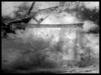
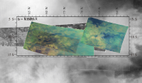
Here is a mosaic of Xanadu that includes:
Some of the higher latitude swaths were skewed slightly by myself to try to better fit the ISS projection. There are mismatches, particularly for the non-equatorial swaths. The resolution is approximately 6 km/pixel. A higher resolution (ca. 1.4 km/pixel) jpeg can be downloaded here (WARNING: 7 Mb file) This will be a handy basemap for Xanadu mosaics and the upcoming RADAR releases. -Mike -------------------- Some higher resolution images available at my photostream: http://www.flickr.com/photos/31678681@N07/
|
|
 |
 
|
|
|
Dec 8 2008, 04:38 AM
Post
#2
|
|||
|
Senior Member Group: Moderator Posts: 2785 Joined: 10-November 06 From: Pasadena, CA Member No.: 1345 |
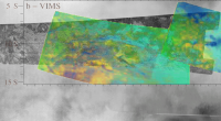
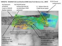
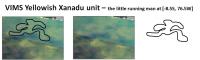
Here is a carefully coordinated blink animation of an enhanced VIMS image of a region in E Xanadu with the corresponding T13 SAR RADAR image overlayed on the T47 ISS Mosaic.
The VIMS image originally appeared in Figure 7 (specifically Figure 7b) from Barnes et al., JGR 112 (2007) E11006. "Near-infrared spectral mapping of Titan's mountains and channels". doi: 10.1029/2007JE002932 and is reproduced here with permission of the author. I increased the hue and saturation of the VIMS sections separately for effect.
(Animated GIF-click to animate) There is a lot of stuff going on in here (indicated in static graphic below):
1) As originally mentioned in the Barnes et al., 2007 article, the VIMS bluer unit correlates to some of the RADAR bright tectonic ridges. (Mabon Macula is the blue peak standing alone near the end of the T13 swath.) 2) From the image above (with the T47 SE Xanadu mosaic as the basemap), one can see that the bluer tectonic ridges form a series of concentric ridges (and valleys) that appear to bend around the entire Hotei Arcus structure located just to the S (the bright section at bottom center is the NE corner of Hotei Arcus) 3) Many (but not all) of the RADAR darker terrains (in this part of Xanadu) appear to correlate to a "yellower" VIMS unit. (From the Barnes et al. 2007 article, most of these terrains are similar to Equatorial bright, but the VIMS spectra are giving information on the "flavor" of the ices - the tectonic ridges are watery-icey flavored Equatorial bright, and the "yellower" VIMS unit is "more organic-icey flavored Equatorial bright.) 4) [a] At the upper corner of the indicated T13 swath, there is a circular form that looks very much like an infilled crater. (Radar bright rim, dark center, possible RADAR-brighter central peak, and at least two breaches in the walls). Unfortunately this area is just outside the VIMS imaged area. [b] However, one of the RADAR-darker flows to the E was imaged by VIMS and correlates to the "yellower" VIMS unit. 5) At the center of the VIMS imaged area, there is a RADAR darker area that appears to embay surrounding terrain. This area correlates to to the "yellower" VIMS unit. 6) The VIMS yellowish - RADAR darkish lobate embayment is not general. There is an arc-like feature (which also extends into the T47 ISS image) that has RADAR-darker sections that are yellow, but others that are VIMS "greenish". Some of the VIMS yellowish area at this feature correlates to the RADAR bright bounding ridges of the arc structure. 7) In general, many of the southern bounding ridges of the embaying valley material appear to be VIMS bluer ridges. (The center of the VIMS image shows an alternating pattern of blue ridges and yellowish valleys) 8) General observation: if the mountain shows RADAR "layover" it correlates to the VIMS bluer unit in this graphic. 9) (The VIMS blue area at the top right of the image that is RADAR dark is part of W Fensal) (I did try to extend to ISS imagery, but I'm not yet confident enough in my coordination of the T47 mosaic images - the T46 images might be a bit easier to deal with. At this point I weakly suspect that the VIMS yellower unit correlates to a slightly brighter terrain in the ISS) -Mike -------------------- Some higher resolution images available at my photostream: http://www.flickr.com/photos/31678681@N07/
|
||
|
|
|
||
|
Dec 8 2008, 10:47 PM
Post
#3
|
|
 Member Group: Members Posts: 131 Joined: 30-August 06 From: Moscow, Idaho Member No.: 1086 |
QUOTE (Juramike @ Dec 7 2008, 10:38 PM)  2) From the image above (with the T47 SE Xanadu mosaic as the basemap), one can see that the bluer tectonic ridges form a series of concentric ridges (and valleys) that appear to bend around the entire Hotei Arcus structure located just to the S (the bright section at bottom center is the NE corner of Hotei Arcus) Very nice work -- if they are concentric with Hotei that will be interesting to compare to what we see down south, - Jason |
|
|
|
|
Dec 12 2008, 12:47 AM
Post
#4
|
|
|
Member Group: Members Posts: 813 Joined: 29-December 05 From: NE Oh, USA Member No.: 627 |
Mike...
Remarkable work, as always. Xanadu fascinates me..... we call it a 'continent', yet we really do not have a proper term for this albedo feature. SAR so far has not seen a lot of positive relief, yet the dunes 'flow' around her as an obstacle. Does not appear as if the Titan "rains" wash her clean of light albedo material which some see as an accumulation of the falling haze particles. The feature is known to be rough. If this is an active area of cryovolcanism, perhaps the "hot spot" (how you get a cryo hot spot in an ice shell disconnected from the silicate interior is another question) keeps the ice soft enough to relax quickly. Yet this feature is not anomalous in heat output. Just fascinating set of unknowns. Mike, keep cataloging your interpretations. P21A-1309 AGU abstract The Dunes of Shangri-La : New Cassini RADAR results on patterns of aeolian features and the influence of topography "Application of monopulse radar methods to retrieve elevations from Cassini SAR images ('SARTopo') now allows us to explore the influence of topography on the local dune (and by implication, wind) patterns, and the relationship between elevation and sediment accumulation. The lack of large positive relief at Xanadu makes its influence on the dunes somewhat surprising." Craig |
|
|
|
|
Dec 12 2008, 01:51 AM
Post
#5
|
|
|
Member Group: Members Posts: 204 Joined: 29-June 05 Member No.: 421 |
Mike -- can you post a version of the VIMS/radar blink comparison with the VIMS image fully opaque? I've found that when you do a blink comparison with one image translucently overlaid over the other, the translucency makes it hard to determine which things really are a synchronicity between the images.
Anyway, awesome work. Thanks! |
|
|
|
|
Dec 12 2008, 03:38 AM
Post
#6
|
||
|
Senior Member Group: Moderator Posts: 2785 Joined: 10-November 06 From: Pasadena, CA Member No.: 1345 |
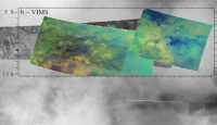
QUOTE (tfisher @ Dec 11 2008, 08:51 PM) Mike -- can you post a version of the VIMS/radar blink comparison with the VIMS image fully opaque? Sure. Here it is (I toned down the saturation to a more reasonable level for a fully opaque image):
(click to animate) Warning: The eye tries to make a "jump" between the RADAR-dark area and the VIMS blue area. But it is the RADAR-bright areas S of the RADAR-dark areas that line up with the VIMS blue areas. (so...Titan's Blue Ridge mountains?) This is why I prefer the translucent image above. Use the mouse cursor to serve as a placemarker on the blinked images. (In fact, when I first read these articles a while ago, my eyes were guilty of making the same jump: doing the overlay exercise really helped me understand the text.) -Mike -------------------- Some higher resolution images available at my photostream: http://www.flickr.com/photos/31678681@N07/
|
|
|
|
|
|
|
Dec 12 2008, 05:58 PM
Post
#7
|
||
|
Member Group: Members Posts: 131 Joined: 30-August 06 From: Moscow, Idaho Member No.: 1086 |
QUOTE (Juramike @ Dec 11 2008, 09:38 PM) Sure. Here it is (I toned down the saturation to a more reasonable level for a fully opaque image):
(click to animate) Warning: The eye tries to make a "jump" between the RADAR-dark area and the VIMS blue area. But it is the RADAR-bright areas S of the RADAR-dark areas that line up with the VIMS blue areas. (so...Titan's Blue Ridge mountains?) This is why I prefer the translucent image above. Use the mouse cursor to serve as a placemarker on the blinked images. (In fact, when I first read these articles a while ago, my eyes were guilty of making the same jump: doing the overlay exercise really helped me understand the text.) -Mike When I was doing the work I used a blink to figure out what was going on. But you can't put a blinking image on paper. Yet  - Jason |
|
|
|
|
|
|
Dec 15 2008, 07:36 PM
Post
#8
|
|
 Member Group: Members Posts: 610 Joined: 23-February 07 From: Occasionally in Columbia, MD Member No.: 1764 |
QUOTE (Juramike @ Dec 11 2008, 10:38 PM) Here it is (I toned down the saturation to a more reasonable level for a fully opaque image): You sure this is lined up right? Does it take the 0.3 pole obliquity into account - seems like moving the VIMS plot a bit north-south makes dark line up with radar-dark rather better.... |
|
|
|
|
Dec 15 2008, 09:20 PM
Post
#9
|
|||
|
Senior Member Group: Moderator Posts: 2785 Joined: 10-November 06 From: Pasadena, CA Member No.: 1345 |
QUOTE (rlorenz @ Dec 15 2008, 02:36 PM) You sure this is lined up right? Yup. Real sure, at least based on the reported lat-lon in the article graphics. I clipped the actual figures from the text (RADAR and VIMS) and made sure the reported lat/lon lines lined up perfectly (less <1 pixel shift N-S based on tick marks). The T13 RADAR portion in the article was slightly lower resolution, so the GIF I made used a higher res version. Here is a blink animation with the article's VIMS (opaque with lat-lon lines), the article's T13 RADAR image, and my T13/T47 SE Xanadu mosaic, with successive removal of the article VIMS graphic , then removal of article RADAR graphic:
(Click to animate) (As an independant check, look at the distinctive RADAR-dark feature centered at [-8.5S,76.5W]. The VIMS yellowish unit has the exact same pattern. In the VIMS it looks like a little yellowish running man with his legs to the S, in the RADAR dark only the RADAR dark legs are easily discerned.)
It was only when I did this precise overlay that I realized the correct correspondence of the units. -Mike [But as I stated before, I'm not sure that the underlying T47 ISS mosaic is correctly coordinated, there may be as much as a 2 degree distortion in my ISS placement]. -------------------- Some higher resolution images available at my photostream: http://www.flickr.com/photos/31678681@N07/
|
||
|
|
|
||
|
Dec 16 2008, 10:05 AM
Post
#10
|
|
|
Member Group: Members Posts: 131 Joined: 30-August 06 From: Moscow, Idaho Member No.: 1086 |
QUOTE (rlorenz @ Dec 15 2008, 01:36 PM) You sure this is lined up right? The pointing errors in SPICE are bad enough that I lined this whole thing up by hand even back before we knew about the pole alignment offset. Furthermore this VIMS cube was taken at a gigantially high phase angle -- something like 120 degrees. So there could be warping through the image, to the effect that it could be perfectly aligned for parts of the image and off in others. Alignment is thought to be correct, but use at your own risk - Jason |
|
|
|
|
Dec 16 2008, 03:49 PM
Post
#11
|
|
|
Senior Member Group: Moderator Posts: 2785 Joined: 10-November 06 From: Pasadena, CA Member No.: 1345 |
Article on Cassini website discussing cryovolcanic activity on Titan:
http://saturn.jpl.nasa.gov/news/press-rele....cfm?newsID=890 And....they released the RADAR image just north of Hotei Arcus! http://photojournal.jpl.nasa.gov/catalog/PIA11702 -------------------- Some higher resolution images available at my photostream: http://www.flickr.com/photos/31678681@N07/
|
|
|
|
|
Dec 16 2008, 08:43 PM
Post
#12
|
||
|
Senior Member Group: Moderator Posts: 2785 Joined: 10-November 06 From: Pasadena, CA Member No.: 1345 |
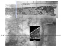
Here's my attempt to locate the recently released RADAR image of Hotei Arcus on the Xandu Mosaic.
(I'll try to to a better job with Photoshop later):
If I got this right, I think the medium gray stuff corresponds to the ISS really bright stuff. The RADAR-dark gray outer ring corresponds to the darker arc outside Hotei Arcus. The RADAR-bright white stuff at the lower portion is completely outside Hotei Arcus, and is not so impressive in ISS (typical "Xanadu stuff"). (Did I get it right?) -Mike -------------------- Some higher resolution images available at my photostream: http://www.flickr.com/photos/31678681@N07/
|
|
|
|
|
|
|
Dec 16 2008, 08:53 PM
Post
#13
|
|
 Senior Member Group: Moderator Posts: 3233 Joined: 11-February 04 From: Tucson, AZ Member No.: 23 |
The Hotei Arcus SAR segment is larger than shown in that graphic.
-------------------- &@^^!% Jim! I'm a geologist, not a physicist!
The Gish Bar Times - A Blog all about Jupiter's Moon Io |
|
|
|
|
Dec 16 2008, 09:01 PM
Post
#14
|
|
|
Senior Member Group: Moderator Posts: 2785 Joined: 10-November 06 From: Pasadena, CA Member No.: 1345 |
QUOTE (volcanopele @ Dec 16 2008, 03:53 PM) The Hotei Arcus SAR segment is larger than shown in that graphic. Has it been released anywhere? -------------------- Some higher resolution images available at my photostream: http://www.flickr.com/photos/31678681@N07/
|
|
|
|
|
Dec 16 2008, 09:13 PM
Post
#15
|
|
|
Senior Member Group: Moderator Posts: 3233 Joined: 11-February 04 From: Tucson, AZ Member No.: 23 |
No, I mean the segment released is larger than you scaled it in the image you just posted. Just a wee bit. Basically, you conclusions are correct though. The margin of Hotei in RADAR SAR corresponds to the bright arc in ISS. The dark arc in RADAR to the south of Hotei corresponds to intermediate albedo terrain on the outside of the bright arc in ISS. The dark material south of Hotei corresponds to mountains in RADAR.
-------------------- &@^^!% Jim! I'm a geologist, not a physicist!
The Gish Bar Times - A Blog all about Jupiter's Moon Io |
|
|
|
|

|
Lo-Fi Version | Time is now: 26th April 2024 - 11:20 AM |
|
RULES AND GUIDELINES Please read the Forum Rules and Guidelines before posting. IMAGE COPYRIGHT |
OPINIONS AND MODERATION Opinions expressed on UnmannedSpaceflight.com are those of the individual posters and do not necessarily reflect the opinions of UnmannedSpaceflight.com or The Planetary Society. The all-volunteer UnmannedSpaceflight.com moderation team is wholly independent of The Planetary Society. The Planetary Society has no influence over decisions made by the UnmannedSpaceflight.com moderators. |
SUPPORT THE FORUM Unmannedspaceflight.com is funded by the Planetary Society. Please consider supporting our work and many other projects by donating to the Society or becoming a member. |
|