South to Vera Rubin Ridge, (Sites 62-63, Sols 1659-1726, Apr 6 2017-Jun 14 2017) |

  |
South to Vera Rubin Ridge, (Sites 62-63, Sols 1659-1726, Apr 6 2017-Jun 14 2017) |
 May 26 2017, 03:18 AM May 26 2017, 03:18 AM
Post
#136
|
||
 Senior Member  Group: Members Posts: 2425 Joined: 30-January 13 From: Penang, Malaysia. Member No.: 6853 |
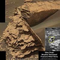
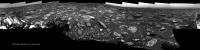
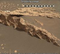
The 1705 R-MastCam mosaic of 'Dike Peak', cropped with added scale bar and a small context inset
|
|
 |
 
|
|
|
May 26 2017, 07:23 AM
Post
#137
|
||
|
Senior Member Group: Members Posts: 2425 Joined: 30-January 13 From: Penang, Malaysia. Member No.: 6853 |
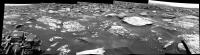
1707 drive, was expected to be ~30 meters, no news yet on actual distance. Here is the L-NavCams mosaic from the available frames
EDIT: Midnight Planets reports the drive as 13.6m S (-177º) Link to 15 frames from the L-NavCam Link using MS ICE (stitching errors) but we look well short of the expected 30 meter in the plan |
|
|
|
|
|
|
May 26 2017, 07:46 PM
Post
#138
|
||
|
Senior Member Group: Members Posts: 2817 Joined: 22-April 05 From: Ridderkerk, Netherlands Member No.: 353 |
The Navcam L view on Sol 1707.
Jan van Driel
|
|
|
|
|
|
|
May 28 2017, 01:54 AM
Post
#139
|
|
|
Senior Member Group: Members Posts: 2425 Joined: 30-January 13 From: Penang, Malaysia. Member No.: 6853 |
|
|
|
|
|
May 30 2017, 09:39 AM
Post
#140
|
||
|
Senior Member Group: Members Posts: 2425 Joined: 30-January 13 From: Penang, Malaysia. Member No.: 6853 |
Short Drive? Sol 1711, partial pan of the L-NavCam's in MS ICE, will add details as they arrive
|
|
|
|
|
|
|
May 30 2017, 03:58 PM
Post
#141
|
|
|
Solar System Cartographer Group: Members Posts: 10145 Joined: 5-April 05 From: Canada Member No.: 227 |
Thanks for that, Paul - using your image and Hazcams, I think we moved roughly 13 m southeast.
Phil -------------------- ... because the Solar System ain't gonna map itself.
Also to be found posting similar content on https://mastodon.social/@PhilStooke NOTE: everything created by me which I post on UMSF is considered to be in the public domain (NOT CC, public domain) |
|
|
|
|
May 31 2017, 06:27 PM
Post
#142
|
||
|
Senior Member Group: Members Posts: 2817 Joined: 22-April 05 From: Ridderkerk, Netherlands Member No.: 353 |
The Navcam L view on Sol 1711.
Jan van Driel
|
|
|
|
|
|
|
May 31 2017, 07:36 PM
Post
#143
|
||
|
Senior Member Group: Members Posts: 2817 Joined: 22-April 05 From: Ridderkerk, Netherlands Member No.: 353 |
and the Navcam L view on Sol 1712.
Jan van Driel
|
|
|
|
|
|
|
Jun 2 2017, 03:45 PM
Post
#144
|
||
 Senior Member Group: Members Posts: 4246 Joined: 17-January 05 Member No.: 152 |
QUOTE (Deimos @ May 24 2017, 06:14 PM)  According to the ephemeris, the shadow of Phobos passed to the south of the rover and over the mound at this time. I don't see anything that is obviously dust activity in the wake of the (very small) thermal effects of the shadow. Now that all the navcams from that 1694 sequence are in here's an animation of all frames showing the penumbra. (The remaining frames show no differences above noise.) I've done a multiplicative rescaling of the overall intensities of the first frames so that the foreground brightnesses match, on the assumption that MSL was outside the penumbra. (It's worth stressing that this isn't proper calibration, just an ad hoc correction for exposure variation.)
We can see the penumbra slip away. The dark highlights on some rocks in the first frame are probably due to specularish reflections of the darkened sky. |
|
|
|
|
|
|
Jun 2 2017, 10:37 PM
Post
#145
|
|||
|
Solar System Cartographer Group: Members Posts: 10145 Joined: 5-April 05 From: Canada Member No.: 227 |
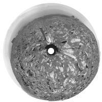
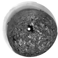
These are circular versions of Jan's panoramas for sols 1711 and 1712.
Phil
-------------------- ... because the Solar System ain't gonna map itself.
Also to be found posting similar content on https://mastodon.social/@PhilStooke NOTE: everything created by me which I post on UMSF is considered to be in the public domain (NOT CC, public domain) |
||
|
|
|
||
|
Jun 3 2017, 12:55 AM
Post
#146
|
||
|
Senior Member Group: Members Posts: 2425 Joined: 30-January 13 From: Penang, Malaysia. Member No.: 6853 |
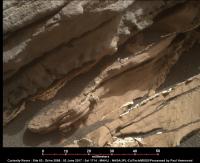
A rather interesting outcrop, erosion features, or some sort of pebbles in the mudstone? Sol 1710 MastCam, added scale bar
|
|
|
|
|
|
|
Jun 3 2017, 04:44 AM
Post
#147
|
|
|
Senior Member Group: Members Posts: 2425 Joined: 30-January 13 From: Penang, Malaysia. Member No.: 6853 |
QUOTE (fredk @ Jun 2 2017, 11:45 PM) We can see the penumbra slip away. The dark highlights on some rocks in the first frame are probably due to specularish reflections of the darkened sky. Great find and perfectly followed up 
|
|
|
|
|
Jun 3 2017, 08:03 AM
Post
#148
|
||
|
Senior Member Group: Members Posts: 2425 Joined: 30-January 13 From: Penang, Malaysia. Member No.: 6853 |
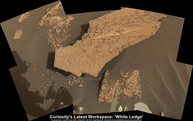
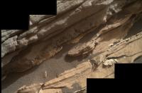
Close-up at "Prays Brook": One image from sol 1714, features what will eventually be a focus merged 'Dogs Eye MAHLI Mosaic' along "Prays Brook" to characterize the contact between the dark gray rocks found in this location and the underlying typical Murray formation. I have added a 50 millimeter scale bar below the mosaic *based on Gerald's 'MAHLI ruler', this should be applied to the 'in-focus' sections only, I plan to assemble the mosaic once the raw frames come down, unless someone beats me to it
|
|
|
|
|
|
|
Jun 3 2017, 03:24 PM
Post
#149
|
|
|
Member Group: Members Posts: 146 Joined: 31-October 08 Member No.: 4473 |
Are those grey rock layers some sort of ash? Or more mudstone? There seems to be an uncomformity with the lower layer.
|
|
|
|
|
Jun 4 2017, 01:08 AM
Post
#150
|
||
|
Senior Member Group: Members Posts: 2425 Joined: 30-January 13 From: Penang, Malaysia. Member No.: 6853 |
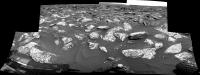
1714: The 'Dog’s Eye MAHLI Mosaic' of "Prays Brook" looks good, but still waiting for the focus merged versions (raw colours, just stitched in MS ICE)
|
|
|
|
|
|
|

|
Lo-Fi Version | Time is now: 18th April 2024 - 10:27 AM |
|
RULES AND GUIDELINES Please read the Forum Rules and Guidelines before posting. IMAGE COPYRIGHT |
OPINIONS AND MODERATION Opinions expressed on UnmannedSpaceflight.com are those of the individual posters and do not necessarily reflect the opinions of UnmannedSpaceflight.com or The Planetary Society. The all-volunteer UnmannedSpaceflight.com moderation team is wholly independent of The Planetary Society. The Planetary Society has no influence over decisions made by the UnmannedSpaceflight.com moderators. |
SUPPORT THE FORUM Unmannedspaceflight.com is funded by the Planetary Society. Please consider supporting our work and many other projects by donating to the Society or becoming a member. |
|