Whole Earth images, Does any satellite provide regularly updated ones? |

  |
Whole Earth images, Does any satellite provide regularly updated ones? |
 Jul 24 2009, 05:24 PM Jul 24 2009, 05:24 PM
Post
#106
|
|
 Senior Member  Group: Members Posts: 2173 Joined: 28-December 04 From: Florida, USA Member No.: 132 |
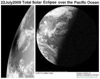
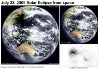
QUOTE (lyford @ Jul 24 2009, 01:15 PM)  I am confused - a geostationary orbit is fixed over a point of the earth - wouldn't that mean that they would only see an eclipse in the hemisphere they can see? The geostationary satellites (plural) do see every eclipse. Not every individual satellite sees every eclipse though. |
 |
 
|
|
Jul 24 2009, 06:16 PM
Post
#107
|
|
 Senior Member Group: Moderator Posts: 2785 Joined: 10-November 06 From: Pasadena, CA Member No.: 1345 |
QUOTE (Hungry4info @ Jul 24 2009, 10:59 AM) I don't know much about this... but shouldn't the geostationary satellites catch a solar eclipse every time? They do but the timing of the publicly available images has to match up to work. GEOS-W images are available every 3 h period, at 0000, 0300, 0600, etc. So for us in the "cheap seats" you need to have the shadow visible in the illuminated field of view at the right time. The satellite over the southern Indian Ocean (I forget the name offhand) only has images available every 6 h time point. The timing didn't match, I couldn't find an image of the shadow over India/SW China. So far I've only found 2 images of the shadow: The GOES W 0300 UTC observation and the METSAT 0300 UTC observation. (+ the NASA processed image of the 0130 observation which is not available to the public as a "raw image"?) Both of these are thus two images of the shadow at the same time and place but from two different viewpoints high above the Earth. -------------------- Some higher resolution images available at my photostream: http://www.flickr.com/photos/31678681@N07/
|
|
|
|
|
Jul 25 2009, 02:56 PM
Post
#108
|
|
 Senior Member Group: Members Posts: 1627 Joined: 5-March 05 From: Boulder, CO Member No.: 184 |
QUOTE (jmknapp @ Jul 24 2009, 01:56 PM) This may be 180° off-topic, but are any photographic (or pseudo-photographic) "whole sky" images available? Showing, say, the visible night sky from Earth on a cylindrical projection? Yes, here's one version (go to FTP link) http://sos.noaa.gov/datasets/solar_system/all-sky.html -------------------- Steve [ my home page and planetary maps page ]
|
|
|
|
|
Jul 26 2009, 12:14 PM
Post
#109
|
|||
 Senior Member Group: Members Posts: 2492 Joined: 15-January 05 From: center Italy Member No.: 150 |
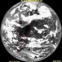
QUOTE (Juramike @ Jul 23 2009, 04:16 PM) Geostationary satellites caught the 22July2009 Eclipse! With some delay, I made a couple of wallpaper compositions with such images, with some denoise in the former and a "difference" image in the latter.
Attached thumbnail(s)
-------------------- I always think before posting! - Marco -
|
||
|
|
|
||
|
Jul 26 2009, 12:44 PM
Post
#110
|
|
 Senior Member Group: Members Posts: 1465 Joined: 9-February 04 From: Columbus OH USA Member No.: 13 |
QUOTE (scalbers @ Jul 25 2009, 10:56 AM) Excellent... wish I had skies dark enough to see that! -------------------- |
|
|
|
|
Jul 26 2009, 06:01 PM
Post
#111
|
|
 Junior Member Group: Members Posts: 87 Joined: 9-November 07 Member No.: 3958 |
QUOTE (jmknapp @ Jul 24 2009, 07:56 AM) This may be 180° off-topic, but are any photographic (or pseudo-photographic) "whole sky" images available? Showing, say, the visible night sky from Earth on a cylindrical projection? The good news is that the PC planetarium program Desktop Universe incorporated a color CCD mosaic covering the whole sky. The bad news is that the company producing it seems to have vanished, and secondary vendors may or may not have copies. (I meant to buy a copy, really I did). It's not too hard to make something usable from a star catalog, perhaps augmented with some fisheye Milky Way pictures. Yeah, I meant to do that background production once too... Edit - I just saw the previous post with an ftp address for Axel Mellinger's wonderful all-sky mosaic. I can't get to it (something about too many redirects). If that's a persistent problem, he has versions on his own site. |
|
|
|
|
Jul 26 2009, 06:52 PM
Post
#112
|
|
|
Senior Member Group: Members Posts: 1627 Joined: 5-March 05 From: Boulder, CO Member No.: 184 |
Yes, here's the FTP link to the cylindrical version I was mentioning:
ftp://public.sos.noaa.gov/astronomy/milky...ll_sky/2048.jpg -------------------- Steve [ my home page and planetary maps page ]
|
|
|
|
|
Jul 26 2009, 09:34 PM
Post
#113
|
|
 Senior Member Group: Members Posts: 1417 Joined: 26-July 08 Member No.: 4270 |
That cylindrical map isn't aligned with the celestial north pole at top v_v. But it is pretty

-------------------- -- Hungry4info (Sirius_Alpha)
|
|
|
|
|
Jul 28 2009, 11:16 AM
Post
#114
|
|
|
Solar System Cartographer Group: Members Posts: 10149 Joined: 5-April 05 From: Canada Member No.: 227 |
-------------------- ... because the Solar System ain't gonna map itself.
Also to be found posting similar content on https://mastodon.social/@PhilStooke NOTE: everything created by me which I post on UMSF is considered to be in the public domain (NOT CC, public domain) |
|
|
|
|
Jul 28 2009, 05:07 PM
Post
#115
|
||
|
Senior Member Group: Members Posts: 2492 Joined: 15-January 05 From: center Italy Member No.: 150 |
QUOTE (Phil Stooke @ Jul 28 2009, 12:16 PM) Chandrayaan saw the eclipse: Cool, a very special viewpoint! I made a rough animation, correcting different zoom of images... slight orientation/aspec ratio differences still visible, however (do someone knows original images without caption?).
Attached thumbnail(s)
-------------------- I always think before posting! - Marco -
|
|
|
|
|
|
|
Aug 5 2009, 06:38 PM
Post
#116
|
|
 Senior Member Group: Members Posts: 3648 Joined: 1-October 05 From: Croatia Member No.: 523 |
Check out the time-lapse footage of the eclipse from the Echostar 11 GEO satellite: http://www.youtube.com/watch?v=TV5y0wFA_GM
-------------------- |
|
|
|
|
Sep 2 2009, 12:30 AM
Post
#117
|
||
|
Senior Member Group: Moderator Posts: 2785 Joined: 10-November 06 From: Pasadena, CA Member No.: 1345 |
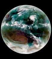
Something I've been working on for a while...combining multichannel IR images of Earth in a meaningful way.
Here is the new and improved pseudocolor Aquavision view of Earth:
IR4 [10.7 um], IR2 [3.9 um], and WV [6.7 um] are all combined using a complex channel mix into the RGB. Here are what colors the correspond to: aqua: water-laden air at mid-latitudes red/brown: dry air white: cold thick cloudtops (cumulonimbus) purple/magenta: cold cirrus clouds (outflow) hazel: warmer suface stratus clouds or fog (IR2 measures lower level surface cloud temps, while IR4 measures upper level ice cloud temps) Hi IR2 emission/Lo IR4 emission = DarkIR2/WhiteIR4 = warm surface terrain /cold ice clouds = cirrus Lo IR2 emission/Hi IR4 emission = White IR2/DarkIR4 = cold surface terrain/ warm high altitudes = stratus or fog. Note how Hurricane Bill causes downwind (in this case to the NE) flow effects like storms on Jupiter. At some point I'm gonna apply this technique to another planet.... -Mike -------------------- Some higher resolution images available at my photostream: http://www.flickr.com/photos/31678681@N07/
|
|
|
|
|
|
|
Dec 20 2009, 09:38 PM
Post
#118
|
|
|
Senior Member Group: Members Posts: 3648 Joined: 1-October 05 From: Croatia Member No.: 523 |
QUOTE (djellison @ May 9 2007, 08:21 AM) While doing that, I also found an Earth-Moon conjunction observation from the Earth 2 flyby that is very Cassini-esque This one has been itching me for years. I've animated all but the ending couple of overexposed frames - in total 54 frames, in color. First, a regular animated GIF (caution, it's over 8 megabytes) can be found here on my Flickr page. Second, an experiment with motion interpolation where I "upsampled" the framerate 5x. The resulting AVI (DivX codec) runs at a smooth 25fps and can be found here. The motion compensator obviously can't cope well with features emerging from the terminator, but overall it doesn't look half bad. If I find a better motion compensator, I might update this. The sequence ended up more difficult than I expected, partly due to significant data dropouts, partly due to noise level. One set had the IR filter miss the scene completely, and another frame had a bad violet filter dropout so they were real salvage jobs. Significant underexposure, Galileo SSI 8-bit A/D converter combined with the fact this is presented gamma-corrected produced ugly background noise that took considerable effort to clean up. Here are two higher quality takeouts, using the overexposed infrared/violet frames at observation start and end, one optimized for the Moon, the other for the Earth: 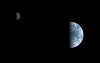 
-------------------- |
|
|
|
|
Dec 20 2009, 11:16 PM
Post
#119
|
|
 Administrator Group: Admin Posts: 5172 Joined: 4-August 05 From: Pasadena, CA, USA, Earth Member No.: 454 |
Oooh awesome awesome awesome, Gordan.
Did I mention AWESOME? Can you explain what causes the "glow" around Earth's limb? This is tremendous. I've looked at that data and I know how gungy it is -- it took a lot of work! Thank you! I enjoy the specular reflection off of the oceans! Does anybody have any brilliant ideas on how to find out what was happening in terms of weather on December 8, 1992? The animation appears to cover the Pacific Ocean, Australia, and Asia, finishing with eastern Africa on the terminator. --Emily -------------------- My website - My Patreon - @elakdawalla on Twitter - Please support unmannedspaceflight.com by donating here.
|
|
|
|
|
Dec 21 2009, 12:05 AM
Post
#120
|
|
|
Senior Member Group: Members Posts: 3648 Joined: 1-October 05 From: Croatia Member No.: 523 |
QUOTE (elakdawalla @ Dec 21 2009, 12:16 AM) Can you explain what causes the "glow" around Earth's limb? First I have to ask if it's the same brightness as in the GIF, because it's supposed to be? If it's not it didn't turn out right and it's a funkiness to the AVI codec instead. It's just the fact that in the end, the SSI is still just a real-world camera with its limitations. The optics are imperfect - diffraction/diffusion internal to the camera cannot be avoided. As I said, this was meant to more accurately convey actual contrast. The usual processing given to images enhances the contrast, suppressing darker areas more and as a result hiding low background noise and such soft diffuse glow around bright objects. Cassini's cameras exhibit this as well (and I'm not talking about that haze problem). My guess is it's the filter as long wavelength infrared filters ehxibit this diffuseness more, on both Cassini and Galileo. P.S. This sequence was taken between 16 Dec 1992 15:40 UTC and 17 Dec 1992 04:50 UTC. At the beginning you can just see the Americas moving off toward the limb. I just realized that makes it 17 years almost to the day since that observation. 17 years, wow... -------------------- |
|
|
|
|

|
Lo-Fi Version | Time is now: 23rd April 2024 - 10:08 AM |
|
RULES AND GUIDELINES Please read the Forum Rules and Guidelines before posting. IMAGE COPYRIGHT |
OPINIONS AND MODERATION Opinions expressed on UnmannedSpaceflight.com are those of the individual posters and do not necessarily reflect the opinions of UnmannedSpaceflight.com or The Planetary Society. The all-volunteer UnmannedSpaceflight.com moderation team is wholly independent of The Planetary Society. The Planetary Society has no influence over decisions made by the UnmannedSpaceflight.com moderators. |
SUPPORT THE FORUM Unmannedspaceflight.com is funded by the Planetary Society. Please consider supporting our work and many other projects by donating to the Society or becoming a member. |
|