Tianwen-1 At Mars |

  |
Tianwen-1 At Mars |
 Feb 14 2021, 04:54 PM Feb 14 2021, 04:54 PM
Post
#16
|
|
|
Member  Group: Members Posts: 204 Joined: 14-April 06 From: Seattle, WA Member No.: 745 |
Planetary Society's Tianwen-1 page has it on Vimeo. Here is the info:
TIANWEN-1 ENTERS MARS ORBIT This video shows China's Tianwen-1 orbiter and rover entering Mars orbit on 10 February 2021. The spacecraft captured the images 3 seconds apart, and the entire video covers a period of 27 minutes. Video: CNSA/PEC via Andrew Jones |
 |
 
|
|
Feb 15 2021, 06:58 PM
Post
#17
|
|
|
Member Group: Members Posts: 103 Joined: 3-February 20 From: Paris (France) Member No.: 8747 |
Hello everybody, Tianwen-1 was now to perform a manoeuvre to move from its equatorial insertion orbit to a polar orbit with the objective of establishing a map of the Martian surface that will be used for the selection of the landing site. https://twitter.com/guo_linli/status/1361114922277425153 TianWen-1 successfully carried out this maneuver  : :https://twitter.com/guo_linli/status/1361277655069327364 |
|
|
|
| Guest_Steve5304_* |
Feb 18 2021, 09:26 PM
Post
#18
|
|
Guests |
QUOTE (Quetzalcoatl @ Feb 15 2021, 07:58 PM)  Hello everybody, Tianwen-1 was now to perform a manoeuvre to move from its equatorial insertion orbit to a polar orbit with the objective of establishing a map of the Martian surface that will be used for the selection of the landing site. https://twitter.com/guo_linli/status/1361114922277425153 TianWen-1 successfully carried out this maneuver :https://twitter.com/guo_linli/status/1361277655069327364 This is really cool. Im so excited to see where China decides to put the lander down |
|
|
|
|
Mar 2 2021, 09:45 AM
Post
#19
|
|
 Member Group: Members Posts: 547 Joined: 1-May 06 From: Scotland (Ecosse, Escocia) Member No.: 759 |
Tianwen-1's orbit has been adjusted further. The South China Morning Post reports that on Wednesday February 24, two weeks after initial orbit insertion, Tianwen-1 entered what they described as "its parking orbit", quoting the space agency CNSA.
"Each complete orbit will take Tianwen, or Heavenly Questions, two Martian days or slightly longer than two days on Earth with the lowest and highest points being 280km (174 miles) and 59,000km above the planets surface. During its time in orbit, Tianwen-1 will use its cameras and spectrometer to carry out a detailed investigation of the Martian landscape and weather at its intended landing site before a planned touchdown in May. Currently the status of equipment is normal and all flight control systems are working as planned, CNSA said. It also acknowledged Perseverance's successful landing at Jezero Crater. South China Morning Post Feb 24 report |
|
|
|
|
Mar 2 2021, 11:09 AM
Post
#20
|
|
 Newbie Group: Members Posts: 15 Joined: 24-July 11 From: Cumberland Plateau Member No.: 6084 |
Will we see orbital pictures from NASA of
the eventual landing or does the ban on cooperation extend to even passive activities such as imaging from orbit? |
|
|
|
|
Mar 2 2021, 12:46 PM
Post
#21
|
|
 Senior Member Group: Members Posts: 1419 Joined: 26-July 08 Member No.: 4270 |
LRO has imaged each of the landed Chang'e missions, so presumably MRO can image the Tianwen-1 lander.
-------------------- -- Hungry4info (Sirius_Alpha)
|
|
|
|
|
Mar 2 2021, 04:08 PM
Post
#22
|
|
|
Senior Member Group: Members Posts: 2511 Joined: 13-September 05 Member No.: 497 |
QUOTE (Hungry4info @ Mar 2 2021, 04:46 AM) LRO has imaged each of the landed Chang'e missions, so presumably MRO can image the Tianwen-1 lander. I don't know if it applied to LROC imaging, but there needed to be congressional approval for at least some LRO support. See https://www.scientificamerican.com/article/...ion-with-china/ -------------------- Disclaimer: This post is based on public information only. Any opinions are my own.
|
|
|
|
|
Mar 4 2021, 02:16 AM
Post
#23
|
|
|
Senior Member Group: Members Posts: 1419 Joined: 26-July 08 Member No.: 4270 |
-------------------- -- Hungry4info (Sirius_Alpha)
|
|
|
|
|
Mar 4 2021, 02:43 AM
Post
#24
|
|
|
Senior Member Group: Members Posts: 2082 Joined: 13-February 10 From: Ontario Member No.: 5221 |
Is the low sun angle why the polar cap isn't bright white like we see in other images (both Hubble and other orbiters?) Or are others "enhanced" and this one is not?
|
|
|
|
|
Mar 4 2021, 05:59 AM
Post
#25
|
|
|
Senior Member Group: Members Posts: 2511 Joined: 13-September 05 Member No.: 497 |
QUOTE (Explorer1 @ Mar 3 2021, 06:43 PM) Is the low sun angle why the polar cap isn't bright white like we see in other images (both Hubble and other orbiters?) Pretty typical for this season. See https://apod.nasa.gov/apod/ap980924.html for example. -------------------- Disclaimer: This post is based on public information only. Any opinions are my own.
|
|
|
|
|
Mar 4 2021, 07:44 AM
Post
#26
|
||
|
Solar System Cartographer Group: Members Posts: 10151 Joined: 5-April 05 From: Canada Member No.: 227 |
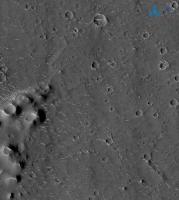
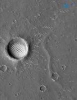
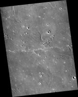
The high resolution image with the small cones on the left edge is at 24.74 N, 110.17 E. I have not found the other location yet. This is right on a candidate site.
CTX image: CTX-J05_046929_2048_XN_24N250W
Phil -------------------- ... because the Solar System ain't gonna map itself.
Also to be found posting similar content on https://mastodon.social/@PhilStooke Maps for download (free PD: https://upload.wikimedia.org/wikipedia/comm...Cartography.pdf NOTE: everything created by me which I post on UMSF is considered to be in the public domain (NOT CC, public domain) |
|
|
|
|
|
|
Mar 4 2021, 08:47 AM
Post
#27
|
|
|
Member Group: Members Posts: 103 Joined: 3-February 20 From: Paris (France) Member No.: 8747 |
QUOTE (SulliedGoon @ Mar 2 2021, 12:09 PM) Will we see orbital pictures from NASA of the eventual landing or does the ban on cooperation extend to even passive activities such as imaging from orbit? Hello, I don't think the ban on cooperation extends also to innocent espionage activities. |
|
|
|
|
Mar 4 2021, 04:16 PM
Post
#28
|
|
|
Senior Member Group: Members Posts: 2511 Joined: 13-September 05 Member No.: 497 |
QUOTE (Quetzalcoatl @ Mar 4 2021, 12:47 AM) I don't think the ban on cooperation extends also to innocent espionage activities. Not sure what point you're trying to make. To image during the landing, the MRO team would have to know the time and place weeks or months in advance, adjust the spacecraft's orbit, and plan the images. If CNSA doesn't make that information public on that timescale, it's not happening. Post-landing imaging might be easier if there was some information about where to look. -------------------- Disclaimer: This post is based on public information only. Any opinions are my own.
|
|
|
|
|
Mar 4 2021, 05:04 PM
Post
#29
|
|
 Senior Member Group: Members Posts: 2530 Joined: 20-April 05 Member No.: 321 |
QUOTE (Explorer1 @ Mar 3 2021, 07:43 PM) Is the low sun angle why the polar cap isn't bright white To add a bit more detail, during a long winter night, a martian polar cap accumulates CO2 ice. Meanwhile, the other hemisphere is in summer, and warm and kicking up dust clouds. As atmospheric dust settles, it creates a thin layer of dust over the otherwise white polar ice of the winter cap. Southern summer is now over and we're seeing the northern cap for the first time in months. Next, the "spider" phenomenon will begin wherein sublimating CO2 ice will pop small holes in the dusty cover. Eventually, the CO2 will be gone and there'll be a dirty H2O ice cap at minimum size. And when that goes through martian autumn, new CO2 ice (and H2O frost) will make the cap grow big and white. |
|
|
|
|
Mar 15 2021, 06:04 PM
Post
#30
|
|
|
Member Group: Members Posts: 103 Joined: 3-February 20 From: Paris (France) Member No.: 8747 |
QUOTE (mcaplinger @ Mar 4 2021, 05:16 PM) Not sure what point you're trying to make. To image during the landing, the MRO team would have to know the time and place weeks or months in advance, adjust the spacecraft's orbit, and plan the images. If CNSA doesn't make that information public on that timescale, it's not happening. Post-landing imaging might be easier if there was some information about where to look. Of course.  I have never said that we could see such images but simply that a cooperation ban is completely foreign to that. |
|
|
|
|

|
Lo-Fi Version | Time is now: 25th April 2024 - 04:06 AM |
|
RULES AND GUIDELINES Please read the Forum Rules and Guidelines before posting. IMAGE COPYRIGHT |
OPINIONS AND MODERATION Opinions expressed on UnmannedSpaceflight.com are those of the individual posters and do not necessarily reflect the opinions of UnmannedSpaceflight.com or The Planetary Society. The all-volunteer UnmannedSpaceflight.com moderation team is wholly independent of The Planetary Society. The Planetary Society has no influence over decisions made by the UnmannedSpaceflight.com moderators. |
SUPPORT THE FORUM Unmannedspaceflight.com is funded by the Planetary Society. Please consider supporting our work and many other projects by donating to the Society or becoming a member. |
|