Printable Version of Topic
Click here to view this topic in its original format
Unmanned Spaceflight.com _ Uranus and Neptune _ Voyager at Neptune: 20 years later...
Posted by: Ian R Aug 14 2009, 09:11 AM
For the 20th anniversary of the Neptune encounter, I've uploaded the official JPL animation of the flyby to YouTube:
http://www.youtube.com/watch?v=PdBOZWB3iAI
I have very fond memories of watching this clip over and over again as a rather eager 9-year old!
Ian.
Posted by: dmuller Aug 14 2009, 12:41 PM
Mmm I love this stuff.
I have written a very quick page that uses the solar system simulator to show what Voyager 2 was seeing exactly 20 years ago:
http://www.dmuller.net/realtime/imagesv2nep.php
and don't forget, the 30th anniversary of the Pioneer 11 flyby at Saturn is coming up soon as well:
http://www.dmuller.net/realtime/p11saturn.php?mission=pioneer11h
Posted by: tedstryk Aug 14 2009, 02:04 PM
Cool, but I am surprised you left out the Titan encounter.
Posted by: dmuller Aug 14 2009, 03:07 PM

Patience ... the timeline scrolls through the events, and only shows the next 15 events. Titan closest approach (not close at all actually) happened on the way out. Full, static timeline at
http://www.dmuller.net/realtime/mission.php?mission=pioneer11&appear=black
Posted by: tedstryk Aug 14 2009, 04:48 PM
http://www.dmuller.net/realtime/mission.php?mission=pioneer11&appear=black
Since it showed the end of mission date, I didn't think there was more.
Posted by: DrShank Aug 23 2009, 05:19 PM
check out my blogs on
http://beyondthecradle.wordpress.com/ about the Voyager anniversary at Neptune.
also I am preparing an updated Triton flyover movie and some stills from it for release on Tuesday
to help celebrate the milestone. some of these can also be seen at http:/stereomoons.blogspot.com
i will also be posting some new Miranda views as well as a hot tidbit from Enceladus this week . . .
cheers
paul
|
Posted by: DrShank Aug 25 2009, 02:16 PM
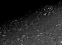
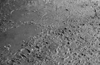
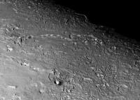
As promised, here are stills from the new Triton movie. It is a difficult subject to work with, given that topography rarely exceeds half a kilometer. Triton isnt given to the method school of acting I guess. Hence you will not see towering volcanoes and such. Note that it is iPod format!
To see the movie, go to my stereomoons.blogspot.com site. It currently exceeds the 1mb upload limit, although i will see if I can shrink it. NASA Photojournal is also scheduled to post it later today at full resolution.
Paul

|
|
|
Posted by: 4th rock from the sun Aug 25 2009, 03:09 PM
Most impressive ! Is the altimetry data going to be released in some map format ? I'm thinking that it might be possible to get it into Orbiter Space Flight Simulator for example or at least into Celestia.
Posted by: DrShank Aug 25 2009, 05:11 PM
given that the stereo on Triton is very weak (and corrupted), this is shape-from-shading. I can release some of the data but it would require an explanation of its weaknesses, which are mostly in subtle long distance warping. The Ariel and Miranda data are in much better shape.
cheers
paul
Posted by: tedstryk Aug 26 2009, 12:52 AM
Another problem with Triton is that it's topography is much more subdued than Ariel or Miranda.
Posted by: 4th rock from the sun Aug 26 2009, 09:24 AM
For a simple free simulation such as Orbiter, there's no need for great acuracy. There's already a plugin for generating terrain from real or fractal functions. It's great because you can simulate a landing using realistic spacecraft parameters, velocities, mass, atmospheric pressure (if there's an atmosphere present), etc.
Here's more info and screenshots: http://www.orbiterwiki.org/wiki/Orulex
Please remenber that's it's a acurate simulation based on real world phisics and not an arcade starwars like game, so the visuals are not stunning. Nevertheless it runs very well on an average PC and in realtime.
At this time, only SRTM global Earth terrain , Clementine global Moon terrain and MOLA global Mars terrain are avaliable from servers. But it's possible to generate terrain from any grayscale image (less accurate but easier to do). That was what I was thinking about, a simple grayscale jpg with altimeter values on simple cylindrical projection would be very nice :-) ! Of course, there's already color mapped altimetry here:http://www.isprs.org/congresses/beijing2008/proceedings/4_pdf/172.pdf but extracting them from the PDF would destroy any accuracy.
Posted by: tedstryk Aug 26 2009, 04:09 PM
I have made some Voyager-Neptune at 20 related posts in my long-defunct blog.
http://planetimages.blogspot.com/
Posted by: PhilCo126 Sep 2 2009, 12:29 PM
Impressive Voyager 2 images and, except for the 1990 Voyager 1 mosaic of the planets, a superb farewell of the Voyager mission to the solar system. Most interesting follow-on was the fact that a JPL-member (Brad Smith I believe) had to be part of the IAU council in the time-consuming job of giving names to the new features on Triton. Real official names, not the JPL names such as "the scooter", for a white cloud around Neptune's South pole ... 
Powered by Invision Power Board (http://www.invisionboard.com)
© Invision Power Services (http://www.invisionpower.com)