MSL Route Map |

  |
MSL Route Map |
 Dec 5 2012, 09:55 PM Dec 5 2012, 09:55 PM
Post
#91
|
|
|
Member  Group: Members Posts: 148 Joined: 9-August 11 From: Mason, TX Member No.: 6108 |
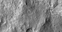
In the JPL Photojournal gallery I finally paid attention to this 3D image of the Glenelg site--worth viewing side by side with the current route map to appreciate the remarkable elevations (albeit enhanced in this view) that Curiousity is traversing:
http://photojournal.jpl.nasa.gov/catalog/PIA16210 (context page for the image versions) -------------------- --
Don |
 |
 
|
|
Dec 6 2012, 12:48 AM
Post
#92
|
|
|
Member Group: Members Posts: 252 Joined: 5-May 05 From: Mississippi (USA) Member No.: 379 |
QUOTE (MarsInMyLifetime @ Dec 5 2012, 05:55 PM)  In the JPL Photojournal gallery I finally paid attention to this 3D image of the Glenelg site--worth viewing side by side with the current route map Thanks for the link. I have an anaglyph graphic of the same area, but at a lesser (and unknown) 3d exaggeration. The labeled 10X exaggeration should be a big help for orientation purposes. |
|
|
|
|
Dec 7 2012, 05:15 PM
Post
#93
|
||
|
Solar System Cartographer Group: Members Posts: 10146 Joined: 5-April 05 From: Canada Member No.: 227 |
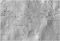
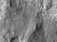
Update for sol 120 - a good location but only an assumed straight line route right now. That may be updated. This also includes some new names from the recently released map. Note that I am choosing to use 'Glenelg' for a region, not a specific point, but I may revise that later.
Phil
-------------------- ... because the Solar System ain't gonna map itself.
Also to be found posting similar content on https://mastodon.social/@PhilStooke NOTE: everything created by me which I post on UMSF is considered to be in the public domain (NOT CC, public domain) |
|
|
|
|
|
|
Dec 10 2012, 02:44 PM
Post
#94
|
||
|
Solar System Cartographer Group: Members Posts: 10146 Joined: 5-April 05 From: Canada Member No.: 227 |
Updated route map. I have corrected the first guess of the 121 position I made in another thread (and added a note there). The 120-121 route is only a guess in the absence of rear-looking images.
Phil
-------------------- ... because the Solar System ain't gonna map itself.
Also to be found posting similar content on https://mastodon.social/@PhilStooke NOTE: everything created by me which I post on UMSF is considered to be in the public domain (NOT CC, public domain) |
|
|
|
|
|
|
Dec 10 2012, 02:59 PM
Post
#95
|
||
|
Solar System Cartographer Group: Members Posts: 10146 Joined: 5-April 05 From: Canada Member No.: 227 |
This is a different version of the map with a scaled grid. I will post it from time to time along the way.
Phil
-------------------- ... because the Solar System ain't gonna map itself.
Also to be found posting similar content on https://mastodon.social/@PhilStooke NOTE: everything created by me which I post on UMSF is considered to be in the public domain (NOT CC, public domain) |
|
|
|
|
|
|
Dec 10 2012, 05:51 PM
Post
#96
|
||
|
Solar System Cartographer Group: Members Posts: 10146 Joined: 5-April 05 From: Canada Member No.: 227 |
And another update:
sol 123, descending towards the Bay. Phil
-------------------- ... because the Solar System ain't gonna map itself.
Also to be found posting similar content on https://mastodon.social/@PhilStooke NOTE: everything created by me which I post on UMSF is considered to be in the public domain (NOT CC, public domain) |
|
|
|
|
|
|
Dec 11 2012, 05:56 PM
Post
#97
|
||
|
Solar System Cartographer Group: Members Posts: 10146 Joined: 5-April 05 From: Canada Member No.: 227 |
Sol 124 update.
Phil
-------------------- ... because the Solar System ain't gonna map itself.
Also to be found posting similar content on https://mastodon.social/@PhilStooke NOTE: everything created by me which I post on UMSF is considered to be in the public domain (NOT CC, public domain) |
|
|
|
|
|
|
Dec 12 2012, 05:52 PM
Post
#98
|
||
|
Solar System Cartographer Group: Members Posts: 10146 Joined: 5-April 05 From: Canada Member No.: 227 |
And... sol 125 update. The route from 124 to 125 is only a guess so far.
Phil
-------------------- ... because the Solar System ain't gonna map itself.
Also to be found posting similar content on https://mastodon.social/@PhilStooke NOTE: everything created by me which I post on UMSF is considered to be in the public domain (NOT CC, public domain) |
|
|
|
|
|
|
Dec 13 2012, 12:59 AM
Post
#99
|
|
 Member Group: Members Posts: 754 Joined: 9-February 07 Member No.: 1700 |
hmm, left turn mid-drive - avoiding or pursuing?
|
|
|
|
|
Dec 13 2012, 01:24 AM
Post
#100
|
|
 Administrator Group: Admin Posts: 5172 Joined: 4-August 05 From: Pasadena, CA, USA, Earth Member No.: 454 |
Just taking advantage of a natural ramp to drop down a low ledge.
-------------------- My website - My Patreon - @elakdawalla on Twitter - Please support unmannedspaceflight.com by donating here.
|
|
|
|
|
Dec 14 2012, 09:42 PM
Post
#101
|
|
 Senior Member Group: Members Posts: 1465 Joined: 9-February 04 From: Columbus OH USA Member No.: 13 |
I updated the rover track map on http://curiositymsl.com to use OpenLayers mapping javascript code, allowing you to zoom/pan and such. As before, the rover position is based on the unofficial NAIF data which is updated roughly every day.
MSL track map -------------------- |
|
|
|
|
Dec 17 2012, 04:06 PM
Post
#102
|
||
|
Solar System Cartographer Group: Members Posts: 10146 Joined: 5-April 05 From: Canada Member No.: 227 |
Here's the map with the sol 127 move added. As always, adjustments to earlier positions or route segments may be added as well.
For the sol 127 position, I have mapped it using a circular half-pan at this location (a bit bigger than the recently posted version by Ant103) and there's no doubt in my mind that the position I show here is better than the one at the end of the map linked in the previous post. I love jmknapp's new things, but something's slightly off. His background image is an orthophoto, supposedly corrected by using a DEM to remove distortions. Mine is not (because the reprojection loses fine detail). So my positions are as close as I can get them to the true position relative to surface features, but those features are displaced a bit by slightly oblique viewing of relief. Therefore, so are my positions, they are not in the exact x,y location but they are adjacent to the correct features. If you overlay jmknapp's map and mine you can see the distortion caused by relief. So why are the x,y postions in the new map not in quite the right places relative to the background image? I suspect it's partly a matter of registration of the two datasets, and partly that the DEM is not perfect and so leaves residual distortions in the orthophoto. Mapping is more complicated than it appears at first. Phil
-------------------- ... because the Solar System ain't gonna map itself.
Also to be found posting similar content on https://mastodon.social/@PhilStooke NOTE: everything created by me which I post on UMSF is considered to be in the public domain (NOT CC, public domain) |
|
|
|
|
|
|
Dec 17 2012, 05:37 PM
Post
#103
|
|
|
Member Group: Admin Posts: 976 Joined: 29-September 06 From: Pasadena, CA - USA Member No.: 1200 |
QUOTE (Phil Stooke @ Dec 17 2012, 08:06 AM) ... So why are the x,y postions in the new map not in quite the right places relative to the background image? I suspect it's partly a matter of registration of the two datasets, and partly that the DEM is not perfect and so leaves residual distortions in the orthophoto. Mapping is more complicated than it appears at first. Phil Phil that might be true. We are close to the very (Eastern) edge of the DEM here. You could try to see if the ESP_023957_1755 DEM works better. Paolo -------------------- Disclaimer: all opinions, ideas and information included here are my own,and should not be intended to represent opinion or policy of my employer.
|
|
|
|
|
Dec 18 2012, 01:13 AM
Post
#104
|
|
|
Senior Member Group: Members Posts: 1465 Joined: 9-February 04 From: Columbus OH USA Member No.: 13 |
No doubt your triangulations from the circular pans etc. are more accurate for fixing the position on the map. I'm just taking the MSL_TOPO coordinates from SPICE at face value and admit to registering the SPICE-generated track (slight translation and rotation) to the DEM HiRISE photo so it more or less matched NASA's map and your map. Hopefully things will be pretty linear from there, and the spherical distortions near the equator won't be too bad. I am under no illusion that mapping is easy! I gather that generating a DEM from a HiRISE stereo pair is a very labor-intensive process, prone to artifacts if not done right, which is why there aren't a whole lot of them.
-------------------- |
|
|
|
|
Dec 18 2012, 01:38 AM
Post
#105
|
|
|
Solar System Cartographer Group: Members Posts: 10146 Joined: 5-April 05 From: Canada Member No.: 227 |
I am actually delighted to see the different approaches that are being used here. My method often will not show me wiggles along the route, if tracks are not imaged, but your data help show where they are.
Phil -------------------- ... because the Solar System ain't gonna map itself.
Also to be found posting similar content on https://mastodon.social/@PhilStooke NOTE: everything created by me which I post on UMSF is considered to be in the public domain (NOT CC, public domain) |
|
|
|
|

|
Lo-Fi Version | Time is now: 19th April 2024 - 11:00 PM |
|
RULES AND GUIDELINES Please read the Forum Rules and Guidelines before posting. IMAGE COPYRIGHT |
OPINIONS AND MODERATION Opinions expressed on UnmannedSpaceflight.com are those of the individual posters and do not necessarily reflect the opinions of UnmannedSpaceflight.com or The Planetary Society. The all-volunteer UnmannedSpaceflight.com moderation team is wholly independent of The Planetary Society. The Planetary Society has no influence over decisions made by the UnmannedSpaceflight.com moderators. |
SUPPORT THE FORUM Unmannedspaceflight.com is funded by the Planetary Society. Please consider supporting our work and many other projects by donating to the Society or becoming a member. |
|