Printable Version of Topic
Click here to view this topic in its original format
Unmanned Spaceflight.com _ Dawn _ Ceres Low-Altitude Mapping Orbit (LAMO)
Posted by: Bill Harris Dec 22 2015, 04:50 PM
Hit http://photojournal.jpl.nasa.gov/keywords/dp .
The first LAMOs are here.
--Bill
Posted by: craigmcg Dec 22 2015, 09:03 PM
LAMOs are going to be good.
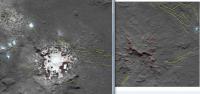
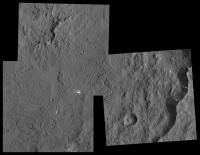
Posted by: Gladstoner Dec 22 2015, 09:11 PM
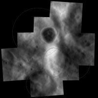
Holy image compression Batman:
http://photojournal.jpl.nasa.gov/catalog/PIA20185
Posted by: Bill Harris Dec 23 2015, 01:07 AM
Something went very wrong there-- my first impression was "need to deinterlace" but it's too blocky for that.
I'm having a time figuring out what is where on these wrt the HAMOs. The shots are oblique and I'm not accustomed to the scale. I'll be better once I find the epiphany of a landmark or two.
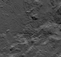
The Azacca Crater (??) / Samhain Catena area of the LAMO images pia20184 pia20185 and pia20186 may be covered by HAMO images HO-9, 27, 42, 45 and Survey Orbit images SO-11, 48.
--Bill
Posted by: JohnVV Dec 23 2015, 01:17 AM
no kidding !!! -- a zoom of the tiff
http://imgbox.com/MKNh375p
or
|
Posted by: nprev Dec 24 2015, 11:13 PM
Looks like we're there now! http://dawn.jpl.nasa.gov/news/news-detail.html?id=4802. Probably gonna be a bit slow for a couple of days due to US holidays, but please post all relevant discussion here; thanks!
Posted by: craigmcg Jan 12 2016, 02:04 PM
... very slow :-)
Posted by: ZLD Jan 12 2016, 03:24 PM
Funny that you chose today to post to this thread.
https://www.nasa.gov/feature/jpl/new-details-on-ceres-seen-in-dawn-images/
|
Four, including the one posted have been added to the photojournal:
http://photojournal.jpl.nasa.gov/catalog/PIA20191
http://photojournal.jpl.nasa.gov/catalog/PIA20192
http://photojournal.jpl.nasa.gov/catalog/PIA20193
http://photojournal.jpl.nasa.gov/catalog/PIA20194
Posted by: charborob Jan 12 2016, 04:19 PM
Spectacular! Unfortunately, the TIFF files on the Photojournal are identical to the JPEG files, that is, they are affected by JPEG artifacts. I wonder why they bother to post the TIFF images. There should be much more detail in the uncompressed images, whenever they become available.
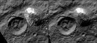
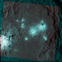
Posted by: GS_Brazil Jan 12 2016, 05:00 PM
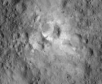
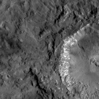
Looking at the white spot, I see it's made of several smaller white spots, just like in the Occator crater.
http://photojournal.jpl.nasa.gov/jpegMod/PIA20193_modest.jpg
Posted by: craigmcg Jan 12 2016, 10:08 PM

Maybe I reminded the powers that be...


Posted by: antipode Jan 13 2016, 04:25 AM
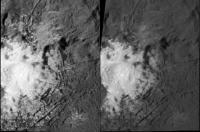
Look at the floor of Dantu!
http://photojournal.jpl.nasa.gov/jpegMod/PIA20193_modest.jpg
wowowowow. Impact melt craziness? And the obligatory white patch.
P
Edit: actually reminds me a bit of the 'spider' at the center of Caloris on mercury. Different materials of course but...
Posted by: ZLD Jan 13 2016, 08:27 AM
Since they haven't started designating LAMO images with numbers, I'm lettering them until they do.
http://photojournal.jpl.nasa.gov/catalog/PIA20191
http://i.imgur.com/Y6zQeAk.png
http://photojournal.jpl.nasa.gov/catalog/PIA20192
http://i.imgur.com/7GSJ6gA.png
http://photojournal.jpl.nasa.gov/catalog/PIA20193
http://i.imgur.com/rgW5pmG.png
http://photojournal.jpl.nasa.gov/catalog/PIA20194
http://i.imgur.com/4umlZfs.png
http://i.imgur.com/sa0zQ3y.jpg
Posted by: ZLD Jan 13 2016, 06:19 PM
http://photojournal.jpl.nasa.gov/catalog/PIA20195
http://i.imgur.com/y19luZq.png
http://i.imgur.com/XHJv5OL.jpg
Posted by: ZLD Jan 15 2016, 07:24 AM
http://photojournal.jpl.nasa.gov/catalog/PIA20296
http://i.imgur.com/dvuBn3r.png
http://i.imgur.com/y3vWKnA.jpg
Posted by: ZLD Jan 15 2016, 07:37 PM
http://photojournal.jpl.nasa.gov/catalog/PIA20297
http://zldoyle.blogspot.com/2016/01/lamo-7.html
http://i.imgur.com/2ojXRXY.png
http://i.imgur.com/y3vWKnA.jpg
Posted by: JohnVV Jan 17 2016, 06:06 AM
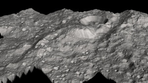
a few low angle views from LAMO-6
PIA20296
http://imgbox.com/dlq1ziab http://imgbox.com/7HOSwTwk http://imgbox.com/YuSYTSN6 http://imgbox.com/VK9M0dnE
Posted by: JohnVV Jan 20 2016, 04:00 AM
some more renderings
This time "Kupalo Crater"
http://dawn.jpl.nasa.gov/multimedia/images/image-detail.html?id=PIA20192
http://imgbox.com/DBfCzFFI http://imgbox.com/snu1qLHv http://imgbox.com/w2UvSNaE http://imgbox.com/IZZc2lI8
Posted by: ZLD Jan 20 2016, 04:42 AM
http://photojournal.jpl.nasa.gov/catalog/PIA20298
http://zldoyle.blogspot.com/2016/01/lamo-8.html
http://i.imgur.com/fp8tuL4.png
http://i.imgur.com/6ATFjCm.jpg
Posted by: ZLD Jan 21 2016, 04:22 PM
http://photojournal.jpl.nasa.gov/catalog/PIA20299
http://zldoyle.blogspot.com/2016/01/lamo-9.html
http://i.imgur.com/ie39PPU.png
http://i.imgur.com/tjcJPzN.jpg
Posted by: ZLD Jan 24 2016, 12:14 AM
http://zldoyle.blogspot.com/2016/01/lamo-10-lamo-11.html
http://photojournal.jpl.nasa.gov/catalog/PIA20300
http://i.imgur.com/628snkq.png
http://photojournal.jpl.nasa.gov/catalog/PIA20301
http://i.imgur.com/AUejdTj.png
http://i.imgur.com/WXMXLzI.jpg
Posted by: ZLD Jan 25 2016, 08:17 PM
http://zldoyle.blogspot.com/2016/01/lamo-12.html
http://photojournal.jpl.nasa.gov/catalog/PIA20302
http://i.imgur.com/ferU39i.png
http://i.imgur.com/9VHfHQq.jpg
Posted by: ZLD Jan 26 2016, 08:17 PM
http://zldoyle.blogspot.com/2016/01/lamo-13.html
http://photojournal.jpl.nasa.gov/catalog/PIA20303
http://i.imgur.com/cPCbxR2.png
http://i.imgur.com/3cWyuEG.jpg
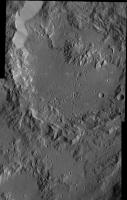
Posted by: Gladstoner Jan 26 2016, 08:46 PM
Fascinating features.
So what's with those radiating 'bird feet'? If I saw those hills on Earth, I'd think they were an erosional remnant of a larger mountain. But on Ceres, there is no apparent process to remove the material in such a manner.
Posted by: ZLD Jan 26 2016, 09:52 PM
My best guess is that right after impact, the basin uplifted into something resembling the central ridge you see, and as it rapidly cooled, the exterior sort-of buckled inwards as it compressed from cooling unevenly. This would only be possible if this region is heavier in rocky material.
I will say, I am especially intrigued by the feature at center left, along the central ridge. Tall peak, central pit, who knows...
Posted by: Ken2 Jan 26 2016, 11:21 PM
So what's with those radiating 'bird feet'? If I saw those hills on Earth, I'd think they were an erosional remnant of a larger mountain. But on Ceres, there is no apparent process to remove the material in such a manner.
I favor the least interesting explanation as evident in LAMO G, I think it's due to settling and sliding of the puffy ejecta in-fill of the craters.
Most craters* start out as an empty cones, and in-fill by their ejecta and landslides, and the ejecta of countless other craters. The craters are filled of unstable relatively puffy fine-grained ejecta. Subsequent impacts cause huge Ceres-quakes which will cause landslides (clearly evident all over the place) and settling, which I believe is the majority of the cracks on crater floors.
*Most craters (other then young ones big enough to have lava in-fill at the time of creation, and very large ones (I don't know what that size is on Ceres, and it's probably a function of age))
e.g. old (earliest) craters have a harder surface which may rebound more. Also assuming it was mostly a molten interior at the time of formation, then the lava in-fill (and after a given crater could no longer expose lava) then elastic rebound would be decreasing as a function of age. The later craters would be formed in a puffy impact gardened surface which looks to be km thick. An impact in a loosely bound matrix would evacuate a clean cone and then have severe landslides back into the pit. It's even possible that most of the central peaks are in fact landslide conjunctions (i.e. if there are landslides all around the craters they would meet in the middle and after a few met the forming ridge/peak would accumulate subsequence landslide terminating debris as the crater in-filled. I think these type of processes may explain the majority of Cere's crater's features. I wonder what magnitude Cere's quake is generated for a given impact diameter and distance from the impact?
Posted by: JohnVV Jan 27 2016, 12:37 AM
impact , stresses, land movement and so on
i bet that when the papers start coming out it will be many things all having a part
No 3d renderings yet , just a heightmap
-- 8 bit normalized 0,255
http://imgbox.com/AIERtUXd
Posted by: Gladstoner Jan 27 2016, 02:19 AM
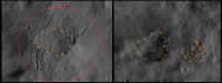
Occator and Dantu: Before and after?
|
Possibly analogous features marked:
|
Can't wait to see the Occator close-ups....
Posted by: Bill Harris Jan 27 2016, 03:21 AM
The Asterisk Central peaks are likely volcanic.
--Bill
Posted by: ZLD Jan 27 2016, 09:29 AM
I'd like them to be volcanic as well but there's little to show they are. No visible flows anywhere really. Not that they couldn't have long since been erased, but there's no evidence to push for it. Several mound-like features are present with what would seem to be central depressions.
Also, interesting comparison Gladstoner. I definitely think there is some resemblance here. However, I have to wonder that if they have been through similar processes, in regards to Dantu, why has a small patch of bright material near the cracks remained while everything else has disappeared, especially a bright central patch of it in the center of the central ridge. One possibility is that it has been recently active, long after most of the bight material was covered up or insolation caused the material to become less reflective. But if it was recently active, then how? Strange place.
Posted by: Habukaz Jan 27 2016, 01:21 PM
https://twitter.com/NASA_Dawn/status/692099462332682241
Haven't seen or heard any word on the mountain, yet.
Posted by: Bill Harris Jan 27 2016, 03:26 PM
My idea is that the really good LAMO images are spectacular and good material for papers, so they've not released them in the dozen-or-so daily images. After the papers get out and the data hits the PDS we'll have some jaw-droppers. Time will tell.
--Bill
Posted by: ZLD Jan 27 2016, 05:12 PM
http://zldoyle.blogspot.com/2016/01/lamo-14.html
http://photojournal.jpl.nasa.gov/catalog/PIA20304
http://i.imgur.com/3WLDPz9.png
http://i.imgur.com/6VfimKI.jpg
Posted by: Gladstoner Jan 27 2016, 08:48 PM
Yes, we may be seeing two different stages of the life cycle of some 'volcanic' process. The sparse white spots in Dantu could be the (relatively recent) dying gasps of activity. For an earthly analogy, I'm thinking along the lines of the cinder cones atop the dormant Mauna Kea (Hawaii) vs. the more robust lava flows from the younger Mauna Loa.
Posted by: Daniele_bianchino_Italy Jan 28 2016, 01:15 AM
I think it is a central peak, some as seen on the Moon or Mercury. I study enough geology, and volcanoes. I honestly don't see a signs of volcanic activity. However, I don 't know what form would a volcano over a small body without gravity 'as Ceres.
These is the only structures that seem cones, but perhaps just a coincidence ..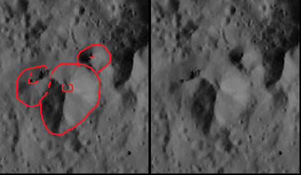
This is a volcanic chain of example, not very clear volcano, but an expert recognizes obvious signs of volcano, although it is a not classical volcano
Posted by: JohnVV Jan 28 2016, 01:35 AM
low angle renderings of that "volcano?"
http://imgbox.com/sTBGe07d http://imgbox.com/UHsiS2vp http://imgbox.com/sNvjSlru
bare mesh, mesh and a gray shader, mesh and the image texture
Posted by: Gladstoner Jan 28 2016, 02:15 AM
These is the only structures that seem cones, but perhaps just a coincidence ..
Plus, impact craters are more likely to be preserved on the summit of a mountain than on its slopes.
Posted by: ZLD Jan 28 2016, 09:24 PM
http://photojournal.jpl.nasa.gov/catalog/PIA20305
http://zldoyle.blogspot.com/2016/01/lamo-15.html
http://i.imgur.com/gsuiYGX.png
http://i.imgur.com/vxKdfo1.jpg
Posted by: Michael Capobianco Jan 28 2016, 11:25 PM
Finally, a look into Kerwan, the sand dollar.
Posted by: Gladstoner Jan 29 2016, 07:56 AM
Looks like a mini Haulani:
|
Posted by: ZLD Jan 29 2016, 06:07 PM
I didn't get to watch all of the SBAG Dawn presentation this morning. Hopefully I will get an update today from the NASA public affairs office about the recording and I will post it if available. From what I did see, it was a pretty good update to the status of the mission with lots of good slides and information. The slides should be posted by the end of the day which will include a pretty good shot of Haulani in LAMO. Below is a screen grab.
|
Also posted today was a nice animation from DLR, of a simulated flyover of Ceres, similar to the previous animation but with much higher resolution. https://www.nasa.gov/feature/jpl/new-animation-takes-a-colorful-flight-over-ceres
Posted by: ZLD Jan 29 2016, 07:23 PM
http://photojournal.jpl.nasa.gov/catalog/PIA20306
http://zldoyle.blogspot.com/2016/01/lamo-16.html
http://i.imgur.com/7AWbePK.png
http://i.imgur.com/TghiO0P.jpg
Posted by: Ken2 Jan 29 2016, 07:34 PM
So what's with those radiating 'bird feet'? If I saw those hills on Earth, I'd think they were an erosional remnant of a larger mountain. But on Ceres, there is no apparent process to remove the material in such a manner.
Most craters* start out as an empty cones, and in-fill by their ejecta and landslides, and the ejecta of countless other craters. The craters are filled of unstable relatively puffy fine-grained ejecta. Subsequent impacts cause huge Ceres-quakes which will cause landslides (clearly evident all over the place) and settling, which I believe is the majority of the cracks on crater floors.
*Most craters (other then young ones big enough to have lava in-fill at the time of creation, and very large ones (I don't know what that size is on Ceres, and it's probably a function of age))
e.g. old (earliest) craters have a harder surface which may rebound more. Also assuming it was mostly a molten interior at the time of formation, then the lava in-fill (and after a given crater could no longer expose lava) then elastic rebound would be decreasing as a function of age. The later craters would be formed in a puffy impact gardened surface which looks to be km thick. An impact in a loosely bound matrix would evacuate a clean cone and then have severe landslides back into the pit. It's even possible that most of the central peaks are in fact landslide conjunctions (i.e. if there are landslides all around the craters they would meet in the middle and after a few met the forming ridge/peak would accumulate subsequence landslide terminating debris as the crater in-filled. I think these type of processes may explain the majority of Cere's crater's features. I wonder what magnitude Cere's quake is generated for a given impact diameter and distance from the impact?
Just a visual update on my hypothesis:
|
The younger Kupalo Crater clearly shows landslide formed cracks and this view [below] from today's movie shows how the Dantu settling/landslide fault line cracks are most likely the same mechanism. ZLD's screen grab today (previous post) of Haulani in LAMO shows similar landslide cracks. Also the Kupalo and Dantu landslides both appear to end at the central "peak" area with a linear terminus pile-up. Note that landslides in .028g should travel much further then in 1g on earth.
|
Posted by: ZLD Feb 1 2016, 11:16 PM
http://photojournal.jpl.nasa.gov/catalog/PIA20307
http://zldoyle.blogspot.com/2016/02/lamo-17.html
http://i.imgur.com/98QO6eK.png
http://i.imgur.com/Ol7eFnc.jpg
Posted by: JohnVV Feb 2 2016, 02:55 AM
A few low angle renders from LAMO 16
http://photojournal.jpl.nasa.gov/catalog/PIA20306
http://imgbox.com/G6GIaNMI http://imgbox.com/jSLCbSvA http://imgbox.com/XXvToUkb http://imgbox.com/nPWr1U9F http://imgbox.com/IyHZsVDS
Posted by: ZLD Feb 2 2016, 07:21 PM
http://photojournal.jpl.nasa.gov/catalog/PIA20308
http://zldoyle.blogspot.com/2016/02/lamo-18.html
http://i.imgur.com/wxpfaz8.png
http://i.imgur.com/h4y5lbs.jpg
Posted by: JohnVV Feb 3 2016, 02:16 AM
lamo 18 - PIA20308
low angle illumination like this ( approx. 10Deg. ) is pushing things a bit
this required a lot of manual editing to correct the dem used
i had it inpaint the shadows and dodge and burn the heightmap
the first of the two is just a rendered mesh
the second has the texture draped over it
http://imgbox.com/UPUkZoWL http://imgbox.com/h8zjkqAV
http://imgbox.com/lC4jEGCL http://imgbox.com/rJhQUZJc
http://imgbox.com/ufErpjiH http://imgbox.com/c4YlaRj8
Posted by: ZLD Feb 3 2016, 07:16 PM
http://photojournal.jpl.nasa.gov/catalog/PIA20309
http://zldoyle.blogspot.com/2016/02/lamo-19.html
http://i.imgur.com/RphNhyO.png
http://i.imgur.com/AtrkyUi.jpg
Posted by: ZLD Feb 4 2016, 07:03 PM
http://photojournal.jpl.nasa.gov/catalog/PIA20310
http://zldoyle.blogspot.com/2016/02/lamo-20.html
http://i.imgur.com/VxNrdME.png
http://i.imgur.com/7YZqYsF.jpg
Posted by: ZLD Feb 5 2016, 06:45 PM
http://photojournal.jpl.nasa.gov/catalog/PIA20311
http://zldoyle.blogspot.com/2016/02/lamo-21.html
http://i.imgur.com/g3WLKFm.png
http://i.imgur.com/4VjNCJ7.jpg
Posted by: Habukaz Feb 8 2016, 05:29 PM
Aaand....we got http://photojournal.jpl.nasa.gov/catalog/PIA20312* 
* its western rim
Posted by: ZLD Feb 8 2016, 08:02 PM
http://photojournal.jpl.nasa.gov/catalog/PIA20312
http://zldoyle.blogspot.com/2016/02/lamo-22.html
http://i.imgur.com/cCpUSrr.png
http://i.imgur.com/CZ9LgOE.jpg
Posted by: JohnVV Feb 9 2016, 02:13 AM
LAMO-22 -- PIA20312
a few renders -- less impressive than i thought it would turn out
http://imgbox.com/Cu6Xdfhe http://imgbox.com/xRZC6iQi http://imgbox.com/dGVg0YVm http://imgbox.com/fFP5HKch http://imgbox.com/uyk2sw5B http://imgbox.com/KbQAT8kQ
Posted by: PDP8E Feb 10 2016, 12:12 AM
John, its very impressive!
Posted by: ZLD Feb 10 2016, 05:51 AM
http://photojournal.jpl.nasa.gov/catalog/PIA20313
http://zldoyle.blogspot.com/2016/02/lamo-23.html
http://i.imgur.com/9qILJsh.png
http://i.imgur.com/Xfv9iuD.jpg
Posted by: ZLD Feb 10 2016, 05:43 PM
http://photojournal.jpl.nasa.gov/catalog/PIA20314
http://zldoyle.blogspot.com/2016/02/lamo-24.html
http://i.imgur.com/E9CciRu.png
http://i.imgur.com/TKfnSZs.jpg
Posted by: ZLD Feb 11 2016, 05:58 PM
http://photojournal.jpl.nasa.gov/catalog/PIA20315
http://zldoyle.blogspot.com/2016/02/lamo-25.html
http://i.imgur.com/uz0LGSY.png
http://i.imgur.com/kE43ae8.jpg
Posted by: JohnVV Feb 13 2016, 06:14 AM
LAMO 26 - PIA20380
http://dawn.jpl.nasa.gov/multimedia/images/image-detail.html?id=PIA20380
this one has A LOT of small craters
http://imgbox.com/oYhFkvpe http://imgbox.com/5BMNAbrJ http://imgbox.com/5NDhexHn http://imgbox.com/u9wAKbFU
http://imgbox.com/R735lDeE http://imgbox.com/zuG82PFA http://imgbox.com/4oZXPFA2
Posted by: ZLD Feb 13 2016, 05:07 PM
http://photojournal.jpl.nasa.gov/catalog/PIA20380
http://zldoyle.blogspot.com/2016/02/lamo-26.html
http://i.imgur.com/SXlq10u.png
http://i.imgur.com/DiRi67g.jpg
Posted by: ZLD Feb 16 2016, 07:09 PM
http://photojournal.jpl.nasa.gov/catalog/PIA20381
http://zldoyle.blogspot.com/2016/02/lamo-27.html
http://i.imgur.com/a65xKEQ.png
http://i.imgur.com/4QOdZSU.jpg
Posted by: JohnVV Feb 16 2016, 09:08 PM
and the renders in Blender that go along with LAMO 27
http://imgbox.com/k4CayKu3 http://imgbox.com/8gQlsQbv http://imgbox.com/iug0gqSk
http://imgbox.com/oGxDgKub http://imgbox.com/k52ZC1Hz http://imgbox.com/AHmuZF1C
and a Google photo album of My LAMO renders
https://goo.gl/photos/iAtFUPmE4QVxpcY29
Posted by: ZLD Feb 17 2016, 01:38 AM
I feel like I hadn't seen some of those John. Those are all great!
Posted by: ZLD Feb 17 2016, 06:47 PM
http://photojournal.jpl.nasa.gov/catalog/PIA20382
http://zldoyle.blogspot.com/2016/02/lamo-28.html
http://i.imgur.com/GDyd7h2.png
http://i.imgur.com/Q84iBs3.jpg
Posted by: JohnVV Feb 17 2016, 07:27 PM
some might not have been posted here.
some were in the old hamo folder
and there a few that once i get a mesh and look at them in 3d , there is not much to look at
you end up with the problem of the vacation slide show pictures
Posted by: Ken2 Feb 17 2016, 08:41 PM
Here's a quick gif of HAMO vs LAMO. I didn't correct for altitude and look angle distortions so it's pretty rough - but it is a nice way to show the context and improvement on this pict (LAMO 28 - PIA20382 / PIA20000)
<Click to animate>
|
Posted by: Bill Harris Feb 18 2016, 01:52 PM
Comparison of the recent LAMO LO-28 image with an earlier HAMO image of episodic mass-wasting features.
https://univ.smugmug.com/Dawn-Mission/Ceres/i-nft4vTd/0/O/PIA20000--HO-57--orient--enh--annot--crop--res4x%2BLO28.png
Reference:
https://univ.smugmug.com/Dawn-Mission/Ceres/i-WKKq94r/0/O/PIA19896--HO-18--orient--annot.png
https://univ.smugmug.com/Dawn-Mission/Ceres/i-QXJbjqN/0/O/PIA20000--HO-57--orient--enh--annot.png
--Bill
Posted by: ZLD Feb 18 2016, 06:07 PM
http://photojournal.jpl.nasa.gov/catalog/PIA20383
http://zldoyle.blogspot.com/2016/02/lamo-29.html
http://i.imgur.com/OoLUo9r.png
http://i.imgur.com/IjTcIRA.jpg
Posted by: ZLD Feb 19 2016, 05:51 PM
http://photojournal.jpl.nasa.gov/catalog/PIA20384
http://zldoyle.blogspot.com/2016/02/lamo-30.html
http://i.imgur.com/2lmfTUM.png
http://i.imgur.com/QhncN7y.jpg
Posted by: JohnVV Feb 20 2016, 03:32 AM
Lamo 30 - PIA20384
http://imgbox.com/P8h3vpNq http://imgbox.com/T0LXYnUl http://imgbox.com/8O4iA7KO http://imgbox.com/Mnt37c7A http://imgbox.com/IXRa1bDV
Posted by: Bill Harris Feb 20 2016, 03:57 PM
Created a new Ceres Gallery today and moved images into it:
https://univ.smugmug.com/Dawn-Mission/Ceres-LAMO-Images/
--Bill
Posted by: ZLD Feb 22 2016, 07:36 PM
http://photojournal.jpl.nasa.gov/catalog/PIA20385
http://zldoyle.blogspot.com/2016/02/lamo-31.html
http://i.imgur.com/ZFRgyjQ.png
http://i.imgur.com/tAseTYG.jpg
Posted by: Habukaz Feb 23 2016, 05:32 PM
The latest image is http://photojournal.jpl.nasa.gov/catalog/PIA20386. I hope we get lots more of these.
Posted by: ZLD Feb 23 2016, 06:05 PM
http://photojournal.jpl.nasa.gov/catalog/PIA20386
http://zldoyle.blogspot.com/2016/02/lamo-32.html
http://i.imgur.com/HAWWWpt.png
http://i.imgur.com/mVCB7IG.jpg
Also, reoriented view of imaged region.
http://i.imgur.com/jkLThrn.png
Posted by: ZLD Feb 24 2016, 07:47 PM
Juling Crater synthetic animation. This transitions from HAMO 39 to LAMO 32 from yesterday.
http://zldoyle.blogspot.com/2016/02/juling-crater-h39-l32.html
Posted by: ZLD Feb 25 2016, 03:35 AM
http://photojournal.jpl.nasa.gov/catalog/PIA20387
http://zldoyle.blogspot.com/2016/02/lamo-33.html
http://i.imgur.com/EXAyRFB.png
http://i.imgur.com/1PA1WRn.jpg
Also, another orientation corrected view.
http://i.imgur.com/pbN30o0.png
Posted by: ZLD Feb 25 2016, 10:03 PM
http://photojournal.jpl.nasa.gov/catalog/PIA20388
http://zldoyle.blogspot.com/2016/02/lamo-34.html
http://i.imgur.com/oxeFPAl.png
http://i.imgur.com/62nq1Os.jpg
http://i.imgur.com/zSo3fko.gif
L29-L34
Posted by: Gladstoner Feb 27 2016, 09:49 AM
Dantu Crater mosaic:
|
(PIA20193, PIA20300, PIA20303)
Posted by: alan Feb 27 2016, 08:32 PM
The bright streaks on the crater walls, landslides of bright material or salt deposits left behind by flows of liquid?
Posted by: ZLD Feb 27 2016, 08:41 PM
http://photojournal.jpl.nasa.gov/catalog/PIA20389
http://zldoyle.blogspot.com/2016/02/lamo-35.html
http://i.imgur.com/prMLTfw.png
http://i.imgur.com/SyXGVmj.jpg
Posted by: JohnVV Feb 27 2016, 09:57 PM
a few renders of LAMO-35 PIA20389
http://imgbox.com/gJWYkBIv http://imgbox.com/2alR7PIN http://imgbox.com/eZAtnnNF
http://imgbox.com/Y0HTChyl http://imgbox.com/FaMkRlFm http://imgbox.com/GElqnlC7
in particular is the "wasting" area at the top of the image
Posted by: Gladstoner Feb 27 2016, 10:41 PM
My guess is that they are scattered/isolated deposits (veins?) of salt that were exposed by mass wasting of the crater wall.
Posted by: dvandorn Feb 28 2016, 03:20 PM
Considering the extensive emplacement of impact debris mantling units all over Ceres, I would guess the top 500 to 1,000 meters of the surface is a battered, crushed layer of poorly mixed, brecciated debris. There are quite likely a huge number of salt and salty ice deposits embedded within this debris layer.
When craters are made in this kind of surface, these pockets of high-albedo salt (or salty ice) become exposed; more are exposed as mass wasting deflates large crater walls. Thus, the occasional white spots and streaks seen in crater walls.
Now, this is completely separate from directly-emplaced cryovolcanic deposits, like what we appear to see in Occator. Those (and there are quite a fewer number of them than the smaller white spots) seem to be examples of deeper material moving volcanically up to the surface from deeper layers of soft salty ice (or even liquid salty water). That's a different emplacement mechanism from most of the small bright spots we see on crater walls, I think.
Think of it this way -- take a surface composed mostly of black sand, and randomly embed a bunch of white pebbles in it. Then hit it with an impact. Your resulting crater will show mostly black sand walls, but every once in a while a white pebble will poke out through the major black sand matrix of the unit. And as crater walls recede due to mass wasting, new white pebbles are exposed. Now, just replace the black sand with the general dark material of Ceres' surface and the white pebbles with concentrations of salt and/or salty ice, and you have a model for what may well be happening on Ceres.
Posted by: ngunn Feb 28 2016, 09:17 PM
Now, this is completely separate from directly-emplaced cryovolcanic deposits, like what we appear to see in Occator.
I think the first paragraph quoted describes very well the likely formation process for white spots. So why invoke a different process for Occator? Any 'activity' there could just be the mass wasting of freshly exposed ices you already mentioned.
Posted by: ZLD Feb 29 2016, 12:33 AM
I can't recall what conference was going on last week but I definitely saw some graphics pop up on Twitter that showed that the Dawn team is pursuing cryovolcanic processes for Occator. There was a nice side cut-away image as well. I'll try to find it and post if do. The possibility has been floated in several other recent talks as well.
Posted by: tanjent Feb 29 2016, 04:02 PM
If there are deposits of white salty material embedded at random locations in the regolith, then they should be uncovered more frequently around the rims of the craters than in the centers, should they not? Cryovolcanic scenarios do seem to fit a bit better better with the "bullseye" pattern we see in places like Occator.
Posted by: ZLD Mar 1 2016, 03:38 PM
http://photojournal.jpl.nasa.gov/catalog/PIA20390
http://zldoyle.blogspot.com/2016/03/lamo-36.html
http://i.imgur.com/C4tsY0x.png
http://i.imgur.com/hZUgEO5.jpg
Posted by: Bill Harris Mar 1 2016, 04:34 PM
Recent LAMO imagery and a current LAMO Index map:
https://univ.smugmug.com/Dawn-Mission/Ceres-LAMO-Images/
--Bill
Posted by: ZLD Mar 1 2016, 05:50 PM
http://photojournal.jpl.nasa.gov/catalog/PIA20391
http://zldoyle.blogspot.com/2016/03/lamo-37.html
http://i.imgur.com/hM3UQhm.png
http://i.imgur.com/BSqQ094.jpg
Posted by: JohnVV Mar 2 2016, 07:23 PM
LAMO -36 (PIA20390)
is a very low angle of illumination , the process i use dose not do a great job on these images
but a few areas look good
http://imgbox.com/TGSrXkrE http://imgbox.com/A5w9HZmb http://imgbox.com/QaVH3Rs9 http://imgbox.com/DnyRH4rV
http://imgbox.com/cxbptQSw http://imgbox.com/KDvYQ4Y1 http://imgbox.com/1AcsHE39
Posted by: ZLD Mar 4 2016, 05:23 AM
http://photojournal.jpl.nasa.gov/catalog/PIA20392
http://zldoyle.blogspot.com/2016/03/lamo-38_3.html
http://i.imgur.com/5ehaoZo.png
http://i.imgur.com/4Yk20WH.jpg
-----
http://photojournal.jpl.nasa.gov/catalog/PIA20393
http://zldoyle.blogspot.com/2016/03/lamo-39_3.html
http://i.imgur.com/wjEUPyG.png
http://i.imgur.com/OB1cnos.jpg
Posted by: charborob Mar 4 2016, 08:49 PM
LAMO 39-40 mosaic:
|
Posted by: ZLD Mar 4 2016, 10:04 PM
http://photojournal.jpl.nasa.gov/catalog/PIA20394
http://zldoyle.blogspot.com/2016/03/lamo-40.html
http://i.imgur.com/9LE0i0t.png
http://i.imgur.com/EtnvHIV.jpg
Posted by: Gladstoner Mar 5 2016, 06:02 PM
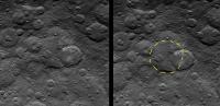
|
|
That ejecta seems to be more fluid than usual (as far as we've seen so far). In places, it resembles outflow channels on Mars.
Some context of Ikapati Crater....
HAMO image 64:
http://photojournal.jpl.nasa.gov/catalog/PIA20127
Survey Orbit image 30:
http://photojournal.jpl.nasa.gov/catalog/PIA19599
This ejecta seems to be mostly confined within the low point of a larger, older crater (outlined in yellow):
|
Posted by: ZLD Mar 5 2016, 07:38 PM
Was certainly thinking that as well Gladstoner. There is several very peculiar spots that look like very quick or non-viscous material moved quickly to fill the lower crater and surrounding area.
Posted by: Gladstoner Mar 6 2016, 07:55 AM
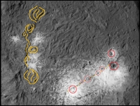
A checklist of interesting features in Ikapati Crater (labeled in image):
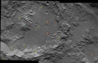
|
1. White spots. Their extent is minor compared to other craters.
2. Extensional fractures. These are on the floor, rim and ejecta.
3. 'Shotgun blast' pits. These seem to be more than mere clustered impacts.
4. Degraded central peak. The flat top (or pit?) contrasting with the fluted sides is quite interesting.
5. Fluvial-like flow structures.
Posted by: Bill Harris Mar 7 2016, 06:09 PM
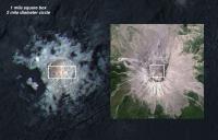
Ahuna. The closer we look, the more mysterious it becomes. I'm still thinking "my gawd, it's full of stars... "
--Bill
Posted by: Explorer1 Mar 7 2016, 07:01 PM
How large is the gap between the rim of the crater and Ahuna's slopes? The caption says 35 m/ pixel (http://dawn.jpl.nasa.gov/multimedia/images/image-detail.html?id=PIA20348), so less than a kilometer separation, by my count. Is it just a coincidence that the mountain is so close?
What an odd view one would have standing on the surface there, too...
Posted by: Gladstoner Mar 7 2016, 09:04 PM
That terrain on top of Ahuna.... It just seems to have no rhyme or reason. If anything, it appears like a souffle that has risen and collapsed back down a bit (with some subsequent mass wasting around the edges).
Oh, and that hanging valley on the west side of the summit is spectacular.
Posted by: ZLD Mar 7 2016, 10:56 PM
LAMO 41
http://zldoyle.blogspot.com/2016/03/lamo-41.html
http://i.imgur.com/3w3dlCf.png
http://i.imgur.com/H7GFxoP.jpg
-----
http://zldoyle.blogspot.com/2016/03/ahuna-mons-in-lamo.html
Cropped and enhanced:
http://i.imgur.com/qNgxaOA.png
Posted by: Bill Harris Mar 8 2016, 12:17 AM
I can't quite place with anything known. And the walls, NW to SE, still look rather vitreous and translucent. And the talus (or lack of) at the toe of the slope. I predict views with different lighting angles and a series of oblique views.
Here is a montage of Ahuna from SO6 through HO1:
https://univ.smugmug.com/Dawn-Mission/Ceres/i-pDjSWGX/0/O/tall_mtn_montage.png
--Bill
Posted by: JohnVV Mar 8 2016, 06:50 AM
for lamo "PIA20348"
this is what i get in Blender
http://imgbox.com/HWHRF4GQ http://imgbox.com/2ukenUFG http://imgbox.com/3Gv1S974 http://imgbox.com/C2VqEjco
http://imgbox.com/cDelWbdH http://imgbox.com/61Ih0CIj http://imgbox.com/Qj5YUMR3
and a 8bit copy of the heightmap
http://imgbox.com/R1AHOnK7
Posted by: Bill Harris Mar 9 2016, 03:06 AM
Added the new LAMO image of Acuna Mons to the SO-HO-LO series of image:
https://univ.smugmug.com/Dawn-Mission/Ceres-LAMO-Images/i-jGwLZCt/0/O/tall_mtn_SO-HO-LO_montage.png
--Bill
Posted by: ZLD Mar 10 2016, 03:53 PM
http://photojournal.jpl.nasa.gov/catalog/PIA20396
http://zldoyle.blogspot.com/2016/03/lamo-42.html
http://i.imgur.com/ICcGDPP.png
http://i.imgur.com/Ns9JH4y.jpg
Posted by: ZLD Mar 10 2016, 04:26 PM
http://photojournal.jpl.nasa.gov/catalog/PIA20397
http://zldoyle.blogspot.com/2016/03/lamo-43.html
http://i.imgur.com/0NbggwO.png
http://i.imgur.com/dAWxYF2.jpg
Posted by: Ken2 Mar 10 2016, 08:30 PM
this is what i get in Blender
...
and a 8bit copy of the heightmap
http://imgbox.com/R1AHOnK7
Nice renders, I think the height map is most telling - I sketched a few craters outllnes in dotted outlines. I think the upwelling of the mountain is part of the larger upwelling area (in solid outline), and because of the relatively fluffy old crater infill to the top left, it broke through at that spot.
I still think the only thing that can get that kind of energy to build a plateau is an impact on the other side (Dantu) and this is the antipode. The age of the two events also seems roughly similar (newish events)
P.S. Dawn just won the 2015 Collier Trophy - congrats to the team - thats a big deal! https://naa.aero/awards/awards-and-trophies/collier-trophy
|
Posted by: HSchirmer Mar 10 2016, 09:50 PM
If anything, it appears like a souffle that has risen and collapsed back down a bit (with some subsequent mass wasting around the edges).
Looks like a surface that is splitting as something intrudes, raises the overlying strata,
then intrudes a bit further, creating lens of material, an ice laccolith, er laccoglacius?
Think Shiprock in New Mexico or Lava Butte in Nevada.
Looking at the low "trail" behind the mountain, perhaps something like Hadley Rille on the moon.
As to the fractured terrain on top of Ahuna Mons, it's a fictional agriculture/terraforming name, but somehow, Shai-Hulud terrain seems to fit... If you like Dune...
clipped from above
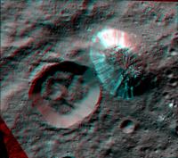
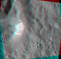
Posted by: atomoid Mar 10 2016, 10:21 PM
Rough crosseye/anaglyph incorporating HAMO/LAMO (http://photojournal.jpl.nasa.gov/catalog/PIA20348 and http://photojournal.jpl.nasa.gov/catalog/PIA19631) views, lighting differences complicating, fwiw...
|
|
Posted by: Bill Harris Mar 11 2016, 04:39 AM
then...
For sure. The closer the view, the more the mystery. In the region from Ahuna Mons up to the unnamed caldera at Liberalia Mons (LAMO-43) I see structural trends but oddly this does not carry over to the topo we have at "our" level. I'm looking forward to the papers forthcoming on these areas.
https://univ.smugmug.com/Dawn-Mission/Ceres-LAMO-Images/i-bxnggK2/1/O/PIA20147--HO-84--orient--enh%2BLO43%2BAhuna.png
--Bill
Posted by: JohnVV Mar 11 2016, 05:39 AM
A few close-ups of the mount -- rotating around it
http://imgbox.com/w2jiFPOL http://imgbox.com/0pbyfLPv http://imgbox.com/HFNDych9 http://imgbox.com/sCDgkVxZ
http://imgbox.com/mzTrnefv http://imgbox.com/d5QZjxvG http://imgbox.com/J3z3PMyK
http://imgbox.com/58Canr9M http://imgbox.com/YFYUSF0Z
Posted by: Gladstoner Mar 11 2016, 10:20 PM
Color-coded elevation map of Ahuna Mons:
http://photojournal.jpl.nasa.gov/catalog/PIA20399
|
Ahuna appears to be part of a broader plateau. Is it merely the most recently formed structure in an uplift and/or eruptive complex? The adjacent upland ('Ancestral Ahuna') shows no signs of recent uplift, i.e. it may have been pummeled beyond recognition by impacts. This reminds me of one of the Hawaiian islands, with an actively erupting shield and a surrounding complex of heavily eroded extinct volcanoes (not to say these Cerean structures have similar volcanics or tectonics.... and certainly not similar erosion).
Edit: Perhaps some of the other 'mons' around Ceres could be similar structures but are older and now unrecognizable.
Posted by: TheAnt Mar 13 2016, 04:04 PM
Edit: Perhaps some of the other 'mons' around Ceres could be similar structures but are older and now unrecognizable.
I agree, and noted the similarity to an Terrestrial uplift in the Blender-render images from JohnVV's post on March 8 - thank you JohnVV for your contribution.
On Earth such "uplifts" sometime happen in areas that have had an ice age, and mountains pop up again after having been pressed down by the ice.
I don't say that is the case here, and rather think it had to do with a change in mass distribution in one ridge already there but enhanced/caused by the nearby crater. This would also be the cause of the chaotic terrain on top. Even if my line of thought turn out to be wrong, I do think that Ahuna now is less of a mystery than in the early images.
Posted by: Bill Harris Mar 14 2016, 06:09 PM
I've looked at the topography and general structure for 200km around Ahuna Mons and although I've found some anomalous highs and lows, and lineations related to the Urvara impact, I've not seen a "smoking gun" related to Ahuna Mons. I'm still going to cubbyhole Ahuna in the "Peculiar" slot.
https://univ.smugmug.com/Dawn-Mission/Ceres-LAMO-Images/i-xXTMzK6/0/O/survey_map_occator-annot.png
--Bill
Posted by: ZLD Mar 15 2016, 01:56 PM
http://photojournal.jpl.nasa.gov/catalog/PIA20398
http://zldoyle.blogspot.com/2016/03/lamo-44.html
http://i.imgur.com/UnWJfsI.png
http://i.imgur.com/PAKbham.jpg
Posted by: ZLD Mar 15 2016, 03:20 PM
http://photojournal.jpl.nasa.gov/catalog/PIA20400
http://zldoyle.blogspot.com/2016/03/lamo-45.html
http://i.imgur.com/sOUCFiE.png
http://i.imgur.com/jkdm0wK.jpg
Posted by: dvandorn Mar 15 2016, 05:09 PM
Um, wow... that has to be one of the freshest craters we've seen in the LAMO campaign. Look at all those boulders!
Um, again -- I should know this, but, what size are those boulders? A lot of them are three or more pixels wide, what's our pixel resolution from LAMO right now, on average?
edit -- I asked above because I doubted this, but is it true that the "dot = 35m" at the bottom of the image really means we have 35 meter resolution? If that's the case, some of those boulders are 300 meters across, or more.
-the other Doug
Posted by: ZLD Mar 15 2016, 06:15 PM
Yeah, that dot is the correct scale - 2 pixels is approximately 35 meters with the 200% increase in my context image.
Posted by: Explorer1 Mar 15 2016, 06:36 PM
It's a hallmark of that low surface gravity of 0.27 m/s; even something that massive can travel a long way...
Posted by: ZLD Mar 15 2016, 06:49 PM
http://photojournal.jpl.nasa.gov/catalog/PIA20401
http://zldoyle.blogspot.com/2016/03/lamo-46.html
http://i.imgur.com/FOM73um.png
http://i.imgur.com/4AvvQhz.jpg
I'm not going to pretend like this wasn't painful to find. Haha.
Posted by: dvandorn Mar 15 2016, 08:32 PM
In re LAMO 45 again, not only do we see boulders up to at least 200 meters in their longest dimension, with an awful lot in the 50-meter range, the immediate ejecta blanket is extremely distinct, particularly the extraordinarily distinct edge of the ejecta blanket itself. Boulder streams are also well aligned with the patterning in the ejecta blanket. This is a wonderful example of impact cratering, actually...
There are literally hundreds of 50- to 500-meter craters in the imaged terrain outside of the ejecta blanket, while there are less than 10 of that size (and less than half of that are 500m or more) on the imaged portion of the blanket. In fact, much of the ejecta blanket is entirely crater-free; what patches of craters that do appear in a couple of spots look like they may be patterns of secondaries from only one or two close-by impacts.
We don't have an empirically derived impact flux for Ceres, but I would think a surface this crater-free would have to be awfully young, geologically speaking. Hence my enthusiasm for a very young-looking crater, here...
-the other Doug
Posted by: volcanopele Mar 15 2016, 09:32 PM
I wonder if that might be due to a difference in the impact flux of micrometeorites/small meteoroids compared to similar, airless surfaces we've seen at this scale, which in this size range, have all been moons. Moons would receive the typical background flux of those size objects, just as Ceres would, but there are also secondaries and sesequinaries to consider. The sesequinaries, chunks of material blasted out from other moons in the system or from the same moon but which take a longer path to come back than just a simple ballistic one, might be making relatively fresh craters in the outer solar system and the Moon look older than they otherwise would.
Posted by: Bill Harris Mar 16 2016, 02:13 AM
There are so many oddities of these impact "ejecta blankets" that I tend to think additionally of caldera "effusive blankets". These are the heady days of data collection; we still need to sit back and model processes.
--Bill
Posted by: charborob Mar 18 2016, 07:37 PM
Mosaic of LAMO 39-40-49 images (Ikapati crater):
|
Posted by: Steve5304 Mar 18 2016, 08:43 PM
when do we see Spot 5. I can't wait at that sort of resolution my imagination is going nuts
Posted by: JohnVV Mar 19 2016, 01:28 AM
a few images from lamo 49
http://imgbox.com/wLcFYD14 http://imgbox.com/3ZA14AOt http://imgbox.com/iV2SHB8m http://imgbox.com/eyOdKBVx
Posted by: Phil Stooke Mar 21 2016, 03:58 PM
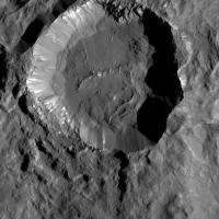
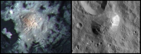
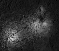
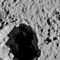
Hot from LPSC - we were shown a well-exposed image of the large bright spot in Occator. It has central fractured dome surrounded by a shallow discontinuous 'moat' and slightly elevated outer parts. It is bright, but not ice, so some kind of salt or bright mineral.
I expect there will be a release soon, as it has now been shown.
Phil
Posted by: Explorer1 Mar 21 2016, 04:16 PM
Low res pic from someone in the room (for those who can't wait)
https://twitter.com/Laurent_Montesi/status/711938488300515328
Posted by: JohnVV Mar 22 2016, 04:12 AM
a few from LAMO 50
http://imgbox.com/0EiC2QyA http://imgbox.com/og5lfcFh http://imgbox.com/PNgiuW2z http://imgbox.com/MvZe5i9v
i am running into the "vacation slide show that never ends "
so people please point out spots on images YOU!!! want to see
Posted by: charborob Mar 22 2016, 05:25 PM
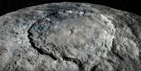
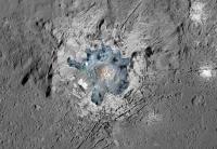
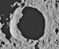
Among today's image release is a large mosaic of http://dawn.jpl.nasa.gov/multimedia/images/image-detail.html?id=PIA20350 showing exquisite detail.
Posted by: peter59 Mar 22 2016, 05:26 PM
High res mosaic
http://photojournal.jpl.nasa.gov/jpeg/PIA20350.jpg
Posted by: Habukaz Mar 22 2016, 05:50 PM
So, basically, there's a bright white mountain in the centre of the crater. I'd like to get an oblique view of that..
I am https://twitter.com/jccwrt/status/712332068542242817 reminded of Enceladus, though it was the similarity of the central dome to craters like that that struck me.
Posted by: ZLD Mar 22 2016, 07:18 PM
Haven't used this process for a while but here is a blink animation I did a long while back for sub-pixeling an image of Occator in Survey Orbit.
The image is blinking between the original cropped view from http://photojournal.jpl.nasa.gov/catalog/PIA19584, the sub-pixeling version and finally Occator in LAMO. The final LAMO image has been skewed because the original image of SO was somewhat oblique in view.
|
I'm rather intrigured so many details seem to remain consistent while others seem present but shifted due to the nature of the original low resolution.
Posted by: Bill Harris Mar 22 2016, 08:50 PM
The spots a fumaroles, unremarkable except for their size and presumably duration of activity. Even then, the whole Occator region is remarkable.
https://univ.smugmug.com/Dawn-Mission/Ceres/i-CmsS2zS/0/O/PIA19889--occator--geomorphology--v1.png
--Bill
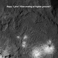
Posted by: atomoid Mar 22 2016, 09:38 PM
Looks almost like lava/mud flow at the edges of the http://photojournal.jpl.nasa.gov/catalog/PIA20350 where it appears to have pooled up and cooled as the level raised against the terrain barrier, forming the raised edge at the pool boundaries.
Also dont miss the http://dawn.jpl.nasa.gov/multimedia/images/image-detail.html?id=PIA20355 version.
Posted by: TheAnt Mar 22 2016, 09:49 PM
Wonderful, and finally, Occator in exquisite detail. To backtrack a bit, the impact hypothesis is out, and the idea of water ice seem less likely now.
So salt is the winner, salts that have built up around fumaroles that carry salty water from the interior or Ceres.
Several images including one in colour http://dawn.jpl.nasa.gov/news/news-detail.html?id=6168.
Posted by: stevelu Mar 23 2016, 12:13 AM
Thank you. It highlights for me that there seems to be a 'bright spot within the bright spot', quite small, in the extended filigree at around 10-o'clock.
A very fresh salt patch? Brightly-lit sports arena?
Posted by: Ken2 Mar 23 2016, 12:39 AM
I agree, as if most of the deep floor of Occator was flooded (perhaps shortly after impact), and the light areas are the erupting / venting leftovers
Here's a closeup of one of the apparent flow edges.
|
Posted by: Gladstoner Mar 23 2016, 02:21 AM
Some very preliminary observations and thoughts about Occator (some may have been mentioned already):
- The radial fractures at the center, surrounded by concentric fractures, seem to imply at least one cycle of uplift and subsidence.
- Could this be a variation of the process that produced Ahuna Mons?
- Most, if not all spots have a central crater-like structure.
- The dark areas on the west side of the main spot (with sharp boundaries) may be more recent talus slopes.
- The 'secondary' spots could be material that escaped from the central conduit. It could have moved along radial fractures.
- (Edit:) The spotty distribution of bright material in the smaller spots is interesting.
- The floor of Occator resembles a chunky stew. This could be the original impact melt.
Posted by: Gladstoner Mar 23 2016, 02:37 AM
And then there is this dramatic radial fracture system:
|
Could something else be trying to push up?
Posted by: David Palmer Mar 23 2016, 11:19 AM
Finally, with the lowest orbit of Dawn, the bright spots have been sufficiently resolved to understand their true nature.
Evidently the impact that created Occator Crater punched through into the subsurface ocean of Ceres, and created a weak spot that has henceforth served as a conduit for cryovolcanic outflows.
The main bright spot is inside of what appears to be a volcanic caldera, a depressed area with concentric cracks around (and inside) its perimeter, produced through the collapse of the roof of a "magma" chamber after its contents were extruded. And in the center of the caldera we have fresh dome-building, where slush is apparently pushing up (quite possibly in preparation for another significant eruption in the future), and this has caused radial cracks in the center (on the slopes of the dome) where the crust has been stretched.
This is extremely similar to the processes and landforms characterizing terrestrial volcanism, the only difference being that water is the "magma" in this case.
And just as with terrestrial volcanoes, we have outlying "cinder cones," apparently associated with fractures pointing radially away from the central caldera.
While it might be suggested that these features are simply a relic of ancient hydrothermal activity spawned by the heat of the original impact, the fact that this terrain is relatively free of craters is indicative of recent and even ongoing activity, plus the observations of apparent vapor above the floor of Occator Crater, in a diurnal cycle, indicate the same. Because unless there were ongoing outflows, any such volatiles would have sublimed away to nothing long ago.
The processes occurring here are similar to what I have suggested in my "artesian hydrant" model for the otherwise-inexplicable geology of Mars' Mt. Sharp. Namely that there are conduits connecting the surface of Mt. Sharp to an underground aquifer, and which are still occasionally active, and which I deem necessary to explain the relative youth of the channel and delta deposit to which Curiosity is currently headed (an aqueous-derived landform that has a relative lack of both cratering and erosional damage).
I would predict that Ceres will become an extremely hot target for exobiological research, with a huge push for a sample-return from Occator Crater, as any recent outflows might contain not only fossil organisms, but possible viable ones that could be revived, if an outflow were sufficiently fresh. And given the relatively small mass of Ceres, landing on it and taking off would be relatively easy with existing technology (its mass is only about 1/700 that of Mars and 1/90 that of Earth's moon).
Posted by: Daniele_bianchino_Italy Mar 23 2016, 11:44 AM
The image is blinking between the original cropped view from http://photojournal.jpl.nasa.gov/catalog/PIA19584, the sub-pixeling version and finally Occator in LAMO. The final LAMO image has been skewed because the original image of SO was somewhat oblique in view.
|
|
I'm rather intrigured so many details seem to remain consistent while others seem present but shifted due to the nature of the original low resolution.
Compliments ZLD, very similar to original after many month!
Some impressions, but I could be wrong:
images 1. These structures resemble a cinder cones or volcano Domes...
|
|
images 2. These structures, SW out of the Occator crater, resemble a caldera...
|
images 3. These structures, "onion" shaped, they are located along a probably fracture.. The three (or more) craters in the bright material, are calderas? or impact craters that was fall on the material? Even they are located along a probably fracture...
|
images 4. An evident flux material visible NW of Occator crater, almost end of the image
|
Ps: Do you think that lines above 0ccator crater dome center are similar to the lines above of Ahuna Mons ?
|
Posted by: Daniele_bianchino_Italy Mar 23 2016, 12:01 PM
Hi David, While I was writing was not yet arrived your answer! then I was right? :-)
Even organisms? on a so 'small body and first of atmosphere?
You mean living organisms in a probable underground ocean? past or present?
Posted by: xflare Mar 23 2016, 02:51 PM
It looks a bit like a lava dome to me minus the lava
|
Posted by: Bill Harris Mar 23 2016, 03:07 PM
http://imgbox.com/0EiC2QyA http://imgbox.com/og5lfcFh http://imgbox.com/PNgiuW2z http://imgbox.com/MvZe5i9v
i am running into the "vacation slide show that never ends "
so people please point out spots on images YOU!!! want to see
I like those secondary clusters-- 3D at an oblique angle is so dramatic. LO-50 is located NW of Oxo caldera at N61 345E.
--Bill
Posted by: Xcalibrator Mar 23 2016, 03:49 PM
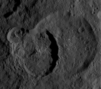
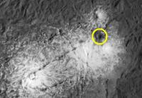
This crater (volcanic? impact?) caught my eye as it's dark and surrounded by dark material. If it's from an impact, did it somehow create/lead to the fractures it intersects with, and does this provide info on when and how quickly these events occurred? If volcanic/vent, why is the outflow/vented material dark instead of light?
|
Posted by: jccwrt Mar 23 2016, 04:29 PM
It looks like it's an impact crater coincidentally superimposed on the fracture system. If you look carefully the crater is almost tangential to the fracture. My guess is that it's just covered the bright salt deposits with darker crater floor material excavated from underneath. That's telling us that the salt deposits are relatively thin, because at most they're not as thick as the crater is deep. Considering the amount of dark ejecta, they're probably significantly less so.
Posted by: Ken2 Mar 23 2016, 05:22 PM
More observations of this amazing area (munching popcorn)...
Pict #1:
The circled areas look like smaller domes. The left one is reasonably high judging from the shadow. wish we could get in closer...
The square box looks like a vent flow - the lava flow seems to flow over the older vent/caldera/crater in the top middle of the box
|
Pict #2:
The main little white spot is hard to find the source of - I dimmed the pict and think it's a very large caldera, but hard to tell for sure.
|
Posted by: Ken2 Mar 23 2016, 06:25 PM
Just for easier visualization to see what was going on, I superimposed the nice color dome pict over the higher brightness large grayscale mosiac. It's a little ungainly, but I like the integrated view.
|
Posted by: alan Mar 23 2016, 07:12 PM
Occator in 3D: https://twitter.com/Toy_Meister/status/712713108511436800
Posted by: Ken2 Mar 24 2016, 10:42 PM
A sense of scale compared to a terrestrial volcano (Mt St Helens in Washington) (1 mile = 1.6 km). Not sure if anyone has the exact height info yet.
|
Posted by: TheAnt Mar 27 2016, 11:23 AM
Also I wondered when looking at the high resolution image, also the features left and right of your circle might be calderas.
I also noted the dark feature pointed out by Xcalibrator in a post below, and thought it to be an impact crater.
That is not surprising considering that the age of Occator now is estimated to be 80 million years.
(In fact I tended to think it was even younger with so few craters.)
Anyway, these bright spots now seem to be made by some kind of water vulcanism. Even so, this might still not be conclusive proof that there's a current ocean deep in Ceres interior.
Have anyone considered that the energy from the impact itself might have have created a near-surface pool of meltwater that lasted some ~10 kiloyears that would also explain the fractures and 'flux material seen here?
Posted by: nprev Mar 27 2016, 11:45 AM
Definitely a possibility. There are very few similar features on Ceres, and Occator is by far the largest and most prominent. I would expect such features to be more common if they were purely endogenic, but of course that's just an opinion.
Alternatively, this may mean nothing more than that the icy crust is extremely thick and/or lacks deep cracks almost everywhere but a few select spots like this. Insufficient data at this time.
Posted by: David Palmer Mar 31 2016, 09:16 AM
As far as the origin of the mysterious pyramid-shaped mountain (Ahuna Mons), I find it to be a bit too much of a coincidence that there is a relatively young crater of approximately the same size right next-door, and can't help but suspect that there is a connection. And I would like to suggest the following model: as the largely-water-ice crust of Ceres has continued to thicken over time (due to the internal heat source gradually running down), cracking of the crust has occurred, some of which would be polygonal in shape, and I would suggest that the crater-creating impact occurred right next to one such polygonal section, and the resultant pressure impulse in the subsurface ocean (slightly) popped that section up through the surrounding crust. And since that time, continued freezing in the subsurface ocean has pushed the polygonal section further upwards, in response to vertical pressure created by expansion of the freezing water below, and due to the fact that the cracks defining its edges (cracks which became vertical faults) de-coupled it from the surrounding crust and allowed it to move fairly independently of that crust. So this mountain is basically what is referred to as a "horst" in Earth geology, but because of the differences in crustal composition and dynamics here, there are no surrounding "grabens," and Ahuna Mons doesn't take the shape of the linear ridge that is typical of terrestrial horsts.
Posted by: JohnVV Apr 1 2016, 01:26 AM
LAMO 53
a few renders at a low angle
http://imgbox.com/qxp1D4Zx
http://imgbox.com/zJuQsUbx http://imgbox.com/ZxCzhbKL http://imgbox.com/NbOxGzLM http://imgbox.com/7tnhANJJ
http://imgbox.com/nKtBuRNQ http://imgbox.com/4SV8q7e6 http://imgbox.com/ZvxVj23z
Posted by: Gladstoner Apr 1 2016, 07:28 AM
A summary of the formation of salt deposits as I imagine it. Many, if not all points here have or may have been mentioned or thought of already.
1. Ceres originates as accretion of rocky material and water.
2. Early, heavy meteoritic bombardment depletes crust and/or mantle of water. This possibility was mentioned somewhere recently; I had suspected this as well since the rough terrain seems to preclude water ice.
3. Differentiation of ice and rock/metal leaves ocean and/or water-rich zone in mantle, which probably occurred during bombardment mentioned above.
4. Interior water progressively freezes out, leaving increasingly concentrated salts in the remaining brine. I am reminded of pegmatites in terrestrial magmatic systems.
5. Some brine migrates toward the surface, often drying out and leaving behind deposits of salt. These are often exposed by impacts and mass wasting.
6. In some cases, the effects of large impacts manage to penetrate deep enough to reach some remaining brine at the water-rich level.
7. The highly fracture central rebounds of the large impacts provide conduits for the movement and ascent of brine. Occator is probably the most recent example of this process. Older craters, like Dantu and Ezinu, seem to show signs of reduced or extinct activity. Interestingly, these types of craters seem to be clustered over a broad area, but this may be a bias of impact occurrence and observation so far on our part, at least:

|
8. Ahuna Mons may be an example of a process similar to that of the Occator central uplift, but occurring in different conditions.
9. Other large salt-rich spots, like Haulani and Oxo Craters, are probably chance impacts into particularly salt-rich material.
Posted by: Ken2 Apr 4 2016, 04:58 PM
Just FYI, an interesting new study (see link) to help explain the very long runouts of the crater wall landslides all over Ceres.
http://phys.org/news/2016-04-vibrations-large-landslides-fluid.html
Posted by: Gladstoner Apr 6 2016, 07:22 PM
For those who haven't seen the 'Unveiling Ceres' animation:
http://photojournal.jpl.nasa.gov/catalog/PIA20537
Some video screen captures:
Haulani Crater:

|
Oxo Crater:

|
Urvara Basin central peak:

|
Posted by: Explorer1 Apr 7 2016, 04:26 PM
New Dawn journal from Marc Rayman: http://dawnblog.jpl.nasa.gov/2016/03/31/dawn-journal-march-31-3/
Posted by: JohnVV Apr 9 2016, 11:01 PM
just a few from LAMO 63
http://imgbox.com/pVIGdjyL
http://imgbox.com/ALlnZQqO http://imgbox.com/uec1pNTj http://imgbox.com/w07AGUgf
Posted by: JohnVV Apr 12 2016, 07:52 PM
a bit out of order
LAMO 55
http://imgbox.com/yZhg30Nw
http://imgbox.com/nkQMWKqH http://imgbox.com/JNYevRni http://imgbox.com/7IgBoNWz
http://imgbox.com/8HWBkx5s http://imgbox.com/peHTaZzJ http://imgbox.com/NAo6PLRa http://imgbox.com/YBC3Wj9v
Posted by: Ken2 Apr 13 2016, 04:18 PM
Based on that - it looks like the wheels are still holding out and hydrazine is still left. I think the project should seriously consider going to a lower orbit now to image the key sights at an even higher resolution. At this point it is 100% bonus time and the 2x-4x higher resolution would be invaluable for science - especially of the white spots. Now is the time - is there planetary society petition or something to try and make this happen?
Posted by: Explorer1 Apr 13 2016, 06:55 PM
It's not a technical reason they're remaining at this altitude. I recall the entire point of stopping at LAMO was to prevent Dawn prematurely crashing into the surface (you really don't want to run into Ahuna Mons by accident!)
Higher orbits are stable enough to stay for a much longer timescale, enough to sterilize the spacecraft (though nearly a decade in space ought to be enough time, IMHO!).
We might just have to wait for Dawn 2....
Posted by: elakdawalla Apr 13 2016, 07:00 PM
The project's plans have been made years in advance based upon countless hours of work of the science team and navigators, and represent's the project's best plans for achieving all the science goals of the mission within constraints of capability, budget, planetary protection, and everything else. The people who know the mission best have determined its course. We'd have no interest in petitioning them to change their plans, and wouldn't expect the project to listen to us if we did.
Posted by: scalbers Apr 13 2016, 08:13 PM
We could always respond to the blog post and contact Marc as individuals on our own behalf whether that could possibly be considered.
Posted by: Gladstoner Apr 13 2016, 08:36 PM
Speaking of waiting until Dawn 2, a couple questions:
1. Can Dawn directly determine the nature of a water-rich layer within Ceres, e.g. with gravity data? Or will this have to wait for a future mission?
2. Have theoretical constraints on the nature of such a layer been determined? The rough, 'rocky' terrain seems to preclude a pure layer, while the scattered deposits of salts seem to imply some differentiation from a homogeneous rock/ice mixture.
Posted by: Ken2 Apr 15 2016, 07:23 AM
A few counterpoints and I'll drop the subject
- Unlike almost every other mission which has time to plan and execute extended mission plans / pitch them to NASA HQ (Deep Impact,Stardust,Cassini, Messenger final imaging etc etc), Dawn has a very short window and can't reasonably go through that process. Missions are focused on the prime mission and don't do much if any extended mission studies until very late in the game - and given how little resources Dawn had left to just complete the prime mission means it is unlikely that much effort was able to be spent on an extended mission.
- Dawn saves hydrazine when on it's ion engines so can afford to lower it's orbit with a low hydrazine cost.
- Planetary protection arguments for a nuclear free Dawn are dubious at best when we routinely crash lunar orbiters and recently Messenger into mercury. Even so, a much lower orbit would still yield plenty of sterilization time.
- A Dawn2 is very unlikely to happen in the foreseeable future, we have a ~half billion dollar asset in good health there now and we have only have months to get an extended mission done
- The planetary society is very influential in US planetary circles
- Dawn is a tax payer funded mission and we as tax payers should want to get the most bang for our buck - and high value more risky extended mission science is has a good ROI.
In any event it just seems an unnecessary shame - much higher resolution images would be very valuable and should be doable.
Posted by: Mariner9 Apr 15 2016, 07:46 AM
Hey, I dream about higher resolution pictures of Occator as much as the next guy. However, I think something is being assumed here, namely that the primary purpose of the LAMO has been achieved by completing the higher resolution imaging of Ceres. But that is only part of the LAMO science objective. If I recall correctly the main point of the low orbit is to gather a good data set for the Gamma Ray and Neutron Detector. From what I remember reading years ago about a similar instrument on Mars Odyssey, the more orbits you collect data the better your composition data becomes. Lots of math algorithms crunching lots of science numbers from lots of data points yielding a higher and higher resolution composition map. So the longer they can maintain Dawn in a stable orientation to collect it's data, passing multiple times over the same terrain, the better their composition map becomes.
I think the Dawn team intends to keep that data set expanding as long as possible. Trying to power Dawn down to a lower orbit, as juicy as those new pictures sound, would put an end to the LAMO data collection for the GRAND instrument.
Again, most of this is my recollection, explained with lots of hand waving and general vague notions.
Posted by: Holder of the Two Leashes Apr 15 2016, 08:44 PM
Ending the mission early would sacrifice filling in as much of the south polar region as possible. It will be November before the solstice arrives and Ceres begins to get primary illumination in the southern hemisphere. For several months after that there will be more and more of the southern polar areas coming out of shadow where they are locally depressed (like basins). If those areas don't get photographed in the coming months, it could be decades. That plus what Mariner9 mentioned.
Posted by: Gladstoner Apr 15 2016, 09:28 PM
1. Can Dawn directly determine the nature of a water-rich layer within Ceres, e.g. with gravity data? Or will this have to wait for a future mission?
2. Have theoretical constraints on the nature of such a layer been determined? The rough, 'rocky' terrain seems to preclude a pure layer, while the scattered deposits of salts seem to imply some differentiation from a homogeneous rock/ice mixture.
I gather we'll have to wait for seismology on future missions.
Posted by: David Wright Apr 16 2016, 03:04 AM
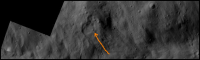
I spotted an interesting light-colored patch inside one of the smaller craters in LAMO 68. If I lighten the shadows I see this lobate object on a north-facing slope:
|
What do you think? It doesn't look like an artifact to me.
David
Posted by: JohnVV Apr 16 2016, 03:31 AM
not much lighter
px value of 24 in a 23 background
false color
http://imgbox.com/uewHtLto
Posted by: David Wright Apr 16 2016, 05:45 PM
I agree it's not much. But look at two other high latitude craters:
PIA20409
|
and PIA20407
|
The (admittedly faint) shadow detail in the first seems real, esp. compared to the second.
Posted by: JohnVV Apr 16 2016, 05:55 PM
seeing as the images on the photo journal are normalized 5% to 95% 8 bit jpg's
and the pds img files are 16 bit unsigned
http://sbn.psi.edu/archive/dawn/fc/
we really will need to see the EDR's to get any details
Posted by: JohnVV Apr 18 2016, 05:13 AM
LAMO 68 is at the edge of getting good looking mesh
http://imgbox.com/pcEZH0Wm
http://imgbox.com/FZdiNupC http://imgbox.com/HV11WPxx http://imgbox.com/6cqzkwFi
Posted by: fredk Apr 20 2016, 04:47 PM
New Scientist https://www.newscientist.com/article/2085288-nasas-dawn-probe-may-visit-third-asteroid-after-ceres-and-vesta/ that there's a proposed extension to a third asteroid.
Posted by: antipode Apr 20 2016, 10:13 PM
Not to mention the fact that there are only 2 reaction wheels left.
I would love to see this happen, but dont see how it could.
A flyby of 3 Pallas was once mooted - now THAT would have been exciting. Sadly that cant happen now. Discovery proposal anyone?
P
Posted by: Explorer1 Apr 21 2016, 02:15 AM
There must be something on a very similar orbit to Ceres; the delta-v remaining is pretty low by now. It would be great to see but Dawn isn't really built to do flybys, is it? Wonder how much Dawn can actually accomplish on a short time scale with a moving target (just tempering my enthusiasm...)
Posted by: Mariner9 Apr 21 2016, 03:52 AM
The target asteroid only needs a similar orbit if the purpose is to match velocity and achieve orbit around it. If just a flyby is all that is required, then the target could be in a very different orbit from Ceres that Dawn could intersect at the appropriate time.
I rather doubt they would go to the effort to escape Ceres just to do a flyby, because as it has been pointed out the spacecraft was designed with orbital studies in mind.
Posted by: JohnVV Apr 23 2016, 03:39 AM
Release LAMO 71
http://imgbox.com/AG4wOVCi http://imgbox.com/Hm4m5Bms http://imgbox.com/IHpyRUx2 http://imgbox.com/NlpLwmmO http://imgbox.com/aE3IrHBe
Posted by: nprev Apr 23 2016, 05:43 AM
Seems that there really is a http://www.universetoday.com/128547/dawn-just-wants-make-probes-look-bad/ for a mission extension to visit another asteroid.
Be interesting to see how this plays out in terms of getting an extension given the spacecraft's overall health. The strongest argument in favor of this may be to prevent Dawn from crashing into Ceres at EOM.
Posted by: HSchirmer Apr 23 2016, 12:57 PM
Be interesting to see how this plays out in terms of getting an extension given the spacecraft's overall health. The strongest argument in favor of this may be to prevent Dawn from crashing into Ceres at EOM.
Well, perhaps a fly by of a short period comet is possible, more interesting would be a gravity assist from a comet,
but since the spacecraft is designed to survey from orbit, and the only thing big enough to orbit seems to be Pallas,
I'm betting on Pallas in 2018-2019.
Posted by: fredk Apr 23 2016, 02:25 PM
To be fair, that just refers to the original New Scientist story. It would be good to get independent confirmation, though NS is usually reliable in these matters.
I wonder how hard it would be for someone here to work out the delta v's for some potential new flyby targets. Do we have an estimate of the remaining delta v? Is there some minimal science that could be done in flyby?
Posted by: Mr Valiant Apr 23 2016, 03:44 PM
I think we should squeeze as much data from Ceres as the mission allows.
SF has always viewed Ceres as a staging post between the inner and outer
Solar System. Initial results (brine/subsurface H2O) makes Ceres
appear as a nice, some may say, balmy stop over.
Posted by: Steve5304 Apr 23 2016, 05:08 PM
Why cant we just go an even lower descent on Ceres. Or are we not calibrated for that?
A new target does not make a lot of sense imo, it wont be anything bigger than a few football fields unless there is something i am missing
Posted by: HSchirmer Apr 23 2016, 05:31 PM
I wonder how hard it would be for someone here to work out the delta v's for some potential new flyby targets. Do we have an estimate of the remaining delta v? Is there some minimal science that could be done in flyby?
Eh, rough numbers - Dawn 425kg of xenon, and delta-v of 1000m/s uses about 25kg of xenon.
http://dawn.jpl.nasa.gov/mission/popups/faq_qa_M3.asp
Planned to use about ~275kg to get to vesta and then ~110kg to get to Ceres and spiral down to orbit.
Estimates were ~40kg of xenon would be left at the end of the Ceres orbit, that would be 1,600m/s.
Estimates for escape velocity from ceres low orbit, googling suggest around 400m/s.
Interesting, so Dawn might have enough xenon to break ceres orbit and still have over 1,000m/s of thrust left.
Posted by: mcaplinger Apr 23 2016, 06:29 PM
Pallas is too inclined to the ecliptic to reach. From http://dawn.jpl.nasa.gov/mission/faqs.asp, Marc Rayman says
BTW, you can't do effective gravity assists from small bodies. See "Tethers and asteroids for artificial gravity assist in the solar system", http://arc.aiaa.org/doi/abs/10.2514/3.25086?journalCode=jsr
Posted by: Paolo Apr 23 2016, 07:31 PM
for orbiting no doubt, but you can fly by it when it cuts through Dawn's orbital plane
Posted by: HSchirmer Apr 23 2016, 08:16 PM
Yep, which is why I said 2019; that's (roughly) when Pallas crosses the ecliptic plane.
-edit- actually Pallas crosses in 2017 and 2019...
And 2019 also happens to be when Pallas comes closest to Ceres.
It will be interesting to see whether the choice of words is significant,
e.g. "visit another asteroid" versus "orbit another asteroid"
Posted by: nprev Apr 23 2016, 08:37 PM
Really can't see this as being anything other than a flyby, and with a limited chance of success at that given the age and health of the spacecraft. In fact, I would characterize it as a sort of enhanced end-of-mission disposal plan. Main goal does seem to be ensuring that Dawn doesn't impact Ceres and thus violate the planetary protection protocols.
NOTE: If this becomes confirmed as a real thing we'll split it off as its own thread. Main focus here will continue to be LAMO operations, of course.
Posted by: JohnVV Apr 29 2016, 05:18 AM
LAMO - 77
http://imgbox.com/YjfaG5Jx
a few , there is a interesting dip in the rim and ripples in the floor of the crater
http://imgbox.com/jJ8hKbTg http://imgbox.com/XmfDO8o1 http://imgbox.com/C0N6wYtw http://imgbox.com/7UYVCNnz
Posted by: Bill Harris May 4 2016, 03:48 PM
New LAMO Index map to LO-79 and a montage of Messor caldera (LO-1 + LO-77).
https://univ.smugmug.com/Dawn-Mission/Ceres-LAMO-Images/
--Bill
Posted by: Explorer1 May 4 2016, 07:24 PM
Interesting quote from this month's http://www.planetary.org/blogs/guest-blogs/marc-rayman/0504-dawn-journal-a-new-angle-on-ceres.html
Not ruling anything out apparently...
Posted by: atomoid Jun 6 2016, 10:43 PM
No big releases, just looking forward to completing the http://dawn.jpl.nasa.gov/mission/status.html imaging campaign. Here's a partial Ahuna shot http://dawn.jpl.nasa.gov/multimedia/images/image-detail.html?id=PIA20579 crossed with the older http://photojournal.jpl.nasa.gov/jpeg/PIA20348.jpg for stereo.
|
|
Posted by: JohnVV Jun 17 2016, 03:25 AM
it has been a bit
LAMO 107 -PIA20647.tif
http://imgbox.com/5bYwwLt9
http://imgbox.com/XPItxF6A http://imgbox.com/I7yVBCLW http://imgbox.com/5TVKCknC http://imgbox.com/452uAvmw http://imgbox.com/mBG03Zao
centering in on the wasting area in between the two craters
Posted by: Phil Stooke Jun 22 2016, 09:39 PM
A great new picture of Occator:
http://photojournal.jpl.nasa.gov/jpeg/PIA20653.jpg
Phil
Posted by: atomoid Jun 23 2016, 03:02 AM
crossed with the other http://planetary.s3.amazonaws.com/assets/images/9-small-bodies/2016/20160330_PIA20350.jpg image it's hard to get a good result despite attempts to adjust for lighting differences.. but there is an intriguing morsel of relief in the main crater..
|
|
Posted by: Explorer1 Jun 29 2016, 07:37 PM
New press release on Occator:
http://www.jpl.nasa.gov/news/news.php?feature=6547
Highest concentration of carbonates beyond Earth!
Posted by: Paolo Jun 30 2016, 05:22 AM
and here is the paper, if you have access to Nature:
http://www.nature.com/nature/journal/vaop/ncurrent/full/nature18290.html
Posted by: Explorer1 Jul 1 2016, 12:12 AM
Looks like this won't be the last thread in this subsection of the board after all: extended mission approved! http://dawn.jpl.nasa.gov/mission/journal_06_30_16.html
2019 flyby of 145 Adeona with departure later this year! 
Posted by: JohnVV Jul 1 2016, 12:23 AM
it looks like the image of the day is gone
http://www.nasa.gov/mission_pages/dawn/main/multimedia/images/
i am getting a 404
Posted by: nprev Jul 1 2016, 01:29 AM
MOD NOTE: At this time it appears that no official announcement concerning future targets for Dawn has been made by NASA. Therefore, any posts concerning that are, for now, completely speculative.
Posted by: Explorer1 Jul 1 2016, 05:57 AM
I did think it strange that there were just 'xx' in the spaces in the last paragraph where Rayman posts the statistics for the month (like it was incomplete). Looks like his journal was a bit ahead of the curve. Maybe they're preparing a special announcement?
Posted by: belleraphon1 Jul 1 2016, 11:16 AM
NASA must decide soon on Dawn missions next act
http://spaceflightnow.com/2016/06/30/nasa-must-decide-soon-on-dawn-missions-next-act/
Posted by: Ron Hobbs Jul 1 2016, 02:19 PM
That is a very helpful article. Thank you!
Posted by: nprev Jul 1 2016, 11:25 PM
https://www.nasa.gov/feature/new-horizons-receives-mission-extension-to-kuiper-belt-dawn-to-remain-at-ceres.
Posted by: JohnVV Jul 2 2016, 12:11 AM
dawn is supposed to use the drive and in 2019 leave ceres and move on to 145 Adeona
or not ????
Posted by: elakdawalla Jul 2 2016, 12:21 AM
Nope. NASA chose the option to keep Dawn at Ceres.
Posted by: TheAnt Jul 2 2016, 07:24 PM
Aha they did indeed choose to continue to monitor Ceres as long as possible. A bit surprising, but as this paragraph stated, there is a possibility that Ceres might come up with some additional surprise as it get a bit of balmy summer weather.
The long-term monitoring of Ceres, particularly as it gets closer to perihelion the part of its orbit with the shortest distance to the sun -- has the potential to provide more significant science discoveries than a flyby of Adeona.
....and the same text mention that New Horizons extended mission have been approved.
Posted by: atomoid Jul 22 2016, 07:50 PM
crosseye taken from releases http://dawn.jpl.nasa.gov/multimedia/images/image-detail.html?id=PIA20653 and http://dawn.jpl.nasa.gov/multimedia/images/image-detail.html?id=PIA20831, centering on a small light spot to the right of the main Occator dome area.
Now that we are staying (perpetually in LAMO?), it will be interesting to monitor if changes occur in this area and otherwhere.
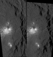
|
Posted by: MizarKey Aug 5 2016, 04:39 PM
http://www.nasa.gov/mission_pages/dawn/main/multimedia/images/
i am getting a 404
I don't know if it replaced the image of the day page, but here's the link to the dawn images > http://www.nasa.gov/mission_pages/dawn/images/index.html
Posted by: Julius Aug 9 2016, 09:19 AM
It's interesting to note that the Galilean moons Ganymede and Callisto also show clay minerals on the surface like Ceres. Can anyone elaborate on this?
Posted by: dvandorn Aug 10 2016, 07:57 PM
The presence of clays implies rock altered in an aqueous environment. With proposed subsurface liquid water deposits, either ancient or current, within each of these bodies, I am thinking it's not difficult to understand how such clays form. How they got to the surface, that's another matter, though I imagine impacts have had something to do with it...
-the other Doug
Posted by: charborob Aug 11 2016, 04:12 PM
LAMO images 146 and 147 stitched together:
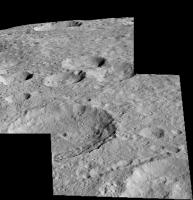
|
Posted by: Don1 Aug 27 2016, 08:51 AM
From GSA meeting abstracts:
"CERES EVOLUTION BEFORE AND AFTER DAWN"
" In this new study we propose one possibility is that Ceres accreted as an ice and silicate mixture after short-lived radionuclides in CAIs had significantly decayed, i.e. nearer 5 my after CAIs, and thus differentiated less completely than for hotter models. On the other hand, the presence of heavily aqueously altered mineralogies, including probably salts, suggests extensive mixing of water and silicates, which might normally be associated with more complete differentiation. Geologically recent activity, perhaps even to the present time, seems evident from several young landforms, including protrusions consistent with diapirism and recent exposures of water ice...The presence of ammoniated minerals and what appear to be salt deposits suggest a major lowering of subsurface water ice melting temperature,."
"SURFICIAL COMPOSITION OF DWARF PLANET CERES"
"... presence on the surface of a mixture of dark carbon-rich minerals, Mg- phyllosilicates, ammoniated clays, and carbonates [4]...[bright spots] are mostly consistent with a large amount of carbonate, implying recent hydrothermal activity "
My comment: A recently active hydrothermal site would be a nice place to visit with a lander!
"ELEMENTAL CONSTRAINTS ON CERES' EVOLUTION"
"[Gamma ray spectrometer] data show that Ceres regolith is hydrogen rich, with an equatorial composition (Fe, K, C) similar to that of aqueously altered CI/CM chondrites."
My comment: The famous Murchison meteorite is a CM chondrite.
Posted by: Explorer1 Sep 1 2016, 06:36 PM
Looks like Ahuna may be volcanic after all! A tenuous, temporary atmosphere was detected as well.
http://www.jpl.nasa.gov/news/news.php?feature=6611
Posted by: Daniele_bianchino_Italy Sep 1 2016, 08:18 PM
Now that we know the composite and internal structure of ceres, we can exclude a possible liquid salt water layer under its surface?
Posted by: Gladstoner Sep 2 2016, 07:48 PM
Evidence of water found in Oxo Crater:
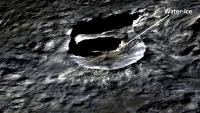
|
http://photojournal.jpl.nasa.gov/catalog/PIA20916
The indicated area of water-ice detection appears to be near the toe of the massive wall slump. Example of a rotational slump:
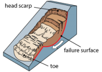
|
Perhaps the ice was recently brought to the surface by the slump movement. If so, this could indicate the presence of ice just below the surface in many areas (that hasn't yet sublimated due to long exposure).
Posted by: Daniele_bianchino_Italy Sep 24 2016, 08:05 AM
?
Posted by: nprev Sep 24 2016, 05:53 PM
Danielle, to my knowledge there have been no conclusions published in peer-reviewed scientific journals to that effect one way or another. Certainly no authoritative opinions concerning that or any other attribute of Ceres (or any other body) are to be derived from our discussions here. UMSF is not a peer-reviewed scientific journal.
Posted by: Gladstoner Sep 26 2016, 06:12 PM
The short and general answer is probably no. There is likely a diffuse 'wet' zone between the surface regolith (and underlying megaregolith?) and the denser lower mantle and core. The water probably occupies pore spaces between grains and along structural breaks such as fractures. Roughly speaking, this could be thought of as a liquid salt water layer. On the other hand, the lack of isostatic adjustment of surface features and the extensive presence of 'rocky' material at the surface seem to preclude or severely restrict the presence of any 'free standing' layer of water, brine, or ice.
Posted by: Daniele_bianchino_Italy Sep 27 2016, 09:15 AM
I know, but here they write people very competent, in a scientific manner; and realistic. Certainly, they are waiting 'public conclusions. In this Forum, there is little imagination, and a lot of reality ', and I like this;
Many thanks
Many Thanks for your opinion 'Gladstone'
Posted by: JohnVV Sep 30 2016, 01:49 AM
"And now for something completely different ..."
it has been a bit since i did a 3d rendering of a crater on Ceres
release #170 "PIA20932"
http://photojournal.jpl.nasa.gov/catalog/PIA20932
http://imgbox.com/hMZT2ICD
http://imgbox.com/kXh3a71Z http://imgbox.com/KobsN4Gc http://imgbox.com/swLukDYy http://imgbox.com/z0Hrv8ww
--
http://imgbox.com/oooqHusY http://imgbox.com/D0sFCaOC http://imgbox.com/2S92w2hk http://imgbox.com/vNZw4TQE http://imgbox.com/RjqYp6Vx
Posted by: JohnVV Sep 30 2016, 04:19 AM
image release #172 "PIA20934"
http://photojournal.jpl.nasa.gov/catalog/PIA20934
has a nice slump/wasting of a rim
http://imgbox.com/j4o6cxzD
http://imgbox.com/SwP0Zk34 http://imgbox.com/ecq38Jkv http://imgbox.com/7BMzhAv1
Powered by Invision Power Board (http://www.invisionboard.com)
© Invision Power Services (http://www.invisionpower.com)