Mars 3 (Various Topics Merged) |

  |
Mars 3 (Various Topics Merged) |
 Jun 26 2013, 04:28 PM Jun 26 2013, 04:28 PM
Post
#181
|
||
 Member  Group: Members Posts: 215 Joined: 23-October 12 From: Russia Member No.: 6725 |
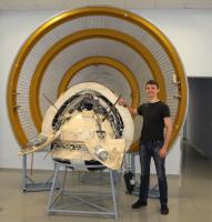
Zelenyikot and Mars 3 in museum of Lavochkin Research and Production Association.

Attached thumbnail(s)
-------------------- My blog on Patreon
|
|
 |
 
|
|
|
Jun 26 2013, 07:34 PM
Post
#182
|
|
 Member Group: Members Posts: 101 Joined: 3-May 12 From: Massachusetts, USA Member No.: 6392 |
That is a good clear photograph, thanks for posting it. Is the spacecraft an engineering model / prototype unit? It looks nicely detailed.
|
|
|
|
|
Jun 26 2013, 10:28 PM
Post
#183
|
|||
|
Member Group: Members Posts: 215 Joined: 23-October 12 From: Russia Member No.: 6725 |
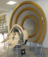
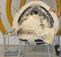
Yes, it is the full-scale model.
Attached thumbnail(s)
-------------------- My blog on Patreon
|
||
|
|
|
||
|
Aug 5 2013, 11:39 PM
Post
#184
|
|
|
Solar System Cartographer Group: Members Posts: 10146 Joined: 5-April 05 From: Canada Member No.: 227 |
The IAU has just named three craters (two very small) near the Mars 3 site after towns, two in Russia, one near the Mars 3 launch site. The latter, Tyuratam, is probably the most well-known name.
Phil http://astrogeology.usgs.gov/HotTopics/ind...rs-on-Mars.html -------------------- ... because the Solar System ain't gonna map itself.
Also to be found posting similar content on https://mastodon.social/@PhilStooke NOTE: everything created by me which I post on UMSF is considered to be in the public domain (NOT CC, public domain) |
|
|
|
| Guest_alex_k_* |
Oct 16 2014, 03:01 PM
Post
#185
|
|||
|
Guests |
Hi everybody.
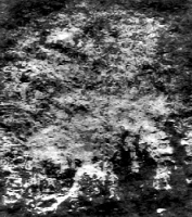
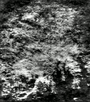
I try to solve the puzzle of Mars 3 images - what did the spacecraft really send to us. The orbital image of "mountains" was taken from the perfect Don P. Mitchell's site http://mentallandscape.com/C_CatalogMars.htm 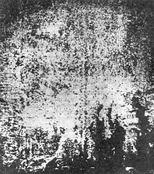 After processing I got the follows:
I suppose that there're Argyre plantia and crater Galle - the corresponding place found at Google Mars:
Does it seem correct? Alex |
|||
|
|
|
|||
|
Oct 16 2014, 03:47 PM
Post
#186
|
||
|
Solar System Cartographer Group: Members Posts: 10146 Joined: 5-April 05 From: Canada Member No.: 227 |
This was my interpretation:
Phil -------------------- ... because the Solar System ain't gonna map itself.
Also to be found posting similar content on https://mastodon.social/@PhilStooke NOTE: everything created by me which I post on UMSF is considered to be in the public domain (NOT CC, public domain) |
|
|
|
|
|
|
Oct 16 2014, 11:05 PM
Post
#187
|
||
 Interplanetary Dumpster Diver Group: Admin Posts: 4404 Joined: 17-February 04 From: Powell, TN Member No.: 33 |
This is my interpretation, although this is from a scan, not from Don Mitchell. I was never certain whether the dark corner was the limb, a dark area, or a bad spot.
 Here is a version I processed without the assumption that this corner is sky.
-------------------- |
|
|
|
|
|
| Guest_alex_k_* |
Oct 17 2014, 05:52 AM
Post
#188
|
|
|
Guests |
QUOTE (Phil Stooke @ Oct 16 2014, 08:47 PM)  This was my interpretation:
Phil Hi Phil, Your interpretation looks good. The big structures seems very similar to the Mars 3 image. But there are two uncertainties: 1. I tried to compare your interpretatin with modern maps (layers of Google Mars) but I can't find match in details. 2. I think the orbital images were published in proper orientation, so reflecting seems unnecessary. It's a really difficult question - what deformations were in the signals of Mars 3 and what information about them was known. Orbital data were much less deformated than the signal from the lander, so I think they were decoded properly. It would interesting be to confirm (or reject) my interpretation by using a model of Mars with detailed altitude map. If to find the place in the proper perspective and to put the Sun low over the horizon on south-east (upper side of the image), we should get a very close picture. Alex |
|
|
|
|
|
| Guest_alex_k_* |
Oct 17 2014, 06:03 AM
Post
#189
|
|
Guests |
QUOTE (tedstryk @ Oct 17 2014, 04:05 AM) This is my interpretation, although this is from a scan, not from Don Mitchell. Hi Ted, Your site http://www.strykfoto.org/mars3.htm is great, thanks. In my processings of Mars 3 images I didn't use any smooth noise reduction methods - using them we can lose important information covered in the deformated signals, mostly about details. Instead of that my main method was a transformation of Fourier spectrum of the image - the images seems to have very reduced low frequencies, and I intensified them. For Mars 3 images that gets very strong effect. Ted, do you really have quality scans of the original signals? I'm very interested in the quality source of the data received from the lander. Is it possible to share them? I'll share my result of processing the lander's singnal, but it is not certain enough because of use of Internet sources. Alex |
|
|
|
|
Oct 17 2014, 07:54 AM
Post
#190
|
|
|
Member Group: Members Posts: 378 Joined: 21-April 05 From: Portugal Member No.: 347 |
Without knowing the image geometry (specially the field of view) it's hard to find candidates. There's the possibility that the image is flipped horizontally or vertically.
But a good guess it that the Mars 3 image should look like the Mars 4/5 images transmitted in low resolution (also on Don's site). Some Mars 4 / 5 images had "reseaux" marks, and t I don't see them here. So perhaps the image is too degraded to show a useful image (only noise). -------------------- _______________________
www.astrosurf.com/nunes |
|
|
|
|
Oct 17 2014, 10:23 AM
Post
#191
|
||
|
Interplanetary Dumpster Diver Group: Admin Posts: 4404 Joined: 17-February 04 From: Powell, TN Member No.: 33 |
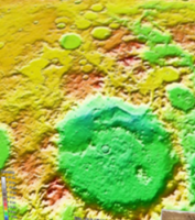
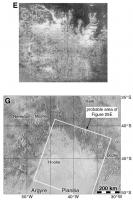
I'll have to dig. I worked with this one many hard drives ago. I will say this. These images only had 250 lines. And it is incredibly noisy. And, frankly, even on the original journal page, it looked like it might have been photocopied. So without trying to clean it, Fourier transformation is just going to enhance noise. At any rate, in my version it is easier to see the outline of the crater Hooke as well is the albedo features at the bottom. Phil's location is correct.
4th rock, yes, Mars 3 had reseau, which can be seen in the attached image. I'm not sure the image in question isn't too degraded to see it.
-------------------- |
|
|
|
|
|
| Guest_alex_k_* |
Oct 17 2014, 11:59 AM
Post
#192
|
|
Guests |
QUOTE (4th rock from the sun @ Oct 17 2014, 12:54 PM) Without knowing the image geometry (specially the field of view) it's hard to find candidates. There's the possibility that the image is flipped horizontally or vertically. But a good guess it that the Mars 3 image should look like the Mars 4/5 images transmitted in low resolution (also on Don's site). Some Mars 4 / 5 images had "reseaux" marks, and t I don't see them here. So perhaps the image is too degraded to show a useful image (only noise). Mars 3 had two cameras: "Zufar" with focus 350mm and angle of view 5.67deg and "Vega" with focus 52mm and ange of view 35.7deg. Mars 4/5 had advanced versions of the cameras. Probably two Mars 3 orbital images were made by 52mm camera. But Mars 3 had very elliptical orbit ~1000 x 200000km so the images should be very different. I suppose that the degradation of images at most caused by problems with communication equipment which deformated frequency structure of the signals. And perhaps the information can be extracted by proper processing. QUOTE (tedstryk @ Oct 17 2014, 03:23 PM) So without trying to clean it, Fourier transformation is just going to enhance noise. It depends on structure of signal, noise and on kind of applying Fourier transformation. I agree that images look like they were photocopied. But it doesn't mean they actually were. QUOTE (tedstryk @ Oct 17 2014, 03:23 PM) the albedo features at the bottom. At the bottom I suppose we see long shadows covering some details on the surface and highlighing others. A sunrise. |
|
|
|
| Guest_alex_k_* |
Oct 17 2014, 12:06 PM
Post
#193
|
|
|
Guests |
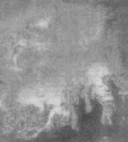
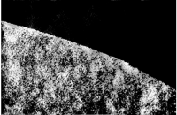
The second orbital image which I tried to locate is "Atmospheric Edge", also from Don Mitchell's site
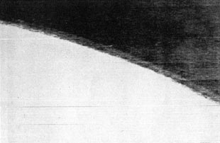 After contrast enhancement and debluring (1): [attachment=33995:res_C_Ma...sphere_X.jpg] After applying Fourier transformation (2): [attachment=33996:res_atm.png] Contrast processing again (3):
The image is actually very noised. After the step 2 probably we see regular noise, which replicates "ground" to the "sky" even twice. The Fourier transormation indeed enhanced it, like valuable details. My interpretation. The "channels" on the left of the picture hint that it's somewhere near Olympus Mons. |
|
|
|
|
|
|
Oct 17 2014, 04:36 PM
Post
#194
|
|
|
Solar System Cartographer Group: Members Posts: 10146 Joined: 5-April 05 From: Canada Member No.: 227 |
OK, two points. First, there is absolutely no geographical information in that image, and you can't use it to identify a surface location. All that texture is spurious.
Second, there were only three periapsis data-taking sequences, and maps of their locations have been published. One passes across Argyre, one just west of Hellas and one over Hesperia Planum (http://publish.uwo.ca/~pjstooke/marsatlas6.jpg) The resolution of the haze layer shows this is a low altitude image so it has to be over one of those areas, and can't be over Olympus Mons. Phil -------------------- ... because the Solar System ain't gonna map itself.
Also to be found posting similar content on https://mastodon.social/@PhilStooke NOTE: everything created by me which I post on UMSF is considered to be in the public domain (NOT CC, public domain) |
|
|
|
|
Oct 18 2014, 02:17 AM
Post
#195
|
|
|
Member Group: Members Posts: 378 Joined: 21-April 05 From: Portugal Member No.: 347 |
All that processing to the 2nd image only reveals the texture of the paper upon the image was printed
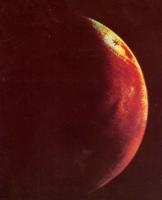
 The fact that you are able to generate detail from a featureless image (it's overexposed) shows the danger of overworking the data. I agree with Phil's interpretation of the equatorial image. It's consistent with a photo of albedo features, probably with bright dust clouds covering the lower parts of the surface. That would give you higher contrast and some topographic effect without the need for shadows. The Mariner 9 images show just that: 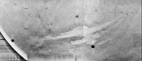 It's obvious that, on this case, it's Vallis Marineris, although it looks like a negative image. -------------------- _______________________
www.astrosurf.com/nunes |
|
|
|
|

|
Lo-Fi Version | Time is now: 20th April 2024 - 01:59 AM |
|
RULES AND GUIDELINES Please read the Forum Rules and Guidelines before posting. IMAGE COPYRIGHT |
OPINIONS AND MODERATION Opinions expressed on UnmannedSpaceflight.com are those of the individual posters and do not necessarily reflect the opinions of UnmannedSpaceflight.com or The Planetary Society. The all-volunteer UnmannedSpaceflight.com moderation team is wholly independent of The Planetary Society. The Planetary Society has no influence over decisions made by the UnmannedSpaceflight.com moderators. |
SUPPORT THE FORUM Unmannedspaceflight.com is funded by the Planetary Society. Please consider supporting our work and many other projects by donating to the Society or becoming a member. |
|