Printable Version of Topic
Click here to view this topic in its original format
Unmanned Spaceflight.com _ Past and Future _ Mars 3 (Various Topics Merged)
Posted by: tedstryk Dec 29 2004, 10:36 PM
On my website sometime back, I added a page on the image fragment sent back by the Mars-3 Lander. I released serveral versions, including the best quality processing using othodox techniques I would use on other images plus colorization here:
http://pages.preferred.com/%7Etedstryk/fragmentc.jpg
However, I released another image, which I called a "What if" image. This image can be seen here http://pages.preferred.com/%7Etedstryk/m3s5b.jpg It was produced via extreme processing of the original data to make a Mars-like scene, but I made it clear on my website it was only a speculative image. I strongly doubt if the raw data even shows Mars at all - it could be all noise. But since this mode of processing looked strangely Viking-like, I figured I would put it on the web. I was warned by several, who said that while fun, some kooks might take it seriously. My response was that I really don't care what kooks think. Then I noticed this web page:
http://en.wikipedia.org/wiki/Mars_2
They used the overprocessed image. I feel like it is being presented as a true photograph. This is of concern.
Posted by: lyford Dec 29 2004, 11:09 PM
Since it's Wikipedia, can't you just delete or edit it yourself?
But I guess the genie is out of the bottle, so to speak.... 
BTW, I really appreciate your work on your website. Thanks!
Posted by: tedstryk Dec 30 2004, 01:12 AM
Thanks. I will be updating the Phobos-2 section soon. I have some reprocessed Thermoscan stuff about ready to go up.
As for the Wikipedia problem, I have been able to edit the caption one sees when one clicks on the image. However, it won't let me edit the caption under the image on the original page. But at least I did get a disclamer in. It is neat to speculate that this might be a glimpse of Mars, but it most likely is just noise. I don't want people to come to a different conclusion based on this image, which, as I said, is very much overprocessed. It is, as I said, an experiment in the area of "what if"
Posted by: PhilHorzempa Apr 18 2006, 10:02 PM
[size=2]
With regard to the Soviet Mars landers, I now think that they may have
been "done-in" by the lowdensity Martian atmosphere. Perhaps, the three
Soviet probes that did land on Mars came closer to success than may have
been earlier believed. The recent realization that low density during the
EDL of Spirit may have brought that mission to a sad end has caused me to
reconsider other missions, such as Beagle 2, the MPL and the Soviet Mars 2,
Mars 3 and Mars 6 landers.
It appears that the Mars 2 qnd 3 landers were notdesigned to communicate
back to the Earth until after landing, much like the Mars Polar Lander. If this
is true, then perhaps Mars 2 didn't simply "plow into" Mars as is popularly believed.
Perhaps, its EDL sequence was executed, but low density Martian atmospheric
conditions caused it to be damaged upon landing. The same may be true for
Mars 3 and Mars 6.
In addition, it appears that the Soiets modified Mars 6 so that it did transmit
during EDL as it radioed back data on Martian atmospheric composition (which
threw a scare into the Viking mission sceince team).
I would be interested in the thoughts of others in the UMSF community and
in any additional info that they may have on the Soviet missions.
Another Phil
Posted by: BruceMoomaw Apr 18 2006, 10:18 PM
The Soviets actually do firmly know why Mars 2 failed, as V.G. Perminov said in his interesting historical document "The Difficult Road to Mars". They didn't trust the accuracy of their radio tracking network, so they incorporated an optical guidance system into the Mars 2 and 3 orbiters to allow them to calculate the optimal course for their final pre-arrival midcourse correction. Unfortunately, the Soviets had slightly inaccurate data on Mars' ephermeris, and so -- while Mars 2's onboard system worked as planned -- it ended up putting its lander onto a course directed at too steep an entry angle, which would have led to the lander crashing in any case before its parachute could properly brake it.
The Bad Luck Fairy that has always haunted the Russian Mars program struck in a particularly brutal way that time. First, the next year the US (as part of a planetary science data exchange program) provided the Soviets with a corrected Martian ephemeris -- and, second, it turned out afterwards that if the onboard optical system HADN'T made that correction, Mars 2's preexisting approach trajectory would, by pure luck, have put the lander on a properly shallow entry!
The failures of the Mars 3 and 6 landers remain more mysterious. Perminov expresses his suspicion that Mars 3 might perhaps have been knocked out by an electrostatic discharge from the giant dust storm it landed in. As for Mars 6, it failed at about the time its final solid-fueled braking rocket was supposed to fire -- meaning that the rocket could have fired at an inappropriate time due to Martian conditions, failed to fire at all, or exploded.
Posted by: tedstryk Apr 18 2006, 10:41 PM

It is thought that it probably fired too late...in other words, it was too close to the surface when it fired, so it was still going too fast when it hit. It is because the timing was a bit off. Still, the fact that the timing was as close as it was is remarkable, given that, due to computer problems, Mars-6 had been unable to receive ground commands for five or six months at this point! It was purely operating on pre-programed sequences. In fact, the Russians were expecting this, although they were hoping for a stroke of luck, because they realized, as it approached and the trajectory was refined, that this was a problem, but, since Mars-6 couldn't be commanded, they were helpless to do anything about it.
However, the failure of Mars 4/5/6/7 was really not bad luck. It was bad microchips (which is what made Mars 6 uncontrollable, Mars 7 miss the planet, Mars 5 depressurize, and Mars 4 unable to fire its breaking motors). The scientists and engineers knew it and wanted to delay the mission until the next window to replace them, but since there was a chance that, as Mars-6 came very close to doing, they still might last just long enough to arrive and touch down for a brief surface mission to get the "first," the political powers ordered them to proceed with launch. They were going to try again in 1975 with a similar lander with good microchips, which may well have suceeded, but since Viking was much more capable (although it would have had some experiments that Viking didn't), and the Soviets had already made it to Venus, once it was clear that Viking would launch in the 1975 window, they mission was cancelled. Had Viking been delayed, it would have launched.
Posted by: BruceMoomaw Apr 19 2006, 02:49 PM
Oh, yes, Perminov goes into great detail about the lousy microchips (due to a decision made by one lower-level manager to cut costs by manufacturing them using aluminum instead of gold). However, it's doubtful that a "timing error" was the problem, because the ignition moment for the braking rocket on the Soviet landers (as for our own three rough Mars landers) was supposed to be triggered by a radar altimeter -- one could hardly depend on a preset timer for it. Of course, the microchips could very easily have fouled that up. (Or, of course, given what we now know about the atmosphere-related dangers of Mars landings, it could have been a simple wind gust or lower-than-normal upper air density than ruined Mars 6.)
As for their instrumentation (on which Perminov also provides useful data), the only instruments they carried that were not on the Vikings were the penetrometer and gamma-ray densitometer on that tiny tethered matchbox-sized "rover" they carried. The other instruments were two facsimile cameras, weather sensors, an atmospheric mass spectrometer, and an X-ray spectrometer for soil analysis on a boom fastened to one petal tip. No life-related experiments at all, but of course the additional surface geological data they could have provided would have been useful.
Posted by: The Messenger Apr 19 2006, 03:59 PM
The Bad Luck Fairy that has always haunted the Russian Mars program struck in a particularly brutal way that time. First, the next year the US (as part of a planetary science data exchange program) provided the Soviets with a corrected Martian ephemeris -- and, second, it turned out afterwards that if the onboard optical system HADN'T made that correction, Mars 2's preexisting approach trajectory would, by pure luck, have put the lander on a properly shallow entry!
The failures of the Mars 3 and 6 landers remain more mysterious. Perminov expresses his suspicion that Mars 3 might perhaps have been knocked out by an electrostatic discharge from the giant dust storm it landed in...
This is a discussion we should have been having two years ago, right after the MER's descended more rapidly than expected...and it would be helpful if complete engineering Doppler and accelerometer data would be made public so that we can work the problem. Sheeesh.
Perminov's speculation that Mars 3 suffered a static incident is just that: He pointed out probes entering the Venician atmosphere snap crackled and popped, but he has no data from Mars to support this guess. We have had two probes scurrying around Mars for two years now without a single mention of a static event, making Perminovs theory even more suspect. (Spirit and Opportunity didnt even experience plasma blackouts.)
Likewise, blaming the Mars 2 failure on both a bad ephemeris and a bad self-correction is a little like insisting the failures of both Beagle and the Polar Lander were absolutely caused by bad engineering, now that another likely suspect has emerged.
There have been a lot of hints something isnt right in earlier missions: Both Viking craft experienced accelerations that indicate an over performance of the parachutes, while the Pathfinder EDL indicated an under performance of the same design. I think both characterizations are in error: The Pathfinder did not contain accelerometers, relying on Doppler, while Viking did not have Doppler, but did have accelerometers. If you run the numbers, it is easy to see how in both cases greater acceleration than expected would end up as puzzling drag coefficients. Too many degrees of freedom! More sensors needed!
It is no secret my own bias towards an exceptional solution skews my interpretations of these events, but until we have all the facts on the table, it is difficult to judge which of the many possible scenerios have led to so many failures. PhilHorzempas correct; a reevaluation is in order, and for heavens sake lets figure out how to properly characterize the atmosphere!
Posted by: mcaplinger Apr 19 2006, 04:20 PM
Have you actually looked at the data that have been released to assess their adequacy? The pre-entry state of the MERs, which is what people have complained about, are on the NAIF FTP site, I believe. All of the raw data appears to be out there to do whatever EDL reconstruction you want; I don't think that the MR doppler tracking is actually useful for the reconstruction, but I believe it was archived with the MOC PDS releases quite a while back.
Posted by: PhilHorzempa Apr 19 2006, 04:53 PM
[size=2]
This discussion is very relevant to future Mars landers such as Phoenix and MSL.
I have heard that significant funding ( about $20 million?) was added to the Phoenix
project in response to results from the MERs' EDL. Other than that cryptic info,
there has been silence about this from the Phoenix team. In fact, in an exchange of
emails with one of the Phoenix team, I learned that they are convinced that the MPL was
desroyed by the famous software bug that the Mishap Board uncovered.
The software reset error on the Polar Lander is a good suspect. However, I worry
that, with a suspect in hand, the other risks are being ignored. To me, the biggest
risks are this uncertainty in Martian atmospheric density and the unexplained
oscillations experienced by the ME Rovers.
I agree with TheMessenger that we need to adequately instrument ALL future
landing missions. Also, NASA should be more open about this issue and open
to assistance from the UMSF community.
Does anyone have insight into what, if anything, the Phoenix and MSL teams
are doing to deal with this landing risk?
Posted by: tasp Apr 19 2006, 05:51 PM
Sorry I can't cite a reference for this, but it seemed I read somewhere the electrical effects noted during Venusian atmospheric descent were thought due to various compounds and elements in the atmosphere condensing onto the relatively colder external surfaces of all the Venus probes. Local precipitation if you will.
If this be the case, would there be a similar mechanism for Mars?
(other than aerostatic charging as a result of friction with the Martian air)
Posted by: The Messenger Apr 19 2006, 05:56 PM
Yes and no. I have made inquires, and been told the engineering data is not going to be made publicly available.
All of the raw data appears to be out there to do whatever EDL reconstruction you want; I don't think that the MR doppler tracking is actually useful for the reconstruction, but I believe it was archived with the MOC PDS releases quite a while back.
Paul Withers wrote in an MER EDL paper he has submitted to Icarus, that he had to make a lot of approximations concerning initial conditions - perhaps the needed information is available now at the NAIF FTP site...whatever and where ever that is. If it is where I have been looking before, there are a lot of 'expected' tables, but the "reconstructed" or actual descent data is just not there. Paul emailed to me that he thought some of the data is ITAR restricted, but I don't see why. He also said that a well-funded study of the MER EDLs - comparable to earlier missions, is not 'in the budget' - I assumed he meant NASA isn't really taking these things apart, but I have been wrong before.
I've been raising my hand and holler'n that I think I can see a stunning trend for a year-and-a-half now. It is hard to get attention when so few people seem to know that the MERs almost splatted - Pathfinder too. As far as I know this is the first really public admission the missions were in jeopardy:
At least now I can go to my congressman and tell him why we need to fund more Mars science before we can even dream of going there, because something is not well understood.
Posted by: ljk4-1 Apr 19 2006, 06:01 PM
Two very relevant documents to this thread online:
The Difficult Road to Mars: A Brief History of Mars Exploration in the Soviet Union
http://klabs.org/richcontent/Reports/mars/difficult_road_to_mars.pdf
Soviet Veneras and Mars: first entry probes trajectory reconstruction and science
http://trs-new.jpl.nasa.gov/dspace/bitstream/2014/37338/1/03-2619.pdf
Posted by: tasp Apr 19 2006, 06:06 PM
I realize it will be many years before the Mars 3 site is investigated first hand, but I do hope the team has your enhanced photo with them.
I realize you are qualified to judge the degree of image processing you administered to get the 'Viking' looking result, but, can any amount of processing put consistent shadows on the correct sides of all the boulders in your enhancement? Me thinks there is more than a slight chance you've come up with something significant.
Fun if you 'nailed' it.

Posted by: mcaplinger Apr 19 2006, 06:20 PM
If you're going to make sweeping assertions, it might help to exhibit more cognizance of the process involved. The NAIF FTP site (naif.jpl.nasa.gov) is the standard place where JPL trajectory information is released. The file /pub/naif/MER/kernels/spk/spk_a_c_030610-040104_recon.bsp on that site is, according to its label, "a reconstructed cruise trajectory for MER-A, beginning at TECO and ending at atmospheric entry." There is a similar file for MER-B. If Withers is unaware of those files, you might want to make him aware. If there's something inadequate about the information, I'd be curious as to what.
As previously noted, that state information and the EDL engineering telemetry archive, which has been released and is available on the PDS atmospheric node, are all the information I can think of that would be useful for reconstructing the entries of the MERs.
I'm no apologist for JPL, but carping on this topic would appear to be unjustified.
Now, it may be that what Withers is lacking is a detailed description of the MER aeroshell composition, shape, etc. The design details of reentry vehicles are covered under ITAR for what would seem to be legitimate reasons. I haven't tried to find those details, nor do I know what data precision might be required. There's a fair bit of info in http://library-dspace.larc.nasa.gov/dspace/jsp/handle/2002/11213
Posted by: Phil Stooke Apr 19 2006, 08:12 PM
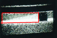
tasp said "can any amount of processing put consistent shadows on the correct sides of all the boulders in your enhancement? Me thinks there is more than a slight chance you've come up with something significant."
I know Ted's perfectly capable of answering this himself - and nobody appreciates his work more than I do - but I want to follow up on this issue.
tasp - don't be misled by the appearance of the image. The bright and dark spots are not boulders and shadows. Ted knows this, I know it, but it's important that everybody knows it. The raw image is a sea of noise. It is just faintly possible that behind the noise is a view of the horizon of Mars, though I don't really think this is true. But the smaller details are just random areas of more or less noise, made to look like landscape features by Ted's careful manipulation. This is a nice image, but it's art. And that's OK.
Phil
Posted by: djellison Apr 19 2006, 08:41 PM
My take on it is - it might be a real picture, and if it is - then this might be what it saw - but we don't really know if it was a proper picture or if it actually saw anything.
Doug
Posted by: tedstryk Apr 19 2006, 10:16 PM
Doug
This is true. That is why I call it a "what if" image. It is the most optimistic processing possible, and then is aesthetically cleaned up. The lower verions on my site are more modest interpretations. Short of finding the original transmission tapes and discovering that modern enhancements can carry the signal out longer, getting more of the image, there will always be mystery around it.
Even if it did see rocks, without a stereo image, some known object for context, or some knowledge of their distance from the lander, it would be impossible to measure their sizes.
I don't mean that the clock wasn't working. It was a problem that resulted in a timing error. Basically, when the engine needed to fire was based on the exact speekd of the spacecraft as well as altitude, and these things were to be determined based on data from the orbiters on approach. Defaults were programmed in case of a situation like this, based on best guesses. Exact trajectory, entry angle, and atmospheric conditions effect the altitude such firings need to be made at. For example, if the atmospheric density was lower than normal, the engine would have to begin firing longer because the lander would need to slow down more, and thus it would have to fire at a higher altitude. There is no way to be sure, but the lack of ability to adapt to conditions certainly could have caused timiing problems.
Posted by: ljk4-1 Apr 20 2006, 12:22 AM
As I recall, the famous Mars 3 image was first shown in the West on
the BBC series The Planets in 1999. Perhaps someone who worked
on the series and obtained the image from the Soviet scientists can
help here?
http://www.bbcshop.com/invt/bbcdvd1003
http://www.bbc.co.uk/science/space/solarsystem/index.shtml
Posted by: BruceMoomaw Apr 20 2006, 01:52 AM
No, the braking engine on all four Soviet Mars landers was (as with our three rough landers) a solid retrorocket fastened to the parachute, triggered by a radar altimeter, and intended to fire for just a few seconds only about 60 meters above the surface -- it had to be riggered entirely by a radar altimeter because (just as with our landers) there was no conceivable way to know in advance exactly what altitude the craft would be at at any given moment.
Posted by: tedstryk Apr 20 2006, 02:35 AM
Atmospheric conditions would have a lot to do with that. But I can see where this is going, so I digress...
Posted by: BruceMoomaw Apr 20 2006, 05:05 AM
Yeah, atmospheric conditions would have a lot to do with how FAST the lander was dropping at the time the altimeter triggered its retrorocket, and could have killed it that way -- and there are of course plenty of ways the faulty microchips could have killed it. But fouling up the precise firing of its retrorocket with a timer malfunction was not one of them. Still, this is something we'll never know the precise cause of, even if some traveller in that antique land someday stumbles across the remains of the lander.
Posted by: The Messenger Apr 21 2006, 03:53 PM
As previously noted, that state information and the EDL engineering telemetry archive, which has been released and is available on the PDS atmospheric node, are all the information I can think of that would be useful for reconstructing the entries of the MERs.
I'm no apologist for JPL, but carping on this topic would appear to be unjustified.
I appreciate the help, but I am not the only one who is finding it difficult to chase down relevant data:
http://nesc.larc.nasa.gov/admin/documents/RP-04-10_MER_Position_Paper.pdf
Recommendation: The EDL technical processes, as well as the processes and schedules for required output products and key decisions, should be well documented in a form that is usable by independent experts.
I'm still trying to figure out how close the actual landing times of both MERs were to the expected atmospheric descent - relative to the time of entry: How fast did these puppies fall?
Posted by: mcaplinger Apr 21 2006, 04:28 PM
http://nesc.larc.nasa.gov/admin/documents/RP-04-10_MER_Position_Paper.pdf
This is primarily a human factors study, and while it has some interesting tidbits, the notion you seem to be dancing around, that there's some big conspiracy of silence surrounding the MER EDLs, is simply not supported by the evidence.
http://techreports.larc.nasa.gov/ltrs/PDF/2004/aiaa/NASA-aiaa-2004-5092.pdf -- the "reconstruction" column in tables 3 and 4 seems pretty clear to me. The MER-A RAD firing was 339.4 seconds from entry; the expected 3DOF Monte Carlo range was 317.3-376.2 sec. The MER-B RAD firing was 336.3 seconds from entry; expected 3DOF was 317.1-372.2 seconds.
I'll leave it to Doug to move this discussion to the MER area; it's clearly pretty far off topic here.
Posted by: ljk4-1 May 1 2006, 04:01 PM
This company (which I have no involvement with) is selling an actual
small model of Mars 3 in orbit around its namesake.
See here:
http://apollomaniacs.web.infoseek.co.jp/apollo/model/startales2/startales2b_05.jpg
Posted by: Bob Shaw May 1 2006, 05:08 PM
small model of Mars 3 in orbit around its namesake.
Try searching eBay for StarTales and you'll find *lots* of lovely little Japanese 'Candy' models like this - Viking Lander, Lunokhod, Voyager, Sputnik, Ranger to name but a few!
Bob Shaw
Posted by: tedstryk May 1 2006, 08:28 PM
I have one, and am quite fond of it 
Posted by: vikingmars May 2 2006, 08:37 AM
When I was working on Russian planetary data at Brown University in 1984, Russian scientists told me that (i) the Mars 3 "image" is a strip that should be seen vertically and NOT horizontally, (ii) in the 20 seconds of data, NO contrast was transmitted : it was just a kind of "carrier"...
Sorry, but as Ted said, NO real imaging data there. The Viking landers were the 1st spacecrafts which succeeded in taking images from the surface of Mars...
Posted by: tedstryk May 2 2006, 09:32 AM
Sorry, but as Ted said, NO real imaging data there. The Viking landers were the 1st spacecrafts which succeeded in taking images from the surface of Mars...
In my talks with a few Russians, they have contradicted each other on that...some they it is the very beginning of a scan, others do not. The other issue is orientation...Our understanding of the orientation of the "horizon" line, or even where the horizon should be, could be way off, because we don't know the orientation of the craft, given the possibility that the lander didn't fully open up or tipped over, etc.
Posted by: djellison May 2 2006, 09:59 AM
Might it be a vertically oriented image, but with a cover or piece of structure blocking the first part thus giving the illusion of a horizon?
Doug
Posted by: tedstryk May 2 2006, 10:23 AM
Doug
All these things are possible. Part of the problem, coupled with the small size, is the amount of noise. And, if one explaination I have heard, that being that it is some sort of prescan, it may be significantly horizontally compressed. The only possible ways to resolve what happened to Mars-3 are a) send and astronaut or rover to examine it (this will not happen any time soon, but perhaps, if it is something obvious enough, an eagle-eyed orbiter will spot it) or
 if the original transmission tapes still exist, and they probably don't, use modern techniques to see if anything can be pulled from the noise beyond the 20 seconds.
Posted by: 4th rock from the sun May 2 2006, 01:44 PM
Doug
If I'm not mistaken, the image was scanned using vertical lines, and from left to right, the same as with the other russian probes (Luna, Venera, etc), right? So the Mars 3 image we see coming out of the printer is in fact rotated 90º.
Now the issue is to know the direction of the scanning: was it up->down? or down->up in each line?
Not knowing this, my judgement is that we are seeing a vertical image, horizontally compressed and perhaps with a flipped scaning direction. This can explain why the "sky" looks darker than the "horizon". The image might be is reversed ;-).
Here's my guess at the original image correct orientation:
|
White area at left is the start of the scan, with some sort of autogain feature going down until the image is correctely exposed.
And a processed version (just geometrical correction, rotation to the right and some noise reduction):

Posted by: vikingmars May 3 2006, 08:57 AM
Assuming that this is indeed a compressed vertical scan of a panoramic section : here is the 20:1 stretch with a quick contrast balance. If the atmosphere was still filled-up with dust (high opacity) the darkening of the atmosphere near the "horizon" is consistent with what was observed from VL1 (link herebelow to VL1 images before and during a dust storm)http://www.unmannedspaceflight.com/index.php?s=&showtopic=1556&view=findpost&p=23875
|
|
Posted by: 4th rock from the sun May 3 2006, 03:14 PM
Just some data, to make things clearer:
The Mars 3 camera scanned vertically, and each scan line has 500 pixels at maximum.
A full 360º image had 6000 of this vertical lines at full sampling rate (1 line per second, 100 minutes for a full pan).
It's reported that the Mars 3 image was being scaned at 4 lines per second. At this rate, a full 360º pan image would be a 500x1500 pixel image.
Using the reported figure of 79 scanlines receaved from Mars 3 in +-20 seconds, the image corresponds to a field of view of 29º tall by 19º wide !!!
This is the contrary to my previous post, and as such there's not really that much horizontal compression on the original data! So the correct proportions might be something like this:
Posted by: PhilHorzempa May 10 2006, 04:42 AM
I thought that we could try to get the record straight on Mars-96's official
designation on this thread. As I recall (but the memory is hazy), this probe
received the official title Mars 8 since, even though it didn't make it to Mars,
it was launched and did make it into space.
Can anyone confirm this?
If it is true, then perhaps we, on UMSF, should start calling this probe by
its proper name of Mars 8.
Another Phil
Posted by: Phil Stooke May 10 2006, 04:59 PM
I have never heard 'Mars 8' used for that mission. I would be more inclined to think somebody might have said that informally, and that's what you are remembering.
Phil
Posted by: ljk4-1 May 10 2006, 05:23 PM
Phil
I have seen Mars 8 used a few times for Mars 96 (and before delays it was
known as Mars 94), but seeing as the probe never got very far, does it really
matter at this point? It doesn't seem to fit in with the Mars 2-7 series other
than its destination, either.
Mariner 8 would have been called Mariner H had reporters not kept calling it
with an 8 even though it ended up in the Atlantic Ocean. Pioneer E, the last of
the long-lived Pioneer solar probes in the 1960s, would have been Pioneer 10
had it not failed, but reporters weren't as focused on it so it retained the E.
Regarding the Mars 3 image, could the lander take images if it was knocked
on its side? Perhaps the lander came down and tipped over due to the dust
storm winds or some other technical factor or a combination of both.
Posted by: tedstryk May 10 2006, 05:29 PM
Mars '96 would have been Mars 8 if it hadn't been a launch failure. Other Mars spacecraft, such as third orbiter in 1971 which would have beaten Mariner 9, that failed at launch were also never given a number. That is true about the Pioneer series - "Pioneer 10" should have gone to the fifth spacecraft in the Pioneer 6-9 series (they all had letter names pre-launch). Pioneer F and G, the missions we know as Pioneer 10 and 11, would have been 11 and 12, and so on. Since Pioneer E never had a post-launch life, it never became Pioneer 10. And it was the only failure in the Pioneer series since the lettering began with 6. (They didn't count total launch failures in the Pioneer 1-5 series as numbers either, but the two programs of Pioneer 1-2 and 3-5 have nothing to do with the series of 6-13).
Posted by: Zvezdichko Dec 2 2007, 11:58 AM
36 years ago, on this very same day, 2 December 1971, the Soviet probe Mars 3 successfully landed on Mars. Though it functioned for only 20 seconds and no science was returned it was indeed an engineering success.
The first and only picture from Mars 3 lander. Image Credit : Ted Stryk / strykfoto.org
Posted by: Adam Dec 2 2007, 12:12 PM
I might be wrong, but wasn't it pretty much decided that there was little data returned and that the "picture" is only noise?
Posted by: Zvezdichko Dec 2 2007, 12:16 PM
Yes. There have been speculations based on this image,however, that the lander was turned upside down and that line shows the horizon.
I hope that future probes or possibly astronauts will find out that's the reason for the failure
There are some more errr... raw images:

Image of the PropM rover:
Posted by: nprev Dec 2 2007, 01:17 PM
A date & an achievement worth noting to be sure, ZV...and only 14 years after Sputnik I!
Posted by: Zvezdichko Dec 2 2007, 10:33 PM
Yes, only 14 years after Sputnik mankind achieved a soft landing on Mars!
But... it's December already, it's an important month for Martian Exploration.
For example, tomorrow is 3th December. It's the day when Mars Polar Lander had to land, but the contact was lost. Eight years after that, we still don't know what happened to it.
Then... we have 25th December. It was the day when Beagle 2 was supposed to land... It was also lost...
So, we have several probes (Mars 3, MPL, Beagle 2) which were sheduled to land in December, and all failed. Bad statistics...
Posted by: dilo Dec 2 2007, 11:14 PM
Perhaps a little bit OT, but not completely...
Today, when looking to last MER images, I was talking to myself once more: "Is incredible, these beautiful pictures are almost realtime shots from the surface of another planet, and they comes daily in the last 4 years!". Same feeling with Cassini gallery...
I really hope this will continue to be the normality in the future, with a continuous coverage through MSL, EXO-mars and other long-duration missions. Besides scientific return, I think is important to easily access such "alien" visions, it helps us (poor humans) to have a wider breath, avoiding humanity to collapse on herself...
Maybe I'm a dreamer, any though on that?
Posted by: nprev Dec 3 2007, 02:48 AM
You're absolutely right, Dilo...we need to keep looking outward, always. We always have before. That's why we didn't become extinct in some forgotten African valley three or four million years ago...there were always a few rabble-rousers that wanted to see what was beyond the next hill.
If we play it right, it's our immortality...  ...God, how I hope that we do.
Posted by: Shaka Dec 3 2007, 05:20 AM
Good, that makes three dreamers at UMSF.
How many more?
The denizens of Earth need Mars...more than they know.
Posted by: PDP8E Dec 3 2007, 02:56 PM
another more recent thread (36 years on mars) has some reference to the famous Mars 3 image and to Ted's work on that image -etc. (thanks Ted)
My question is there a known 'original' or something that the surrogate original (!?) ...something that isn't a lossy compressed image?
Or am I barking up the wrong tree here.... thanks in advance!
Posted by: tedstryk Dec 3 2007, 05:22 PM
My question is there a known 'original' or something that the surrogate original (!?) ...something that isn't a lossy compressed image?
Or am I barking up the wrong tree here.... thanks in advance!
Well, it isn't lossy in the sense that we think of lossy today (jpegs, etc) - what we have are screenshots. Perhaps the original transmission tapes are somewhere in the Russian archives. It has been so long that even if they are still there somewhere, they may have disintigrated unless there were copies made at some point.
Posted by: peter59 Dec 3 2007, 06:13 PM
EXO-mars' data released daily by ESA ? Are you kidding?
Posted by: dilo Dec 4 2007, 04:28 PM
Hehe, Peter, I understand your sarcasm but I deliberately included EXO-mars in the hope to see a change in the PR ESA policy in the future... at the end, perhaps, it depends also from public opinion pressure!

Posted by: marsbug Dec 4 2007, 04:48 PM
Good, that makes three dreamers at UMSF.
How many more?
The denizens of Earth need Mars...more than they know.
I'd count myself as one more. Although I don't think we should stop at mars
Posted by: PhilCo126 Dec 4 2007, 06:55 PM
Wait one minute, a topic on spacecraft lost around the red planet or on its surface without mentioning the " Great Ghalactic Ghoul ", an imaginary monster living somewhere out around the orbit of the red planet that just likes to destroy spacecraft
This 'absurd' explanation for lost spacecraft was created by Donald Neff, a journalist of TIME magazine 
Posted by: PDP8E Dec 12 2007, 06:57 PM
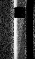
MY SPECULATIVE ANALYSIS OF THE SOVIET MARS 3 LANDER IMAGE
I cropped the probable data portion from the original image.
|
I wrote three C/C++ programs to reduce only image noise:
Eliminate salt and pepper noise with a modified rank order filter
Reduce Gaussian noise with a modified sigma filter
Reduce other noise (speckle and non-Gaussian) via normalization

|
The modifications I made to several well known filter algorithms (Lees sigma filter, the Frost MSE filter, and the rank order filters, -etc.) were done in such a way as to only adjust noisy pixels and to leave the rest of the image untouched. The programs characterized each pixel as either: image or highly probable noise; the programs then assigned the noisy pixels new values depending on their noise type: rank order median for salt and pepper, sigma values or Gaussian, -etc. In the end, over 64% of the final pixels have retained their exact original values. I then wrote another C program to zoom out the image (3x) using the bi-cubic spline interpolation algorithm from the Harley & Weeks image processing handbook.
My Top 4 Interpretations of the Resulting Image

|
(1) Most Probable - (bright horizontal line at the bottom) - Looking down at the ground at something less then 45 degrees, but not under the ship. The dark area is disturbed soil; may be caused by a skidding/rolling type landing. We are looking out less then 2 meters (?). The bright line is a power up artifact of the camera and/or a reflection off one of the unfolded shiny metal shrouds on the lander. This composition is reminiscent of Surveyor, Viking, Venera, and other landers looking at or near their feet as one of their first images.
( no image - just flip the one above)
2) Possible - (flip the image to any of the two vertical orientations) Looking down again at the ground, possibly an out of focus scrape mark from the ship skidding/rolling or just the soil beneath the camera. We are looking down at less than 1 meter (?)

|
(3) Most Wishful - (bright horizontal line at top) Looking out at the horizon with a dark ridge in the foreground notice the rocks in and on the dark foreground ridge... Notice the large rock near the top right near the bright horizon. Notice the rock near the bottom right at the trailing edge of the dark ridge. Notice the rock(s) on the dark ridge near the left edge of the image. Notice the dusty atmosphere near the horizon (at top). We are looking outward from meters to the local horizon (a hundred meters?)
(4) Consensus since the 1970s - This whole image is just noise and my programs and your programs and you and I are just hallucinating, i.e. a Soviet Rorschach test.
Some other points to consider:
- Soviet experts (early 1970s) agreed that this image was just noise.
- The cameras longer axis should be the vertical axis of the image making interpretation 1, 2, and 3, scenes from a craft lying on its side.
- The landing was during a regional/global dust storm
- The available lighting was supposedly 50lux (low lighting)
I interpret the uniformly bright area in the image as the point where the vidicon camera was turned on. It then AGCed within a few lines to a normal gain-level. I suggest this because the noise pixels in the original (un-cropped) image just above this bright area (for ~10 lines before the bright area and parallel to the bright line across the image) are uniformly brighter by a few percent - compared to the noise pixels in all the lines before it; This statistically significant observation suggests the this may be the actual turn-on time of the vidicon; then we see the vidicon blooming (i.e. all signal, no contrast, the white area); and then the gain control takes over .and we have a noisy image for ~60 more lines before the transmission stops. Alternatively, since this brighter noise is spatially correlated to the bright line, it just may be a photographic artifact of the stupid screen-shot that we have been forced to deal with for the last 30+ years. I would really love to get a hold of the original Soviet data!
Final Conjecture:
Mars 3 landed but may have skidded or tipped over during the final approach. The usual suspects are rocks, rockets, chutes, winds, -etc. The damaged lander started its science sequence. The first image was in the process of beaming down to Earth. The orientation of the camera to the noisy image fragment suggests that the lander is not in the upright position. After 70 scan lines reach Earth, the signal is suddenly lost. What failed? Was it the transmitter, the electrical system, the final remnants of the propellant leaking from broken rocket nozzles onto panels and into the system electronics or maybe the battered lander just slouched and started rolling over again as a result of a precarious perch or the slumping soil and rock mechanics from the hard landing
To the MRO Crew:
Please take some lucky MRO images of the Mars 3 landing site for Christmas!
Its easy look in and near northern Ptolemy Crater , 45° S, 158° W; you should see a dusty old parachute and a nearby shiny Soviet lander lying on its side!
Thanks!!
Parting Shot -- A False Color Image of the Wishful Horizon Interp:

|

|
Posted by: Phil Stooke Dec 12 2007, 07:50 PM
"Its easy
look in and near northern Ptolemy Crater , 45° S, 158° W; "
45° S, 158° W (+ or - 200 km or thereabouts).
Phil
Posted by: djellison Dec 12 2007, 08:02 PM
So a 400km x 400km search box. 160,000 sqkm
That's only 2500+ HiRISE images - what's the problem.
Doug
Posted by: PDP8E Dec 14 2007, 03:51 PM
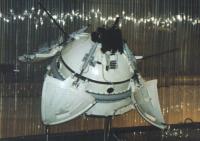
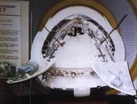
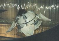
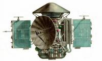
A brief scan of the web turned up these images of the MARS 3 lander in a Moscow Museum
the cameras are on the top (there were two, I believe...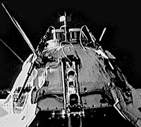
|
|
|
Here is the ship with lander in the aeroshell
|
enjoy comrades!
Posted by: Paolo Dec 15 2007, 08:18 AM
the cameras are on the top (there were two, I believe...
Yes, there were two of them, and the black box visible on top is the amazing PrOP-M walking minirover
Posted by: PhilCo126 Dec 15 2007, 05:54 PM
Thanks for sharing those photos and only the black & white photo shows the arm which deployed the PrOP-M, which was a small tethered rover at the end of an arm on these Soviet-Russian Mars pod landers which were based on the Luna 9 four-petalled opening/righting mechanism!
Posted by: PDP8E Dec 16 2007, 08:36 PM
We have had 8 more inches of snow today on top of the 10 inches from a few days ago...
...so I was shovelling the driveway and heaving snow and then watching it roll down if i didn't get it over the top of the heap...
I am putting a stake in the ground: based on the proximity of all landers to craters and then Oppy actually rolling into one, I speculate that the Mars 3 is tipped over in the bottom a crater. probably not a very deep one, but I conjecture it caught the slope and rolled over to the bottom. The picture I call 'the most probable' would then show the view at the bottom of a crater with undisturbed and disturbed soil (e.g. Oppy's airbag prints, MER tracks in general, -etc). Now if the HiRise guys just listened to my instructions on how to snap a picture of Mars 3, we will all have a wonderful Christmas present 

Posted by: vikingmars Dec 16 2007, 09:34 PM
- Soviet experts (early 1970s) agreed that this image was just noise.
- The cameras longer axis should be the vertical axis of the image making interpretation 1, 2, and 3, scenes from a craft lying on its side.
- The landing was during a regional/global dust storm
- The available lighting was supposedly 50lux (low lighting)
|
|
Dear PDP8 : agreed !
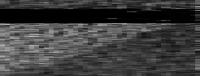
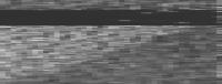
Here are the original "data" in better format + its stretched on its good vertical axis.
The resulting "noise", processed this way, could easily be interpreted as a dark surface seen under a dusty sky with the Sun being hidden by the camera cover just outside the left of the "picture"... If this is indeed an "image"... If the Mars 3 s/c worked well until reaching the surface... If this successful 20 sec data is not Soviet propaganda... Too many "ifs" !!!

|
|
|
Posted by: Geert Jun 6 2008, 07:56 AM
Various sources all seem to confirm that the camera's of the Mars 3 lander scanned vertical lines, moving from left to right, identical to the camera's on Luna 9/13 and on the later Venera landers. So, as has been mentioned here before, the image should be rotated by 90 degrees and the 'horizon' does not make sense unless the craft is lying (almost) on its side.
There is one more interesting description in 'The Difficult Road to Mars' of V.G. Perminov, who describes the receipt of the Mars 3 lander signal on earth: "The transmission of panoramic images of the Martian surface recorded on the magnetic tape was initiated. The main engineer of NII KP, Yu.K.Khodarev, who was standing close to the rack where the signal was displayed, gave a command to reduce the signal because it was too strong. Then, the telephotometer data were transmitted. There was a gray background with no details. In 14.5 seconds, the signal disappeared. The same thing happened with the second telephotometer."
I presume that the "image" we have is in fact the raw teleprint of the signal as received, in which case the quickly darkening after the white area is in fact not an automatic gain control, but a manual adjustment on receipt of the signal. With the image in its correct (vertical) orientation, the whole "horizon" is then also explained as a further manual adjustment of the gain in the hope of getting some picture...
Personally I am still convinced that the whole error was in the relay via the Mars 3 orbiter, and that the lander probably functioned normally and completed its whole preprogrammed surface schedule. Fact is that the lander survived its landing (it had to deploy its pads and antenna after landing in order to start its transmissions, so probably all the basic functions and electronics worked), and from what we now know the duststorm would probably not have had much effect on it, so it is weird that after surviving EDL and starting its surface operations, both transmitters should shut down more or less at the same time.
On the other hand we do know that the Mars 3 orbiter had some serious trouble when braking into Mars orbit. It's engineburn was cut short, resulting in a completely wrong orbit, and it lost 3-axis stabilisation untill one hour after the burn, at which time the lander data was finally transmitted to earth.
With the orbiter not 3-axis stabilised it sounds reasonable that its relay antenna were not pointing to the Mars surface and it lost lock on the lander signal quickly, in which case it is logical that all lander-channels were lost almost at the same time. The 'picture' seems to confirm this, there are black 'gaps' which seem to indicate the signal was lost, then regained, and then lost again, it did not suddenly stop but it faded in and out a few times..
Finally, the lander was pre-programmed for a surface transmission of 25 minutes, where after it would switch to hibernation mode and wait for a signal from the orbiter on its next pass (scheduled 25 hours later) before starting the next transmission. However, the orbiter burned into a completely wrong orbit, with a period of 12 days, and by the time it finally passed over the landing site again, the lander was long dead...
The only 'hope' of ever getting any information from the Mars 3 lander is finding the original tape of the transmission (the one without the manual changes to the gain), if the error was indeed in the orbiter relay due to failure of its attitude-control, then there might be some very faint whisper of the lander somewhere on the tape which was overlooked at the time, and with our modern equipment something might be retrieved from it. But I guess this is overly optimistic...
Posted by: tedstryk Jun 6 2008, 01:50 PM
Two or three minutes into the transmission, the first data transmission (temperature, pressure, etc.) would have come in. If that could be pulled out of a tape, it would be amazing. I seriously doubt that, even if the tapes exist, that anything can be recovered, but it would be cool if it could.
Posted by: aconnell Jun 6 2008, 05:11 PM
Dear Tedstryk. I'd be really grateful if you could re-post your images from the start of this thread as the links seem to have expired - I'm totally intrigued !!!
Posted by: tedstryk Jun 6 2008, 05:46 PM
It was an image I clearly labeled a "what if" image, using highly speculative techniques, basically just playing around. Brian Harvey asked to use it in his book on Soviet planetary probes, he described it with a fabricated tale of it being found in Soviet archives in Moscow after the Soviet collapse. I will never work with him again. I know other contributors to that book feel the same way for this and many other issues. The first one I would still consider a highly processed image, but the second one really (that Harvey claimed was found in the archives) is more of a drawing than a processed image.
|
|
|
|
Posted by: nprev Jun 6 2008, 07:06 PM
I don't know, Ted. They're undeniably fascinating, but it looks so rocky that I'm having a hard time deciding if this is interpolated noise or not...almost looks Gaussian.
Certainly not criticizing you or your efforts, please understand.
Posted by: tedstryk Jun 6 2008, 08:26 PM
nprev, as I said in my description at the beginning of this thread, I think it is most likely just noise. That is why I called it a "what if" image. The only difference between the two images is the level of extreme I took it to....so no offense taken.
Posted by: Geert Jun 7 2008, 08:42 AM
On his excellent site on Soviet Space Cameras ( http://www.mentallandscape.com/V_Cameras.htm#Luna9 ) Don Mitchell shows a pen plotter display of the signal from the Mars 3 lander ( http://www.mentallandscape.com/V_Mars3Signal.jpg ), I suspect this plot is the source of the circulating "Mars 3 image", the true plot (and tape?) must be somewhere hiding in some Russian archive if it still exists.
As explained on above site, the plotter was drawing with horizontal strokes, however the camera was scanning with vertical lines, so the image should be rotated by 90 degrees. As also noted by Perminov, the "picture" was featureless, just a grey background. I seem to remember reading somewhere that there was even doubt whether or not this was the actual video signal, the transmitter was working but the camera itself was not (yet?) online. After only 14.5 seconds the signal from both camera's was lost.
We don't know what happened to the Mars 3 lander, we DO know that the Mars 3 orbiter, who relayed the signal, had serious trouble burning into mars orbit, ending up in a completely wrong orbit (period of 12 days instead of 25 hours) and losing 3 axis stabilization for about one hour, this doesn't sound like a very favorable situation for a data relay and might explain why the signal was lost. The lander was pre-programmed to transmit for 25 minutes, where after it would go into hibernation waiting for a signal from the orbiter on its next orbit, however due to its erroneous orbit the orbiter did not pass the landing site again until the lander battery's were long dead, so they never got a second chance to contact the lander.
Posted by: aconnell Jun 7 2008, 02:09 PM
Many thanks Ted. I can remember as a teenager in the 80s reading about the tantalising 'partial image' from Mars 3. I must have trawled through half the libraries in London to actually see it for myself - without success. I think what your images succinctly articulate is that all too human frailty of seeing what we want to see - transforming a little strip of noise into the first fleeting glimpse of another world. All I can say is thank goodness the Viking landers succeeded not too long afterwards. Can you imagine how iconic this 'image' might have become amongst the conspiracy theorists? The one and only probe to successfully make it to the surface suddenly and mysteriously falls silent. What is it that 'they' do not want us to see? And who are 'they'? Those that built the mighty Face on Mars of course!!!!!!!!!!!!
Posted by: tedstryk Jun 7 2008, 02:26 PM
It is a shame they didn't start the transmission with a temperature/pressure reading or something like that. They would have been able to claim the first data from the Martian surface. Depending on the account, the signal dropped out after 14.5 or 20 seconds. However, the lander had already been on the surface for 90 seconds. That is part of what makes the loss so odd. The Mars-3 orbiter was in a poor position to try to recover it after the initial landing sequence, although it did try. As Geert eluded to, they placed it in a very high orbit that only occasionally brought it near the planet. It was no accident - it had leaked a lot of fuel during cruise, so the planned burn to put it in a shorter orbit was impossible. The fact that they were able to salvage anything is remarkable.
Posted by: Zvezdichko Jun 7 2008, 02:39 PM
Conspiracy theorists are and will always be a lost case. Not only because they're always wrong, but because they don't understand engineering. Now we know a lot of technical information about Mars 2/3 landers, that they have a simpler design than Vikings (Ballistic entry+parachute+solid engines+protective foam) and it indeed works. It only needs to be improved. A good starting point for all organizations and agencies that want to land a probe on Mars.
Posted by: tedstryk Jun 7 2008, 03:02 PM
Well, the Mars-2 and Mars-3 landers are separate cases. Mars-2 was planned using innacurate data about the atmosphere, leading to a suicide trajectory. The only way we will ever know what happened to Mars-3 is the very remote chance that something is recovered off the transmission tapes or the more likely chance that orbital imaging picks it up and gives clues to what might have happened. In the case of Mars-3, the Soviet scientists did try to process the tapes to pull out a signal beyond the time of loss of contact (this worked for Venera-7), but with no luck. I still would love to give modern equipment a crack at it. They indeed had a simpler landing technique. Also, the Vikings are the only planetary landers to have been placed into orbit until an opportune time, after the sites had been surveyed and atmospheric conditions were checked out. A very interesting thing is the Mars'96 penatrator design, which takes the hard lander idea to a new level. The MetNet landers are basically Mars-96 penetrators with improved instruments, so that design isn't dead. The small station design was never built on, but a major reason for that is the fact that the MetNet hard landers can do almost everything that the small stations were going to do and are cheaper, so thanks to improved instrumentation, they are no longer needed.
Posted by: Zvezdichko Jun 7 2008, 03:23 PM
Yeah, MetNet is an elegant decision. However, I'd like to see them traveling aboard Phobos-Grunt rather than launching them separately with a Volna rocket (which will be suicidal for the mission).
Posted by: tedstryk Jun 7 2008, 03:28 PM
Why is that suicidal? The Phobos-Grunt plan was to release the Metnet lander(s?) before entering orbit, so I don't see a difference. The only thing I wish is that they were sending more than one. A badly placed rock could ruin the mission.
Posted by: Zvezdichko Jun 7 2008, 03:35 PM
I personally see Volna as an unreliable vehicle.
Posted by: tedstryk Jun 7 2008, 03:46 PM
Oh, OK, in the sense of possible launch failure. I see what you mean now.
Posted by: Zvezdichko Jun 7 2008, 03:49 PM
Yeah, that's what I meant. Volna failed to launch Cosmos 1 twice. Also we will need a new stage for an interplanetary flight + a cruise stage that has yet to be developed. If MetNet is aboard Phobos-Grunt it won't need it.
Posted by: tedstryk Jun 7 2008, 03:54 PM
My guess is that the little Chinese orbiter took its place on Phobos-Grunt. I would imagine that funding is a major issue. The very existence of the mission owes itself to a way Russia could pay back debt owed to Finland in the late 1990s. At the time, Russia was hat-in-hand, but things have changed, and they may not want to sink more into the mission, given that they could easily afford to just pay Finland now.
Posted by: Zvezdichko Jun 7 2008, 04:02 PM
I understand, but I also don't see how the design of both Metnet and Yinghuo fits in the overall mission. The oldest schemes I posess are from laspace.ru and they are in Russian (no problem for me, I can read it). How are they going to attach the orbiter? Will it be power-independent during the cruise phase? Will it use its own engines for MOI or it will relay on the engines of Phobos-Grunt?
Posted by: tedstryk Jun 7 2008, 04:05 PM
I have those diagrams and have wondered the same thing. My only guess is that it will be released before MOI. Given the huge elliptical orbit Yinghuo is supposed to have, it will probably do its own MOI. I have no idea about power during the cruise phase.
Posted by: Zvezdichko Jun 7 2008, 04:17 PM
You are probably right. The Chinese orbiter will be dedicated mainly to studying the upper atmosphere and the interplanetary medium. It doesn't need to be into a low Martian orbit.
As for Phobos-Grunt I have also some worries. It's more complicated mission that Phobos 1/2 and Soyuz doesn't have the capability of Proton. Does that mean that a most of its systems aboard have no redundancy?
Posted by: tedstryk Jun 7 2008, 06:16 PM
As for Phobos-Grunt I have also some worries. It's more complicated mission that Phobos 1/2 and Soyuz doesn't have the capability of Proton. Does that mean that a most of its systems aboard have no redundancy?
I think a lot of it has to do with the fact that in the post-Soviet era, miniaturization has greatly improved. I still worry. While NASA has a nasty habit of launching missions stripped down to just a few instruments, Russia has a real problem with trying to load every imaginable device onto a probe creating very high levels of complexity (and many opportunities for failure).
Posted by: Zvezdichko Jun 7 2008, 06:41 PM
Yeah, that's why the failure of Mars 96 was really bad. Some of the instruments (HRSC, OMEGA) were reflown aboard Mars Express, others ... well, that's the real loss.
One of the instruments was developed (at least partially) in Bulgaria. It's RADIUS-M. It was supposed to study radiation and if I recall correctly, it's the last Bulgarian scientific instrument which flew aboard an interplanetary mission. I'm sure that another radiation instrument, developed by IKI-BAN will fly aboard Chandrayaan and I hear unofficial rumors that Bulgarian scientists are working with Russian scientists on Phobos-Grunt. Does that mean that they are going to fly once again another radiation dosimeter? I still don't know.
Oh well, here is a link:
http://www.bnr.bg/RadioBulgaria/Emission_English/Theme_Science_And_Nature/Material/April.htm - it says a little, but briefly that a "gauging instrument" will land on Phobos. So, yes, they may refly RADIUS-M.
Posted by: tedstryk Jun 8 2008, 04:34 AM
I hope it makes it on there!
By the way, here is a link to the page in Harvey's book where he makes his claim.
http://books.google.com/books?id=jKmIclMIwPAC&pg=PA146&lpg=PA146&dq=mars-3+transmission+tapes&source=web&ots=E1tYY7GU2a&sig=HqrKAlWe7o4YC3AxTwp5JMp8C54&hl=en
Posted by: Zvezdichko Jun 8 2008, 07:54 AM
Ted, I'm reading the upper link with a great interest. About Mars 6: it says that the photometer took colour filter images of the atmosphere. Do you have some images (as files)? I had once, on a paper and I lost it 
Posted by: tedstryk Jun 8 2008, 12:52 PM
I don't think the Mars-6 flyby module took images. The Mars-4 and Mars-5 craft took pictures with a photometer. Mars-6 had one, but I don't think it was used (I could be wrong). Given Harvey's story about the Mars-3 "image," his book is not a credible source. Here are the Mars 4 and 5 photometer images.
http://www.strykfoto.org/mars4and5.htm
Posted by: Geert Jun 9 2008, 05:12 AM
The Mars-6 lander carried a photometer which was used to measure lightlevels, probably similar to instruments carried on the Venera Venus landers.
Quote: "Contrary to exaggerated press reports, it seems unlikely the instrument was able to return color images" (ref. "Mars 5 and 6 Flight Analysed", Flight International, 4 April 1974 439-440, also ref "Robotic Exploration of the Solar System" Ulivi/Harland, page 167).
I have never seen any reference to pictures taken by the flyby bus of Mars 6 or 7, only pictures taken by Mars 4 and 5 have been published.
Posted by: tedstryk Jun 9 2008, 12:53 PM
Quote: "Contrary to exaggerated press reports, it seems unlikely the instrument was able to return color images" (ref. "Mars 5 and 6 Flight Analysed", Flight International, 4 April 1974 439-440, also ref "Robotic Exploration of the Solar System" Ulivi/Harland, page 167).
I have never seen any reference to pictures taken by the flyby bus of Mars 6 or 7, only pictures taken by Mars 4 and 5 have been published.
I would almost wonder if that reference is to Mars-4 and 5. None of them had color photometers, but instead operated at visible and infrared wavelenths. The film cameras could take color pictures, and Mars-5 returned a few before it failed. Pverkhnosti Marsa is the best reference with regard to this mission.
Posted by: Phil Stooke Feb 5 2009, 12:14 AM
A different story on Mars 2 and Mars 3.
Where did they land and why were those places chosen? I was just plotting the locations on maps of image coverage from previous missions. Mars 2 crashed in Hellas, in the area imaged by Mariner 7. Mars 3 landed right on the southwest corner of Mariner 4 image 13, south of Newton crater. This suggests its target was actually inside the imaged area. The target latitude would be defined by EDL design and the seasons on Mars, and is about 45 south for both missions (incidentally, Wackypedia is waaay off with Mars 2... where did that come from?). It makes a lot of sense for the two mission targets to be in the only areas imaged at that time at that latitude. The site's geological context would be known. And Mariner 7 images seemed to show Hellas was a very smooth plain (actually it was looking at clouds inside the basin), so it would be safe.
So all that looks like it might make sense. But then this can potentially be used to resolve the discrepancy in longitudes between NSSDC and Astronautix.com site locations. Astronautix longitudes are ten degrees larger than NSSDC longitudes. But the Mars 3 site wouldn't be in the image area if the larger longitude value is used.
EDIT - next day - oops, I'm maligning Astronautix, the incorrect location actually came from http://history.nasa.gov/SP-4212/ch9.html (The NASA history volume on Viking). (Possibly the website used that value earlier and has edited it recently)
Any thoughts?
Phil
Posted by: tedstryk Feb 5 2009, 12:39 AM
According to Sasha Basilevsky, Hellas was chosen for exactly the reasons you say (based on a conversation I had with him). As far as Mars-3 goes, I have no clue.
Posted by: Phil Stooke Feb 5 2009, 04:36 AM
Yikes - Google Mars has Mars 2 at the stupid Wikipedia location - it's a travesty ah tells ye!
Phil
Posted by: Geert Feb 6 2009, 09:38 AM
How much certainty do we have on the Mars 2 position. According to most accounts it was released in the wrong orientation (or at least with the wrong coordinates set) after a failure of the mothership to update the lander data. This in turn resulted in a steep dive into the atmosphere and a crash before the parachutes could be deployed. This sounds to me like it went waaay offcourse. Hellas was probably the chosen landingsite for Mars 2, but it might have missed its target by an enormous distance and I doubt if there is much knowledge as to where it eventually crashed...
Given all the uncertainties with ephemeris data at the time and the various coordinate-systems used, I doubt whether any of these probes are anywhere near their stated coordinates.
Posted by: Phil Stooke Feb 6 2009, 11:50 AM
Way off course by a few hundred km maybe, not half way round the planet.
Phil
Posted by: Geert Feb 7 2009, 04:51 AM
I agree on you with that.
I have often wondered how the autonomous navigation prior separation/EDL worked on Mars 2-3. They had quite a big problem due to inaccurate ephemeris data on Mars, that's why they needed an orbiter around Mars prior to both landers, when that launch went wrong they had to rely on the untested autonav function from the landers.
The landers had a solid propellant retro-engine, so their retro-impuls was more or less fixed (they could change the orientation but not the duration of the impuls) and from the various accounts it reads like the whole entry sequence was mostly completely fixed and not much could be changed on the spot (even orientation engines were partly 'gunpowder' engines, so fixed impuls). Entry and landing was a parabolic trajectory. Thus everything relied on the mothership releasing the lander on exactly the correct trajectory and in the correct orientation.
The latitude of 45 degrees south for both landing sites corresponds more or less with the inclination of the final orbits of both motherships, and might thus have been a pre requisite of the automatic entry-sequence.
With uncertain ephemeris, the mothership had to update its own statevector prior to release of the lander (using Mars and Sun?), then calculate its final course correction in order to steer to the correct trajectory. Afterwards the mothership had to place itself in the correct orientation, and release the lander (sounds like lander was spin-stabilized afterwards till firing of its retro engine, and then steered into correct entry-orientation). By the sound of it, this was all done automatically and pre-programmed, quite a feat for 1971 technology. It is unclear whether there were any communications from the lander after release, on Mars 6 it is stated that an extra transmitter was added to transmit data during the parachute descent, and this sounds like Mars 2/3 did not have such a transmitter or maybe only very basic telemetry was send.
The fact that the landingsites were chosen from mariner 6/7 images is very interesting and makes sense as these images were freely available at the time and were the best there was to have, but without accurate ephemeris data and with pre-programmed entry-sequences it sounds landing accuracy must have been very low, which makes finding those probes almost impossible.
Regards,
Geert.
Posted by: tedstryk Feb 7 2009, 01:47 PM
There were not (except for the short signal from Mars-3's decent craft after reaching the surface). After the Mars 2/3 experience, they the transmitter used during descent to Mars 6/7. Sadly, the U.S. would learn the same bitter lesson with MPL.
Posted by: DDAVIS Feb 7 2009, 10:05 PM
'The fact that the landingsites were chosen from mariner 6/7 images is very interesting and makes sense as these images were freely available at the time and were the best there was to have'
Before the landing an airbrush map was prepared by the USGS for the Russians of the Mars 3 landing site, which as I recall was of the northern Argyre basin. I remember after the landing failure Dick Pike fretting, as if the Survey had somehow shared the blame by leading them to a bad spot!!
Don
Posted by: Phil Stooke Feb 7 2009, 11:16 PM
Hi Don! You are thinking of Mars 6. The Mariner 9 images were not available to support that kind of mapping for Mars 3! Mars 6 landed just north of Argyre and a USGS map of Nereidum Montes was indeed published at that time, and used in a Russian paper on the mission, published in Cosmic Research.
Phil
Posted by: Phil Stooke Feb 14 2009, 02:51 AM
http://www.laspace.ru/rus/mars23.php
Lavochkin website on Mars 2 and mars 3. Hmmm. This is the source of the Wikipedia location for Mars 2 - 4° north, 47° west, near Nanedi Vallis in Xanthe Terra. (Thanks Maxim for the information).
But this is completely at odds with information published at the time (links I'll have to dig out, but I think Marov & coauthor, Icarus, 1973) (atmospheric entry at 45 south, 313 west, with crash near 45 south 302 west).
I'm not sure where this leaves the problem, but I don't think it is likely that these coordinates can be correct.
Phil
Posted by: Geert Feb 14 2009, 05:26 AM
I fully agree with you that they are very (unlikely) far from the planned landing at Hellas.
Perminov ('The difficult road to mars' NP-1999-06-251-HQ) does not mention any crash-location for Mars-2, and in my opinion his booklet is a quite accurate source for Soviet planetary flights in that period. If he does not mention a crash-location it sounds like nobody at the time was quite sure as to where it ended. If there were indeed no communications with the Mars 2/3 landers after release of the orbiter until after landing then how can we be sure its retro rocket actually fired? The lander might have missed Mars completely and ended up in solar orbit...
I'm still trying to work it out, but the landers used a solid propellant retro rocket, causing a 120 m/sec velocity change. They were released at 46000 km from Mars in an orientation almost perpendicular to the fightpath (drawing at page 53 of the Perminov booklet). The lander was spin-stabilised after release and automatically fired its rocket 900 seconds after release, everything completely pre-programmed. As it was released perpendicular to the flightpath, the pulse of the lander engine did not so much 'brake' its speed as well change the vector and reduce the fly-by distance from 1500 km to zero. In this scenario there is actually not so much you can do to 'steepen' the descent, almost any error in orientation will cause the lander to 'miss' Mars altogether and disappear into solar orbit.
So, it sounds like the whole scenario depended on the trajectory of the mothership at the moment of release, and this is probably what went wrong with Mars 2. According to plan (Perminov, page 53 again) the mothership would be in a trajectory with a fly-by distance of 2350 km +- 1000 km prior to its third and final course correction. This course correction was automatically computed by the onboard computer, and should have resulted in a fly-by distance of 1500 km +- 200 km, where after the lander was released. On Mars 2 the mothership was actually in a fly-by trajectory with a fly by distance of aprox 1500 km prior to the third correction, but instead of skipping the third correction, the onboard computer ordered a third correction which actually 'overcompensated' and decreased the fly-by distance too far. (Perminov, page 57). Mars 2 there after ended up in an orbit with a perigee of 1350 km instead of 1500 km.
Thus it sounds like the whole error was in the final trajectory on release of the lander, which was too steep with a too close fly-by distance. Supposing the lander rocket fired correctly (which we can't be sure of!) this would indeed result in a descent which was too steep.
However, the trajectory can't have been too far off, otherwise the mothership would have burned up in the atmosphere, which it didn't. It's all 'back of the envelope' calculations, but let's say Mars 2 was 300 km 'off track' on release of the lander, then the final entry trajectory of the lander must have been 300 km off track as well (impuls of solid rocket was fixed, lander sequence pre-programmed). Given a Mars radius of 3396 km, this would result in an atmospheric entry angle of 90 - ASIN((3396 - 300) / 3396) = 25 degrees, which is obviously too steep.
Presuming the original entry angle was close to zero, error in landing location would in this case also be 25 degrees, or 1481 km. (see attached drawing).
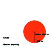
|
The very, very, worst case scenario (given the mothership did not burn up in the atmosphere, so must have passed let's say minimum 200 km) would put the lander off track by 1300 km perpendicular to its trajectory, which will give an atmospheric entry angle of 52 degrees and an error in landing location of 3081 km. That's absolutely the very worst case scenario, I can't create a bigger error given the fact that the mothership obviously survived...
So 'most likely' error would be in the range of 1481 km maximum and absolutely worst case error would be 3081 km. It looks to me like the lander was targeted for the Hellas bassin (they seem to have targeted for locations imaged by Mariner 4/6/7 so targeted area must be within one of these pictures), so draw an E-W elips with a maximum radius of 1481 km centered on the Hellas location and start searching...
Note this is all 'back of the envelope' calculating, obviously a lot of factors aren't taken into account but it give's the basic idea of what error we are looking for.
Regarding Mars 3 and 6, the Perminov booklet states a maximum allowed error in atmospheric entry error of 5 degrees, if you ignore all other factors, this gives a landing elips with a maximum radius of almost 300 km (any bigger error and they wouldn't have survived entry). It remains a very big area to search...
Regards,
Geert.
Posted by: Geert Feb 14 2009, 05:41 AM
Forgot to mention that according to the above reasoning, the crash location of Mars 2 must be to the WEST of Hellas, as we know it entered too steep. So it must be at least 300 km west of its intended spot (atmospheric entry angle must have been more then 5 degrees too steep, otherwise it would have survived), and it is likely no more then let's say 1500 km to the west (given the final orbit of the mothership) but definitely no more then 3100 km west of Hellas (otherwise the mothership would have burned up). It remains a big, big area...
|
Track projected on Google Mars. If we assume a landing error of 700 km (which correspondents with a most likely offtrack of 150 km, given the mothership entered an orbit with 1350 km perigree instead of 1500 km) then the targeted landing site would be close to 45S 70E which is almost dead centre in Hellas. I am trying to find out whether this area is inside one of the Mariner 7 images.
Anyway, no matter how I try I can't get Mars 2 to end up anywhere near 4 N. This also does not work out with the mothership ending up in an orbit with a 49 degree inclination, given the relatively small impuls of the lander-engine the atmospheric entry point must be close to the groundtrack of the mothership, which is conform with the 45 deg South locations but definitely does not work out for any location on the northerly hemisphere.
Regards,
Geert.
Posted by: nprev Feb 14 2009, 07:10 AM
Thank you for this very comprehensive and interesting analysis, Geert.
I'm more convinced than ever that the only way that these landers will ever be found is by somebody tripping over them in the year 2300 or so. We've already seen that very recent meteoritic impacts leave pronounced scars on the Martian landscape, which is a significant contribution to the S/N ratio; given also the large uncertainty in landing locations (to say nothing of circumstances), there's really no assured way to find them from orbital imagery.
Now, since historically every absolute statement I've ever made has been 100% wrong, let's sit back & wait for the break-through.
Posted by: Geert Feb 14 2009, 08:09 AM
Okay, one more remark and then I leave you in peace
You quote Marov & coauthor, Icarus, 1973 for Mars 2 atmospheric entry at 45 south, 313 west, with crash near 45 south 302 west.
Now covered distance is 11 degrees longitude, this is (11/57.3 * 3360)COS(45) = 456 km
If we assume atsmopheric entry was at 100 km altitude, with a purely ballistic trajectory and discounting all atmospheric influences (..) then the entry angle must have been ATAN(100/456) = 17 degrees.
Now I remarked the lander was most probably 150 km off track on its trajectory (given the fact that the mothership ended 150 km low on perigree), if you calculate the entry angle from this fact then the entry angle must have been 90 - ASIN((3396-150)/3396) = 17 degrees !!!
Seems almost too good to be true...
Posted by: tedstryk Feb 14 2009, 02:56 PM
The altitude typically used today is 125 km for atmospheric entry. I am not sure what was used in this mission.
Posted by: SFJCody Feb 14 2009, 03:57 PM
I think it might be sooner than that, maybe before the end of the century. Remember how distinctive in colour artificial objects imaged by HiRISE have appeared.
Perhaps some future orbiter using optical communication as standard will be capable of returning multi-spectral imagery with CTX-like coverage and HiRISE-like resolutions.
Posted by: yurdel Apr 22 2009, 02:07 PM
please visit http://mars3.gornai.ru - my attempt of animation Mars-3 mission(in russian)

|
Posted by: Geert Apr 22 2009, 02:48 PM
Very good and as far as I can judge technically correct animation!
You quite often see the mistake that the solid fuel engine on the lander was used for a braking manouevre, which is incorrect, it fired perpendicular to the flight path and thus only decreased the passing distance (from 1500 km to almost zero), you show it correctly in your animation.
Only remark is that you show the parachute separating on firing of the soft landing engines, the way I read the booklet of Perminov ('The difficult road to Mars') and especially the drawing on page 47 it seems to me like the parachute remained attached to the softlandingrocket and the instrument shell (similar to what was done with Pathfinder and MER), after the lander is released the softlandingrocket is shown more or less shooting into the parachute and taking the whole thing away from the lander.
I have been searching through the HiRISE images a lot in the vague hope of finding any sign of Mars 3 or Mars 6 but it's seeking for a needle in a haystack, there are lots of 'suspicious stones' but nothing which really shows hopeful. It's such a big, big, area, I'm afraid we will have to wait until somebody accidentally stumbles over the thing in a hundred years or more, and hopefully you're animation is then still around to show them what they've found!
Posted by: tolis Apr 22 2009, 09:03 PM
Hi,
Nice video!
One search method that *might* work for Mars 3 is to scan the area by magnetometer on a near-surface balloon.
Mars 3 landed in an area that we now know is characterised by strong remanent magnetisation. Being made of metal I would imagine that
it has the same effect on magnetic field lines as, say, a submerged submarine has on Earth's magnetic field. Perhaps a balloon-suspended magnetometer
surveying the area at an altitude of a few hundred metres can pick up its signature. This is an involving process to be sure, but
not quite as involving as someone going over the surface with a metal detector.
Tolis.
Mod: no need to quote the whole previous post.
Posted by: Geert Apr 23 2009, 01:06 AM
I wish somebody came up with the budget to do that
But seriously, the area is tremendously big, those landing coordinates are only very, very, vague. The soviets did not have clear ephemeris data of Mars at the time of the landing, the whole EDL process was completely pre-set and fixed, and the entry was ballistic with no guidance steering or anything. I expect only the latitude is more or less known (given the EDL procedure the lander should end up at a latitude which corresponds with the inclination of the orbit around Mars the mothership ended up in), but longitude is very, very uncertain. It can easily have ended up hundreds of kilometers off target, so even with a balloon you will have a tremendous area to survey...
The amazing fact that we still haven't been able to find the wreckage of MPL (of which we are reasonably certain where it should be..) shows just how difficult it is to find 'lost' spacecraft. Mars 3 and 6 are much smaller, there parachutes are probably (almost?) invisible by now and the craft covered by dust (and more or less resembling an average stone..). And it's not that you don't find anything, if you look in the HiRISE images there are lots and lots of big stones over there, and the more you look the more 'suspicious' objects you start to see.. The frustrating thing is that in the end even HiRISE doesn't have enough resolution to clearly identify a Mars 3/6 sized lander (covered with dust), and if you don't find a very clear sign of a parachute then in the end the only solution would be to go down there yourself to check each and every of those suspicious stones, wish I could...
Posted by: yurdel Apr 23 2009, 01:56 AM
...
Only remark is that you show the parachute separating on firing of the soft landing engines, the way I read the booklet of Perminov ('The difficult road to Mars') and especially the drawing on page 47 it seems to me like the parachute remained attached to the softlandingrocket and the instrument shell (similar to what was done with Pathfinder and MER), after the lander is released the softlandingrocket is shown more or less shooting into the parachute and taking the whole thing away from the lander.
...
Thanks!
I'm animate this picture -

|
Posted by: nprev Apr 23 2009, 02:06 AM
That was very cool, Yurdel; extremely interesting work, thank you!
Posted by: Geert Apr 23 2009, 03:10 AM
The booklet of Perminov you can download http://klabs.org/richcontent/Reports/mars/difficult_road_to_mars.pdf
The drawing you animate is on page 50 of the pdf, the picture I am referring to is on page 51. There is indeed a difference in how the parachute is released. On page 49 of the book the description is:
This seems to indicate the parachute remained attached to the parachute container while the soft landing engine was firing (as shown in page 51 drawing), but I agree that the 2 drawings differ in this, I'm afraid only way to make sure is find one of the original technicians and ask...
I'm also interested in what was the color of the parachute, some of the artwork seems to suggest it was red-white which is a pity given the red colored landscape on Mars, they should make parachutes for Mars landers bright green or something...
Posted by: tedstryk Apr 23 2009, 09:43 AM
Amazing work!
Posted by: Bjorn Jonsson Apr 24 2009, 12:18 AM
Wow - this was and extremely interesting piece of work.
Posted by: 4th rock from the sun Apr 24 2009, 09:11 AM
Very nice animation! A step by step illustrated time-line, using stills from it would also be nice and informative.
Posted by: hendric Apr 24 2009, 04:40 PM
Yurdel,
Very cool. Did you do this for a class? Do you have plans to do other missions?
Posted by: djellison Apr 24 2009, 04:50 PM
Very nice - I've always thought it would be fantastic to have old missions given the same CG treatment as MER and Phoenix. This is the first step on that road!
Posted by: mhoward Apr 24 2009, 05:12 PM
Very nice! The vector animation somehow suits the earlier period of time that this probe comes from.
Posted by: yurdel Apr 25 2009, 02:27 AM
Very cool. Did you do this for a class? Do you have plans to do other missions?
Thanks to all!
Yes, I will do also other missions.
Posted by: PDP8E Dec 3 2009, 10:06 PM
Happy MARS 3 Landing Anniversary (well, yesterday: Dec 2, 1971 -- Dec 2, 2009)
It has now been 38 years and only one HiRise image of the neighborhood!
We shall find you yet!
Cheers
(this thread is 2 years old...yikes!)
Posted by: yurdel Dec 15 2009, 09:22 AM
The flashclip about Mars 3 has been added by music and other scenes - http://mars3.gornai.ru
Posted by: Phil Stooke Apr 19 2011, 03:54 PM
Resurrecting an old thread... but it seems better than starting a new one, especially because the images are just above this post... I just had one of those epiphany things.
I was looking at this:
http://www.mrc.uidaho.edu/entryws/full/programme_detailed.html
(Presentation 1.41 about Venera probes, but it also covers Mars 3 and Mars 6). A picture and diagram of Mars 3 shows the dual camera system - it had two cameras like Luna 13, not one camera like Luna 9. But the Luna 13 panoramic image starts with a messy area which is really a closeup of the second camera (which failed to operate). Is this what is being viewed in the fragment of a panorama from Mars 3? In this view it would be real image data, but useless - if the Luna 13 image is anything to go by it's not a reflection of the surface of Mars in the camera body. But it might explain what is being seen.
Phil
Posted by: yurdel Nov 29 2011, 11:06 PM
My congratulations on forthcoming anniversary landings to Mars of Mars 3 lander! 40 years of silence and riddles.
This photo is made in the beginning of this year in Memorial Astronautics Museum in Moscow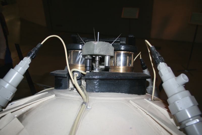
Other photos on a site http://mars71.ru/fotos.php
Posted by: Paolo Mar 18 2013, 07:52 PM
a picture of a Mars-71 lander during impact tests

|
Posted by: volcanopele Apr 11 2013, 05:15 PM
Mars 3 hardware may have been spotted in some HiRISE images. The parachute and heatshield look convincing to me.
http://www.uahirise.org/ESP_031036_1345
Posted by: remcook Apr 11 2013, 06:17 PM
Very nice 
"Philip J. Stooke from the University of West Ontario, Canada, suggested the direction of search and offered helpful advice. Arnold Selivanov (one of the creators of Mars 3) and Vladimir Molodtsov (an engineer at NPO Lavochkin, Moscow) helped with access to data archives. "
http://www.jpl.nasa.gov/spaceimages/details.php?id=PIA16920
Posted by: TheAnt Apr 11 2013, 07:39 PM
I've read the text and found that they did their homework well, with models of what each component would look like etc. Good job.
But the fact that the images do leave room for other interpretations leaves me still hesitant.
Yet if the further studies they mention do show that this is the real thing I do say congratulations to Vitali Egorov, Alexander Basilevsky and others for the detective work of locating Mars 3!
Posted by: Phil Stooke Apr 11 2013, 11:04 PM
I did offer some advice on this, though I had nothing to do with finding the objects in the image. But I don't actually see that reference to me in any of the links.
Phil
Posted by: Explorer1 Apr 11 2013, 11:11 PM
It's the 2nd paragraph from bottom on this page; weird how many repeat 'home pages' there are for missions.
http://www.nasa.gov/mission_pages/MRO/news/mro2013411.html
Posted by: J.J. Apr 12 2013, 12:47 AM
One similar feature would be easy to explain away; several anomalous ones together, much less so, IMO.
If they found this, I can only smile and clap. Amazing work, amazing crowdsourcing.
Posted by: Zelenyikot Apr 12 2013, 06:57 AM
Your thought of a movement trajectory very much helped.
Important argument - chain length on retrorocket. HiRise showed 4,8 m, and check according to drawings in NPO Lavochkin - 4,5 m + retrorocket engine.
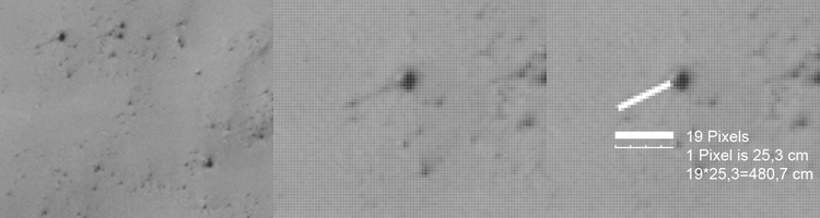
Posted by: TheAnt Apr 12 2013, 10:00 AM
Oh yes I did note that, and it's one reason I found this finding interesting enough to reply to.
And we do know Mars 3 are in this area, or perhaps somewhat to the north.
Yet at 25cm per pixel is the highest resolution we might get. (For the near future at least.) And that leaves the lander and those retrorocket parts at a size just at just a few pixels wide. Subsequent images where the light comes from different directions might perhaps give us an better idea of the hight of each of these item. which might give more credence to this.
Posted by: Liss Apr 12 2013, 11:49 AM
Phil
The most full account (in Russian) by Zelenyikot himself is here: http://habrahabr.ru/post/175827/
With reference to you, of course.
Posted by: vikingmars Apr 12 2013, 12:21 PM
Phil,
As our "International" UMSF cartographer, could you, please, be so kind to tell us what are the coordinates of the Mars 3 Lander itself on those images (South with E and/or W longitudes) ?
Thanks again so much in advance and warmest regards, VM
Posted by: Phil Stooke Apr 12 2013, 03:39 PM
Darn it, my atlas is now out of date.
According to my preliminary calculations on the newest image (map-projected), the lander is 3201 pixels north of the image centre and 1886 pixels west of the centre. That makes it 800 m north or 0.013 degrees north, and 471 m west or 0.008 degrees west.
That would give the location of 45.045 degrees south, 202.023 degrees east (157.977 degrees west)
Phil
Posted by: elakdawalla Apr 12 2013, 06:33 PM
Good thing you're working on a second book
Zelenyikot wrote a http://habrahabr.ru/post/175827/ about the process; I've translated it (with Google translate and Zelenyikot's help) and annotated it and http://www.planetary.org/blogs/guest-blogs/2013/0412-how-we-searched-for-mars-3.html.
Posted by: vikingmars Apr 12 2013, 07:45 PM
Thanks so much Phil !
Posted by: tasp Apr 12 2013, 11:17 PM
Orientation of the items on the surface was as expected is pretty significant, IMO.
If confirmed at some point, it is heartening to know so much went correctly during the mission. Late 60s/early 70s technology and they got a probe on the surface, count me thunderstruck. Impressive accomplishment!
IIRC, there was some speculation (if this is the right mission) the parachute might have come done on the probe, which would have been a frustrating outcome. To there credit, that may not have happened.
LOL, just pondering the imaging wizards here and elsewhere might already be trying to match up surface rocks supposedly visible on the partial video frame sent down with the images possibly showing the hardware with the surface features in the area.
Posted by: stevesliva Apr 13 2013, 02:10 AM
That would've been an interesting way to explain the brief transmission, and then silence. However it's hard to imagine the chute was radio opaque.
Posted by: Explorer1 Apr 13 2013, 03:07 AM
I'm pretty sure there was no identifiable data in that image, since what looks like the 'horizon' is actually vertical. And since Mars 3 appears to be right side up, it can't be even that.
Only way to figure it out for sure would be to send something to get the 'ground truth'.
Posted by: Geert Apr 13 2013, 03:22 AM
To me, that's one of the most amazing things in the whole story, that apparently it came down almost exactly in the position they had calculated long ago (45S 158W). There were so many unknown factors (it was '71, the original landingsite might have been selected based on Mariner 4 images), that landing ellipse was hundreds of kilometers big, and then seemingly it ends up almost exactly on the calculated spot..
Posted by: ElkGroveDan Apr 13 2013, 04:42 AM
I wonder if the entire "chain" in the HiRISE image is all chain, or possibly the darkness at the beginning of the chain is a rock or some other soil discoloration causing the chain to appear longer.
Posted by: vikingmars Apr 13 2013, 05:46 AM
Solving the Mars 6 landing mistery would be great also...
Posted by: Zelenyikot Apr 13 2013, 07:04 AM
It not the rock, is the engine of soft landing.
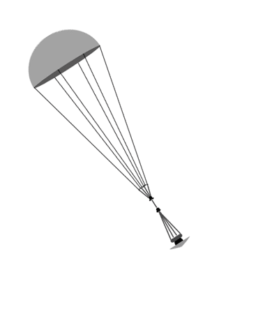
We will be engaged in it
Posted by: Phil Stooke Apr 13 2013, 12:20 PM
Luna 9 had one camera, but Luna 13 had two - but only one worked. The Luna 13 panorama starts with a view of the second camera, a fuzzy blob of light and dark patches.
http://mentallandscape.com/C_Luna13_2.jpg
( thanks to Don Mitchell for collecting this and many other images here:
http://mentallandscape.com/C_CatalogMoon.htm
Mars 3 had the same dual camera design as Luna 13. If there is any real information in the Mars 3 image it is almost certainly part of the second camera, not the surface of Mars.
Phil
Posted by: Bill Harris Apr 13 2013, 01:16 PM
So this was an amazing precursor to the MSL "Skycrane" technique. Impressive, since it almost worked.
--Bill
Posted by: akuo Apr 13 2013, 01:41 PM
It did work, unless the landing shock somehow disabled the lander 14.5s late.
Posted by: vikingmars Apr 13 2013, 01:56 PM
Phil, I know, you are drooling over the Mars 3 images...
So, I decided to make a pixel overlap just for you (and also for our UMSF members) between the 2 HiRISE images PSP_006154_1345 and ESP_031036_1345 to show the Mars 3 lander with some more details...
The petals are readily visible now. This work is dedicated to you and your outstanding "Atlas of Mars" book. Enjoy !
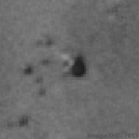
|
Posted by: TheAnt Apr 13 2013, 02:23 PM
This really look suggestive, thank you for your post and image.
Posted by: Phil Stooke Apr 13 2013, 02:37 PM
Thanks! Yes, it looks very good.
Phil
Posted by: mcaplinger Apr 13 2013, 04:11 PM
Given the changes in coordinate systems since then (tens of km difference at least) I'd say that's a coincidence at best. What we call 158W today is quite different from what they called it in 1971.
It was more like the Pathfinder/MER landing system without the airbags IMHO.
Posted by: dvandorn Apr 13 2013, 06:17 PM
Well... the early Soviet Luna moon landers (Lunas 9 and 13 in particular), which were configured somewhat similarly to the Mars 3 lander, did have airbags. Are we certain that Mars 3 did not employ them?
-the other Doug
Posted by: Bill Harris Apr 13 2013, 06:17 PM
Yes, it is closer to an airbagless MER-style landing.
--Bill
Posted by: Phil Stooke Apr 13 2013, 06:49 PM
Mike said:
"Given the changes in coordinate systems since then (tens of km difference at least) I'd say that's a coincidence at best. What we call 158W today is quite different from what they called it in 1971."
The coordinate grid is pure geometry, so the only thing which may be different is whether planetocentric or planetographic coordinates were quoted. What changes as we get better control is the locations of specific features relative to the coordinate grid. The lander is just to the west of a crater, and the coordinates given for that crater might have changed quite a bit from the Mariner 4 map to Mariner 9, Viking and MOLA coordinate systems. But if you just project the lander down a vector to a lat-long location, that prediction would not change with time other than being given as planetocentric or planetographic.
Phil
Posted by: akuo Apr 13 2013, 07:40 PM
--Bill
The point was that I'd find it very unlikely that it survived for 14.5s after landing and then got killed by the shock somehow.
The likeliest scenario is a programming error or similar for the early part of surface operations imo.
Posted by: mcaplinger Apr 13 2013, 07:49 PM
I think you're forgetting about the IAU prime meridian definition.
Posted by: Paolo Apr 13 2013, 08:40 PM
Soviet Mars landers were protected during impact by a foam shell. you can see it discarded beside the lander proper in my http://www.unmannedspaceflight.com/index.php?s=&showtopic=4806&view=findpost&p=199188
Posted by: Geert Apr 14 2013, 07:48 AM
According to the booklet from Perlimov ( http://klabs.org/richcontent/Reports/mars/difficult_road_to_mars.pdf ) airbags were discarded because they feared the exhaust from the retro rocket would damage them (the Pathfinder system used a much longer sling to separate rocket and lander), that's why they used foam instead. The system was quite robust and extensively tested on Earth (Donald Mitchell recently posted a very good video of the Mars 3 lander tests on Facebook, for those present there).
Personally, I suspect the lander was not at fault, but the relay via the Mars 3 orbiter failed. Remember the EDL sequence they used was quite different from other missions, during the landing the Mars 3 mothership passed straight overhead at only 1500 km distance, quite a close pass, and at the moment of touch down it was already descending towards the horizon. Perlimov states a average communication window of about 18 minutes, but most of that window was already passed when the lander started transmitting (about 2 minutes after touch down), so they probably had less then 5 minutes left in the comms-window at the start of transmission. Now, that's an optimal situation, if the lander was tilted and/or partly obscured behind a hill or crater, it will loose comms much earlier, so it's not really amazing it lost comms after about 14 secs.
Important item is also that the lander was transmitting via two different channels at the same time, and both channels were lost at exactly the same moment. If there was a technical failure, there is a reasonable chance of some time interval between failure of both channels (not necessarily, but likely).
The Soviets most likely never expected more then one picture at the very most during that first comm-window, but the Mars 3 mothership was supposed to steer itself in a 25 hr orbit, which would allow daily passes over the landing-area, so most data would be returned during the next (full) comms window (basically, the same was done during Luna-9, 13, which also returned most pictures and data the day after landing). The lander was programmed to 'sleep' until it received a signal from the orbiter at the start of a new comms-window. Unfortunately however, the Mars 3 orbiter failed to steer itself in the proper orbit, and instead ended up in a very eliptical orbit, with a period of some 14 days. By the time it finally returned above the landingsite, the battery's of the lander had long since expired.
Failure of the relay seems to me much more likely then a failure of the lander. After touch down a whole sequence of events was executed before it could start transmitting (the foam insulation has to be discarded, the pedals have to be opened, pushing the thing upright, then antenna's and meteorological sensors have to be deployed, etc. All of these things must have happened, otherwise it couldn't start transmitting, so it must have survived touch down and worked nominally for the first few minutes. Usually things fail on touch-down (crash, splash, whatever), if it survived that and deployed its antenna etc, it seems weird that it would fail 14.5 seconds after start of picture transmission. Loss of the relay-signal then seems a lot more likely given the fact that the orbiter was already low above the horizon..
Comparing the Mars 3 image with the Luna 13 panorama (same camera system) does indeed perfectly explain what we are seeing in those few frames: not the Martian landscape but only the frame of the second camera. Grab the first few frames of the Luna 13 picture and you get almost exactly the same picture as that Mars 3 image..
Posted by: Paolo Apr 14 2013, 09:52 AM
you can see some of the Mars-71 hardware and tests in this video http://www.youtube.com/watch?feature=player_embedded&v=tVJfjDOa3TI#!
Posted by: nprev Apr 14 2013, 10:58 AM
Geert, that's by far the most cogent theoretical explanation of the failure I've yet seen. Thank you very much.
Posted by: TheAnt Apr 14 2013, 12:13 PM
That is indeed the explanation I have heard also, from Eugen Semitiov, he stated that the most likely cause of the failure were failure of the lander to communicate.
So thank you for refreshing my memory on all the details about that, since I honestly had forgotten most of why it were the case.
And back then it were indeed the explanation I found to be the most plausible.
Posted by: Paolo Apr 14 2013, 12:20 PM
a similar cause has also been given for the loss of contact with Mars 6: the flyby bus set while the lander was still descending to the surface, and the planned orbital relay (Mars 5) had failed days before
Posted by: vikingmars Apr 14 2013, 02:45 PM
How interesting ! This is exactly what my uncle Antoine Mizzi, Science Director of the joint USSR-French "Signe-3" mission told me when I was young.
Link to the Signe-3 Soviet movie : http://videotheque.cnes.fr/index.php?urlaction=doc&id_doc=3255
He stayed 6 months in USSR in 1975 and on many occasions, he met with people involved with the Russian planetary science programs. They were very confident that the Mars 3 lander survived indeed its descent, because all tests done on Earth showed a strong survavibility of the hardware and because they had barely no computer on board, just a lot of automations with events built on switches, etc... After his coming back to France, he told me other stories about the Soviet "Mars" programs that went much beyond the events mentioned inside the "Difficult Road to Mars".
All what I can say is that the Soviet "Mars" teams had their works a lot delayed also for political and ideological reasons that had nothing to do with science at all... And although he was French, my uncle did suffer a lot in USSR about this also during the Signe-3 program, because he was treated like his Soviet counterparts which had hard times also being submitted to military discipline and daily KGB surveillance (complaints to the Soviet Government were issued by CNES on a later stage).
Posted by: Geert Apr 14 2013, 03:30 PM
Correct, although the scenario with Mars 6 is slightly different as it was modified to carry a secondary transmitter which send a data signal to the mothership during descent, so we have some data, which at least clearly indicates that the parachute deployed correctly. However, according to Perlimov, the actual lander was designed to communicate through the Mars 5 orbiter (similar to Mars 3, the mothership passed close and fast at 1500 km and went below the horizon almost immediately after touch down, however in this case the Mars 5 orbiter would be there to relay the lander signal). The Mars 5 orbiter however failed well before Mars 6 arrived, so the Soviets must have known prior to the landing that they wouldn't receive any surface transmissions, even IF the lander survived touch down, all they got were the transmissions during descent, send on a different frequency via the mothership relay. The mothership was not designed to go into orbit and only on a (fast) fly-by trajectory, so without the Mars 5 orbiter the surface part of the mission was lost anyway.
Whether Mars 6 survived its landing we might never know for sure, but finding the craft would at least give us some more information. In his booklet Perlimov states that the descent transmitter was designed to cut-off when the retro-rocket ignited (30-60 mtr above the surface), so the fact that the transmission ended doesn't necessarily mean the craft crashed. From the doppler-signal we know it was descending at 63 m/sec at the moment of LOS, that's too fast to survive touch-down but confirms with its designed descent-rate under parachute, so the descent-rate was nominal and IF the retro-rocket ignited, it might still have survived (to remain for ever silent, without a working relay). On the other hand, the doppler signal indicates the craft was swinging very roughly under its parachute, much more then was expected, and the radio signal from the descent transmitter didn't cut off at once, but it 'stuttered' a couple of times, before falling silent, as if the craft was bouncing down some hill or something. It MIGHT be that the descent-radar (which should trigger the retro-rocket) malfunctioned or that it's signal was lost due to descending above some steep hill side (returning little or no reflections back to the radar), in that case Mars 6 crashed and all we will find is a parachute and the wreckage of the lander. There remains however a chance that the retro rocket did ignite and the landing succeeded (the ignition of the retro-rocket is a rather violent event, the 'bouncing' LOS of the descent transmission might just be caused by this rough separation). The only thing we know for sure is that the Mars 5 relay was dead and if it survived there was no longer anybody listening to its signal..
Personally, I don't have much hope we will find Mars 6, it's a difficult terrain there and there's a lot of uncertainty in its coordinates, but I didn't have much hope for Mars 3 either and I hope history will prove me once again wrong.
Posted by: bobik Apr 14 2013, 05:52 PM
I do not consider this a plausible theory. Because that would imply that the Soviet mission designers were bumbling idiots. Not very probable, I think.
Posted by: Explorer1 Apr 14 2013, 06:04 PM
No more improbable than installing an accelerometer backwards? Mixing up metric and imperial measurements?
Everyone makes mistakes; these are the same folks who got back pictures from the surface of Venus, or samples from the surface of the Moon!
I think those proves their competence quite well.
Posted by: djellison Apr 14 2013, 06:22 PM
It's more than plausible. Consider the original Cassini-Huygens plan. 4 minutes of relay after touchdown. Read the rest of the Mars 3 plan - they were expecting the orbiter to be back relaying a few hours later.....just like, say MGS -> Odyssey after the MER landings.
Posted by: Geert Apr 14 2013, 06:28 PM
They definitely weren't. As I've stated already, they expected to get all the results during the next pass of the mothership-relay, 25 hrs later. It was just bad luck that the mothership failed to enter the correct orbit.
All the figures add up very nicely, a quick back-of-the-envelope calculation already gives you a comm-window of about 18 minutes given the orbiter periapsis of 1500 km. Next, you can calculate the lander trajectory from the velocity-changes and distances given, which indeed nicely shows you that the mothership was immediately overhead at the moment the lander entered the atmosphere. So, in that position you have 9 minutes left in your 18 minutes window. EDL takes about 6 minutes, during which time the lander quickly looses speed and the mothership descents further towards the horizon. So, on touch-down you've got about 3 minutes left in your comm-window. Then it takes 2 minutes for the lander to deploy its antenna's etc and start transmitting (also quoted everywhere by the Soviets), and foila, you've got only 1 minute left to get your picture. Any small hill or a slight tilt of the lander, and you've got only 14 seconds..
They must have known all along that they wouldn't receive much data during that first pass, at best only confirmation of landing, but there was no worry, the orbiter would pass overhead again 25 hrs later and the lander was programmed to send all its data during that next pass (just like Luna 9 and 13 also send most of their data one day after landing). However, the mothership got into a completely wrong orbit (14 days period instead of 25 hours) and the lander missed its relay. Just bad luck.
Posted by: TheAnt Apr 14 2013, 06:43 PM
Merci.
With several sources we can put some faith in that this indeed is factual then.
And yes Mars 3 were indeed on one mechanical automatic sequence.
There's not much to add and no new questions can be asked since Mr Semitiov have passed away: Yet I tend to remember that he also claimed that the short transmission indeed were supposed to be one actual image transmission and not noise. Now that we have the possibility & hypothesis that the short sequence might show the other camera, that claim might be vindicated - though posthumously.
Posted by: Paolo Apr 15 2013, 11:39 AM
thinking about the foam shell that should have protected Mars-3 during impact, it should be plainly visible, being a little bit larger than the lander. is anything similar visible in the environs? I can't see any shell-like object.
or maybe it was light enough to be carried away by the wind? just pondering...
Posted by: vikingmars Apr 15 2013, 11:59 AM
or maybe it was light enough to be carried away by the wind? just pondering...
In fact the so-called "Shock Absorber" was part of the egg-shaped structure itself, covering the Mars-3 lander. I was told that the main idea was to jettison those parts only when the lander came to a rest. My guess is that the bottom section was really crushed flat on impact and most of it is probably still remaining under the lander, because it was positioned between the four petals when jettisoned. Only the segments of the topmost part of the shock absorber covering the "egg" structure should be visible lying on the surface around the lander... Now they must be covered by a lot of Martian dust and are looking like rocks !
Posted by: Paolo Apr 15 2013, 01:44 PM
from all of the pictures and videos I have seen (see post #24), the shock absorber was to remain in one piece (plus smaller debris), which should be clearly visible, being as large as the lander proper
Posted by: Mr Valiant Apr 15 2013, 01:47 PM
Dream come true. After '42' years, we've found it. Well done all.
Looking at VikingMars pic http://www.unmannedspaceflight.com/index.php?act=attach&type=post&id=30020
Could the dark spot to the left of the probable lander be the PropM Rover?
Seeing as the Lander was following a set routine, thereby executing its functions based on an internal clock,
could it have not released the PropM based on its subroutines. Or was the release to be commanded from the
ground?
Posted by: Mr Valiant Apr 15 2013, 02:02 PM
Oh, and on the durability of electronics when it comes to impact. Don't forget, the Allies during WWII developed
anti aircraft shells with proximity fuses. They could rapid fire these AA FlaK shells to heights of several kilometres and they would detonate if they
detected the proximity of 'metal', otherwise they would fall back to the earth intact or used a timer to explode and disperse harmlessly in the atmosphere.
Used very effectively against the V1. (Not against the V2, though they where working on it).
And this was the days of Valves and paper capacitors.
Not sure of impact speeds, but the drop for M3 would probably break a mans legs, but for the instrumentation would be well within the design envelope.
ADMIN: Post edited - unnecessary comments removed
Posted by: djellison Apr 15 2013, 02:13 PM
The rover was tiny - absolutely tiny. Sojourner was 65 x 48cm and its location is debatable in HiRISE imagery. PropM 21 x 16cm - less than 1/8th the 'surface area' seen from above.
I think using the word 'probable' on locating something <1/2 the size of a HiRISE pixel is a stretch, at best.
Posted by: Geert Apr 15 2013, 02:50 PM
Agreed, that's indeed also my biggest doubt/puzzle with regards to the whole find. If you watch the various video's (especially the one Don Mitchell posted recently on FB) then the whole top of the egg plops off in one, big, piece, bigger then the lander itself, and comes to rest quite close to the lander, it should be visible.
On the other hand, those tests were done on Earth, Mars has less gravity so it will probably be thrown a bit further, and it might be any of the 'stones' we see lying around the lander.
The top must have detached though, otherwise the pedals and antenna's couldn't unfold and there would have been no transmission.
As to the prop-M Mars-walker, it was way too small to be detectable by HiRise, no chance we can see it, even if it detached from the lander.
Posted by: Zelenyikot Apr 15 2013, 05:35 PM
The foam shell candidate suitable by size is available in 25 meters.

Posted by: Paolo Apr 15 2013, 05:43 PM
thanks. the find looks more and more intriguing
Posted by: dvandorn Apr 15 2013, 05:50 PM
Also, depending on the density of the foam used in the shell, it could possibly have been blown a little in the wind over the years. Especially if it was oriented at any point with the hollow end pointed towards the direction of the prevailing winds.
-the other Doug
Posted by: bobik Apr 15 2013, 05:57 PM
Make success dependent on a perfect orbital insertion and the chance to survive one long cold Martian night? They would never take such a risk. Moreover, Perminov clearly says that the duration of the second communication session would be only 0.7-5 minutes. This second session is only an encore.
Posted by: Decepticon Apr 16 2013, 07:53 AM
I hope there are plans for future pictures of the same area.
Posted by: Geert Apr 16 2013, 12:51 PM
I'm quite certain there's a translation mistake in that sentence, as only a few lines above it, he states a communication window of 18-23 minutes (page 46). He then states that the second session would be initialized by a signal from the orbiter, and depending on the location of the lander THAT signal would be 0.7 - 5 minutes. IMHO what he means to say is simply that the orbiter would spend up to 5 minutes on attempts to wake up the lander.
Just to be certain, I did the math again, it's quite easy to calculate the time the relay will be above the horizon for a stationary lander. For a 25 hr orbit of 1500-33000 km (as intended for the relay) and estimated dimensions of the lander, I get a communication window of 17 minutes. Sure, that's an optimal situation (with the orbiter passing right overhead), but that was exactly what they planned to do, that's the reason of the 25 hr orbit, synchronized with the rotation of Mars, so it would pass every day at the same time right over the lander. Given the circumstances, it was the optimal orbit for a relay (far less optimal for science operations, as a large part of Mars would remain out of view).
As to surviving the Mars night, the lander was battery powered so it wouldn't mind much about day or night (the day is just as harsh as the night, but it's none different from the situation on the Lunar surface). The lander was extensively tested for this, and would be able to survive for several days. AND remember that this is the same schedule they used as with Luna 9 and 13, although those landers communicated directly with Earth (at a very much lower data-rate) there was only one groundstation so they could only communicate when the Moon was above the horizon at Jevpatoria. Luna 9 send one partial panorama right after landing, but there was hardly anything to be seen on it. Only the next day (night) did it send it's first full panorama picture and further science data. And the same happened with Luna 13, and with Luna 3 it took even much longer before they finally got their pictures, so they weren't afraid to take these risks, it had all been done before!
And finally, offcourse the scheme is risky, the whole thing was risky, but there was no other way. I've tried the math time and time again, and every time I come up with the same answer. If you use the scheme they used (and have been documenting quite excessively, all data you need is there to recalculate this) then there is no other way: the orbiter (relay) will be more or less in the zenit position (right above them in the sky) at the moment the lander reaches the atmosphere, and given the relatively 'low' pass (1500 km) and the high speed you end up with just a few minutes of surface transmissions at the very most, probably just enough to get confirmation that the thing has landed intact (if you're lucky). I would love to see a calculation which shows that you can get 18 minutes or more of surface transmissions right after landing with the given trajectory. No matter how hard I try, I can't get more then just a few minutes at the very most. To get a longer window, the mothership should pass much further from Mars, which it didn't.
We will probably never be sure if this is indeed the whole reason why the transmissions ended abrupty after 14.5 seconds, but it certainly seems a very logical explanation to me.
Posted by: Zelenyikot Jun 26 2013, 04:28 PM
Zelenyikot and Mars 3 in museum of Lavochkin Research and Production Association.
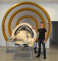
|
Posted by: Tom Dahl Jun 26 2013, 07:34 PM
That is a good clear photograph, thanks for posting it. Is the spacecraft an engineering model / prototype unit? It looks nicely detailed.
Posted by: Zelenyikot Jun 26 2013, 10:28 PM
Yes, it is the full-scale model.
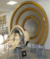
|
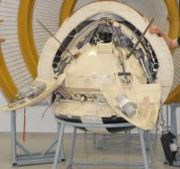
|
Posted by: Phil Stooke Aug 5 2013, 11:39 PM
The IAU has just named three craters (two very small) near the Mars 3 site after towns, two in Russia, one near the Mars 3 launch site. The latter, Tyuratam, is probably the most well-known name.
Phil
http://astrogeology.usgs.gov/HotTopics/index.php?/archives/496-New-Names-for-Three-Craters-on-Mars.html
Posted by: alex_k Oct 16 2014, 03:01 PM
Hi everybody.
I try to solve the puzzle of Mars 3 images - what did the spacecraft really send to us.
The orbital image of "mountains" was taken from the perfect Don P. Mitchell's site http://mentallandscape.com/C_CatalogMars.htm
After processing I got the follows:
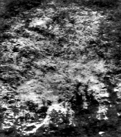
|
I suppose that there're Argyre plantia and crater Galle - the corresponding place found at Google Mars:
|
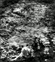
|
Does it seem correct?
Alex
Posted by: Phil Stooke Oct 16 2014, 03:47 PM
This was my interpretation:

|
Phil
Posted by: tedstryk Oct 16 2014, 11:05 PM
This is my interpretation, although this is from a scan, not from Don Mitchell. I was never certain whether the dark corner was the limb, a dark area, or a bad spot.
Here is a version I processed without the assumption that this corner is sky.

|
Posted by: alex_k Oct 17 2014, 05:52 AM
|
|
Phil
Hi Phil,
Your interpretation looks good. The big structures seems very similar to the Mars 3 image.
But there are two uncertainties:
1. I tried to compare your interpretatin with modern maps (layers of Google Mars) but I can't find match in details.
2. I think the orbital images were published in proper orientation, so reflecting seems unnecessary.
It's a really difficult question - what deformations were in the signals of Mars 3 and what information about them was known.
Orbital data were much less deformated than the signal from the lander, so I think they were decoded properly.
It would interesting be to confirm (or reject) my interpretation by using a model of Mars with detailed altitude map.
If to find the place in the proper perspective and to put the Sun low over the horizon on south-east (upper side of the image), we should get a very close picture.
Alex
Posted by: alex_k Oct 17 2014, 06:03 AM
Hi Ted,
Your site http://www.strykfoto.org/mars3.htm is great, thanks.
In my processings of Mars 3 images I didn't use any smooth noise reduction methods - using them we can lose important information covered in the deformated signals, mostly about details.
Instead of that my main method was a transformation of Fourier spectrum of the image - the images seems to have very reduced low frequencies, and I intensified them.
For Mars 3 images that gets very strong effect.
Ted, do you really have quality scans of the original signals? I'm very interested in the quality source of the data received from the lander. Is it possible to share them?
I'll share my result of processing the lander's singnal, but it is not certain enough because of use of Internet sources.
Alex
Posted by: 4th rock from the sun Oct 17 2014, 07:54 AM
Without knowing the image geometry (specially the field of view) it's hard to find candidates. There's the possibility that the image is flipped horizontally or vertically.
But a good guess it that the Mars 3 image should look like the Mars 4/5 images transmitted in low resolution (also on Don's site).
Some Mars 4 / 5 images had "reseaux" marks, and t I don't see them here. So perhaps the image is too degraded to show a useful image (only noise).
Posted by: tedstryk Oct 17 2014, 10:23 AM
I'll have to dig. I worked with this one many hard drives ago. I will say this. These images only had 250 lines. And it is incredibly noisy. And, frankly, even on the original journal page, it looked like it might have been photocopied. So without trying to clean it, Fourier transformation is just going to enhance noise. At any rate, in my version it is easier to see the outline of the crater Hooke as well is the albedo features at the bottom. Phil's location is correct.
4th rock, yes, Mars 3 had reseau, which can be seen in the attached image. I'm not sure the image in question isn't too degraded to see it.

|
Posted by: alex_k Oct 17 2014, 11:59 AM
But a good guess it that the Mars 3 image should look like the Mars 4/5 images transmitted in low resolution (also on Don's site).
Some Mars 4 / 5 images had "reseaux" marks, and t I don't see them here. So perhaps the image is too degraded to show a useful image (only noise).
Mars 3 had two cameras: "Zufar" with focus 350mm and angle of view 5.67deg and "Vega" with focus 52mm and ange of view 35.7deg. Mars 4/5 had advanced versions of the cameras.
Probably two Mars 3 orbital images were made by 52mm camera. But Mars 3 had very elliptical orbit ~1000 x 200000km so the images should be very different.
I suppose that the degradation of images at most caused by problems with communication equipment which deformated frequency structure of the signals.
And perhaps the information can be extracted by proper processing.
It depends on structure of signal, noise and on kind of applying Fourier transformation.
I agree that images look like they were photocopied. But it doesn't mean they actually were.
At the bottom I suppose we see long shadows covering some details on the surface and highlighing others. A sunrise.
Posted by: alex_k Oct 17 2014, 12:06 PM
The second orbital image which I tried to locate is "Atmospheric Edge", also from Don Mitchell's site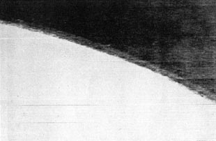
After contrast enhancement and debluring (1):
[attachment=33995:res_C_Ma...sphere_X.jpg]
After applying Fourier transformation (2):
[attachment=33996:res_atm.png]
Contrast processing again (3):

|
The image is actually very noised. After the step 2 probably we see regular noise, which replicates "ground" to the "sky" even twice. The Fourier transormation indeed enhanced it, like valuable details.
My interpretation. The "channels" on the left of the picture hint that it's somewhere near Olympus Mons.
Posted by: Phil Stooke Oct 17 2014, 04:36 PM
OK, two points. First, there is absolutely no geographical information in that image, and you can't use it to identify a surface location. All that texture is spurious.
Second, there were only three periapsis data-taking sequences, and maps of their locations have been published. One passes across Argyre, one just west of Hellas and one over Hesperia Planum (http://publish.uwo.ca/~pjstooke/marsatlas6.jpg)
The resolution of the haze layer shows this is a low altitude image so it has to be over one of those areas, and can't be over Olympus Mons.
Phil
Posted by: 4th rock from the sun Oct 18 2014, 02:17 AM
All that processing to the 2nd image only reveals the texture of the paper upon the image was printed
The fact that you are able to generate detail from a featureless image (it's overexposed) shows the danger of overworking the data.
I agree with Phil's interpretation of the equatorial image. It's consistent with a photo of albedo features, probably with bright dust clouds covering the lower parts of the surface.
That would give you higher contrast and some topographic effect without the need for shadows.
The Mariner 9 images show just that: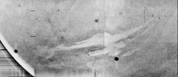
It's obvious that, on this case, it's Vallis Marineris, although it looks like a negative image.
Posted by: alex_k Oct 18 2014, 11:03 AM
Second, there were only three periapsis data-taking sequences, and maps of their locations have been published. One passes across Argyre, one just west of Hellas and one over Hesperia Planum (http://publish.uwo.ca/~pjstooke/marsatlas6.jpg)
The resolution of the haze layer shows this is a low altitude image so it has to be over one of those areas, and can't be over Olympus Mons.
Phil
Phil, I agree that it can't be Olympus Mons. You are right, my interpretation is wrong.
Here's a map of Mars 3 tracks in low altitude. Tharsis was really far away.
But I can't agree that the image looks like a paper texture. It seems possible but not very probable.
It's interesting to access to the original records to get more certain result.
The fact that you are able to generate detail from a featureless image (it's overexposed) shows the danger of overworking the data.
The image is really overexposed, but this fact doesn't determine that all details were degraded. Most "generated" details became visible after simple contrast enhancement.
About equatorial image. I think that both interpretations seem probable and it's interesting to check them - confirm one of them and refute the other.
For shadows it's enough to model the relief illumination, or to find an appropriate photo from MRO or Mars Express.
BTW, for the Mariner 9 image the same processing gets the follows:

|
More noise, more details.
Posted by: machi Oct 18 2014, 01:04 PM
Alex_k:
You are working with noise, your second horizon image and Mariner 9 image shows it clearly. You have the same structures in dark space as on the surface of planet.
Unfortunately those copies of copies of Mars 3 images shows only very little information. We can only hope that Russians will publish full quality images sometime in future.
Until then it's almost impossible to improve those copies.
As regards the location of Mars image of "equatorial mountains" based on projection of Mars 3 trajectory on the Martian surface my secret bet is that the most distinctive features in this image are part of west Nereidum Montes (in orange ellipse).
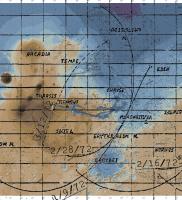
|
Posted by: alex_k Oct 18 2014, 01:43 PM
Your are working with noise, your second horizon image and Mariner 9 image shows it clearly. You have the same structures in dark space as on the surface of planet.
Unfortunately those copies of copies of Mars 3 images shows only very little information. We can only hope that Russians will publish full quality images sometime in future.
Until then it's almost impossible to improve those copies.
Thanks Machi.
I work with hardly noised images, it's clear. I attempt to extract valuable information from them.
I've noted that the "horizon" image has a replicative noise - structures of surface on the sky. The signal was transmitted line by line so previous data in a line can be replicated by not perfectly working comm equipment. But Fourier processing can also fill empty space with replicated fragments. My expectation is not to get a perfect realistic image - but to enhance valuable information, mostliy in strong but deformated details. Actually the method was designed to process the lander's signal, and maybe it is not very effective for noise reduction purposes in general.
On the processed Mariner 9 image we can see details that correspond to actual maps and very weakly recognisable on the source image. But Fourier artefacts may also be there.
Posted by: alex_k Oct 18 2014, 02:05 PM
About the lander's image. My attempt to recover it from the signal. Not certain because of qulity of source data and several unconfirmed assumptions.
[attachment=34009:m416_3.png]
The following photos were used for processing:
http://i.imgur.com/KlpytlJ.jpg
http://fotki.yandex.ru/next/users/roborebel/album/351274/view/959480
The interpretation: martian surface with print of lander's rolling after landing.
Posted by: vikingmars Oct 18 2014, 03:21 PM
Dear alex_k, they were a lot of discussings about the processing of this famous "picture" and it depends on its orientation.
Please, see posts :
http://www.unmannedspaceflight.com/index.php?s=&showtopic=572&view=findpost&p=52475
http://www.unmannedspaceflight.com/index.php?s=&showtopic=572&view=findpost&p=52584
http://www.unmannedspaceflight.com/index.php?s=&showtopic=572&view=findpost&p=52609
Posted by: Phil Stooke Oct 18 2014, 09:27 PM
I had posted my opinion about this somewhere here on UMSF and elsewhere. The Mars 3 camera system was like Luna 13 with two cameras (not like Luna 9 with only one). The first part of the Luna 13 panorama was a view of the other camera (which did not work, we never got images from it) - so the first part of the Mars 3 panorama is almost certainly a view of the other camera, not the surface of Mars. Any structure in it is going to be some combination of glare and shading, possibly including reflections (but who knows what of), plus noise and scanning artifacts etc. We really should not look for the surface of Mars in the image. The original mission scientists would have grasped at anything real in that image, as it would have been an incredible feat, but even they denied it had any value as an image of Mars.
Phil
Posted by: 4th rock from the sun Oct 19 2014, 01:07 AM
Here's my take on the Mars 3 "mountains" image. This is a conservative processing, consisting of manual histogram rebalance and hard median denoise. Finally I smoothed it with some blur and reduced resolution to the original 256 lines.
So I think that the details are real, not noise induced.
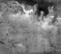
|
There are many possible matches around Argyre.
I can fit those patterns with the mountains around the basin, and interpreting the bright curved line as a channel might narrow it down.
Posted by: Geert Oct 19 2014, 08:48 AM
It's completely useless info, but the original Mars 3 orbit ranged out to more then 200 000 km from Mars.
Comet Siding Spring is passing Mars at some 120 000 km so inside the Mars 3 orbit making it potentially the closest man made object near the camet.
Offcourse Mars 3 is long since dead and its orbit was so unstable that it probably has perturbed a lot since then so we basically have no way of knowing where the thing is by now (it might have crashed into Mars or re-entered solar orbit for all we know) but should we happen to observe something crashing into the comet then who knows
Posted by: alex_k Oct 20 2014, 07:50 AM
So I think that the details are real, not noise induced.
Nice picture. It would be interesting to take a look at result of the same procssing of the "horizon" image.
But actually I don't see strong mismatches between our versions - there're no objects that contradict. Except of small details which were taken away by smoothing.
Posted by: alex_k Oct 20 2014, 07:51 AM
Phil
This version seems to be hardly probable. Cameras for Luna 13 and for Mars 3 where developed by A.Selivanov, and the experience of Luna 13 was taken into account in the next project. The schema when the scanning started from the second camera obviously was too risky to be repeated in the martian project.
Here's an acticle written by Selivanov where he discusses about possible image from the Mars 3 lander: http://libgen.org/scimag5/10.1134/S0038094613030064.pdf . The technical information is very interesting, some assumptions are disputable. But he couldn't write such article if he knew that the camera started scanning from the second one.
Posted by: alex_k Oct 20 2014, 08:03 AM
Please, see posts :
http://www.unmannedspaceflight.com/index.php?s=&showtopic=572&view=findpost&p=52475
http://www.unmannedspaceflight.com/index.php?s=&showtopic=572&view=findpost&p=52584
http://www.unmannedspaceflight.com/index.php?s=&showtopic=572&view=findpost&p=52609
Thank you for the refferences.
I think that you and 4th rock were right when you stretched the image to make it wider. The reason is follows. The camera on Mars 3 lander EA-046 was an advanced version of the Moon cameras YA-198 - they were almost the same but martian had higher scanning speed, 4 lines per second instead of 1. About the Moon camera it's known that it had two scanning modes: main (high resolution) and quick (the third mode was for technical purposeused for chooseing frame). In "quick mode" Moon panorama whould be transmitted in ~20 min againist 100 min in high resolution mode. I suppose that most reliable and probable implementation of "quick" mode was increasing speed of horisonal rotating of the scanner. If it is true, each line transmitted in quick mode has horizontal angle of view like 5 lines in standard hires mode - in other words, the camera missed about 4 lines.
The question, which mode would be chosen, if the communication window was only about 1.5 minutes and there was no second chance? (see Geert's perfect posting http://www.unmannedspaceflight.com/index.php?s=&showtopic=4806&view=findpost&p=199741) So the image's width should be stretched x5.
About 79 lines and "no contrast". I suppose that the signal was misinterpreted by the scientists. The data from the lander were received and recorded by the orbiter and lately transmitted to the Earth - there was no direct retranslation. So "received 79 lines from the lander" is just an interpretation of a part of the information pack received from the orbiter which has width more than 270 lines.
I enumerated the fragments of the source signal to reffer them. For my processing the image was filpped to be in proper orientation.
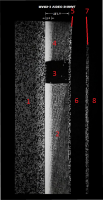
|
79 lines is the width of fragments 2-4. Fragment 1 has width of about 85 lines, and my statement that it contains complete received image. It's most quality fragment but like others transmitted with hard frequency deformations. It is not a white noise or telemetry, as offen interpreted. I suppose that fragments 6-8 also contain received image, but at very low level. So we have three replicants of the signal received from the lander. I processed, matched and composed them. My resulting image is a composition of 3 information layers.
How is it possible that the information replicated so many times in the signal? It's known that the lander transmitted simultaneously by two independent channels, and the data were recorded by the orbiter on at least two tape recorders. My hypothesis is that the playback was looped when transmitting to the Earth for most reliability. Thus when the record finished it was continued from the end in reverse mode. Reversing line by line transmittion means rotating the image at 180 degrees. So the white left of fragments 2 and 4 and brightening at the right of fragment 1 have the same nature - it may be caused by the orbiter's going away over the horizon (by Geert) or by upcoming electrical degradation. I suppose that fragments 5-8 is a playback from the second recorder.
Posted by: Geert Oct 20 2014, 10:36 AM
I would caution against trying to get too much out of this image, partly for reasons which have been mentioned here already.
Furthermore, as far as I know we don't even have absolute proof that this is actually the Mars 3 image at all!
From what I remember the filmstrip was found by some Western TV crew somewhere in some archive in Moscow and they concluded that it had to be the missing Mars 3 imagte. Unfortunately so much time has passed that we can't be 100# sure whether this is really the case. We might be looking at something completely different, not related to Mars 3 at all.
Remember, there is another picture which is said to be the Mars 3 recording (once again: said to be..).
http://2.bp.blogspot.com/-3FjLiiL0Has/T5Qmjw5b4_I/AAAAAAAAMAc/0DWCI4_opuY/s400/V_Mars3Signal.jpg
This is supposed to be the picture as it appeared out of the teleprinter while the signal was received.
IF (big IF) both pictures are true, then I wouldn't be surprised if the image you are using is in fact nothing but a photo-negative of a picture of that same teleprinter and it's printed paper.
in that case the block you mark as 3 is nothing else but the stylus of that same photoprinter and some other artifacts might in fact be also parts of that printer!
It was a historic event, so it is very well possible that they had a video camera trained on that teleprinter while the image was processed.
I have never read any mention from former Soviet sources that the received signal was stored as a video signal. It was a digital signal which was processed and then printed on an oldfashioned teleprinter of the type seen in the picture. IF the original signal is anywhere preserved it would be on some magnetic tape.
Posted by: alex_k Oct 20 2014, 11:27 AM
Furthermore, as far as I know we don't even have absolute proof that this is actually the Mars 3 image at all!
From what I remember the filmstrip was found by some Western TV crew somewhere in some archive in Moscow and they concluded that it had to be the missing Mars 3 imagte. Unfortunately so much time has passed that we can't be 100# sure whether this is really the case. We might be looking at something completely different, not related to Mars 3 at all.
Remember, there is another picture which is said to be the Mars 3 recording (once again: said to be..).
http://2.bp.blogspot.com/-3FjLiiL0Has/T5Qmjw5b4_I/AAAAAAAAMAc/0DWCI4_opuY/s400/V_Mars3Signal.jpg
This is supposed to be the picture as it appeared out of the teleprinter while the signal was received.
IF (big IF) both pictures are true, then I wouldn't be surprised if the image you are using is in fact nothing but a photo-negative of a picture of that same teleprinter and it's printed paper.
in that case the block you mark as 3 is nothing else but the stylus of that same photoprinter and some other artifacts might in fact be also parts of that printer!
It was a historic event, so it is very well possible that they had a video camera trained on that teleprinter while the image was processed.
I have never read any mention from former Soviet sources that the received signal was stored as a video signal. It was a digital signal which was processed and then printed on an oldfashioned teleprinter of the type seen in the picture. IF the original signal is anywhere preserved it would be on some magnetic tape.
Dear Geert, I would address you to the BBC film "The Planets", episode 6, 22:15 and later. Selivanov and Marov show the signal's photo and comment it.
About the another picture from printer, I suppose that it is not a received signal, but a result of early and not very successful processing.
It would be great if possible to access the magnetic tape with the record, I tried without a result. But Selivanov told that for the article he used the original signal received from the lander.
Posted by: 4th rock from the sun Oct 20 2014, 04:46 PM
Don't remember reading this. Interesting read and processing, and that seems to be the actual data. Somewhat similar to the teleprinter output and not like the BBC fragment.
I don't think the assumption of a tilted lander still holds. The Mars 3 on the surface photos we now have show it landed in the normal orientation.
As for the BBC image fragment, it shows the AGC system working and adjusting the image brightness, just as explained in several sources.
So it is a negative image, since the actual image brightness started at zero.
After that you have some image scanning with the a periodic dropout (or obstruction at source) that creates your "3" square. More to the left the signal degenerates into noise and then disappears. It seems to come back briefly and then it's gone forever.
All very consist with the "classical" interpretation of a failing transmitter.
Here's what I got from the "horizon" image based on the above assumptions. I filled the missing data block by interpolation.
My interpretation is that we are indeed seeing part of the lander.

|
But both images are hard to reconcile indeed.
Here's what the same processing brings out on the teleprinter image:
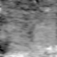
|
It looks more like an orbital image, much like the "mountains" photo discussed before...
Posted by: alex_k Oct 21 2014, 05:21 AM
So it is a negative image, since the actual image brightness started at zero.
After that you have some image scanning with the a periodic dropout (or obstruction at source) that creates your "3" square. More to the left the signal degenerates into noise and then disappears. It seems to come back briefly and then it's gone forever.
All very consist with the "classical" interpretation of a failing transmitter.
How do you think, if the image was negative, why the "3" fragment (mirror flyback) is not negative? The white rectangular pulses at the left of the fragmnt are clearly distinctive, like Selivanov wrote. But the lines cannot be partially inverted!
This interpretation seems contradictive.
It is a very conservative processing.
Take a look at my layers which I composed to the resulting image. They are matched to each other.
1. Fragment 1.
(preprocessed source - stretched result)

|

|
Posted by: alex_k Oct 21 2014, 05:26 AM
2. Fragments 2+4, rotated 180 deg.
[attachment=34048:test.png] [attachment=34049:layer2.png]
3. Fragments 6+7+8, rotated 180 deg (just stretched result)
The second source http://fotki.yandex.ru/next/users/roborebel/album/351274/view/959480 was used.
[attachment=34050:layer3.png]
The third layer is very extremal indeed, but it contains image. More quality sources are needed to refine this layer - the quiality of first two is enought.
(limitation on attachments, continuing...)
Posted by: alex_k Oct 21 2014, 05:34 AM
Without noised 3rd layer we get also appropriate composition.
[attachment=34051:m416_2.png]
Here's what the same processing brings out on the teleprinter image:
|
|
I suppose that it was build using wrong assumptions but very strong noise reduction, that's why it's so hard to reconcile it. I think it was made of fragments 2+4 but they were combined in wrong order.
Posted by: 4th rock from the sun Oct 21 2014, 02:29 PM
Alex, can't really disagree (and I don't read russian, so my understanding of the sources is limited), but I think your results have too many "ifs".
If there are several fragments, if the fragments show the same data, if one of the fragments is inverted, etc, etc.
So let's stay on the things we know.
We know that the image starts with the autogain system gradually increases the gain up to a "standard" level.
Therefore any fragments that don't show that have no image data.
You have a point with the image not being a negative, since it's possible that the initial level was too high and the autogain has reduced the level and it's also possible that the "3" area is the mirror flyback. It's reasonable to consider that values during the flyback would be zero (but who know if they didn't insert a white signal for calibration + alignment? )
So as an alternative solution we get something like this:
The area "3" does seem like the end/start of each line, I've place it at top here just to be clear.
But beyond the negative/positive possibilities I don't think we should speculate much.
Posted by: alex_k Oct 21 2014, 03:42 PM
If there are several fragments, if the fragments show the same data, if one of the fragments is inverted, etc, etc.
It's true, there're many "ifs". But the accordance of the fragments I can try to prove.
Therefore any fragments that don't show that have no image data.
We know only that it's Selivanov's explaination. Can you show me the effect of "gradually increase" on a panorama of Luna-9 or Luna-13?
You're right. So the areas "4" and "2" should be combined, but not by just omitting the area "2", but by swapping them ("end" and "start" should end and start the entire line). I suppose that the same error was made in the processing of the picture "from a teleprinter". If we remount it we'll get a kind of compliance with my image.
Posted by: 4th rock from the sun Oct 21 2014, 04:51 PM
"We know only that it's Selivanov's explaination. Can you show me the effect of "gradually increase" on a panorama of Luna-9 or Luna-13?"
I can't. But I haven't seen the raw data* from the Lunas, only the final panoramas
How do you explain it if it's not the autogain system?
- Mirror flyback?
- Grayscale calibration at the start of each line?
- Autogain of the orbiter's receiver ?
For the sake of discussion, let me present a modern HF-Fax analog image:
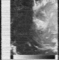
|
This is what an analog image transmission looks like.
Its single side band AM with the image data encoded as image tones varying from black at 1500 Hz and peak white at 2300 Hz.
Some black/white or grayscale calibration elements are usually present .
We know from Luna 9 that the Soviet system was similar. Don't know if some raw data exists for that, but perhaps it might help to clarify things.
* This information from Jodrell Bank about Luna 9 is helpful:
" The international facsimile standard is that the White/black transition corresponds to a a change in audio frequency between 1.5 to 2.3 kHz, while the Luna 9 transmissions used a change from 1.2 to 2.0 kHz. The difference in horizontal/vertical ratio was sometimes given as a factor 2 and sometimes as a factor 2.5 . The picture signals were transmitted on a subcarrier with maximum deviation of 2 kHz. The synchronization signal for the pictures (start of each line?) was a tone with the frequency 1.1 kHz (24). The lunar panoramas consisted of vertical lines with 500 elements (each 3.6 minutes of arc wide) and the 360 degree view around the horizon consisted of 6000 such lines"
(from http://www.jb.man.ac.uk/history/tracking/part2.html)
Posted by: Bjorn Jonsson Oct 21 2014, 08:23 PM
It would be interesting to reprocess this using modern computers and software by using the original data with full information on how the camera worked and how to reconstruct the signal. When data from other landers is processed it quickly becomes absolutely clear what you are looking at - you clearly see rocks etc. and in some cases parts of the landers. This is true for e.g. the Veneras, Huygens and various Mars and Lunar landers.
The problem with the images above is that even though advanced image processing methods have been used it is impossible to tell from the resulting images what you are really looking at and therefore impossible to tell whether the data you are processing is correctly reconstructed - there are too many "ifs" as 4th rock pointed out (inversion or no inversion, possible gain changes etc.). As I previously said, it would be interesting if the original data could somehow be recovered and all of the "ifs" eliminated with 100% certainty. If that is possible the result should be either an image that shows something recognizable (surface features like rocks and/or parts of the lander) or something looking like noise.
Posted by: nprev Oct 22 2014, 12:29 AM
Bjorn's points are valid, particularly the fact that the original data is not being used as the source for these permutations. Therefore, innumerable copying errors from various sources (format changes, transcription, etc.) have completely subsumed whatever signal there ever was--and there is considerable doubt that there ever was any in the first place--into noise.
Posted by: alex_k Jan 3 2015, 04:24 PM
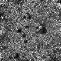
|
Here is an attempt to get 12x superresolution of Mars 3 landing site. For processing four HiRise images were used: ESP_031036_1345, PSP_061154_1345, ESP_032447_1345 and ESP_032737_1345. Details are very exaggerated. A Fourier-based algorithm was used, and the result was postprocessed by GIMP.
ADMIN NOTE: Take a look at http://www.unmannedspaceflight.com/index.php?showtopic=572&view=findpost&p=199723 on this from 2013. Plus the http://www.unmannedspaceflight.com/index.php?showtopic=572&view=findpost&p=199676.
Posted by: alex_k Jan 4 2015, 07:45 AM
[del]
ADMIN NOTE: Attempting to get an image and interpreting such from the Mars3 data http://www.unmannedspaceflight.com/index.php?showtopic=572&view=findpost&p=52475 in another topic (now merged with this one).
It is worth reading back through this entire topic to see what was discussed and how now we are just repeating ourselves. This is just adding 'noise'.
While conclusions varied from 'just noise' to 'possible image', the jury is sufficiently out until more complete/original data records can be sourced.
Therefore, it is recommended by the Admin/Mod team that no further image processing efforts be posted here from this point onwards.
If new, original source/raw data can be found and verified, then please bring it to the attention of the Forum or direct to specific members who are interested.
Posted by: alex_k Dec 2 2016, 11:17 AM
[del]
Posted by: alex_k Mar 18 2024, 05:09 AM
A recent https://spacedevice.ru/wp-content/uploads/2024/03/1.-Gektin-Kostachuk.pdf about processing Mars 3 signals (in Russian).
Yu.M. Gektin, Cand. Sci. (Engineering), contact @spacecorp.ru
Joint Stock Company Russian Space Systems, Moscow, Russian Federation
A.V. Kostachuk, Cand. Sci. (Engineering), contact@spacecorp.ru
Joint Stock Company Russian Space Systems, Moscow, Russian Federation
Abstract. The paper analyses signals from telephotometers installed on the lander of the Mars-3 space probe, which landed on the surface of Mars for the first time in the world in 1971. The duration of operation of the spacecraft transmitters is estimated, the imaging modes are analyzed, and the level of illumination at the landing site is determined. The geometrical characteristics of the images are substantiated based on the analysis of the received signals. A specialized algorithm is used to reconstruct fragments of panoramas transmitted by the lander and to carry out an overview analysis of these images. The historical value and significance of the results obtained are emphasized.
Keywords: Mars-3, signal analysis, image reconstruction
Powered by Invision Power Board (http://www.invisionboard.com)
© Invision Power Services (http://www.invisionpower.com)