Distant vistas, Endeavour, Iazu, and beyond |

  |
Distant vistas, Endeavour, Iazu, and beyond |
 Mar 5 2010, 10:58 PM Mar 5 2010, 10:58 PM
Post
#166
|
|
|
Member  Group: Senior Member Posts: 136 Joined: 8-August 06 Member No.: 1022 |
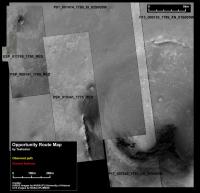
QUOTE (jamescanvin @ Mar 4 2010, 03:35 PM)  ngunn, I don't think the distant horizon can be part of Iazu, it just doesn't stretch that far east. Also, it looks more 'hazy' than the rest of Iazu. Looking at Google Mars it does suggest that we should have an horizon about 10km (ish) beyond Endeavour in that direction. Doug, I'd love to have a CTX base map of the area. Not sure how much time I'll have to do any further analysis, but here are some ID's of CTX images that would cover all of Endeavour and Iazu. P13_006135_1789_XN_01S005W P15_006847_1770_XN_03S005W P17_007849_1793_XN_00S005W Stu, Rui has named everything around here hasn't he?  James My personal favorite is P21_009141_1780_XI_02S005W_080708, because it was taken with a very small emission angle (and is thus nearly perfectly Nadir), and so high-frequency topography is least distorted in this image, compared to others. I'm working on a new CTX/HiRISE mosaic for my route mapping for the project, and put this CTX mosaic together some time ago (so it doesn't include much of Iazu). At least it's not so big I can't paste it here (I *think* >> edited to add, oops! It's an order of magnitude too big!). Scaled up to match the overlying HiRISE images in something like Photoshop, it's about 100GB, though! Fortunately, Arcmap and Global Mapper don't resample to match the scales. -Tim. |
 |
 
|
|
Mar 6 2010, 09:12 AM
Post
#167
|
||
|
Senior Member Group: Moderator Posts: 4279 Joined: 19-April 05 From: .br at .es Member No.: 253 |
I've been using most of these images on my route map version.
 Here's the top left part of it --the so called "context map"-- where I have labelled all background pictures.
There are three CTX images (from left to right: P01_001414_1780_XI_02S005W, P17_007849_1793_XN_00S005W, and P13_006135_1789_XN_01S005W) and basically two HiRISE images (PSP_009141_1780_RED and PSP_010341_1775_RED) plus a tiny bit of HiRISE ESP_011765_1780_RED to cover the area we're right now. Edit: Now I'm wondering that I should change the old "001414" image. It's the only one with an off-nadir pointing so it doesn't match so well with the other ones. |
|
|
|
|
|
|
Mar 6 2010, 12:14 PM
Post
#168
|
||
 The Poet Dude Group: Moderator Posts: 5551 Joined: 15-March 04 From: Kendal, Cumbria, UK Member No.: 60 |
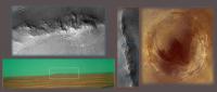
Just making some new slides for my next talk (thanks for the help, James!), thought some of you might find this useful in making sense of Oppy's horizon view...
Close up of those particular hills here... http://twitpic.com/16xi9m/full Crying out for the full 3D view treatment, I'd say...
-------------------- |
|
|
|
|
|
|
Mar 10 2010, 03:04 AM
Post
#169
|
|
|
Member Group: Senior Member Posts: 136 Joined: 8-August 06 Member No.: 1022 |
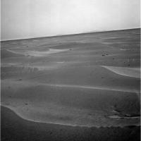
Bopolu on the horizon!
Amazing, since it's so far away. (about 65 km to center of the crater). -Tim. |
|
|
|
|
Mar 10 2010, 06:55 AM
Post
#170
|
|
|
Senior Member Group: Moderator Posts: 4279 Joined: 19-April 05 From: .br at .es Member No.: 253 |
Where, where! Oh, that's unfair Tim.
You have privileged access to the raw images. We here will have to wait for the next exploratorium update in about two hours. |
|
|
|
|
Mar 10 2010, 06:59 AM
Post
#171
|
|
|
The Poet Dude Group: Moderator Posts: 5551 Joined: 15-March 04 From: Kendal, Cumbria, UK Member No.: 60 |
Tim, that's just cruel.
-------------------- |
|
|
|
|
Mar 10 2010, 08:47 AM
Post
#172
|
|
|
Senior Member Group: Moderator Posts: 4279 Joined: 19-April 05 From: .br at .es Member No.: 253 |
QUOTE (tim53 @ Mar 10 2010, 04:04 AM) Bopolu on the horizon! Here it is!  (Click to enlarge) Ahh! I got my daily fix.
|
|
|
|
|
Mar 10 2010, 10:29 AM
Post
#173
|
|
|
Member Group: Members Posts: 890 Joined: 18-November 08 Member No.: 4489 |
nice but that is one noisy image
quick cleaning [attachment=21002:clean1.png] |
|
|
|
|
Mar 10 2010, 10:55 AM
Post
#174
|
|
 Member Group: Members Posts: 404 Joined: 5-January 10 Member No.: 5161 |
I kinda like the noisy image better. Seems the cleaned image has lost a lot of detail.
|
|
|
|
|
Mar 10 2010, 11:36 AM
Post
#175
|
|
 Special Cookie Group: Members Posts: 2168 Joined: 6-April 05 From: Sintra | Portugal Member No.: 228 |
QUOTE (Tesheiner @ Mar 10 2010, 08:47 AM) Here it is! Amazing! So many things to name so few words...guess I'll have to invent a new lexicon...
-------------------- "Ride, boldly ride," The shade replied, "If you seek for Eldorado!"
Edgar Alan Poe |
|
|
|
|
Mar 10 2010, 04:41 PM
Post
#176
|
|
|
Founder Group: Chairman Posts: 14431 Joined: 8-February 04 Member No.: 1 |
QUOTE (walfy @ Mar 10 2010, 10:55 AM) I kinda like the noisy image better. Seems the cleaned image has lost a lot of detail. FWIW - Calibrated images almost always have less noise than the raw JPG's. That 'detail' you're talking about is most likely noise that shouldn't even be there. |
|
|
|
|
Mar 10 2010, 06:14 PM
Post
#177
|
||
|
Solar System Cartographer Group: Members Posts: 10150 Joined: 5-April 05 From: Canada Member No.: 227 |
Here's a different version... worst noise removed and a tweak to the brightness.
Phil
-------------------- ... because the Solar System ain't gonna map itself.
Also to be found posting similar content on https://mastodon.social/@PhilStooke NOTE: everything created by me which I post on UMSF is considered to be in the public domain (NOT CC, public domain) |
|
|
|
|
|
|
Mar 10 2010, 06:19 PM
Post
#178
|
||
|
Solar System Cartographer Group: Members Posts: 10150 Joined: 5-April 05 From: Canada Member No.: 227 |
And a stretched version of the topography. Is there something very faint near the right edge?
Phil
-------------------- ... because the Solar System ain't gonna map itself.
Also to be found posting similar content on https://mastodon.social/@PhilStooke NOTE: everything created by me which I post on UMSF is considered to be in the public domain (NOT CC, public domain) |
|
|
|
|
|
|
Mar 10 2010, 10:11 PM
Post
#179
|
|
|
Member Group: Members Posts: 890 Joined: 18-November 08 Member No.: 4489 |
there is always a trade off between noise and detail
gmic dose a good job and so dose a fft and some of the noise is the jpg artifacts after fft showing the jpg [attachment=21011:Screenshot_2.png] My personal pet peev is the jpg artifacts .the jpg format should be illegal |
|
|
|
|
Mar 10 2010, 10:45 PM
Post
#180
|
|
|
Senior Member Group: Members Posts: 3516 Joined: 4-November 05 From: North Wales Member No.: 542 |
QUOTE (Phil Stooke @ Mar 10 2010, 06:19 PM) Is there something very faint near the right edge? Where's fredk? I think we already see that (and some tiny bits in between) in his post 104. |
|
|
|
|

|
Lo-Fi Version | Time is now: 24th April 2024 - 01:31 AM |
|
RULES AND GUIDELINES Please read the Forum Rules and Guidelines before posting. IMAGE COPYRIGHT |
OPINIONS AND MODERATION Opinions expressed on UnmannedSpaceflight.com are those of the individual posters and do not necessarily reflect the opinions of UnmannedSpaceflight.com or The Planetary Society. The all-volunteer UnmannedSpaceflight.com moderation team is wholly independent of The Planetary Society. The Planetary Society has no influence over decisions made by the UnmannedSpaceflight.com moderators. |
SUPPORT THE FORUM Unmannedspaceflight.com is funded by the Planetary Society. Please consider supporting our work and many other projects by donating to the Society or becoming a member. |
|