Santa Maria! |

  |
Santa Maria! |
 Mar 13 2011, 09:10 PM Mar 13 2011, 09:10 PM
Post
#631
|
|
|
Solar System Cartographer  Group: Members Posts: 10145 Joined: 5-April 05 From: Canada Member No.: 227 |
"Didn't they say that there was a shallow, salty sea way back near the start of the mission?"
Some people did say that, though not necessarily people on the mission. But Meridiani Planum is not a depression, there's no low area to hold a sea. It's been clear from day one that this couldn't have been a sea. Local puddles or lakes might allow ripples to create festoons (might... the idea they are caused by ripples is only a hypothesis), and I allowed for that in my comment. But check out ripples on a beach caused by sheet flow of water down the beach as the tide goes out and water in the sand leaks out. Linear flow of water under a snow or ice cover might also form ripples in places. There's no unambiguous evidence for bodies of open water, that I am aware of. But even if local ponds could form, there was no ocean here. Phil -------------------- ... because the Solar System ain't gonna map itself.
Also to be found posting similar content on https://mastodon.social/@PhilStooke NOTE: everything created by me which I post on UMSF is considered to be in the public domain (NOT CC, public domain) |
 |
 
|
|
Mar 13 2011, 10:59 PM
Post
#632
|
|
|
Senior Member Group: Members Posts: 2076 Joined: 13-February 10 From: Ontario Member No.: 5221 |
Thanks for clearing it up, I wasn't up to date on the current theories.
|
|
|
|
|
Mar 14 2011, 02:15 AM
Post
#633
|
|
 Member Group: Members Posts: 754 Joined: 9-February 07 Member No.: 1700 |
Endeavour crater has some low-lying areas.
 Interesting how precise one's wording needs to be when addressing an issue like this. Interesting how precise one's wording needs to be when addressing an issue like this.From a recent SDC article: "The Endeavour crater on Mars is a vast depression about 14 miles (22 km) wide. Opportunity has been heading for it since August 2008 because it will give scientists their deepest look yet into the surface of Mars. The goal is to study any clay deposits a sign of Martian water activity in the ancient past that may be present on Endeavour's rim, researchers have said." That's gonna be so fascinating! |
|
|
|
|
Mar 14 2011, 03:48 AM
Post
#634
|
|
|
Merciless Robot Group: Admin Posts: 8783 Joined: 8-December 05 From: Los Angeles Member No.: 602 |
Side note: as of this writing, this thread has had 100,035 views.
Seems to be a slight bit of interest here... 
-------------------- A few will take this knowledge and use this power of a dream realized as a force for change, an impetus for further discovery to make less ancient dreams real.
|
|
|
|
|
Mar 14 2011, 06:47 AM
Post
#635
|
|
 Senior Member Group: Members Posts: 2173 Joined: 28-December 04 From: Florida, USA Member No.: 132 |
In March of 2004, flush with the discoveries in Eagle Crater, Steve Squyres explored the idea of a Meridiani sea, even explaining away the lack of a depression to hold it.
"Even though it's flat and doesn't have a clear rim around it, things can erode away and the topography can change over time," Squyres responded.... "Now with respect to whether we are talking about water that was up to your neck ,or your ankles with briny pools or a deep sea, we'll have a better handle on that once we've explored this region over a larger area." A.J.S. Rayl: How, then, do they theorize, then, that Opportunity is parked on the shoreline? "The reason I feel good saying that is, in a situation like this, where you have evaporation taking place, all you have to do is sit in one place long enough and the water will come through," Squyres maintained. "In other words, the shoreline might be there and you're in deep water, but then it gets shallower and shallower and whoosh it goes by and you're sitting on dry stuff. And then it builds up with more water and the process repeats. We're talking about water that comes and goes and so the location of the shoreline will move with time." Therefore, he rationalizes, "at some point in time, it is likely that there was a shoreline here." http://www.planetary.org/news/2004/0323_Ma...ers_Update.html An abstract in the December 3, 2004 issue of Science is much more restrained in its wording: "We interpret the rocks to be a mixture of chemical and siliciclastic sediments formed by episodic inundation by shallow surface water, followed by evaporation, exposure, and desiccation." And the 'sea' has been reduced, in a December 17 Science article by Richard Kerr, to "...perhaps a vast puddle." Of course the press latched onto the romantic idea of Opportunity exploring an ancient shoreline, so it's perfectly understandable that that the idea of a shallow sea at Meridiani should remain in the public perception. It doesn't help that the NASA Science site still has at the end of its Opportunity page, "The evidence suggests that Opportunity’s landing site was once the shoreline of a salty sea." |
|
|
|
|
Mar 14 2011, 07:41 AM
Post
#636
|
|
 Member Group: Members Posts: 259 Joined: 23-January 05 From: Seattle, WA Member No.: 156 |
A lot can happen in 4.5 billion years, even on a world without plate tectonics. But I agree, if for no other reason than having looked at the wonderful MOLA maps, that it seems unlikely that Meridiani was a sea. But the sight of endless waves of sand rolling off into the distance still makes me want it to have been one. I remember seeing the first glimpse of the light rocks inside the rim of Endurance in the distance those years ago, thinking they were whitecaps, and Oppy's discarded parachute a wayward sail. Having sailed the ocean of space, it seemed only fit that Oppy land in a sea of sand that was once a sea of water, and that we would sail that dual sea with her, however briefly.
"The surface of the Earth is the shore of the cosmic ocean. On this shore, we've learned most of what we know. Recently, we've waded a little way out, maybe ankle-deep, and the water seems inviting." - Carl Sagan |
|
|
|
|
Mar 16 2011, 11:05 AM
Post
#637
|
||
|
Senior Member Group: Members Posts: 2816 Joined: 22-April 05 From: Ridderkerk, Netherlands Member No.: 353 |
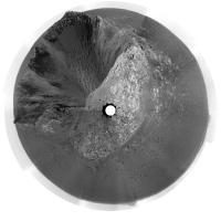
The Navcam view on Sol 2531.
Taken with the L0 Navcam. Jan van Driel
|
|
|
|
|
|
|
Mar 16 2011, 12:20 PM
Post
#638
|
||
|
Senior Member Group: Members Posts: 2816 Joined: 22-April 05 From: Ridderkerk, Netherlands Member No.: 353 |
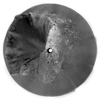
The last L0 image is complete down and
here is the complete L0 Navcam view taken on Sol 2525. Jan van Driel
|
|
|
|
|
|
|
Mar 16 2011, 02:01 PM
Post
#639
|
|
 The Poet Dude Group: Moderator Posts: 5551 Joined: 15-March 04 From: Kendal, Cumbria, UK Member No.: 60 |
Very nice, that's a heck of a view isn't it?
Going to miss Santa Maria, but looking forward to the journey ahead. -------------------- |
|
|
|
|
Mar 16 2011, 02:09 PM
Post
#640
|
|
 Senior Member Group: Admin Posts: 4763 Joined: 15-March 05 From: Glendale, AZ Member No.: 197 |
Very nice, lovely. Can we go now?
-------------------- If Occam had heard my theory, things would be very different now.
|
|
|
|
|
Mar 16 2011, 02:48 PM
Post
#641
|
|
 Senior Member Group: Members Posts: 4246 Joined: 17-January 05 Member No.: 152 |
We moved on 2538 to what I guess is the 2nd of the long-baseline imaging locations. If that's right, this'll be our last move before we hit the road again...
http://qt.exploratorium.edu/mars/opportuni...0M2.JPG?sol2538 |
|
|
|
|
Mar 16 2011, 04:59 PM
Post
#642
|
|||
|
Solar System Cartographer Group: Members Posts: 10145 Joined: 5-April 05 From: Canada Member No.: 227 |
Here are a couple of reprojected versions of jvandriel's most recent panoramas.
Phil
-------------------- ... because the Solar System ain't gonna map itself.
Also to be found posting similar content on https://mastodon.social/@PhilStooke NOTE: everything created by me which I post on UMSF is considered to be in the public domain (NOT CC, public domain) |
||
|
|
|
||
|
Mar 17 2011, 05:12 AM
Post
#643
|
|
 Member Group: Members Posts: 399 Joined: 28-August 07 From: San Francisco Member No.: 3511 |
Truly got to admire the patience of the MER team even though Endeavour beckons....
Great science, marvelous views and a healthy rover... thanks everyone for your (UMSF) Santa Maria memories. Southeast! -------------------- 'She drove until the wheels fell off...'
|
|
|
|
|
Mar 17 2011, 06:56 AM
Post
#644
|
|
|
Member Group: Members Posts: 754 Joined: 9-February 07 Member No.: 1700 |
onward!
 how many treks before the next surprise, I wonder blueberries perhaps? |
|
|
|
|
Mar 17 2011, 06:32 PM
Post
#645
|
|
|
The Poet Dude Group: Moderator Posts: 5551 Joined: 15-March 04 From: Kendal, Cumbria, UK Member No.: 60 |
Oppy looks back at Yuma...
http://twitpic.com/4aeapo/full (3D pic, red/blue glasses needed, not the shades you -------------------- |
|
|
|
|

|
Lo-Fi Version | Time is now: 16th April 2024 - 10:33 PM |
|
RULES AND GUIDELINES Please read the Forum Rules and Guidelines before posting. IMAGE COPYRIGHT |
OPINIONS AND MODERATION Opinions expressed on UnmannedSpaceflight.com are those of the individual posters and do not necessarily reflect the opinions of UnmannedSpaceflight.com or The Planetary Society. The all-volunteer UnmannedSpaceflight.com moderation team is wholly independent of The Planetary Society. The Planetary Society has no influence over decisions made by the UnmannedSpaceflight.com moderators. |
SUPPORT THE FORUM Unmannedspaceflight.com is funded by the Planetary Society. Please consider supporting our work and many other projects by donating to the Society or becoming a member. |
|