Further HiRISE imagery of Endeavour trek |

  |
Further HiRISE imagery of Endeavour trek |
 Dec 4 2008, 11:35 AM Dec 4 2008, 11:35 AM
Post
#1
|
|
|
Founder  Group: Chairman Posts: 14432 Joined: 8-February 04 Member No.: 1 |
Via James' find in the PDS
http://hirise.lpl.arizona.edu/PSP_010341_1775 And http://hirise.lpl.arizona.edu/PSP_010486_1775 Looks to me like once thru the current purgatoid/pavement area onto the Fram-crater-adjacent like terrain, it's smooth sailing, and by the time the purgatoids come back, we've got acres and acres of pavement for long drivers as well. Awesome  (Starting a new thread for discussion of imagery beyond that which we already had) |
 |
 
|
|
Dec 4 2008, 02:58 PM
Post
#2
|
|
 Senior Member Group: Admin Posts: 4763 Joined: 15-March 05 From: Glendale, AZ Member No.: 197 |
Now you've done it. Juramike isn't going to get any of his Christmas shopping done in time.
EDIT: Now that I look at these, I get the feeling that we're going to be there far ahead of the most optimistic predictions. -------------------- If Occam had heard my theory, things would be very different now.
|
|
|
|
|
Dec 4 2008, 03:25 PM
Post
#3
|
|
 Senior Member Group: Moderator Posts: 2262 Joined: 9-February 04 From: Melbourne - Oz Member No.: 16 |
Another nice surprise - I was under the impression that this new HiRISE image (PSP_010341_1775) didn't overlap with the ones we already had. But as I was adding terrain overlays onto Tim's map I realised that they do! So we now have the whole route from Victoria all the way to those amazing hills on the Endeavour rim.
-------------------- |
|
|
|
|
Dec 4 2008, 03:56 PM
Post
#4
|
||
|
Senior Member Group: Admin Posts: 4763 Joined: 15-March 05 From: Glendale, AZ Member No.: 197 |
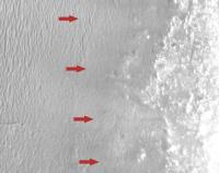
I noticed these image artifacts that appear to be part of the whole "pushbroom" scanning process (they match up with repeating patterns of lines across the larger image.) I had thought that this kind of stuff was cleaned up for the PDS, or have I got that wrong?
We have to be careful in the future because they look a whole lot like rover tracks.
Attached thumbnail(s)
-------------------- If Occam had heard my theory, things would be very different now.
|
|
|
|
|
|
|
Dec 4 2008, 04:12 PM
Post
#5
|
|
 Senior Member Group: Members Posts: 3648 Joined: 1-October 05 From: Croatia Member No.: 523 |
QUOTE (ElkGroveDan @ Dec 4 2008, 04:56 PM)  I noticed these image artifacts that appear to be part of the whole "pushbroom" scanning process (they match up with repeating patterns of lines across the larger image.) I had thought that this kind of stuff was cleaned up for the PDS, or have I got that wrong? A result of incomplete/insufficient calibration data, changing instrument behavior over time (such as degraded sensitivity in a couple of sensors) or just plain bad S/N ratio. It's probably far better than what it would look like without any calibration, but typically PDS releases aren't obliged to provide calibrated products at all. Cassini for example doesn't provide them yet. -------------------- |
|
|
|
|
Dec 4 2008, 04:54 PM
Post
#6
|
|
|
Member Group: Members Posts: 293 Joined: 22-September 08 From: Spain Member No.: 4350 |
QUOTE (ElkGroveDan @ Dec 4 2008, 04:56 PM) I noticed these image artifacts I think all HiRISE images have those stripes and seams. For example, they are visible when the darkness of the odd caves/vents is normalized. |
|
|
|
|
Dec 4 2008, 07:48 PM
Post
#7
|
|
|
Member Group: Members Posts: 530 Joined: 21-March 06 From: Canada Member No.: 721 |
This reminds me of when the turkey comes out at Thanksgiving. It gets real quiet as the masses turn their undivided attention to the bounty placed before them.
What can I say but clink-clink-clinkclinkclink-clinkclinkclinkclinkclink-CLINK-clinckclink... 
|
|
|
|
|
Dec 4 2008, 08:41 PM
Post
#8
|
|
|
Senior Member Group: Moderator Posts: 4279 Joined: 19-April 05 From: .br at .es Member No.: 253 |
It's just me or is the HiRISE server down right now?
 
|
|
|
|
|
Dec 4 2008, 09:16 PM
Post
#9
|
|
|
Founder Group: Chairman Posts: 14432 Joined: 8-February 04 Member No.: 1 |
It's OK from here.
|
|
|
|
|
Dec 4 2008, 09:41 PM
Post
#10
|
|
 Member Group: Members Posts: 710 Joined: 28-September 04 Member No.: 99 |
QUOTE (ElkGroveDan @ Dec 4 2008, 04:56 PM) I noticed these image artifacts that appear to be part of the whole "pushbroom" scanning process. Those artifacts seem to be more noticable in this image than in others from Meridiani. Compare with these: http://hirise.lpl.arizona.edu/PSP_009497_1770 http://hirise.lpl.arizona.edu/PSP_009009_1815 I suspect because of atmospheric haze/dust the image was a bit bland and the stretching process just enhanced the noise. |
|
|
|
|
Dec 4 2008, 10:11 PM
Post
#11
|
|
 The Poet Dude Group: Moderator Posts: 5551 Joined: 15-March 04 From: Kendal, Cumbria, UK Member No.: 60 |
Excellent new images! I had great fun playing about with them on the IAS Viewer, and made some lovely crops. I was going to post them here but they're so big it would take up too much room, so I thought "What the heck, I'll just start another blog..." (easier than setting up a photo gallery), and you can find the pics there, if you want a look. Comments on what the images actually show (geologically) appreciated, and feel free to link to / reproduce the images here.
http://roadtoendeavour.wordpress.com -------------------- |
|
|
|
|
Dec 4 2008, 11:49 PM
Post
#12
|
|
 Senior Member Group: Members Posts: 1887 Joined: 20-November 04 From: Iowa Member No.: 110 |
QUOTE (Tesheiner @ Dec 4 2008, 02:41 PM) It's just me or is the HiRISE server down right now? I've been having that problem off and on for HiRISE site and some other U of Arizona sites, for example the CICLOPS and the Mars Phoenix sites too. |
|
|
|
|
Dec 6 2008, 07:32 AM
Post
#13
|
|
|
The Poet Dude Group: Moderator Posts: 5551 Joined: 15-March 04 From: Kendal, Cumbria, UK Member No.: 60 |
I've put some colourisations of areas cropped from the recently-found HiRISE images up on my Endeavour blog, if anyone wants a look...
http://roadtoendeavour.wordpress.com/2008/...for-some-colour (I know not all the images link to full size versions, I'll correct that when I get home) -------------------- |
|
|
|
|
Dec 8 2008, 08:23 PM
Post
#14
|
|
|
The Poet Dude Group: Moderator Posts: 5551 Joined: 15-March 04 From: Kendal, Cumbria, UK Member No.: 60 |
Has anyone else been looking at the new HiRISE images and wondering where Oppy will go once she reaches the hills?
I've put down some thoughts on my Endeavour piccies blog. Where would you drive Oppy, if you had the keys..?
-------------------- |
|
|
|
|
Dec 9 2008, 12:07 AM
Post
#15
|
||
|
Senior Member Group: Admin Posts: 4763 Joined: 15-March 05 From: Glendale, AZ Member No.: 197 |
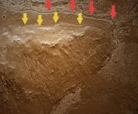
QUOTE (Stu @ Dec 8 2008, 12:23 PM) Where would you drive Oppy, if you had the keys..? That's easy Stu. I expect we'll spend a lot of time around the apron and initial rise of these hills. It's clear from the HRISE images that there is a contact zone (or several) between the Meridiani substrata we've been examining these past few years (for argument's sake let's call it seabed or lake bottom) and the much older hills that may never have been submerged. Dare I call them islands? Dare I suggest we will see Opportunity examining an ancient shoreline ? So while I am positive there are some nice ancient outcrops in those highlands, I want to see what may have been the shores of Endeavor Island at the center of Lake Meridiani.
Attached thumbnail(s)
-------------------- If Occam had heard my theory, things would be very different now.
|
|
|
|
|
|
|

|
Lo-Fi Version | Time is now: 29th April 2024 - 07:59 PM |
|
RULES AND GUIDELINES Please read the Forum Rules and Guidelines before posting. IMAGE COPYRIGHT |
OPINIONS AND MODERATION Opinions expressed on UnmannedSpaceflight.com are those of the individual posters and do not necessarily reflect the opinions of UnmannedSpaceflight.com or The Planetary Society. The all-volunteer UnmannedSpaceflight.com moderation team is wholly independent of The Planetary Society. The Planetary Society has no influence over decisions made by the UnmannedSpaceflight.com moderators. |
SUPPORT THE FORUM Unmannedspaceflight.com is funded by the Planetary Society. Please consider supporting our work and many other projects by donating to the Society or becoming a member. |
|