Phoenix - spring images, HiRISE views of Phoenix after the long, long winter |

  |
Phoenix - spring images, HiRISE views of Phoenix after the long, long winter |
 Nov 2 2009, 06:22 PM Nov 2 2009, 06:22 PM
Post
#31
|
|
|
Newbie  Group: Members Posts: 13 Joined: 23-March 08 Member No.: 4072 |
OK. I was wrong at all. Efectively, the image I mentioned was Hale crater, taken in 2007. One less science mystery for me
 and realized there's no recent HiRISE images and realized there's no recent HiRISE images  Thanks Greg, imipak and Emily. |
 |
 
|
|
Nov 3 2009, 01:09 PM
Post
#32
|
||
 Senior Member Group: Members Posts: 1452 Joined: 26-July 08 Member No.: 4270 |
Here's to wishing re-established contact with Phoenix.
I was bored...
Attached thumbnail(s)
-------------------- -- Hungry4info (Sirius_Alpha)
|
|
|
|
|
|
|
Nov 3 2009, 09:02 PM
Post
#33
|
|
|
Member Group: Members Posts: 507 Joined: 10-September 08 Member No.: 4338 |
Upcoming colloquium talk at the SETI Institute:
02/24/2010 Latest results from the Mars Phoenix Lander Microscope John Marshall, SETI Institute Presumably, these are anticipated results after regaining contact! 
|
|
|
|
|
Nov 5 2009, 09:24 AM
Post
#34
|
|
|
Senior Member Group: Members Posts: 2922 Joined: 14-February 06 From: Very close to the Pyrénées Mountains (France) Member No.: 682 |
Did we see this one?: http://www.spaceflightnow.com/news/n0911/04phoenix/
-------------------- |
|
|
|
|
Nov 5 2009, 09:58 AM
Post
#35
|
|
|
Founder Group: Chairman Posts: 14434 Joined: 8-February 04 Member No.: 1 |
I'm assuming it's the same image Phil used.
|
|
|
|
|
Nov 5 2009, 10:10 AM
Post
#36
|
|
 Senior Member Group: Members Posts: 3648 Joined: 1-October 05 From: Croatia Member No.: 523 |
QUOTE (djellison @ Nov 5 2009, 10:58 AM)  I'm assuming it's the same image Phil used. But now it's available in Technicolor™! -------------------- |
|
|
|
|
Nov 5 2009, 11:47 AM
Post
#37
|
|
|
Solar System Cartographer Group: Members Posts: 10229 Joined: 5-April 05 From: Canada Member No.: 227 |
Yes, same one, and it was in Emily's animation.
Phil -------------------- ... because the Solar System ain't gonna map itself.
Also to be found posting similar content on https://mastodon.social/@PhilStooke Maps for download (free PDF: https://upload.wikimedia.org/wikipedia/comm...Cartography.pdf NOTE: everything created by me which I post on UMSF is considered to be in the public domain (NOT CC, public domain) |
|
|
|
|
Nov 5 2009, 03:13 PM
Post
#38
|
|
 Senior Member Group: Admin Posts: 4763 Joined: 15-March 05 From: Glendale, AZ Member No.: 197 |
QUOTE Mars Reconnaissance Orbiter has spotted the Phoenix lander encased in dry ice in the depths of winter on the northern polar plains of Mars I don't know that I would call it "encased." That patchy setting looks a lot like my Phoenix Christmas card from last year (minus the firewood of course). -------------------- If Occam had heard my theory, things would be very different now.
|
|
|
|
|
Nov 5 2009, 03:18 PM
Post
#39
|
|
|
Solar System Cartographer Group: Members Posts: 10229 Joined: 5-April 05 From: Canada Member No.: 227 |
So there actually were two images, July and August - I didn't know that before. The frost patches differ a bit, but it would be possible to combine the two images for a 'super-resolution' or noise-reduced view.
Phil -------------------- ... because the Solar System ain't gonna map itself.
Also to be found posting similar content on https://mastodon.social/@PhilStooke Maps for download (free PDF: https://upload.wikimedia.org/wikipedia/comm...Cartography.pdf NOTE: everything created by me which I post on UMSF is considered to be in the public domain (NOT CC, public domain) |
|
|
|
|
Nov 10 2009, 05:43 PM
Post
#40
|
|
 Senior Member Group: Members Posts: 4256 Joined: 17-January 05 Member No.: 152 |
Curious story from Sky and Telescope. First the writer states:
QUOTE The view here gives the impression of frosty patches atop ice-free ground, but that's an artifact of contrast enhancement. In fact, the entire scene is covered with frozen carbon dioxide. What makes him say that? Why would there be such well-defined brighter patches if the ground was completely covered? The brighter patches don't look like south-facing slopes illuminated by the low Sun - there aren't the corresponding darker areas that you'd expect for the north facing slopes. Besides, I read that the Sun was only at one degree elevation for these images. As we know, the direct, directional illumination from the Sun would be severely attenuated by atmospheric dust when the Sun is that low. Most of the illumination would be diffuse illumination from the sky, which shouldn't produce much contrast on slopes. Could the CO2 be continuous, but dust is covering much of the CO2, with the bright areas free of dust? The writer also states: QUOTE We'll probably never know how just how much CO2 snow accumulated atop the lander by September, when the coating was likely thickest That surprized me a bit, since spring equinox was October 26th, and with Phoenix only a few degrees north of the arctic circle, it should've been getting quite a lot of sunlight by September. But still I could believe that the July and August images show essentially the maximum amount of CO2 coverage. So maybe that's what he bases his claim on that the coverage is complete in the images? |
|
|
|
|
Nov 10 2009, 05:57 PM
Post
#41
|
|
 Senior Member Group: Members Posts: 2173 Joined: 28-December 04 From: Florida, USA Member No.: 132 |
QUOTE (fredk @ Nov 10 2009, 12:43 PM) ....Most of the illumination would be diffuse illumination from the sky, which shouldn't produce much contrast on slopes. It looks to me like the distinctive surface polygons are present in the dark areas but not visible in the bright areas. If the dark areas were a layer of CO2 covered by a layer of dust, they should be as smooth and featureless as the bright areas. Could the CO2 be continuous, but dust is covering much of the CO2, with the bright areas free of dust?... My question is, are the bright areas flat patches of frost or thicker drifts. If the light is entirely diffused, it may be impossible to tell anything by looking for shadows around the lander. |
|
|
|
|
Nov 11 2009, 05:01 PM
Post
#42
|
|
 Martian Photographer Group: Members Posts: 353 Joined: 3-March 05 Member No.: 183 |
The coldest temperatures occurred/ended at the very end of July, based on past years' TES data. Sublimation will not exceed deposition at the minimum, but rather some time later. The temperatures come up quickly (probably with a feedback involving loss of CO2 ice), so August or maybe September is reasonable. I was surprised too, so I checked. But I imagine no substantive difference from the last image to any other image until the ice starts substantially disappearing.
My impression is the images show icy areas and non-icy areas. But, that's an impression based on an imaged stretched in ways I don't know. It could as easily be thick ice with ice or frost thin enough that the underlying soil influences the albedo. It is, in any case, an albedo contrast. I say that, not because the Sun is so low, but because you can do photoclinometry on the image. The darker areas show their topography quite clearly--I can see features Phoenix saw more clearly than in the orbiter images during the mission (although not as well as the latest pre-dark images). In my opinion, you can even see shading/brightening at the margins of the bright patches. I suggest they are likely just thicker accumulations (ie, drifts). Further, it seems that troughs appear icier than ridges. When the Sun is very low or below the horizon, diffuse light dominates completely. But twilight skies are not even close to perfectly diffuse, and most of the light comes from 10-20 deg elevation at the solar azimuth +- 20 degrees or so (depends on exact conditions). Some USGS people have done shape from shading on orbiter images of twilit areas, IIRC. |
|
|
|
|
Nov 14 2009, 02:26 PM
Post
#43
|
||
 Senior Member Group: Members Posts: 1089 Joined: 19-February 05 From: Close to Meudon Observatory in France Member No.: 172 |
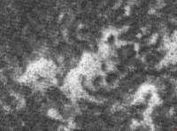
 For your perusal, here is an high resolution picture showing the Phoenix lander during winter, made from the sum-up of MRO's images ESP_014103_2485_RED.NOMAP.jp2 and ESP_014393_2485_RED.NOMAP.jp2 . For your perusal, here is an high resolution picture showing the Phoenix lander during winter, made from the sum-up of MRO's images ESP_014103_2485_RED.NOMAP.jp2 and ESP_014393_2485_RED.NOMAP.jp2 .It seems that the lander has lost its "symmetrical" look... (a damaged/collapsed solar panel ?) and that this effect is real and not a processing artifact.
|
|
|
|
|
|
|
Nov 14 2009, 02:39 PM
Post
#44
|
|
|
Member Group: Members Posts: 877 Joined: 7-March 05 From: Switzerland Member No.: 186 |
A high resolution comparison in addition would be nice now
-------------------- |
|
|
|
|
Nov 14 2009, 02:52 PM
Post
#45
|
|
|
Founder Group: Chairman Posts: 14434 Joined: 8-February 04 Member No.: 1 |
Super resolution isn't really going to work with two push broom images. You're likely introducing more artefacts than improvements. It looks less sharp and phoenix less obvious than the orig two images I'm afraid. So drawing any conclusion from it is unwise
|
|
|
|
|

|
Lo-Fi Version | Time is now: 26th September 2024 - 11:52 PM |
|
RULES AND GUIDELINES Please read the Forum Rules and Guidelines before posting. IMAGE COPYRIGHT |
OPINIONS AND MODERATION Opinions expressed on UnmannedSpaceflight.com are those of the individual posters and do not necessarily reflect the opinions of UnmannedSpaceflight.com or The Planetary Society. The all-volunteer UnmannedSpaceflight.com moderation team is wholly independent of The Planetary Society. The Planetary Society has no influence over decisions made by the UnmannedSpaceflight.com moderators. |
SUPPORT THE FORUM Unmannedspaceflight.com is funded by the Planetary Society. Please consider supporting our work and many other projects by donating to the Society or becoming a member. |
|