Opportunity Route Map |

  |
Opportunity Route Map |
 Jul 11 2006, 04:01 PM Jul 11 2006, 04:01 PM
Post
#1651
|
||
|
Senior Member  Group: Moderator Posts: 4279 Joined: 19-April 05 From: .br at .es Member No.: 253 |
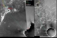
Updated route map (sol 875)
|
|
 |
 
|
|
|
Jul 11 2006, 06:57 PM
Post
#1652
|
|
 Member Group: Members Posts: 133 Joined: 3-June 06 From: the jungle of Nool Member No.: 799 |
Er, Tesheiner, did you check Ft Gibson size from the Navcam images yet?
My parallax measurments are: to furtherest outcrop exposure north of Oppy is 32.4 m +/- 2.0; to furtherest outcrop exposure south of Oppy 6.3 +/- 0.1 . I chose to use the northern-most visible block as the start of the feature, reasoning that from orbit even a few patchy blocks will show up very bright. so the outcrop is 38.7 +/- 2.1 meters long. Looking at the feature I think the faint white area to the south of your sol 869 position is the southern end of the feature. More troubling are the parallax measurments to the nearest outcrop from the current ( sol 875 ) position: I measure 14.5 +/- 0.1 meters to the nearest outcrop and 25.8 +/- 0.3 to the other side -- for a width of 11.3 meters. There is a fairly large dune ripple down the center. I think that Oppy is about 13 meters further south and a few meters west from your current position. |
|
|
|
|
Jul 11 2006, 08:15 PM
Post
#1653
|
|
|
Senior Member Group: Moderator Posts: 4279 Joined: 19-April 05 From: .br at .es Member No.: 253 |
I saw the north looking images but didn't have time to double-check that sol's position; I'll do that tomorrow.
Those outcrops are good opportunities to sync' the map. |
|
|
|
|
Jul 11 2006, 08:54 PM
Post
#1654
|
|
|
Senior Member Group: Members Posts: 2919 Joined: 14-February 06 From: Very close to the Pyrénées Mountains (France) Member No.: 682 |
QUOTE (Tesheiner @ Jul 2 2006, 09:45 PM)  I would try a similar aproach as for Spirit. You must find similar features (e.g. rocks) on both pre and post-drive images and calculate the net driving distance using any Parallax Calculator. For the driving heading I would take the beacon as a reference. This approach, together with periodic corrections (if possible), worked quite well for Spirit's route map. If the apron is as smooth as "we" suppose it is, "they"'ll probably head very stait to a dirrection and keep it till VC. So when we'll know the heading, counting weels turns/marks will also help knowing where we are. QUOTE (Tesheiner @ Jul 2 2006, 09:45 PM) My summer vacations starts on Jul 15th and I'm quite sure by that time we will still be at Beagle Crater. ...you'll be back for VC arrival on Sol 935. 
-------------------- |
|
|
|
|
Jul 11 2006, 09:18 PM
Post
#1655
|
|
|
Senior Member Group: Moderator Posts: 4279 Joined: 19-April 05 From: .br at .es Member No.: 253 |
QUOTE (climber @ Jul 11 2006, 10:54 PM) So when we'll know the heading, counting weels turns/marks will also help knowing where we are. The problem is that rear-looking navcams are not always taken and take quite a long time to be downlinked; and using hazcam pics to count wheel marks is only doable for short drives. |
|
|
|
|
Jul 11 2006, 09:46 PM
Post
#1656
|
|
 Member Group: Members Posts: 578 Joined: 5-November 04 From: Denmark Member No.: 107 |
Who cares? The apron will after all be crossed in two days
 (Or it could be) 
-------------------- "I want to make as many people as possible feel like they are part of this adventure. We are going to give everybody a sense of what exploring the surface of another world is really like"
- Steven Squyres |
|
|
|
|
Jul 12 2006, 04:38 PM
Post
#1657
|
||
|
Senior Member Group: Moderator Posts: 4279 Joined: 19-April 05 From: .br at .es Member No.: 253 |
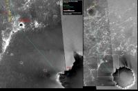
Updated route map (sol 876)
Horton, I did some re-adjustments on positions 869-875. Have a look on them. |
|
|
|
|
|
|
Jul 12 2006, 07:22 PM
Post
#1658
|
|
|
Member Group: Members Posts: 133 Joined: 3-June 06 From: the jungle of Nool Member No.: 799 |
Definitely looks better to me.
I measured the distance to the center of the dune crest down the center of the outcrop to be about 11 meters from Oppy and then drew a line parallel to the dune center 11 meters from the center. I then measured 19 meters to the southernmost visible end of the outcrop -- and 33 meters to the edge of the small crater to the south. the arcs from these two points intersect the 11 meter dune line at about the same point -- about 5 meters to the south-west of your position. Of course -- as always -- this assumes I am actually seeing corresponding points on the map. |
|
|
|
|
Jul 12 2006, 11:25 PM
Post
#1659
|
|
|
Junior Member Group: Members Posts: 46 Joined: 14-January 06 Member No.: 645 |
QUOTE (dot.dk @ Jul 11 2006, 09:46 PM) Who cares? The apron will after all be crossed in two days I've been looking at the route map for some time and I just can't see oppy making a beeline for Victoria's rim. Wouldn't it make more sense to "connect the dots" visiting the two small "waypoint" craters in the apron along the way to the rim? |
|
|
|
|
Jul 13 2006, 01:07 PM
Post
#1660
|
||
|
Senior Member Group: Moderator Posts: 4279 Joined: 19-April 05 From: .br at .es Member No.: 253 |
Updated route map (sol 877)
|
|
|
|
|
|
|
Jul 13 2006, 01:42 PM
Post
#1661
|
|
 Special Cookie Group: Members Posts: 2168 Joined: 6-April 05 From: Sintra | Portugal Member No.: 228 |
-------------------- "Ride, boldly ride," The shade replied, "If you seek for Eldorado!"
Edgar Alan Poe |
|
|
|
|
Jul 13 2006, 05:00 PM
Post
#1662
|
|
 Member Group: Members Posts: 547 Joined: 1-May 06 From: Scotland (Ecosse, Escocia) Member No.: 759 |
QUOTE (climber @ Jul 11 2006, 09:54 PM) If the apron is as smooth as "we" suppose it is, "they"'ll probably head very stait to a dirrection and keep it till VC. So when we'll know the heading, counting weels turns/marks will also help knowing where we are. I don't think the apron is remotely smooth. We can see from Tesh's photo-map and from the recent surface pan cams that it is covered in dunes, at least in the area above the white "scarp", behind (south of) Beagle Crater. Kenny |
|
|
|
|
Jul 13 2006, 05:06 PM
Post
#1663
|
|
|
Member Group: Members Posts: 133 Joined: 3-June 06 From: the jungle of Nool Member No.: 799 |
QUOTE (Tesheiner @ Jul 13 2006, 09:07 AM) Updated route map (sol 877) I agree with your 877 position -- but not the 876 position. I measured a change in position of 24 meters +/- 1 meter, using a number of before / after move pancam points. Curiously, where you place the "kink" agrees with my 876 position... I always do my position calculations before I look at yours and it is reassuring when they are the same -- and distressing when they are not. Now that we are again in a "feature rich" area, there should be no more differences. |
|
|
|
| Guest_Sunspot_* |
Jul 13 2006, 05:20 PM
Post
#1664
|
|
Guests |
QUOTE (kenny @ Jul 13 2006, 06:00 PM) I don't think the apron is remotely smooth. We can see from Tesh's photo-map and from the recent surface pan cams that it is covered in dunes, at least in the area above the white "scarp", behind (south of) Beagle Crater. Kenny i dont think those pics are aimed directly at the apron around the crater..... |
|
|
|
|
Jul 13 2006, 09:03 PM
Post
#1665
|
|||
|
Senior Member Group: Moderator Posts: 4279 Joined: 19-April 05 From: .br at .es Member No.: 253 |
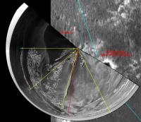
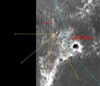
QUOTE (hortonheardawho @ Jul 13 2006, 07:06 PM) I agree with your 877 position -- but not the 876 position. I measured a change in position of 24 meters +/- 1 meter, using a number of before / after move pancam points. Curiously, where you place the "kink" agrees with my 876 position... I always do my position calculations before I look at yours and it is reassuring when they are the same -- and distressing when they are not. Now that we are again in a "feature rich" area, there should be no more differences. I pinpointed sol 876 position with the help of a polar projection; that's what I usually do when we are at/near outcrop rich areas. Here you have two images of the process. The first is the polar projection and some heading lines (in yellow) to a set of reference features (cyan points); the yellow points are placed at the actual location of those features, as measured by parallax (AlgorimancerPG tool). The second image is the same thing but the polar projection's layer hidden. To locate the referred sol's position, the trick is to move the heading lines' layer until the points fit with the background map image. The second image has the headings layer actually located at what I believe is the "best fit" position.
|
||
|
|
|
||
|

|
Lo-Fi Version | Time is now: 23rd April 2024 - 05:26 PM |
|
RULES AND GUIDELINES Please read the Forum Rules and Guidelines before posting. IMAGE COPYRIGHT |
OPINIONS AND MODERATION Opinions expressed on UnmannedSpaceflight.com are those of the individual posters and do not necessarily reflect the opinions of UnmannedSpaceflight.com or The Planetary Society. The all-volunteer UnmannedSpaceflight.com moderation team is wholly independent of The Planetary Society. The Planetary Society has no influence over decisions made by the UnmannedSpaceflight.com moderators. |
SUPPORT THE FORUM Unmannedspaceflight.com is funded by the Planetary Society. Please consider supporting our work and many other projects by donating to the Society or becoming a member. |
|