Lakes in the limelight, the 2013 image bonanza continues |

  |
Lakes in the limelight, the 2013 image bonanza continues |
 Aug 21 2014, 01:54 AM Aug 21 2014, 01:54 AM
Post
#46
|
||
|
Member  Group: Members Posts: 699 Joined: 1-April 08 From: Minnesota ! Member No.: 4081 |
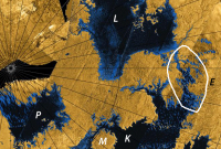
I presume this is the estuary (E) connecting Ligeia mare (L) and Kraken mare (K).
|
|
 |
 
|
|
|
Aug 21 2014, 01:29 PM
Post
#47
|
|
 Senior Member Group: Moderator Posts: 2785 Joined: 10-November 06 From: Pasadena, CA Member No.: 1345 |
Yup.
See: Sotin et al., Icarus 221 (2012) 768786. "Observations of Titans Northern lakes at 5[microns]: Implications for the organic cycle and geology". doi: 0.1016/j.icarus.2012.08.017. Freely available here: http://www.barnesos.net/publications/paper...thern.Lakes.pdf (Thanks to Jason Barnes for making this available on his webpage.) -------------------- Some higher resolution images available at my photostream: http://www.flickr.com/photos/31678681@N07/
|
|
|
|
|
Aug 21 2014, 10:07 PM
Post
#48
|
|
|
Senior Member Group: Members Posts: 3516 Joined: 4-November 05 From: North Wales Member No.: 542 |
Thanks for that confirmation of what is meant by 'the estuary'. Actually there seem to be quite a lot of estuaries draining into Kraken Mare, mostly at its northern end from what we've seen so far. The paper you refer to explicitly leaves as a significant open question the relative levels of Kraken and Ligeia, hence my interest in whether the current flyby science activities aim to address this.
|
|
|
|
|
Aug 22 2014, 09:23 PM
Post
#49
|
|
 Member Group: Members Posts: 754 Joined: 9-February 07 Member No.: 1700 |
When Cassini first arrived at Saturn, the release of Huygens was delayed (to get a better angle for comm relay, IIRC). I wondered why not delay it for many orbits so a landing site could be chosen based on the better info being obtained from numerous Titan flybys. Prudence favored releasing the lander as soon as possible.
A question for our Titan experts: if Cassini were still carrying Huygens today, where (and when) on Titan would you want to have it land? |
|
|
|
|
Aug 22 2014, 09:42 PM
Post
#50
|
|
|
Senior Member Group: Members Posts: 3516 Joined: 4-November 05 From: North Wales Member No.: 542 |
QUOTE (brellis @ Aug 22 2014, 10:23 PM)  if Cassini were still carrying Huygens today, where (and when) on Titan would you want to have it land? (No expert, but I do have opinions .  ) )I'm really glad nobody had the chance to choose the site. It landed with exceptional good fortune in a very information-rich location which would never in a month of Sundays have been selected by cautious planners. But yes: now we know what we know, and what we know is we badly need a robotic chemist in one of the lakes. Huygens was designed to cope with a lake landing but it wouldn't have done much chemistry. |
|
|
|
|
Aug 23 2014, 06:59 AM
Post
#51
|
|
|
Senior Member Group: Members Posts: 3516 Joined: 4-November 05 From: North Wales Member No.: 542 |
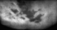
At first sight there appears to be a line of cloud in much the same place as before in this new image (on the far right just above Ligeia Lacus): http://saturn.jpl.nasa.gov/multimedia/imag...5/N00228346.jpg
|
|
|
|
|
Aug 23 2014, 04:03 PM
Post
#52
|
||
 Lord Of The Uranian Rings Group: Members Posts: 798 Joined: 18-July 05 From: Plymouth, UK Member No.: 437 |
Yep, there seems to be a cloud right between Muggel and Ligeia, alright.
-------------------- |
|
|
|
|
|
|
Sep 1 2014, 12:36 AM
Post
#53
|
|
 Member Group: Members Posts: 610 Joined: 23-February 07 From: Occasionally in Columbia, MD Member No.: 1764 |
QUOTE (ngunn @ Aug 22 2014, 04:42 PM) I'm really glad nobody had the chance to choose the site. It landed with exceptional good fortune in a very information-rich location which would never in a month of Sundays have been selected by cautious planners..... Huygens was designed to cope with a lake landing but it wouldn't have done much chemistry. Yes, and no. The entry point was determined by a number of engineering factors (entry angle tolerable by heat shield defines a circle, given the delivery asymptote). Solar illumination for the descent spectral measurements, and communications geometry (including having the line of sight mostly east-west for doppler wind measurements) were also constraints. These determined a small entry region around 145W 20N. This site was targeted by VIMS on the first Titan flyby (and hence had the first Nature paper written about it). The feature that happened to be at that spot, now named Tortola Facula, although I nicknamed it the 'cat poo', was possibly overinterpreted as a cryovolcanic construct - I think observations since do not lend much support to that interpretation. When the Huygens mission had to be redesigned following the receiver design flaw discovered on the Earth flyby in 1999, the new delivery scenario actually relieved some of the communications constraints on the delivery point, and we actually had a choice of 2 sites (and now, circa 2002 IIRC, crude maps to think about) at 190W and 10 North or South. We actually discussed it and South won, because it was the border between near-IR (940nm) bright and dark stuff. 940nm data, even at this point, don't really discriminate photometrically between dunes and seas, and no-one really expected the former! (By this time the observation planning had moved to later in the tour, and the VIMS targeting of the old landing site remained unchanged..) Anyway, had the probe landed in a liquid, it might well have capsized depending on the wind (the payload was indeed designed mostly with a liquid landing in mind, but the probe itself had no design requirements for any landing). The GCMS inlet was heated with the intent of volatilizing surface material, which indeed occurred in the damp regolith we landed in. So it might have been quite interesting chemistry-wise. Obviously, we might well aim for the seas now, although they might in fact be of quite different composition. Ligeia looks to be rather methane-rich ('fresh') while Kraken may be more solute-rich (analogous to the Baltic and the North Sea, or the Black Sea and the Mediterranean) - see http://www.lpl.arizona.edu/~rlorenz/flushing_preprint.pdf A sonar would probably work better in Ligeia, but from a chemistry standppoint Kraken might be the preferred choice. To understand the hydrological cycle you'd probably want a lander for each, or a vehicle that could somehow sample both...... Anyway, I take your point. If you want to survive a landing, a gullied streambed would likely not be the best choice. If we knew the surface, would we have aimed for the dunefields (as we did in the 2007 APL Titan Explorer Flagship Mission Study, before the seas had been mapped) ? Or the midlatitude blandlands? If we knew the seas were there, would we have targeted them - perhaps not - remember they were in winter darkness in 2005 ! Indeed where we ended up was information-rich - it certainly showed instantly that Titan was a hydrologically-shaped world. |
|
|
|
|
Sep 1 2014, 11:54 AM
Post
#54
|
|
|
Senior Member Group: Members Posts: 3516 Joined: 4-November 05 From: North Wales Member No.: 542 |
QUOTE (rlorenz @ Sep 1 2014, 01:36 AM) from a chemistry standppoint Kraken might be the preferred choice. Perhaps specifically the southern basin of Kraken given the drainage scheme you postulate there? I note that it lies partly outside Titan's arctic circle so would receive at least some sunlight even in midwinter. I don't know if the same can be said for the possibility of direct-to-earth communications |
|
|
|
|
Sep 1 2014, 01:40 PM
Post
#55
|
|
|
Member Group: Members Posts: 610 Joined: 23-February 07 From: Occasionally in Columbia, MD Member No.: 1764 |
QUOTE (ngunn @ Sep 1 2014, 07:54 AM) Perhaps specifically the southern basin of Kraken given the drainage scheme you postulate there? I note that it lies partly outside Titan's arctic circle so would receive at least some sunlight even in midwinter. I don't know if the same can be said for the possibility of direct-to-earth communications There it comes down to a 'how little data will you accept and how much risk of terrain obstruction' question. The usual story of contemporary planetary exploration - anything is possible, but how do you prove that there is no way, at all, ever, that it could possibly go wrong... Arguably at the extreme south of Kraken (ditto at Ontario) the material is more likely to be muddy/viscous, which makes landing dynamics and material sampling harder to test/verify (again, chances are everything would be fine, just costs a lot to demonstrate..) |
|
|
|
|
Sep 4 2014, 02:44 AM
Post
#56
|
|
|
Member Group: Members Posts: 699 Joined: 1-April 08 From: Minnesota ! Member No.: 4081 |
QUOTE (rlorenz @ Aug 31 2014, 06:36 PM) Obviously, we might well aim for the seas now, although they might in fact be of quite different composition. and this paper in Icarus http://www.jpl.nasa.gov/news/news.php?release=2014-294 might help explain sea composition differences if some seas are much older and therefore alkanofers and clathrate composition changes and interactions can influence extant sea composition. |
|
|
|
|
Sep 5 2014, 03:58 PM
Post
#57
|
||
|
Member Group: Members Posts: 699 Joined: 1-April 08 From: Minnesota ! Member No.: 4081 |
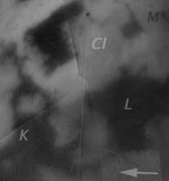
Below is NAC view (N00228357 from 256K km on 8-21-2014 CL1 CB3 filter) from the T104 flyby covering the Kraken (K) Ligeia (L) estuary. The cloudy region (Cl) between Muggel (M) and Ligeia is well shown, the estuary (arrow) just barely visible. The image shows the Looking Ahead ISS map (with a hint of radar) first and then the enhanced-cropped view of N00228357 fills in the right half of the scene.
|
|
|
|
|
|
|
Sep 16 2014, 01:19 AM
Post
#58
|
||
|
Member Group: Members Posts: 610 Joined: 23-February 07 From: Occasionally in Columbia, MD Member No.: 1764 |
QUOTE (titanicrivers @ Sep 5 2014, 10:58 AM) Below is NAC view (N00228357 from 256K km on 8-21-2014 CL1 CB3 filter) from the T104 flyby covering the Kraken (K) Ligeia (L) estuary.
The connection between Ligeia and Kraken may involve several parallel channels (hence I referred to it in my flushing paper as the Ligeia-Kraken Labyrinth, LKL) I'd say the Kraken inlet next one up from the labyrinth might be a better place for the label 'estuary'. (It was in this inlet that a radiometric change between T25 and T28 was observed, maybe suspended sediment?) |
|
|
|
|
|
|
Sep 30 2014, 05:08 PM
Post
#59
|
|
|
Senior Member Group: Members Posts: 3516 Joined: 4-November 05 From: North Wales Member No.: 542 |
The 'Magic Island' returns: http://photojournal.jpl.nasa.gov/catalog/PIA18430
|
|
|
|
|
Sep 30 2014, 09:41 PM
Post
#60
|
|
|
Member Group: Members Posts: 401 Joined: 5-January 07 From: Manchester England Member No.: 1563 |
I love mysteries, especially when their circumstances mandate that even the most mundane explanation will be extraordinary.....
-------------------- |
|
|
|
|

|
Lo-Fi Version | Time is now: 29th April 2024 - 12:57 PM |
|
RULES AND GUIDELINES Please read the Forum Rules and Guidelines before posting. IMAGE COPYRIGHT |
OPINIONS AND MODERATION Opinions expressed on UnmannedSpaceflight.com are those of the individual posters and do not necessarily reflect the opinions of UnmannedSpaceflight.com or The Planetary Society. The all-volunteer UnmannedSpaceflight.com moderation team is wholly independent of The Planetary Society. The Planetary Society has no influence over decisions made by the UnmannedSpaceflight.com moderators. |
SUPPORT THE FORUM Unmannedspaceflight.com is funded by the Planetary Society. Please consider supporting our work and many other projects by donating to the Society or becoming a member. |
|