Post Cook Islands Bedrock and Soil Science Studies, The 3rd leg in our Journey to Endeavour Crater |

  |
Post Cook Islands Bedrock and Soil Science Studies, The 3rd leg in our Journey to Endeavour Crater |
 Apr 17 2009, 10:36 AM Apr 17 2009, 10:36 AM
Post
#61
|
||
|
Newbie  Group: Members Posts: 3 Joined: 9-March 09 From: Russia, St-Petersburg Member No.: 4640 |
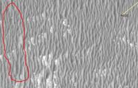
hi everyone! ) I have one little question for you. What is it? It's looks like a seam
 Maybe it is boundary between 2 photos... Maybe it is boundary between 2 photos...
Attached thumbnail(s)
|
|
 |
 
|
|
|
Apr 17 2009, 11:01 AM
Post
#62
|
||
 Special Cookie Group: Members Posts: 2168 Joined: 6-April 05 From: Sintra | Portugal Member No.: 228 |
Oops...here we go again...

You're right Tesheiner...  EDITED: Where is "94 days delay included" it should be read "119 days...", it makes all the difference...  For those thinking "why Porcupine?": http://www.deepseascape.org/history.php -------------------- "Ride, boldly ride," The shade replied, "If you seek for Eldorado!"
Edgar Alan Poe |
|
|
|
|
|
|
Apr 17 2009, 11:10 AM
Post
#63
|
||
|
Senior Member Group: Moderator Posts: 4279 Joined: 19-April 05 From: .br at .es Member No.: 253 |
> What is it? It's looks like a seam Maybe it is boundary between 2 photos...
Well, it's not an artifact created by GE because this discontinuity is also visible in the map projected JPEG2000 images. I have two guesses: 1. Something in the map projection software 2. It's a boundary between two CCDs in HiRISE. Here's a similar artifact near the same area but on a different picture.
|
|
|
|
|
|
|
Apr 17 2009, 12:45 PM
Post
#64
|
|
|
Solar System Cartographer Group: Members Posts: 10151 Joined: 5-April 05 From: Canada Member No.: 227 |
Yes, a seam between two CCDs. This is quite common in HiRISE images.
Phil -------------------- ... because the Solar System ain't gonna map itself.
Also to be found posting similar content on https://mastodon.social/@PhilStooke Maps for download (free PD: https://upload.wikimedia.org/wikipedia/comm...Cartography.pdf NOTE: everything created by me which I post on UMSF is considered to be in the public domain (NOT CC, public domain) |
|
|
|
|
Apr 17 2009, 02:37 PM
Post
#65
|
||
 Senior Member Group: Members Posts: 4246 Joined: 17-January 05 Member No.: 152 |
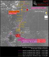
QUOTE (ustrax @ Apr 17 2009, 12:01 PM) 
According to this latest map from Ustrax, it's now clear why Oppy made that little "wrong-way" drive on sol 1820: she tried to keep to Ustrax's proposed path!
|
|
|
|
|
|
|
Apr 17 2009, 05:09 PM
Post
#66
|
|
 Junior Member Group: Members Posts: 82 Joined: 22-July 05 From: Portugal Member No.: 445 |
It also explains the elevated currents in the RF wheel.
She was trying to turn right, but they wouldn't let her
|
|
|
|
|
Apr 18 2009, 05:58 PM
Post
#67
|
|
|
Special Cookie Group: Members Posts: 2168 Joined: 6-April 05 From: Sintra | Portugal Member No.: 228 |
QUOTE (fredk @ Apr 17 2009, 03:37 PM) she tried to keep to Ustrax's proposed path! And you were doubtful?! -------------------- "Ride, boldly ride," The shade replied, "If you seek for Eldorado!"
Edgar Alan Poe |
|
|
|
|
Apr 19 2009, 12:59 PM
Post
#68
|
|
|
Member Group: Members Posts: 910 Joined: 4-September 06 From: Boston Member No.: 1102 |
Regarding the 1860 driver. There are no images for the end of the 1859 or 1860 drives at either the rover home or exploratorium sites. Was the 1860 drive planned based on the 1857 data? Can the rovers be driven blind for a second sol (without fresh navcam and/or pancam images) using the current software? I'm reading Scott's Mars and Me, at at the begining of the mission I think you couldn't. Possibly images our down, but just not available to us. Can Paolo, or anyone answer my questions.
-------------------- |
|
|
|
|
Apr 19 2009, 01:23 PM
Post
#69
|
|
|
Founder Group: Chairman Posts: 14432 Joined: 8-February 04 Member No.: 1 |
QUOTE (Floyd @ Apr 19 2009, 01:59 PM) There are no images..... On the raw image pages. There are, however, images on the ground, that the team can see. Probably just one of those 'give the server a kick' moments that happens from time to time in the raw JPG pipeline. |
|
|
|
|
Apr 20 2009, 08:18 PM
Post
#70
|
||
 The Poet Dude Group: Moderator Posts: 5551 Joined: 15-March 04 From: Kendal, Cumbria, UK Member No.: 60 |
Looking back.... over my shoulder...
-------------------- |
|
|
|
|
|
|
Apr 20 2009, 09:50 PM
Post
#71
|
|
 Member Group: Members Posts: 646 Joined: 23-December 05 From: Forest of Dean Member No.: 617 |
-------------------- --
Viva software libre! |
|
|
|
|
Apr 21 2009, 01:48 PM
Post
#72
|
|
|
Senior Member Group: Moderator Posts: 4279 Joined: 19-April 05 From: .br at .es Member No.: 253 |
Roving, roving, roving...
  90+ meters were added to the odometer this sol (1863) and we've covered almost half of Porcupine's diameter. Not really crossing but just bordering the crater (or its remains 'cause I can't really see it on the navcams). Check the route map in a few minutes... |
|
|
|
|
Apr 21 2009, 07:10 PM
Post
#73
|
|
|
Rover Driver Group: Members Posts: 1015 Joined: 4-March 04 Member No.: 47 |
I'm loving the pace it's setting
|
|
|
|
|
Apr 21 2009, 08:11 PM
Post
#74
|
|
|
Senior Member Group: Moderator Posts: 4279 Joined: 19-April 05 From: .br at .es Member No.: 253 |
And I think it will improve in a few hundred meters. We are approaching an area which looks it has smaller ripples so we may see longer drives, imo.
|
|
|
|
|
Apr 21 2009, 08:25 PM
Post
#75
|
|
|
Member Group: Members Posts: 713 Joined: 30-March 05 Member No.: 223 |
QUOTE (remcook @ Apr 21 2009, 09:10 PM) I'm loving the pace it's setting Ditto ! it's so good to see her making steady progress like this   |
|
|
|
|

|
Lo-Fi Version | Time is now: 25th April 2024 - 10:02 PM |
|
RULES AND GUIDELINES Please read the Forum Rules and Guidelines before posting. IMAGE COPYRIGHT |
OPINIONS AND MODERATION Opinions expressed on UnmannedSpaceflight.com are those of the individual posters and do not necessarily reflect the opinions of UnmannedSpaceflight.com or The Planetary Society. The all-volunteer UnmannedSpaceflight.com moderation team is wholly independent of The Planetary Society. The Planetary Society has no influence over decisions made by the UnmannedSpaceflight.com moderators. |
SUPPORT THE FORUM Unmannedspaceflight.com is funded by the Planetary Society. Please consider supporting our work and many other projects by donating to the Society or becoming a member. |
|