Printable Version of Topic
Click here to view this topic in its original format
Unmanned Spaceflight.com _ MSL _ MSL "Drive, drive, drive" toward Glenelg
Posted by: elakdawalla Sep 13 2012, 09:33 PM
https://twitter.com/Matt_Heverly/status/246296771427450881 earlier today that they're "on the road again," planning the seventh drive. So sol 39 will be a driving day, and it's time to start a new thread! In yesterday's press briefing, Joy Crisp said the plan was to "drive, drive, drive," though they will probably stop again before getting to Glenelg if they spot a good rock to use for the testing of drilling and sample acquisition and delivery.
As usual, keep conversation of the events and images of sols 30 through 37 in the http://www.unmannedspaceflight.com/index.php?showtopic=7454.
Posted by: ngunn Sep 13 2012, 10:03 PM
Can I just ask - why do we need such frequent thread changes? That last one was only 9 days. Not everybody keeps track of exactly when the image they want to comment on was acquired. I'm not surprised posts have been appearing in the wrong threads as fredk reports. For some who have interesting things to share this could be a barrier to contributing at all.
Posted by: Stu Sep 13 2012, 10:11 PM
It makes sense for two reasons.
1) MSL's operations so far have been split into very definite stages, so posting about events which occur during those periods in exclusive threads is a lot tidier than having one or two very long threads, with posts referring to events past, present and future. That's just very messy.
2) In the future, when MSL is working her way up Mt Sharp, and we want to look back on the rocks she saw, and the vistas she stared out and up at before she headed for The Promised Land, for comparison, it will be much easier to locate that information.
Posted by: ngunn Sep 13 2012, 10:34 PM
I agree that makes sense over the longer term. When we're up the hill we'll need to refer back to when we were down on the plain, and that should be in a separate place. But by then, who will remember the many different phases of the engineering checkout? I think one pre-Glenelg thread would have been enough, and more in keeping with the pace adopted for Opportunity, which has proved highly successful.
Anyhow, that's my last post on the subject. I love this place and don't want to rock the boat.
Posted by: brellis Sep 13 2012, 10:52 PM
We mustn't ~needle~ the Admins about their threads.  *backs away, carefully*
Posted by: elakdawalla Sep 13 2012, 10:58 PM
I know I'm not alone among journalists (or scientists) who try to use UMSF as a historical archive of mission events, and for really nice-quality processed versions of raw images. In the beginning of the MER missions we weren't so careful, and those threads are incredibly difficult to hunt through for images. Over time the MER threads developed their method of beginning new threads with drives, which has really helped in sorting the history.
Keeping track of which sol the image was captured on is not only easy (it's listed in the filename of the Malin cameras, and is easy to firgure out using Ludo's or Joe's raw image browsers) but it's also important, because there is a context and a reason for taking photos that you can really only keep track of by following the mission chronology.
The first part of the mission will get chopped up into smaller pieces because there is so much interest and so many people trying new things with the images, and also because Curiosity's drives are short. Once we've gotten used to the mission and to the types of images it returns and we understand what we're seeing in the images and have begun to rely on certain people for producing certain kinds of image products, the post rate will drop and the amount of time covered in one thread will lengthen. Still, we'll generally try to keep it down to a few hundred posts per thread.
This thread may last longer than previous ones, because hopefully we're really looking at the beginning of the science mission here. I'm guessing it'll last until we arrive at Glenelg, and we'll break it and start a new thread there. Curiosity's mission, like Opportunity's, will probably separate fairly neatly into interleaved drives and science sites; these threads will reflect that.
Posted by: fredk Sep 13 2012, 11:06 PM
I think the "sols x through y" subtitles are going to be really useful down the road. Another idea would be to demark the various mission phases on a route map, to help people find the corresponding thread.
Posted by: MahFL Sep 14 2012, 01:01 AM
When Curiosity is driving in-between 100 m high mesa's and butts I think the plains will be quite forgotten  .
.
Posted by: Tom Tamlyn Sep 14 2012, 02:02 AM
von Kármán lecture on Curiosity's first month starting now.
http://www.ustream.tv/nasajpl2
Posted by: Tom Tamlyn Sep 14 2012, 04:20 AM
Not much that would have been new to umsf members.
Richard Cook estimated that ChemCam has made several hundred observations already (my question, submitted via chat).
Edit: Cook also said that when the drivers are able to employ the full range of Curiosity's navigation software capabilities (I think he mentioned visual odometery as one, although I didn't think that the VisDom mode is known for speed), Curiosity would be able to drive about 100-200 meters on a good day. The suggestion that 200 meter days might become routine on appropriate terrain (he didn't use those words, but that's my sense of what he was saying) is more aggressive than comments that I recall from past press conferences. But of course, we'll get there when we get there ...
Posted by: akuo Sep 14 2012, 05:35 AM
200 metres per sol is the original engineering goal for MSL, that has been mentioned in various sources. Of course it depends on the navigation needed because of the terrain, but I'd expect it would be achievable in this terrain before the dunes and the mountain. I have been a bit surprised by the last few short drives - I thought there would be more of an increase after the first couple of drivers. Though I guess the last drive was targeted, since they needed a specific spot for the arm calibrations.
Posted by: mhoward Sep 14 2012, 08:13 AM
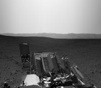
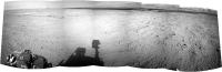
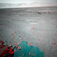
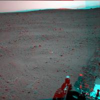
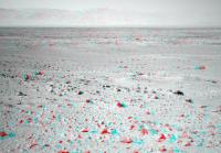
Sol 38 drive images are down. Here's a quick Navcam anaglyph looking forward and right a bit.

|
Posted by: Tesheiner Sep 14 2012, 09:03 AM
And here's a 5x1 navcam mosaic.

|
BTW, on MER the navcam shots were spaced 36 degrees so a whole 360deg. mosaic was composed by 10 pictures. But MSL seems to be always taking 12 images, spaced by 30 degrees although the cameras have the same FOV, IIRC.
Posted by: pmetschan Sep 14 2012, 05:33 PM
sorry if this has been asked but is Glenelg visible in this image and if so where? Could someone "red arrow" it?
Posted by: djellison Sep 14 2012, 06:03 PM

I've never seen figures that high quoted anywhere. Where do you get that number from?
Posted by: centsworth_II Sep 14 2012, 06:37 PM
I'm guessing the 200m per sol figure is hoped-for long drive capability based on experience with the MERs. From the below, it looks like the mission requirement was for 50m per sol.
"The following table summarizes some of the key resources affecting operations and the required capability for each."

http://msl-scicorner.jpl.nasa.gov/scienceplanning/
Posted by: akuo Sep 14 2012, 06:51 PM
For example in the MSL Fact Sheet: http://mars.jpl.nasa.gov/msl/news/pdfs/MSL_Fact_Sheet.pdf
"...travel up to about 200 meters (660 feet) per day on Martian terrain."
Posted by: Hungry4info Sep 14 2012, 06:55 PM
I think the difference is "designed to" vs "mission requirement."
Posted by: akuo Sep 14 2012, 07:10 PM
Yeah, I didn't mean "goal" in the sense of a mission requirement. As far as I understand, the mission requirement is to survive a Martian year and to fulfil the science goal. The roving ability is there to support that.
It would be interesting to know how much of an estimated advantage in roving distance Curiosity has over MER because of the larger size - that is bigger clearance over obstacles and an ability to see further ahead for blind drivers, because of the higher elevation of the navigation cameras.
Posted by: Oersted Sep 14 2012, 07:13 PM
Maybe it would be good to have the starting date as the beginning of the thread title, like this: 2012-09-14. MSL drive etc etc. It is really hard to beat chronology as an organizing tool, I speak as a historian!
Posted by: centsworth_II Sep 14 2012, 07:19 PM
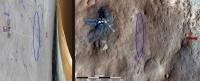
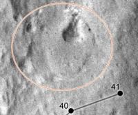
Combining jmknapp's "FWIW, the Google Mars view (based on a MOLA DEM I think) shows that Glenelg is below a rise in the foreground" image http://www.unmannedspaceflight.com/index.php?s=&showtopic=7413&view=findpost&p=189188 (on left, rotated) with an MSL route map from http://www.spaceflight101.com/msl-mission-updates-4.html (on right). It looks like we may see it after another drive or two?
(My eyeball estimate of the rise location between landing site and Glenelg circled in blue.)
|
Posted by: centsworth_II Sep 14 2012, 07:23 PM
Posted by: atomoid Sep 14 2012, 07:36 PM
|
|
http://msl-scicorner.jpl.nasa.gov/scienceplanning/
What surprises me is the "Rover awake Time" of 6 hours.. only six hours? with RTG power, why 'sleep' at all? (ok maybe i should read more specs)
based on RTG power alone, MSL should be able to quarduple the distance per SOL over MER (Oppy's top was i think over 200 M on one SOL, If MSL did that for 24 hours, we could theoretically do a mile in 2 days instead of 8 in the optimal scenario..
Posted by: fredk Sep 14 2012, 07:39 PM
I thought the main advantage for MSL over MER in terms of drive distance per sol was the height of the mast cameras (as akuo mentioned) and also the resolution of MC100. Both mean potential obstacles can be spotted farther away, and so longer non-blind drives can be planned. (Also there's power, which can negatively affect MER drives in times of very low solar array output).
Of course we'll just have to see what they can do with MSL.
Posted by: Phil Stooke Sep 14 2012, 08:12 PM
"based on RTG power alone, MSL should be able to quarduple the distance per SOL over MER "
It's a mistake to think of MSL as RTG powered. Like MER it is really battery powered. The RTG just trickles power into the batteries. (as I understand it, and really I'm just repeating others here - I think Doug said pretty much exactly this).
I'm nearly home and will soon be working on route maps again. East of Boston right now.
Phil
EDIT - east of Boston (changed it above) - not west! I have been the Enrichment Lecturer on a cruise ship. It's a tough life, but somebody has to do it.
Posted by: helvick Sep 14 2012, 08:16 PM
RTG power is not limitless, it's still only around 100-125watts max. MSL uses it in just the same way the MER's used their solar panels, to charge it's batteries which can then provide the power to cover the many things that MSL can and must do when she's active that add up to a lot more than 100watts of load. So she has to get her beauty sleep to recharge her batteries.
Posted by: climber Sep 14 2012, 08:29 PM
Phil
Ready for EDL I suppose!
Welcome on Mars
Posted by: MahFL Sep 14 2012, 08:38 PM
The main advantage is MSL won't have to stand down during the winter. As for returned data they did more than 500 megabits with MRO in one pass. Once out of Mars time though the team won't always be able to prepare the next days upload in time, so there will be quiet days, where I guess some safe run out science could be done. Also Mr Cook said they expect to have 10 years or more to explore. Of course they will have a "time line" to try accomplish the main mission objectives, which I suspect maybe extended beyond two years should MSL continue to be a reliable spacecraft.
What happened to Pete ?, as I see on the MSL website Cook is now the MSL Project Manager.
Edit : Wiki says this...
"He is currently director for the Engineering and Science Directorate at the Jet Propulsion Laboratory."
I guess Pete Theisinger got promoted .
Posted by: djellison Sep 14 2012, 09:35 PM
Exactly that. It consumes more than 110Watts to 'run' the rover - and some activities use much much more than that. You use up battery power during the day, and then recharge with the RTG over night.
That information is probably out of date. Richard was MSL ProjMang for a while a few years back as Pete had some medical issues to deal with. Then Pete took the position again. At the moment, it's still Pete at the top and Richard as his deputy.
Posted by: DFinfrock Sep 14 2012, 10:07 PM
Or perhaps when each thread is closed, an admin can change the title, with a prefix, such as "Sol 34 - Sol 58, Drive, Drive, Drive toward Glenelg".
Posted by: DFinfrock Sep 14 2012, 10:12 PM
Another advantage... no real worry about tau. Although dust storms will still be a concern for some of the instruments; keeping lens covers in place for instance.
Posted by: RoverDriver Sep 14 2012, 11:00 PM
Of course we'll just have to see what they can do with MSL.
NAVCAMs have a higher vantage point and wider baseline and they yield good range data to 30-40 meters. MASTCAMs are yet to be used for driving. They have a narrow field of view so we would need more frames to cover an area similar to PANCAMs. Moreover, the foreshortening would still limit our visibility of potential obstacles. I doubt we will be able to extend MSL blind driving much beyond what MER did. The real advantage on MSL is the more powerful processor that should speed up VO and AutoNav driving.
Paolo
Posted by: RoverDriver Sep 14 2012, 11:03 PM
Both Winter and Tau will affect the heating requirements therefore reducing amount of science and drive/arm time.
Paolo
Posted by: MahFL Sep 14 2012, 11:43 PM
Paolo
Early on they did say MSL was little warmer than expected, which would mean slightly less power needed for heaters in the winter. The external actuators though would still need the normal amount of heating.
Posted by: EdTruthan Sep 15 2012, 12:22 AM
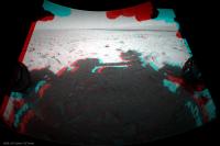
"On the Road Again" anaglyphs from Sol 38:

|
Posted by: Tesheiner Sep 15 2012, 07:04 AM
That's nice but redundant because it is already included on each topic's description. Check the second (and smaller) line below each thread's title http://www.unmannedspaceflight.com/index.php?showforum=59.
Posted by: climber Sep 15 2012, 12:25 PM
I think it was because temperatures at Gale were slightly higher than expected..?
Posted by: mhoward Sep 15 2012, 01:22 PM
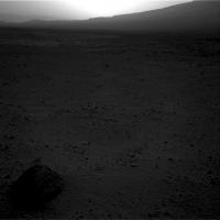
Another drive on sol 39. Looks like we are approaching a little scenic overlook, maybe?
|
Posted by: RoverDriver Sep 15 2012, 04:04 PM
Yes, Gale is a little warmer than we thought and we also have a bit more power than anticipated but that does not mean that for *driving* the Winter heating requirements are going to be more taxing. Currently we are not power limited but once the RTG starts to slow down, there will be differences between seasons. We'll see how much impact it will be.
Paolo
Posted by: climber Sep 16 2012, 12:13 AM
I'm guessing the 200m per sol figure is hoped-for long drive capability based on experience with the MERs. From the below, it looks like the mission requirement was for 50m per sol.
"The following table summarizes some of the key resources affecting operations and the required capability for each."
|
|
http://msl-scicorner.jpl.nasa.gov/scienceplanning/
You know what? In this week issue of Aviation Week they wrote 40km (25 miles) a day!
Ok that's a tipo...I wouldn't risk to put this remark in the "Bad reporting" topic! Well may be in "MSL Humor" one

Posted by: Jam Butty Sep 16 2012, 12:20 AM
A couple of Navcam flicker gifs from Sol 38...
|

|
Posted by: Stu Sep 16 2012, 08:36 AM
Colour 2 frame mosaic close-up of part of the first of JB's gifs...

|
Such gorgeous detail and colour. Just wish I knew more geology...
Posted by: paraisosdelsistemasolar Sep 16 2012, 09:23 AM
Wow, this layer looks amazing! I can't tell the origin of it, but it lacks (as far as I can see) internal sorting. It could be a lot of things: tuff, debris flow depopsit, a breccia... we need to have a closer (and compositional) look at it 
|
|
Such gorgeous detail and colour. Just wish I knew more geology...
Posted by: fredk Sep 16 2012, 02:37 PM
After the sol40 drive, I think we've now got a pretty clear view onto Glenelg - here's a navcam anaglyph:

|
Posted by: mhoward Sep 16 2012, 02:38 PM
Sol 40.
|
Posted by: Ant103 Sep 16 2012, 02:38 PM
Sol 39 Navcam pan.
http://www.db-prods.net/marsroversimages/Curiosity/2012/Sol39_pano.jpg
Posted by: akuo Sep 16 2012, 03:08 PM
Is anybody attempting to map Curie's positions on sol 39&40? Doing this by eye seems to be more difficult than with MER, since the strategy seems to be to image 360 degrees of navcam thumbnails and full resolution only in the drive direction.
Great to see three sols of back-to-back driving though
Posted by: djellison Sep 16 2012, 03:12 PM
Obviously the team at JPL are doing just that, and the amateur efforts will appear here when people have had the time to figure it out
http://www.unmannedspaceflight.com/index.php?showtopic=7442&st=20&start=20
Posted by: Ant103 Sep 16 2012, 03:40 PM
And Sol 40 panoramics. The last with some extra-sky 
http://www.db-prods.net/marsroversimages/Curiosity/2012/Sol40_pano.jpg
|
Posted by: Phil Stooke Sep 16 2012, 04:03 PM
"Is anybody attempting to map Curie's positions"
Phil reporting from Logan Airport in Boston... finally on my way home. I was just downloading all the nice pans from Ant and others, and by tomorrow I will be busy reprojecting them and estimating locations. Look for a route map update very soon. Right now I am especially interested in any placenames - rock names, Chemcam target names etc. that may have popped up in twitter feeds etc. while my access has been very limited. If anyone has seen anything and can alert me to them \i would appreciate it.
Phil
Posted by: Tesheiner Sep 16 2012, 04:32 PM
Not really. If you see a thumbnail almost sure the full-res is there too. It's just a question of downlink queue priorities. The drive-direction images take a higher one while the backwards-looking ones have low prio.
Posted by: mhoward Sep 16 2012, 04:49 PM
I'd add that this is exactly how it's always worked with MER, except with MER we never got to see the thumbnails on the main raw images page. So this is a nice enhancement, a kind of 'preview' just like the rover team gets.
Posted by: EdTruthan Sep 16 2012, 08:57 PM
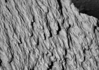
Just down within the hour... Six additional full res MC100 frames to fill out the surrounding areas of the interesting Sol 39 Rock formation. Oh my, there's some truly glorious detail in there...
http://www.edtruthan.com/mars/Sol39-MC100-Rock-Formation-Mosaic-Full.jpg
Posted by: vikingmars Sep 16 2012, 10:13 PM
How nice ! Thanks a lot Ant 103 for sharing it with us...
Posted by: Ant103 Sep 16 2012, 11:43 PM
And here's my take
http://www.db-prods.net/marsroversimages/Curiosity/2012/Sol39_Mastcam100.jpg
Yes, some good details there, a beautiful rock indeed .
Thank you Olivier
Posted by: jmknapp Sep 17 2012, 12:57 AM
It'd be good to see some ML shots to get 3D views of that.
The bedrock or whatever it is kind of looks like asphalt. It seems to be very erodable by the wind/sand, so the pebbles are eroding out of it?
Posted by: Juramike Sep 17 2012, 01:27 AM
Very rounded pebbles and cobbles, I might add....
Posted by: Phil Stooke Sep 17 2012, 01:42 AM
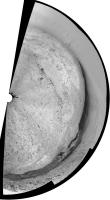
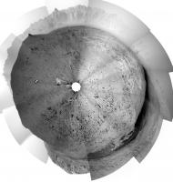
This is Ant103's sol 40 pan in a circular format. I hope we will get the rest of it, but a few points can be matched to HiRISE. The black rock at upper centre is the very prominent block about 200m east of the landing site. Glenelg shows up well, and a prominent crater south of the lighter terrain unit can be seen easily. I have added a key to some of these. (I have not necessarily made the angle of the half-panorama correct, I'll check it later)
Phil
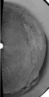
|
|
Posted by: Bill Harris Sep 17 2012, 01:49 AM
Yes indeed, sir. Nice clastics.
--Bill
Posted by: Stu Sep 17 2012, 02:52 PM
Rather gorgeous view of the foothills of Mt Sharp now...

|
...and some fascinating geology in view now, too...

|
Posted by: mhoward Sep 17 2012, 03:11 PM
Sol 41, another step closer.
http://www.flickr.com/photos/marscat/7996240620/
http://www.flickr.com/photos/marscat/7996240620/, on Flickr
http://www.flickr.com/photos/marscat/7996231171/
http://www.flickr.com/photos/marscat/7996231171/, on Flickr
Posted by: climber Sep 17 2012, 05:15 PM
|
|
According to Phil, 3 posts higher, that's Glenelg that's showing.
Posted by: fredk Sep 17 2012, 05:27 PM
Stu's two mosaics (and Ed's in the other thread) actually fit together, so Stu's colour one is not Glenelg, but towards the west.
Posted by: Phil Stooke Sep 17 2012, 06:20 PM
This is the sol 39 half panorama reprojected.
Phil
|
Posted by: mhoward Sep 17 2012, 06:39 PM
Specifically http://flic.kr/p/dbCiU5
Posted by: Pete B. Sep 17 2012, 07:37 PM
It looks like a small outcrop of the high TI unit 100+ m south of Bradbury Landing. It shows up well in this MRO image from Emily's blog.
https://planetary.s3.amazonaws.com/assets/images/charts-diagrams/20120906_curiosity_route_map_sol0029_PIA16148.jpg
Posted by: Phil Stooke Sep 17 2012, 08:33 PM
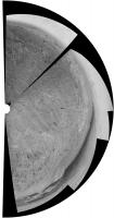
A couple more reprojected panoramas to help with locations. The full circle is from sol 29 but as the rover was still here on the morning of sol 38 I can slip it in here (to keep them all together).
Phil
Sols 29-37:
|
Sol 38:
|
Posted by: CosmicRocker Sep 18 2012, 04:59 AM
That's quite nice.
I can't wait.
Posted by: Tesheiner Sep 18 2012, 11:29 AM
A navcam mosaic.

|
Posted by: akuo Sep 18 2012, 12:22 PM
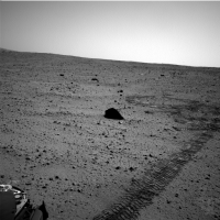
Sol 42 drive images are up. The shadows are long and the dynamic range in the navcam images appears quite high. We've been roving late into the afternoon?
Posted by: jmknapp Sep 18 2012, 12:30 PM
About 3:30pm LMST, about 2 hours before sunset. The sun is practically just directly behind the camera in the http://mars.jpl.nasa.gov/msl-raw-images/proj/msl/redops/ods/surface/sol/00042/opgs/edr/ncam/NRA_401232925EDR_F0041632NCAM00427M_.JPG ones, which might explain the brightness toward the center (backscatter).
Posted by: xflare Sep 18 2012, 12:40 PM
They look very "MER" like now....and different JPEG compression? Look at the horizon/sky
http://mars.jpl.nasa.gov/msl-raw-images/proj/msl/redops/ods/surface/sol/00042/opgs/edr/ncam/NLA_401232890EDR_F0041632NCAM00427M_.JPG
http://mars.jpl.nasa.gov/msl-raw-images/proj/msl/redops/ods/surface/sol/00042/opgs/edr/ncam/NLA_401233023EDR_F0041632NCAM00427M_.JPG
Compare to this from Spirit on SOL 74 NAVCAM:
http://marsrovers.jpl.nasa.gov/gallery/all/2/n/074/2N132942488EFF2100P1827R0M1.JPG
Posted by: climber Sep 18 2012, 01:41 PM
Sorry Stu & All, my bad.
Posted by: Phil Stooke Sep 18 2012, 02:09 PM
Sol 41 half-panorama reprojected. This enables a very good match to topography, confirming the previous estimate (or very near it) despite me saying it might have to change in the route map thread. But sol 40 had to be changed, as the new map shows.
Phil
|
Posted by: dvandorn Sep 18 2012, 02:49 PM
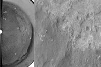
I'm assuming that the marked areas in the next two images, from above and from the surface, are the same feature?
|

|
From above, this feature looks, at first glance, to have a crater morphology (until you look closely and see that its edges are in positive, rather than negative, relief). From the ground, it kind of resembles a miniature version of Home Plate.
As Stu said -- fascinating geology. Almost looks like a sedimentary process laid down a fill inside a small crater which has been more resistant to erosion than the surface in which the crater was originally formed.
-the other Doug
Posted by: mhoward Sep 18 2012, 03:06 PM
From Sol 42:
http://www.flickr.com/photos/marscat/7999849996/
http://www.flickr.com/photos/marscat/7999843147/
Posted by: fredk Sep 18 2012, 03:19 PM
Posted by: dvandorn Sep 18 2012, 03:29 PM
Okay. In that case, I'm finding it really difficult finding the feature in the surface image in the overhead context. And, correct me if I'm wrong, but while the feature I marked in the overhead was more north of us at the Sol 40 position, is it not west-northwest of us now?
I suppose the mastcam mosaic in question was taken well before either of those two stops, though. Ah, well. The surface feature still looks interestingly like some kind of cemented underfloor.
-the other Doug
Posted by: Phil Stooke Sep 18 2012, 04:02 PM
Doug - see my route map... the outcrop is due south of the sol 24 position near the SW corner of my map. I suppose it might be looked at on the way back from Glenelg towards the main science area to the west.
Phil
Posted by: centsworth_II Sep 18 2012, 04:04 PM
Posted by: Doc Sep 18 2012, 04:24 PM
I actually thought there had been a change in the camera's default brightness/contrast settings!
Posted by: dvandorn Sep 18 2012, 04:24 PM
Thanks! It can be a little difficult recognizing these flat-to-the-ground features from above, can't it?
-the other Doug
Posted by: akuo Sep 18 2012, 04:39 PM
While the lighting conditions do have an effect, the thinking is that there has been change to the contrast stretch and jpeg quality in the released "raw" images. See the discussion here: http://www.unmannedspaceflight.com/index.php?showtopic=7418&pid=191664&st=105&#entry191664
Posted by: charborob Sep 18 2012, 05:31 PM
Here is a wider panorama of sol 42 navcams:
|
There is something I don't understand on the MSL raw images page:http://mars.jpl.nasa.gov/msl/multimedia/raw/. The number of images in the list does not reflect the actual number of images visible. For example, for the front hazcam the list says "Sol 042 (4 img)". When I click on the link, I see only one "Full data product" and one "Thumbnail data product". This happens in many places. I'm just curious to know the reason for the discrepancy.
Posted by: Ant103 Sep 18 2012, 05:32 PM
So, even if this tosol pics are to stretched from my point of view, here is the Sol 42 navcam panoramic.
http://www.db-prods.net/marsroversimages/Curiosity/2012/Sol42_pano.jpg
I had to be a little bit more stronger with processing, in order to retrieve a much better imagery.
Posted by: Phil Stooke Sep 18 2012, 06:16 PM
... and the previous nice pan by Ant103 reprojected.
Phil
|
Posted by: Doc Sep 18 2012, 06:32 PM
Seeing the navigation images are coming down in sets of 5 showing the same view for the past few sols, I tried stitching them all up and put together a (rough) animation to see our progress from the ground.

|
It is rather small so apologies for that. The full version will be on my blog in time.
Posted by: belleraphon1 Sep 18 2012, 07:38 PM
http://www.nasa.gov/news/media/newsaudio/index.html
NASA Hosts Teleconference About Mars Curiosity Rover Progress
Wednesday, Sept. 19 at 2 p.m. EDT
NASA will host a media teleconference to provide a status update on the Curiosity rover's mission to Mars' Gale Crater.
Curiosity, the Mars Science Laboratory, is 43 days into a two-year mission to investigate whether conditions may have been favorable for microbial life.
For teleconference dial-in information, reporters must send their name, media affiliation and telephone number to Elena Mejia at elena.mejia@jpl.nasa.gov or call NASA's Jet Propulsion Laboratory Media Relations Office at 818-354-5011.
Note: A UStream player with audio of the briefing will appear here shortly before the event.
Visuals supporting the briefing are/will be available at http://go.nasa.gov/curiositytelecon.
Posted by: Zeke4ther Sep 19 2012, 05:42 AM
JPL has been posting updates on the MSL project page.
http://mars.jpl.nasa.gov/msl/news/whatsnew/index.cfm?FuseAction=ShowNews&NewsID=1349
What is interesting is that on September 17th, the use of DAN was part of the regular drive sequence.
Posted by: RoverDriver Sep 19 2012, 02:09 PM
We have been doinc DAN observations while driving for the past three drives already. Two observations on each drive.
Paolo
Posted by: EdTruthan Sep 19 2012, 04:03 PM
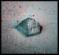
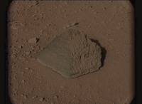
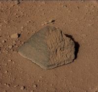
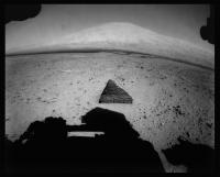
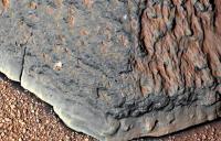
Sol 43... Not sure what the science team has christened this one with yet, but "Little Egypt" seems about right to me....
|
...and a closer look:
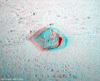
|
Posted by: mhoward Sep 19 2012, 04:48 PM
As we can see from the hazcam view, the rock (whatever it will be called) is basically dead ahead.
http://www.flickr.com/photos/marscat/8003512409/ http://www.flickr.com/photos/marscat/8003509741/
And to the left:
http://www.flickr.com/photos/marscat/8003521218/ http://www.flickr.com/photos/marscat/8003520388/
Posted by: charborob Sep 19 2012, 05:10 PM
Sol 43 navcam panorama:
|
|
(I'm having some trouble getting Photoshop to produce a straight horizon.)
Posted by: jmknapp Sep 19 2012, 05:35 PM
So is that the rock chosen to be the first APXS, etc. subject? They've been saying they're looking for a "fine-grained" specimen for whatever reason and one that can stand to be pushed against with some force. Why do they need x amount of force?
Posted by: Phil Stooke Sep 19 2012, 05:38 PM
For brushing and/or drilling.
I'm not sure this is big enough. (EDIT - guess it is!)
Phil
Posted by: Paolo Sep 19 2012, 06:03 PM
rock is apparently called 'Jake Matijevic' and will be the first target for contact science
http://www.nasa.gov/mission_pages/msl/multimedia/pia16155.html
Posted by: john_s Sep 19 2012, 06:18 PM
I was surprised to see how big that rock is- about a foot across. After years of mentally correcting for the fact that objects in MER images are smaller than they appear, I need to recalibrate.
John
Posted by: climber Sep 19 2012, 06:26 PM
Do you have any audio right now? I don't
Posted by: Paolo Sep 19 2012, 06:26 PM
yep! here in Haute Garonne audio is fine
Posted by: climber Sep 19 2012, 06:29 PM
I'm in Chile!
Visuals but no audio and UStream says the event will start in 4h25 mn....ahahah. Well, I'll watch replay
Posted by: DEChengst Sep 19 2012, 06:36 PM
Ustream didn't auto play for me. Try pressing the play button. I missed the first few minutes because of that.
Posted by: Stu Sep 19 2012, 06:37 PM
Is that Glenelg appearing just over that ridge, there..?
|
Posted by: Paolo Sep 19 2012, 06:42 PM
did they speculate on the dark bands visible in front of Glenelg in http://www.nasa.gov/mission_pages/msl/multimedia/pia16150.html ?
I may have lost it
Posted by: fredk Sep 19 2012, 06:44 PM
No, it's farther to the right, in mhoward's mosaics. Check the press release images too.
Posted by: jasedm Sep 19 2012, 06:46 PM
Quoting mhoward upthread...
"As we can see from the hazcam view, the rock (whatever it will be called) is basically dead ahead."
This looks meteoritic to me - they're often pyramidal following their burn through the atmosphere - some comparisons:
|
|
Posted by: Phil Stooke Sep 19 2012, 06:50 PM
You can see Jake sitting right beside the sol 43 position in my route map.
Phil
Posted by: elakdawalla Sep 19 2012, 06:51 PM
Thanks, Phil -- I was going to ask that question Now I can ask something else!
Posted by: Stu Sep 19 2012, 06:57 PM
Great, thanks. Just remembered there's a press conference *on*...
Posted by: Ant103 Sep 19 2012, 07:29 PM
Sol 43 Navcam pan
http://www.db-prods.net/marsroversimages/Curiosity/2012/Sol43_pano.jpg
I like this little rock !
Posted by: dvandorn Sep 19 2012, 07:34 PM
There are a tremendous number of pyramid-shaped rocks on Mars. They are classed under the general name ventifacts. The pyramidal sides are caused by eons of wind erosion. This creates a number of shapes, including the pyramidal.
Look through the images from the MERs -- you'll see quite a few examples. Heck, there are several ventifacts in view at both Viking landing sites and at the Pathfinder site.
-the other Doug
Posted by: dvandorn Sep 19 2012, 07:45 PM
Hmmmmm... is it just my imagination, or does ol' Jake here have spherules embedded in it? See the circled features below.

|
-the other Doug
Posted by: Tesheiner Sep 19 2012, 08:00 PM
http://www.nasa.gov/mission_pages/msl/multimedia/pia16155.html
You can read more about Jake Matijevic on Salley Rayl's http://www.planetary.org/explore/space-topics/space-missions/mer-updates/2012/08-mer-update-opportunity-greets-curiosity.html. Just scroll down to the section "In Memoriam: Jake Matijevic".
Posted by: Phil Stooke Sep 19 2012, 08:01 PM
Ant103's fourmidable panorama in circular format. After a little bump it looks like we will be here for a few sols.
Phil
|
(PS - doug - spherules? They could be any kind of lump and/or bump at this resolution)
Posted by: Stu Sep 19 2012, 08:01 PM
3D view of "Jake M"
|
Posted by: dvandorn Sep 19 2012, 08:08 PM
Oh, agreed. I was only put in mind of spherical inclusions because of two of the features I circled in particular -- in the row of three of my marking circles along the right side of the rock, the second down shows what looks like an empty socket, and the feature below it reflects light into a nice little subsolar point that suggests a spherical surface to me.
Obviously, we will have closer images in the next few Sols. I'm really looking forward to seeing what MAHLI can do on a close inspection, here.
-the other Doug
Posted by: kenny Sep 19 2012, 08:28 PM
I remember Jake well; he did a few of the early MER video flight director's reports to camera covering the past "week on Mars". As he moved from Spirit to Opportunity he would say something like: "Meanwhile, over on the other side of the planet..."
Posted by: mhoward Sep 19 2012, 09:44 PM
Here's a wider-angle view of Curiosity's tracks and Jake Matijevic rock.
http://www.flickr.com/photos/marscat/8004278797/
http://www.flickr.com/photos/marscat/8004279080/
Posted by: jasedm Sep 19 2012, 09:44 PM
-the other Doug
Thanks Doug, have just educated myself on the aforementioned ventifacts. Apparently in Afrikaans there's a word for just this type of feature - "dreikanters" meaning "three corners" - a rock abraded by wind action over large timescales which often results in pyramidal shapes. It just looks so alien sitting there....
Posted by: ngunn Sep 19 2012, 09:58 PM
What intrigues me about this rock is that there appears to be something brightening it where it's in contact with the ground. Salts? Any ideas?
Posted by: jasedm Sep 19 2012, 10:19 PM
Yes, on closer inspection, there does appear to be efflorescence on the lower edge, something else which militates against meteoritic origin.
Posted by: brellis Sep 19 2012, 11:21 PM
Is Curiosity capable of breaking apart some of these small rocks simply by rolling over them?
Posted by: Phil Stooke Sep 19 2012, 11:56 PM
Weak sedimentary rocks, probably, chunks of basalt and iron meteorites, no!
Phil
Posted by: mhoward Sep 20 2012, 12:23 AM
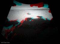
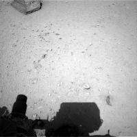
So, this is kind of interesting, maybe: looks like some kind of reflection on sol 38. Reflection off of what? Appears in both eyes.
http://mars.jpl.nasa.gov/msl/multimedia/raw/?rawid=NLA_400871699EDR_F0040404NCAM00421M_&s=38
|
Posted by: Jam Butty Sep 20 2012, 01:08 AM
Sol 43 navcam...
flicker video starring Jake Matijevic
http://youtu.be/6Adqw1moLtM
Posted by: centsworth_II Sep 20 2012, 01:26 AM
Here's one: http://www.youtube.com/watch?v=I_MzQkWR3JU

|
Posted by: CosmicRocker Sep 20 2012, 05:49 AM
Thanks. It's good to see the face that belongs on that memorial.
Posted by: jmknapp Sep 20 2012, 03:06 PM
A whole boatload of images came in today that were taken at sunrise, sol 42. Didn't know Curiosity was a morning person!
e.g.,
http://mars.jpl.nasa.gov/msl-raw-images/msss/00042/mcam/0042MR0181002000C0_DXXX.jpg
...and this NAVCAM taken 3 minutes after sunrise on sol 44:
http://mars.jpl.nasa.gov/msl/multimedia/raw/?rawid=NLA_401372839EDR_T0042002NCAM00517M_&s=44
Posted by: fredk Sep 20 2012, 03:15 PM
Those would be the morning transit images.
Posted by: Tesheiner Sep 20 2012, 03:36 PM
Today's batch include a set of five navcams showing the http://mars.jpl.nasa.gov/msl/multimedia/raw/?rawid=NLA_401400251EDR_F0042002NCAM00202M_&s=44. It's shadow, actually.
I still find it somehow difficult to change from the MER experience to MSL. For instance, yesterday's images of Jake M. gave me the impression it was still too far of the arm workvolume and today we would see another bump to approach it. Of course (!) this arm is much longer than MER's and I just forgot that.
Posted by: ddan Sep 20 2012, 03:38 PM
-the other Doug
The interesting part for me is that it has some horizontal striations on the left side and vertical ones on the right side. Image processing artifacts?
Posted by: Ant103 Sep 20 2012, 04:17 PM
This image is too dark. Why don't they stretch it. Just like this !

|
Posted by: Joffan Sep 20 2012, 04:26 PM
Just out of reach.... but presumably close enough for MAHLI and perhaps (but probably not) APXS work. It's interesting to see the arm apparently at full stretch.
http://mars.jpl.nasa.gov/msl-raw-images/proj/msl/redops/ods/surface/sol/00044/opgs/edr/ncam/NLA_401400251EDR_F0042002NCAM00202M_.JPG
Oh yes... and did we actually get some ChemCam zaps on Jake?
Posted by: charborob Sep 20 2012, 05:05 PM
Anaglyph of the ground with the arm shadow:

|
Posted by: RoverDriver Sep 20 2012, 05:18 PM
I still find it somehow difficult to change from the MER experience to MSL. For instance, yesterday's images of Jake M. gave me the impression it was still too far of the arm workvolume and today we would see another bump to approach it. Of course (!) this arm is much longer than MER's and I just forgot that.
These images have been captured to verify the change in vehicle attitude when the arm is fully stretched and in other configurations. We approached Jake Matijevich from 30m away and intentionally kept at a safe distance. The bump to have the rock within the work volume will be done on Sol 45.
Paolo
Posted by: udolein Sep 20 2012, 05:36 PM
weird scene: Curiosity threatens Jake Matijevic
|
http://www.marspages.eu/media/archive4/science_laboratory/9glenelgdrivecontinuation/Sol44_Movie.gif
Cheers, Udo
Posted by: centsworth_II Sep 20 2012, 07:35 PM
Run that sped up with the http://www.youtube.com/watch?v=KF_6gI0xHzw playing and you've got something!
Posted by: Ant103 Sep 20 2012, 07:57 PM
Glenelg in color @100mm.
http://www.db-prods.net/marsroversimages/Curiosity/2012/Sol42_Mastcam100.jpg
Posted by: fredk Sep 20 2012, 08:32 PM
I had an idea that I don't have time to do myself, so I'll just contribute the idea. I often think it would be nice to have an easy to read visual reference for mastcam imagery of Sharp. There've now been several sequences on different sols. I imagine a base mastcam view of the whole mound, say mastcam34 at 50% resolution, overlaid with outlines (borders) of the various MC100 sequences with corresponding sol numbers. That would make it very easy to look up images of some region or other.
There are lots of variations possible. Outlines of MC34 imagery could be overlaid on a navcam mosaic. The outlines could be approximate rectangles indicating entire sequences, or the individual frames (for a lot more work).
Another variation would be to place the base image on a website and have the various outlined regions link to the jpl image site. That may get tricky with overlapping images.
For the time being, our perspective will change only slightly as we drive, so we could use some fixed base view.
A related idea, but much more work (and probably not as useful), would be to do this for foreground sequences as well. Since the view of the foreground can change a lot after each drive, you'd have to place outlines on the corresponding sol's navcam mosaics.
Posted by: john_s Sep 20 2012, 08:53 PM
Nice! Very tantalizing- it looks like the ruins of an ancient city from here.
John
Posted by: atomoid Sep 21 2012, 01:02 AM
yeah, interesting glint as you mentioned on http://mars.jpl.nasa.gov/msl-raw-images/proj/msl/redops/ods/surface/sol/00038/opgs/edr/ncam/NRA_400871699EDR_F0040404NCAM00421M_.JPG too, i remember some of those from MER as well.
i poked around SOL 37 to see if we could find another shot of the area to take the shine off whats below, but no luck. (i wish we had some sort of metadata to say what angle/elevation the pics are centered from MSL pov so we could better know where to look).
..but since poking around one seldom comes up empty handed, here's a http://mars.jpl.nasa.gov/msl-raw-images/msss/00041/mcam/0041MR0188001000E1_DXXX.jpg for postulational ponderings (Headline: 'Marauding Meteorite Makes Mess of Martian Midden')
Posted by: Gladstoner Sep 21 2012, 06:56 AM
.
Posted by: fredk Sep 21 2012, 03:06 PM
Jake in ML-NR stereo:

|
Posted by: jmknapp Sep 21 2012, 03:11 PM
So one side of the pyramid is quite a bit different from the other--relatively smooth on the left but rougher on the right. Is that due to wind/sand erosion preferentially from one direction? Here's a detail with some photoshop filtering applied:
|
The blue is courtesy the "auto color" filter.
I suppose this is POB (plain old basalt)?
Posted by: Phil Stooke Sep 21 2012, 03:19 PM
"Is that due to wind/sand erosion preferentially from one direction?"
Or a more recent fracture surface on one side, older weathered surface on another side?
Phil
Posted by: mhoward Sep 21 2012, 04:08 PM
Attempt at a color Mastcam + Navcam anagylph. (Not all of the M-100 images are down yet.)
http://www.flickr.com/photos/marscat/8009423271/
Posted by: fredk Sep 21 2012, 04:45 PM
Sol 42 morning Phobos transit:
|
And midday Deimos transit:
|
Posted by: Ant103 Sep 21 2012, 05:04 PM
Temporary mosaic of the pyramid. Can't wait to get my hand on the other pics when they will available.
http://www.db-prods.net/marsroversimages/Curiosity/2012/Sol44_Mastcam100.jpg
Posted by: Stu Sep 21 2012, 05:18 PM
Deimos transit animation...

|
Posted by: mhoward Sep 21 2012, 05:19 PM
I'm really liking Mastcam M-100. http://www.flickr.com/photos/marscat/8009608231/sizes/o/in/photostream/
http://www.flickr.com/photos/marscat/8009608231/
Posted by: Stu Sep 21 2012, 05:38 PM
Sharpened view of the top of "Jake"...

|
Posted by: jmknapp Sep 21 2012, 05:52 PM
That right side looks a little melty:
|
That's from an IR shot I think. Can wind erosion cause a surface like that?
Posted by: mhoward Sep 21 2012, 06:06 PM
Kind of a fun one: the relative scales of Navcam, Mastcam M-100, and ChemCam.
http://www.flickr.com/photos/marscat/8009721032/
http://www.flickr.com/photos/marscat/8009720416/
Posted by: ronald Sep 21 2012, 06:06 PM
... and another variation of Jake - I tried to match the ground color from this MAHLI http://mars.jpl.nasa.gov/msl/multimedia/raw/?rawid=0045MH0008000004R0_DXXX&s=45
|
I'm not sure if this makes any sense
Edit: Took a slightly stretched MAHLI image as reference now - bit brighter and less chocolate now
|
Posted by: fredk Sep 21 2012, 06:14 PM
Mmmm... Chocolate...
Another Deimos transit gif:

|
And an average of the three frames, showing a sunspot candidate:
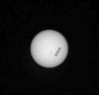
|
Posted by: jvandriel Sep 21 2012, 06:23 PM
Sol 45 NRA Panorama Jake Matijevic.
Jan van Driel

|
Posted by: kenny Sep 21 2012, 06:26 PM
I really don't think so. The ventifacts we saw before (like when Spirit was on the rim of Bonneville crater) were all extremely smooth.
Posted by: dvandorn Sep 21 2012, 09:53 PM
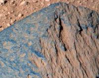
So... the melty-looking layers have rounded protuberances, but not spheroid. Well, as I said, we'd know more once we got some better-resolution images of Jake. And now we do.
Boy -- those layers are interesting. They can't have formed in the orientation that Jake is currently sitting, and yet the ragged edges of the layers almost appear to have flowed down the side of the rock. Has to be some trick of aeolian erosion. But this is obviously not a dense piece of lava, like the standard ventifacts we see elsewhere in the area and on Mars in general. As has been pointed out, they erode to smooth surfaces. And this thing has sat there long enough to erode down to a pyramid shape, so it has to have something to do with the actual physical strength of the rock faces and the differential strength of the different layers.
-the other Doug
Posted by: Stu Sep 21 2012, 11:22 PM
Beautiful 3D view across the crater floor looking towards the mountains...
http://twitpic.com/ax0s8q/full
Posted by: Jam Butty Sep 21 2012, 11:45 PM
At last, some nice colour stereo images to play with.
Top half of Jake, sol 44 flicker gif...

|
The flicker video version...
http://youtu.be/okejxh9STmU
Posted by: Actionman Sep 21 2012, 11:47 PM
I'm not sure if this makes any sense
I was going to use that as a source for color of the premises as well

But some how purple just doesn't seem like the right color, going to double check the time of day

Posted by: Ant103 Sep 22 2012, 12:11 AM
Sol 45 Navcam pan. Late afternoon, just like I like . Very temporary, still miss some frames.
http://www.db-prods.net/marsroversimages/Curiosity/2012/Sol45_pano.jpg
Posted by: Stu Sep 22 2012, 12:19 AM
How Ansel Adams might have photographed the mountains of Gale Crater...

|
Posted by: iMPREPREX Sep 22 2012, 12:56 AM
Ok, folks. The bottom 2 images of Jake just came in. Nice rock.

|
Posted by: mhoward Sep 22 2012, 01:49 AM
A color anaglyph with the additional images. http://www.flickr.com/photos/marscat/8010772219/sizes/o/in/photostream/
http://www.flickr.com/photos/marscat/8010772219/
Posted by: dvandorn Sep 22 2012, 01:51 AM
You know what? I'd bet you any money that for much of its existence on the surface, the right side (from our current position) of Jake was buried. The left side has been exposed for far, far longer. Notice how the far right edge bulges out, has not been "planed" down to a smooth edge as the left side has. And there is an entirely different (and more representative of the type) erosion rind on the left side than the jagged, "melting" appearance we see on the right side.
-the other Doug
Posted by: atomoid Sep 22 2012, 02:27 AM
To a non-geologist, the 'melty' right half of Jake really looks like dead-ringer for lava tube ceiling, can we rule out basaltic? (no, not suggesting 'lava tube fragmentation by explosive CO2 outgassing' whimsy).
Posted by: Ant103 Sep 22 2012, 02:33 PM
Here come some stereo !
Crossed-eyes :
http://www.db-prods.net/marsroversimages/Curiosity/2012/Sol44_Mastcam100_34_Xeyes.jpg
And anaglyph :
http://www.db-prods.net/marsroversimages/Curiosity/2012/Sol44_Mastcam100_34_ana.jpg
Posted by: Ant103 Sep 22 2012, 03:20 PM
The arm inspecting the rock in crossed-eye view.

|
Posted by: ronald Sep 22 2012, 03:23 PM
Nice crossed-eyes!
MAHLI closeup Anaglyph:

|
Posted by: Eutectic Sep 22 2012, 04:01 PM
Looks to me like a vesicular basalt.
Regarding the question of whether wind can erode a "melty" surface, this image from the USGS and Wikipedia suggests it can; not all ventifact surfaces need be smooth.

|
http://en.wikipedia.org/wiki/File:Mendenhall_1905_USGS.jpg
Posted by: climber Sep 22 2012, 05:18 PM
Let see if we hit the Jake Pot
Posted by: PDP8E Sep 22 2012, 05:26 PM
Hey Sundial!
Don't make any sudden moves!
ChemCam is pointing a laser at you!

|
(sol45)
Posted by: Jam Butty Sep 22 2012, 05:59 PM
Yet more Jake...
Mastcam L/R sol 44
flicker video...
http://youtu.be/MBV6c0PgGKw
flicker gif

|
Posted by: Joffan Sep 22 2012, 07:21 PM
For a plain ol' piece of Martian basalt, Jake is definitely giving good value for the attention spent on it.
I wonder if MAHLI is going to reach over to take some far side pictures? Or use its light to look inside some of those deeper dimples?
Posted by: jmknapp Sep 22 2012, 08:05 PM
In the most recent telecon a reporter asked about the probable history of a such a rock, how it would come to be sitting there like that. Dr. Grotzinger replied, IIRC, that their working assumption for rocks like that is that they're impact ejecta (is that still called basalt?) and remain on the surface because they're harder than the surrounding rock.
As a first run of the surface science instruments it's probably good that it's somewhat ordinary, to provide a baseline check.
Posted by: neo56 Sep 22 2012, 08:08 PM
Animation of Jake being analysed by the arm.

|
Posted by: JTN Sep 22 2012, 10:52 PM
Thanks. But my eyes are having trouble parsing that image. It makes more sense to me if I turn my glasses round -- that makes it have a bunch of bright ridges and edges lit from above, with sand collected in shallow depressions -- implying L/R may have been swapped.
But I could just about believe it's actually a convex bobbly texture, if I instead flip the image vertically so that the lighting for that would appear to come from above. (Could close-in MAHLI images end up taken with the camera "upside-down", if geometry is awkward?)
Looking at colour images on the raws site (e.g., http://mars.jpl.nasa.gov/msl-raw-images/msss/00046/mhli/0046MH0010001001E1_DXXX.jpg), I'm more inclined to believe the former interpretation.
(I don't think we actually can tell for certain which interpretation is correct, from the data we have? -- stereo pairs of MAHLI images are taken by moving the arm, so without pointing information we don't know which is really the "left" one. So we have to guess based on image content, I think?)
Posted by: Jam Butty Sep 23 2012, 12:51 AM
My take on the MAHLI stereo from sol 46
flicker gif...

|
and the vid... http://youtu.be/J_i2sVajrLA
Posted by: jmknapp Sep 23 2012, 01:22 AM
So where on Jake are the MAHLI photos coming from? This treatment show the dust particles pretty well:

|
Gotta love the hand lens.
Posted by: dvandorn Sep 23 2012, 02:03 AM
MAHLI is an amazing instrument. Color carries so much information, so having as good or better resolution from MAHLI as we got from the MER MI and the color information to boot is really, really satisfying.
Now, a lot of people seem to have made up their minds that this is a chunk of basalt, but MAHLI shows very tiny vesicles in the rock matrix, much smaller than the large holes which look less like vesicles and more like places where clasts have dropped out of the rock. It's somewhat unusual to have two widely diverse vesicle sizes in a single chunk of lava -- do we have ChemCam information that definitely shows this rock as a chunk of basalt? Not just basaltic (since the base material of the matrix could well be basaltic, even if it's cemented sedimentary rock or even impact melt), but actual, unaltered pyroxene or olivine?
I'm looking forward to hearing about the composition of Jake. Should provide some good insights.
-the other Doug
Posted by: Bill Harris Sep 23 2012, 05:53 AM
Yep, ChemCam and the other tools will sort out the puzzle-pieces in short order. I'l like to learn the mineralogy of the Ubiquitious Ochre Martian Dust. I informally tend to think of it as "limonitic", but who knows...
Posted by: dvandorn Sep 23 2012, 05:59 AM
The turret is brought to bear!

|
-the other Doug
Posted by: ronald Sep 23 2012, 06:54 AM
I'm sorry, but for me it works. Red filter for the left eye ...

Posted by: jmknapp Sep 23 2012, 12:09 PM
Might there be some perchlorate in there (as seen by Phoenix)? When APXS analyzed the (dusty) calibration target on sol 35 it did pick up a signal for chlorine.
From Alan Boyle's http://cosmiclog.nbcnews.com/_news/2012/09/12/13832113-mars-rover-uses-its-x-ray-vision?lite:
Here's a cross-eyed MAHLI 3d detail:

|
Posted by: Ant103 Sep 23 2012, 02:04 PM
Maybe it will usefull to put some of the "Jake Matijevic" stuff in one picture, like a tour ?
http://www.db-prods.net/blog/2012/09/23/le-rocher-jake-matijevic/
Board size is about 6.8 Mo. I can't be more accurate to place the MAHLI overlay on the Mastcam100 mosaic. It's quite hard to find the corresponding place.
Posted by: dvandorn Sep 23 2012, 02:23 PM
Well... I know that Oppy has seen an awful lot of trace elements in the Meridiani soils and rocks, including sulfur, chlorine, arsenic and even carbon (though Phoenix was much more well-suited to identify carbon). As I recall, Phoenix found more carbonates in the soil than it found perchlorates.
I know it's always dangerous to judge Martian processes based on Terrestrial processes. But the various exotic admixtures we see in the Martian soils are roughly what I would expect if bodies of very salty water evaporated, leaving the easily soluble elements and minerals as evaporites which were then well-mixed by impact, volcanic and aeolian processes into the rocks and soils over megayears.
-the other Doug
Posted by: Bill Harris Sep 23 2012, 02:49 PM
As a terrestrial-trained geologist, my first thought when I see "the Martian Ochre" color is "limonitic" since that is my experience. But after years of kicking around Mars vicariously, I know that it is not likely to be as simple as Fe2O3 (xH2O). But with aeons of aeolian mixing and distribution of the micron (or sub-) sized dust particles, I wouldn't be surprosed if there is a narrow range in composition. OTOH, I would expect soil types and compositions to differ from region to region based on the mineralogy of the parent material.
--Bill
Posted by: Phil Stooke Sep 23 2012, 03:47 PM
I really like the tour of Jake posted by Ant103 just above. First of many, I hope. A really good way to add value to the raw images.
Phil
Posted by: Nix Sep 23 2012, 05:01 PM
Yes, your 'tour' est très cool Damien
Posted by: stewjack Sep 23 2012, 05:03 PM
Phil
I just noticed the landmark Rocky Point (my name) all the way on the left of the panorama. That should be a landmark that will be visible from many locations on MSL's travels.

|
Posted by: marsophile Sep 23 2012, 05:39 PM
[Gellert:] ... sodium and chloride...
That appears to be an error. It seems clear from the rest of the article and the graph that it was sulfur and chlorine.
Posted by: climber Sep 23 2012, 06:32 PM
Yep, we'll probably see it for a loooong time! Kinda Beacon, eh?
Posted by: ngunn Sep 23 2012, 06:45 PM
Is Rocky Point the prominent dark spot upper left of centre here? http://www.unmannedspaceflight.com/uploads/post-253-1346962019_thumb.jpg
If not perhaps someone can identify it correctly on HiRise??
Posted by: fredk Sep 23 2012, 07:00 PM
Here's "Rocky Point", from Phil's route map:

|
Posted by: Ant103 Sep 23 2012, 07:21 PM
Thank you
Yes, I will do this if necessary, or just by pleasure, of course .
Posted by: fredk Sep 23 2012, 07:26 PM
6 unaligned frame animation of Deimos transit (1px Gaussian blur):
|
Posted by: Stu Sep 23 2012, 08:48 PM
Fanciful view of low Sun at Gale...

|
(and yes, I know the pointing isn't 100% accurate, it's art, not scientific!
)Posted by: ngunn Sep 23 2012, 09:11 PM
I like that one a lot. Bluish low sunlight, dark brown shadows, just right I think. VERY good Stu. I really appreciate these 'artist's impressions' - wish you'd do more.
EDIT: Thanks also to fredk for confirming the ID of Rocky and to Ant103 for the great poster.
Posted by: Joffan Sep 24 2012, 03:43 AM
Board size is about 6.8 Mo. I can't be more accurate to place the MAHLI overlay on the Mastcam100 mosaic. It's quite hard to find the corresponding place.
That's a great idea. However I think the larger MAHLI image (with the shadow on) is out of position in your montage. The pit near the top of Jake, top-left of the MAHLI image, looks correct, but the MAHLI image is rotated far more, another 60+degrees clockwise.
|
I can't overlay very well because the rock surface is nowhere near flat, so no simple transform will distort one image onto the other.
(Edit: Ant103 has updated the montage)
Posted by: Stu Sep 24 2012, 08:06 AM
Great composition.... Art on Mars... Love it...
|
(From a new blog post, if anyone wants a read... http://galegazette.wordpress.com/2012/09/24/the-art-of-mars )
Posted by: jmknapp Sep 24 2012, 10:11 AM
On Mars, the glass is always half full of carbonates, but could MER detect perchlorate as such? MSL is able to, per this http://www.space.com/6573-mars-sprinkled-salty-mysteries.html item:
Intriguingly, the Viking landers detected chlorine at their landing sites, which were closer to the Martian equator than Phoenix's site. The landers couldn't determine what compound that chlorine came from, but it could have been perchlorate, [Phoenix co-investigator Dr. Raymond] Arvidson said.
"Now we have a specific compound to search out and find" when MSL, which will also explore more mid-latitude sites, lands on the planet, he said.
Chemcam, using laser-induced breakdown spectroscopy (LIBS), particularly can identify perchlorate salts according to http://www.lpi.usra.edu/meetings/lpsc2011/pdf/1912.pdf.
Posted by: belleraphon1 Sep 24 2012, 12:10 PM
(and yes, I know the pointing isn't 100% accurate, it's art, not scientific!
)Love the fanciful views as well ................
One of the strengths of this forum is the ability of folks to create 'fanciful' views which the science teams (rightly) cannot do.
Keep it up Stu.
Craig
Posted by: Ant103 Sep 24 2012, 12:38 PM
Thank you for your help Joffan I have a better overlay now. See my http://www.unmannedspaceflight.com/index.php?s=&showtopic=7471&view=findpost&p=191964. It's not yet perfect, because as you said, the surface of Jake is not flat, and so, it needs some complex distorsions. But it's more accurate now I think .
Posted by: fredk Sep 24 2012, 02:42 PM
Sol long Jake...
http://mars.jpl.nasa.gov/msl-raw-images/proj/msl/redops/ods/surface/sol/00048/opgs/edr/ncam/NLA_401759030EDR_F0042634NCAM00307M_.JPG
Posted by: fredk Sep 24 2012, 03:07 PM
Very nice early morning navcam sequence from sol 44 coming down:
http://mars.jpl.nasa.gov/msl-raw-images/proj/msl/redops/ods/surface/sol/00044/opgs/edr/ncam/NLA_401372650EDR_F0042002NCAM00517M_.JPG
|
Posted by: jmknapp Sep 24 2012, 03:27 PM
I wonder how much skyglow there is just before the sun comes up. By my calculations this shot was taken a few minutes before the sun came up (assuming a 0 degree horizon):
http://mars.jpl.nasa.gov/msl-raw-images/proj/msl/redops/ods/surface/sol/00044/opgs/edr/ncam/NLA_401372390EDR_F0042002NCAM00517M_.JPG
There aren't strong shadows in that image, so the illumination must be coming from sky glow--still very well lit.
This shot was taken a couple minutes later:
http://mars.jpl.nasa.gov/msl-raw-images/proj/msl/redops/ods/surface/sol/00044/opgs/edr/ncam/NLA_401372477EDR_F0042002NCAM00517M_.JPG
It still seems as if the sun hasn't quite cleared the horizon, yet everything is pretty well illuminated, even the distant hills facing away from the sun.
Posted by: fredk Sep 24 2012, 03:33 PM
I think skyglow is pretty much all we're seeing this close to sunrise. Remember the MER sunset images - dust absorption is so strong that light scattered from the sky totally dominates over direct sunlight. That makes it hard to see long shadows.
Posted by: ngunn Sep 24 2012, 03:57 PM
Right, so no frost this morning.
Posted by: Doc Sep 24 2012, 03:59 PM
Leaving Jake forever behind
|
ADMIN: Removed inline image. Plese refer to http://www.unmannedspaceflight.com/index.php?act=boardrules 3.2
Posted by: Doc Sep 24 2012, 04:03 PM
Lovely view, someone ought to colourize it.
Posted by: Stu Sep 24 2012, 05:12 PM
Oh, look at that...
|
|
...and that's just a cropped raw, not messed about with.

Posted by: EdTruthan Sep 24 2012, 05:19 PM
Z-axis addicted I am. Seems like all I do of late is check for overlapping MC100's with good baseline differentials. The seven frames just down from Sol 42 overlap with a few frames from Sol 36 of the N. Mt. Sharp foothills. My jaw just dropped when I split the red-blue bands on this one:
http://www.edtruthan.com/mars/Sol36-and-42-North-Mt.-Sharp-Foothils-Anaglyph-4519x1136.jpg
Posted by: akuo Sep 24 2012, 08:00 PM
Measuring from the http://www.unmannedspaceflight.com/index.php?s=&showtopic=7442&view=findpost&p=192018, it looks like tosols drive was almost 40 metres. Speeding up
Posted by: Ant103 Sep 24 2012, 08:41 PM
I just LOVE these dusk (or dawn) panoramas.
http://www.db-prods.net/marsroversimages/Curiosity/2012/Sol44_pano.jpg
But these stretched images are ruining it. Sorry to make it a fix idea, but this was a really bad idea…
Panorama edited to correct some exposure and stitching things.
Posted by: Phil Stooke Sep 24 2012, 09:27 PM
A circular version of Ant's panorama from sol 44. I stretched it as I prefer for feature visibility.
Phil
|
Next stop - a fine-grained drift for testing the sampling system and other instruments... it's interesting that there are so few dust drifts here compared with other sites. Spirit would have passed dozens of big drifts by now.
Posted by: elakdawalla Sep 24 2012, 09:48 PM
Pardon the interruption but I wanted to point out that it's time to raise the money it takes to keep unmannedspaceflight.com going. http://www.unmannedspaceflight.com/index.php?showtopic=7479, or http://planetary.org/support-umsf.
Posted by: Oersted Sep 24 2012, 10:50 PM
But these stretched images are ruining it. Sorry to make it a fix idea, but this was a really bad idea
Panorama edited to correct some exposure and stitching things.
This pan is a magnificent tribute to (the person) Jake.
Posted by: jmknapp Sep 25 2012, 12:01 AM
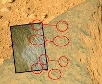
So there are some white/shiny grains in or on Jake--from mahli:

|
Hope chemcam & apxs got good looks.
Posted by: nprev Sep 25 2012, 01:05 AM
Just an impression, and based on my record it's almost certainly wrong...looks for all the world like an iron/nickel meteorite in this shot to me.
Posted by: Ondaweb Sep 25 2012, 01:22 AM
I can sure see why you say that, but it's hard to believe they wouldn't get a chemcam reading before doing the rest of the work and they did want a basalt.
Posted by: jmknapp Sep 25 2012, 01:31 AM
Hey now--that would account for some meltiness. Here's an Fe/Ni meteorite from Australia:
|
Also the large amount of dust adhering?
Another photoshop-tortured treatment:
|
Question about the couple of cracks seen emanating up from the base: wouldn't a hard rock tend to fracture all the way through rather than stopping like that?
Posted by: CosmicRocker Sep 25 2012, 03:40 AM
They really help to interpret the unconformities and structures within the layers of Mount Sharp.Posted by: drz1111 Sep 25 2012, 03:48 AM
Vesicles (sp?) and a glassy or sand-polished exterior can make basaltic volcanics into a dead ringer for a meteorite with a fusion crust. No way that can be IDed from a photo alone.
Posted by: mvanooijen Sep 25 2012, 11:41 AM
Just for a split second I misread your post as "Lovely view, someone ought to colonize it..."

Posted by: akuo Sep 25 2012, 02:42 PM
Sol 49 drive imaging is up, only about 2h after the fact on Mars. Looks like a rock garden: http://mars.jpl.nasa.gov/msl-raw-images/proj/msl/redops/ods/surface/sol/00049/opgs/edr/ncam/NLA_401848397EDR_F0042778NCAM00409M_.JPG
Posted by: fredk Sep 25 2012, 02:59 PM
Definitely starting to look interesting as we approach Glenelg. Sol 49 anaglyph:
|
Posted by: climber Sep 25 2012, 03:09 PM
I'm starting to think that when Alan Chen said "we've found a nice spot place (for landing)" he was right after all
Getting rough now
Posted by: EdTruthan Sep 25 2012, 03:25 PM
Rough terrain it is... Hazcam from about 3 hrs ago....(Sol 49)...
|
Posted by: stewjack Sep 25 2012, 04:50 PM
That depression, straight ahead, might have some fine grained soil that Curiosity could eat. If it is time for her first meal that is.
Jack
Posted by: fredk Sep 25 2012, 04:55 PM
Long baseline stereo view from sols 19 and 42 (there's some residual headachiness I couldn't get rid of):

|
Posted by: EdTruthan Sep 25 2012, 05:54 PM
Nice Fred, I almost did that one too as it's one of the few latter day MC100 overlaps from the Sol19 and 23 pans. I'm anxiously awaiting the hi-res versions of the Sol 45 MC100 full panorama of Mt. Sharp to pair with the Sol 23 pano to render the foothills to the south and the slopes above. With that baseline it will be stunning. A handful of the upper slopes came in today. Hoping the rest follow soon... In fact, I went ahead and stitched some of the Sol 45 thumbnails together just to do quick check of level of depth it would provide. It's a little wonky to view because the left eye's red band is quite blurry but it clearly confirms what kind of eye-popping results can be achieved with a Sol 23 & 45 pairing when the full 45's are down.
Here is my very rough and preliminary depth test (left eye is the Sol 45 thumbnail mosaic) :
http://www.edtruthan.com/mars/Sol23-and-45-Anaglyph-Test-(Sol45-thumbnails-left-eye).jpg
When the full resolution version of this can finally be rendered it'll be "chewing gum for the eyes"...
Posted by: climber Sep 25 2012, 08:10 PM
On today Mars program conference they announced that there will be a Televised Curiosity Science conference this Thursday at 2PM eastern. Stay tuned for Official announcement.
Posted by: Zeke4ther Sep 25 2012, 08:23 PM
An interesting article in http://www.informationweek.com/government/mobile/curiosity-rover-to-get-on-the-go-photo-c/240007783
Looks like there is a plan for Curiosity to get little sister Opportunity's AEGIS software capability.
Posted by: Ondaweb Sep 26 2012, 12:56 AM
In 9 to 12 months, Curiosity will be up in the highlands and probably not roaming long distances or over fields of rocks. Anybody know why not now when it would be most useful on the trek to the hills?
Posted by: Astro0 Sep 26 2012, 02:57 AM
"Anybody know why not now....." what?
1) Short drives to longer ones later during commissioning/early phases - drivers getting the hang of the vehicle characteristics in an 'alien' environment
2) Challenging terrain - rocks, craters, dust bowls etc
3) It'll take a year to actually get to the hills and there's lots of awesome geology and science inbetween
4) There are dunes and inverted terrain to cross first
5) They'll be climbing in difficult terrain when they do get there
6) Orbitial imagery suggests pretty dusty environs in the valleys, not quite so rocky as out on the plains
7) etc, etc
Am I hearing: "Are we there yet?!" from the backseat
Posted by: fredk Sep 26 2012, 02:59 AM
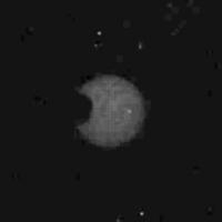
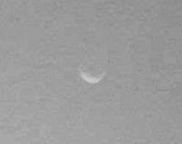
Some MR shots are down showing Phobos in the late afternoon sky - here's the best one I noticed:
http://mars.jpl.nasa.gov/msl-raw-images/msss/00045/mcam/0045MR0209002000E1_DXXX.jpg
Can anyone check to see the altitude of sun and Phobos at the time that was taken? It was taken around 5:30 pm LMST, so the sun was probably very low. Judging from the phase of Phobos, it's probably around 30 degrees from the sun.
Posted by: atomoid Sep 26 2012, 03:04 AM
Oh too bad they didn't build AEGIS in from the start!! im guessing it was on the planning board but shelved for perfectly reasonable reasons like risk to the development/launch schedule. But jamming a major upgrade into MSL's package in just 9-12 months does seem ambitious. though risk may seem minimal, unforseen complications and interactions with other elements of the system require vigilant pre-emption through extensive test planning and retesting under various conditions and its good engineering sense to plan on such tasks taking at least 4 times longer than you plan for (the last 20% takes 80% of the work!!)..
Mainly, im guessing they dont want to risk the 1 year "mission success" milestone for MSL and so would rather tack it on after the warranty runs out. As with MER (and i dont know how much testing it got before they popped v1.0 into Oppy), they would have still had a wildly successful 5+ years at 2009, so then if an unfortunate software upgrade croaked the platform, it wouldnt lead to a big media frenzy fiasco like MCO/MPL/DS1 and would have mostly lead to bored UMSF'ers waiting for MSL to touch down...safely..
Posted by: djellison Sep 26 2012, 03:39 AM
On what basis are you saying it's 'jamming'. You don't know how long AEGIS has been worked on at JPL for MSL deployment. You don't know when it started, what the schedule is like, what the testing plan is etc etc. You're talking as if the flight software engineers are morons.
They are not.
Posted by: Zeke4ther Sep 26 2012, 03:47 AM
...
Astro0, I believe Ondaweb was posing his question based on the article on the AEGIS software.
His point is, why are they going to wait 9 to 12 month (as per the article) to install the software, when
it would be more useful during the approach phase to Mt. Sharp; where we will start doing longer, autonomous, drives.
Posted by: walfy Sep 26 2012, 03:48 AM
http://mars.jpl.nasa.gov/msl-raw-images/msss/00045/mcam/0045MR0209002000E1_DXXX.jpg
OMG! I've never seen such an image, such a clear shot of an alien moon taken from the surface of another planet in which the moon is clearly outlined. I know images have been taken showing the other-worldly moons of Mars, and even distant Earth, as mere points of light, wonderful in their own way. But this is a first, is it not? I'm blown away by this image. It's like gazing up at our own moon, yet outrageously different with its not-so-circular crescent through an alien haze. As some on the team said after the first pics came down, the landing place looks familiar. This Phobos moon shot makes it more so. Alright, 'nuff said.
Posted by: Explorer1 Sep 26 2012, 04:04 AM
Yes, that makes Gale crater that much more familiar, and not just the bluish background!
All we need now is another Earthrise/set...
Posted by: fredk Sep 26 2012, 04:47 AM
Incredibly cool. And I don't recall any crescent view of Phobos from MER, though pancam certainly could resolve it.
And if you squint just right, maybe a crater on the terminator?
|
Back on the ground, I'm absolutely loving the sol45 MR sequence, showing the mesas with a lower sun than we've seen before. Plus now we've got the baseline we've been waiting for. Here's an anaglyph:

|
And side-by-side version:

|
Can't wait for a certain member to mosaic this...
Posted by: Astro0 Sep 26 2012, 04:49 AM
"...posing his question based on the article on the AEGIS software."
Helps if that was included in the question.
Still stand by my reply.
Back seat driving is not what we need here.
They do drives and software upgrades and everything else at the pace they'll do it, when they're ready and as the situation allows.
Enjoy the ride!
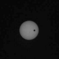
Posted by: volcanopele Sep 26 2012, 05:33 AM
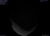
Here are some screen shots from Celestia of Phobos at the time. Looks like the image was taken shortly after sunset.

|
|
Posted by: vikingmars Sep 26 2012, 08:27 AM
...and if you look very carefully, you can even see an hint of the reflected light from Mars on the night side of Phobos...
Here are 2 quick enhancements, just to show you that the effect is real and not the result from a processing artifact :
1. the "crude" view

2. a more "more natural" view with the equalizing of gray values.
|
Enjoy
Posted by: James Sorenson Sep 26 2012, 08:36 AM
Popping out from under a rock! Here is the Sol-45 right Mastcam view of Mount Sharp. A few images are missing still.
http://www.flickr.com/photos/43581439@N08/8025940300/
Posted by: EdTruthan Sep 26 2012, 10:36 AM
"Humongous Anaglyph III"
Sol 45 and Sol 23 MC100 with a 210 meter wide baseline... Yup. Elvis has now left the building...
20016x2267px 6.85MB
http://www.edtruthan.com/mars/Sol45-and-23-Mt.Sharp-Foothills-Anaglyph-Panorama-20016x2267.jpg
The times of day were different, so the shadows are a bit mis-matched, and with such a wide baseline, getting the correct red-blue separation is tricky because close and far objects require lots of eye adjustments. But I could tweak for weeks. Better to share....
Posted by: ronald Sep 26 2012, 11:09 AM
I couldn't resist - two croppings from the Sol 45 pan:

|

|
Posted by: Astro0 Sep 26 2012, 12:16 PM
Stunning!
Posted by: Nix Sep 26 2012, 12:47 PM
Sol 45 and Sol 23 MC100 with a 210 meter wide baseline... Yup. Elvis has now left the building...
20016x2267px 6.85MB
-IMG-
The times of day were different, so the shadows are a bit mis-matched, and with such a wide baseline, getting the correct red-blue separation is tricky because close and far objects require lots of eye adjustments. But I could tweak for weeks. Better to share....
Monster anaglyphs could indeed take weeks to tweak.... just a small preview for now

http://imageshack.us/photo/my-images/821/sharpanaglyph.jpg/
what glorious views we're getting these past sols !
Posted by: Phil Stooke Sep 26 2012, 01:48 PM
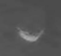
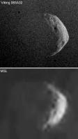
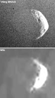
The Phobos image reminded me of an early Viking image:
|
There are some messy JPG artifacts, but a couple of craters are certainly real.
Phil
Posted by: algorimancer Sep 26 2012, 01:48 PM
Given a couple of shots like that, allowing a few degrees of motion between them, I could even envision a stereoscopic perspective of Phobos -- that would be very cool.
Posted by: Ant103 Sep 26 2012, 02:37 PM
It missing just 3 frames to be complete, but WOW.
http://www.db-prods.net/marsroversimages/curiosity.html#sol45
Ed : amazing work on these anaglyph !
Posted by: vikingmars Sep 26 2012, 02:49 PM
Thanks a lot Phil for having found this VO pic !
And there is a good "fit" for its global shape on its night side too with the reflected light from Mars (see enhancement herebelow) :
|
Plus a link to the "Ciel & Espace" website where the image was published this morning (CET) in France :
http://www.cieletespace.fr/node/9592
Enjoy
Posted by: MahFL Sep 26 2012, 03:14 PM
Re Ageis....It's a good idea to get the normal, extremely complicated surface s/w working well, before adding on enhancements, bare in mind, if luck holds out MSL will last more than 10 years. Also long drives will still be posible in the hills, those hills are massive, not "molehills" you can drive around or over in a day.
Posted by: fredk Sep 26 2012, 03:59 PM
Sol 45 and Sol 23 MC100 with a 210 meter wide baseline... Yup. Elvis has now left the building...
About marsshine on Phobos, I'm skeptical considering all the blocky jpeg artifacts in the sky. But the thought is really interesting. Mars would look huge from Phobos, much bigger than the Earth from the Moon. So if the geometry is right, the marsshine could be very bright. It's hard to see earthshine on the Moon unless the sky is quite dark. But it could be much easier to see marsshine on Phobos...
(Emily - according to Joe's site, the Phobos image was taken at 17:27 LMST, not near local noon. That's consistent with it's orientation at sunset.)
Posted by: mhoward Sep 26 2012, 04:01 PM
Goodness, those images of Phobos are really something.
Sol 50. Looks like we're actually quite close to the edge of the especially interesting terrain. The view after the next drive should be good.
http://www.flickr.com/photos/marscat/8026905873/ http://www.flickr.com/photos/marscat/8026904649/
Posted by: Phil Stooke Sep 26 2012, 04:23 PM
Sol 49 panorama in circular form - to help me with rover location.
Phil
|
Posted by: Ant103 Sep 26 2012, 04:49 PM
Sol 49 late afternoon panorama.
http://www.db-prods.net/marsroversimages/Curiosity/2012/Sol49_pano2.jpg
And this gave me the need to do a postcard picture with some more sky .
http://www.db-prods.net/blog/2012/09/26/cest-la-fin-apreme-a-gale/
Posted by: Reckless Sep 26 2012, 05:50 PM
MSL Science update on NASA TV Thursday 27th September at 11 am PDT
Roy
Posted by: Phil Stooke Sep 26 2012, 06:33 PM
Just looking back at the Phobos images from sol 45... I thought it might be useful to combine the two best images to reduce JPG noise... but it looks like there is too much rotation of Phobos (and/or the terminator) for that to work.
PS my daughter informs me that I use too many ...s in my emails to her. I have decided to move them all here instead... enjoy! ...
Phil
Posted by: ronald Sep 26 2012, 08:16 PM
Stitched out of 12 Mastcam 34 mm images - Sol 49:

|
http://dl.dropbox.com/u/5875127/msl/0049MR0219005000E1_DXXX-0049MR0219027000E1_DXXX_post.jpg
Nice texture on the stones and rocks!
And a second-but-not-so-impressive one:

|
http://dl.dropbox.com/u/5875127/msl/0049MR0224000000E1_DXXX-0049MR0224013000E1_DXXX_post.jpg
Posted by: fredk Sep 26 2012, 08:24 PM
Anyway, we can hope for cleaner images in the press release tomorrow...
Posted by: vikingmars Sep 26 2012, 08:52 PM
.How nice Damien ! Thanks a lot and cheers
Posted by: stevesliva Sep 26 2012, 09:15 PM
Tell her ellipsis are important in planetary science.
Posted by: Phil Stooke Sep 26 2012, 09:33 PM
That's right... Kepler invented them, I believe.
Phil
Posted by: Ian R Sep 26 2012, 10:56 PM
BREAKING NEWS ... this thread has made it to Fark:
http://www.fark.com/comments/7348466/Old-busted-Crescent-Moon-as-seen-from-Earth-New-hotness-Crescent-Phobos-as-seen-from-Mars-rover-Curiosity
Posted by: Explorer1 Sep 26 2012, 11:10 PM
It wasn't me, I swear! I just lurk...
Not on the main page at least.
Posted by: Eyesonmars Sep 27 2012, 02:18 AM
Phil
Applying your reasoning and examples to what we see at Mt. Sharp it would seem highly unlikely that any of the layers we see were deposited by a fluid. Any comments folks ?
(I suppose since our primary goal is the underlying phyllosilicates this is not of primary interest.)
On the other hand on Emily's webcast today she showed what appeared to be a channel which turned into an inverted delta(somewhere near Mt. Sharp). It would be interesting to see this on a countour map. When I saw Emily's image I immediately thought of the fluvial like channels on the interior crater walls that turned out to be not quite the proof of running water on mars that we at first thought.
Posted by: stewjack Sep 27 2012, 02:45 AM
I present you with an anaglyph of a rock. From Left & Right SOL 50 NAVCAMS
Link to Right NAVCAM image
http://mars.jpl.nasa.gov/msl-raw-images/proj/msl/redops/ods/surface/sol/00050/opgs/edr/ncam/NRA_401936950EDR_F0042956NCAM00435M_.JPG
It is not even a great anaglyph. As it stands it seems to me to me to have the suggestion of an outer crust. However, I may be reading to much into nothing but blurry shadows. If someone with more skill is also intrigued perhaps they could improve the Navcams.
EDIT Never-mind! I found a 2nd DOWNSAMPLED NAVCAM view that presents a different lighting situation. It now looks like a normal rock.
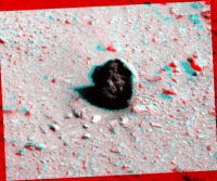
|
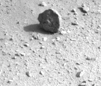
|
Posted by: Phil Stooke Sep 27 2012, 02:58 AM
I was talking generally about vertical settling of particles from a surrounding medium - mud from water, dust from air - that's a fluid (not a liquid). So for instance, layer after layer of volcanic ash from Tharsis could be draped across the landscape, mimicking its topography in the local slope of each layer.
Phil
Posted by: ronald Sep 27 2012, 08:23 AM
Hazcam Sol 50:

|
Three in a row
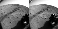
|
Posted by: Ant103 Sep 27 2012, 01:23 PM
Sol 50 Navcam pan.
http://www.db-prods.net/marsroversimages/Curiosity/2012/Sol50_pano.jpg
*roll roll roll* "Are we there yet ??"
Posted by: craigmcg Sep 27 2012, 01:32 PM
It will be interesting to see how much relief there is in this section.

|
Posted by: Phil Stooke Sep 27 2012, 01:36 PM
Circular view of Ant103's pan (I may have exaggerated the width of the gap).
Phil
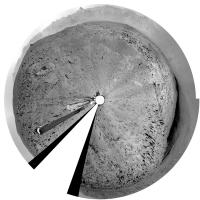
|
Posted by: OWW Sep 27 2012, 02:53 PM
Hard to see in the Navcam images, but some of those layered rocks nearby look a lot like those around Homeplate.
Posted by: fthurber Sep 27 2012, 03:00 PM
Will today be the day we hear some results from the SAM TLS methane investigation? It has been put off for a few weeks so I have to believe that something important has happened. I would think these are the possible results:
- No methane detected.
- Methane detected but it may be contaminated with methane vaporising off plastics or glues on MSL.
- Methane detected but not enough to get isotope ratios.
- Methane detected and isotope ratios suggest abiotic origins.
- Methane detected and isotope ratios (enhanced C12) suggest biotic origins.
Posted by: fredk Sep 27 2012, 03:08 PM
There are lots of very little ripples around us now. I wonder if they can use one of these for the scoop test...
Posted by: paraisosdelsistemasolar Sep 27 2012, 03:27 PM
Hi to everybody,
With the last frames received from Sol 42, Deimos transit looks amazingly smooth!
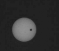
|
Posted by: toddbronco2 Sep 27 2012, 03:43 PM
You can see the rotation of Deimos? I don't think that is the case because Deimos is tidally locked.
Posted by: Hungry4info Sep 27 2012, 03:45 PM
Agreed. I think you're seeing JPEG noise.
Posted by: ceramicfundamentalist Sep 27 2012, 03:45 PM
was there a consensus as to whether the dark blotch just below the centre of the sun is a sunspot? it looks pretty convincing from these images.
Posted by: fthurber Sep 27 2012, 05:50 PM
Yup! And it was a little depressing that many of the reporters from the major networks just wanted to hear about malfunctions right after EDL. They were practically begging for bad news.
Some reporters ask dodgy questions but some ask really good questions. I know that it is going to be an informed question when I hear that it is Emily Lakdawalla or Irene Klotz from Reuters. Nadia Drake from Science News and Joe Palca from NPR also ask good questions. Leo Enright from Irish TV and Emily ask the most entertaining questions.
Posted by: Explorer1 Sep 27 2012, 06:00 PM
Conference starting now....
Posted by: Explorer1 Sep 27 2012, 06:04 PM
Water already, wow!
Posted by: djellison Sep 27 2012, 07:14 PM
Your options basically are 'SAM may or may not have detected methane'. Isn't that fairly obvious?
If some startling revelation were found, they would have a press conference about it when they were confident in the results. If there were something up with SAM they would ( as with REMS ) let us know.
No news isn't bad news or good news.
Posted by: Nix Sep 27 2012, 08:08 PM
Mount sharp sol 45 & sol 23 partial color/anaglyph right-click the panorama for full-resolution download.
http://elysium.zenfolio.com/p400916519/h44C3C7D4#h44c3c7d4
edit: high-contrast version added
Posted by: stewjack Sep 27 2012, 08:57 PM
Something is wrong.
I was only able to download a 47 byte file labeled null.gif
Posted by: vikingmars Sep 27 2012, 09:56 PM
Well... I'm late in my processings because I have hectic days with late evening intl' conf-calls...
Here is my interpretation of Sol 44 dawn panoramic NavCam pics. Enjoy

|
Posted by: Nix Sep 27 2012, 10:57 PM
more food for the anaglyph lover, the rest of sol 23 'filled in', in grayscale red/cyan for detail and contrast - unsharpened
back to work for the rest of the mountain here
http://elysium.zenfolio.com/p400916519/h44C3C7D4#h44c87d2c
Posted by: Jam Butty Sep 27 2012, 11:47 PM
'Hottah' , the water-formed conglomerate discussed in todays news conferrence,
from sol 39...
a flicker video http://youtu.be/eFuj-ek9T2Y
a flicker gif

|
and a crossed pair

|
Posted by: jmknapp Sep 28 2012, 12:03 AM
If they're looking for a warmer, wetter planet, they're getting hottah.
Posted by: climber Sep 28 2012, 12:10 AM
So, after Huygens, that's the second time we landed in a stream/river or whatever it was.
Posted by: Explorer1 Sep 28 2012, 01:06 AM
And the first where the liquid was water too.
Posted by: Don1 Sep 28 2012, 05:25 AM
Some of the geologists deserve a few beers, because what the rover found is pretty much what they predicted was there based on orbiter images.(Anderson + Bell, 2010, Geologic mapping and characterization of Gale Crater and implications for its potential as a Mars Science Laboratory landing site )
When that stuff finally gets drilled and fed to the lab there should be a really interesting story to tell about the chemistry of the water and maybe even organics. It looks a lot different from the Meridiani material, so maybe the water here was less acidic.
If water was flowing down into this area, shouldn't there be a dried up lake bed somewhere? Like maybe at Glenelg?
Posted by: James Sorenson Sep 28 2012, 06:19 AM
Here is a thumbnail version of the Sol-50 panorama.
http://www.flickr.com/photos/43581439@N08/8031998743/
Posted by: kenny Sep 28 2012, 11:10 AM
Love it! Especially in an upper class English accent...
Posted by: Phil Stooke Sep 28 2012, 11:22 AM
Looks like no drive on sol 51, but some arm flexing for testing sample delivery instead. Should be a drive today (from Scott's tweet).
Phil
Posted by: fthurber Sep 28 2012, 01:41 PM
I seem to remember that the plan was to land Mars Pathfinder in an outwash / alluvial area but I don't remember Pathfinder / Sojourner detecting any waterborne sediments except to note that the rocks were sightly tilted in direction.
Posted by: Ant103 Sep 28 2012, 01:47 PM
And 100mm "thumbail" pan :
http://www.db-prods.net/marsroversimages/Curiosity/2012/Sol50_Mastcam100_thumb.jpg
Powered by Invision Power Board (http://www.invisionboard.com)
© Invision Power Services (http://www.invisionpower.com)