Rhea Flyby (november 26th 2005.) |

 Unmanned Spaceflight.com > Outer Solar System > Saturn > Cassini Huygens > Cassini's ongoing mission and raw images
  |
Rhea Flyby (november 26th 2005.) |
 Nov 14 2005, 03:56 PM Nov 14 2005, 03:56 PM
Post
#1
|
||
 Member  Group: Members Posts: 648 Joined: 9-May 05 From: Subotica Member No.: 384 |
26 Nov. Close Flyby (500 km.) of Rhea...(Size: 1538 km.)
27 Nov. Distant Flyby (108,000 km.) of Enceladus...(Size: 512 x 494 x 490 km.) 27 Nov. Distant Flyby (86,000 km.) of Helene...(Size: 36 x 32 x 30 km.) This should be interesting...  Can anybody give a bit more information on the upcoming flybys??? Is this the best image of Helene that we have??? Vojager 2 - distance :341000 km)
-------------------- The scientist does not study nature because it is useful; he studies it because he delights in it, and he delights in it because it is beautiful.
Jules H. Poincare My "Astrophotos" gallery on flickr... |
|
 |
 
|
|
|
Nov 14 2005, 04:50 PM
Post
#2
|
|
|
Member Group: Members Posts: 903 Joined: 30-January 05 Member No.: 162 |
Perhaps Helene is a former satellite of Dione, liberated form Dionian grasp by tidal effects long ago?
Rhea flyby should be interesting. Comparisons with Iapetus are fascinating considering their similar mass, and yet wildly dissimilar surfaces. Does the Enceladus flyby 'fill in the gaps' for global coverage? Thanx for the timely post. |
|
|
|
|
Nov 14 2005, 06:37 PM
Post
#3
|
|
 Senior Member Group: Members Posts: 1465 Joined: 9-February 04 From: Columbus OH USA Member No.: 13 |
QUOTE (Toma B @ Nov 14 2005, 11:56 AM) 26 Nov. Close Flyby (500 km.) of Rhea...(Size: 1538 km.) 27 Nov. Distant Flyby (108,000 km.) of Enceladus...(Size: 512 x 494 x 490 km.) 27 Nov. Distant Flyby (86,000 km.) of Helene...(Size: 36 x 32 x 30 km.) This should be interesting... Can anybody give a bit more information on the upcoming flybys??? Is this the best image of Helene that we have??? Vojager 2 - distance :341000 km)  Here's the upcoming view of Rhea, based on the Albers map (about 3 minutes before closest approach):  As can be seen by the fuzzy areas, this flyby will add a lot of detail to the map. A 13MB MPG movie of the flyby: http://cboh-t.cboh.org/~jmk/186319123_RHEA.mpg As for the others, Helene will be pretty small in the NAC frame, but Enceladus will nearly fill it. -------------------- |
|
|
|
|
Nov 14 2005, 06:46 PM
Post
#4
|
|
|
Member Group: Members Posts: 903 Joined: 30-January 05 Member No.: 162 |
Appreciate the heads up on the flyby view.
I assume we get extreme closeups of small area under Cassinin flight path and great hemispheric coverage. |
|
|
|
|
Nov 14 2005, 07:32 PM
Post
#5
|
|
 Senior Member Group: Members Posts: 2530 Joined: 20-April 05 Member No.: 321 |
QUOTE (jmknapp @ Nov 14 2005, 11:37 AM) Here's the upcoming view of Rhea, based on the Albers map (about 3 minutes before closest approach): http://cassinicam.com/rheanov26.jpg As can be seen by the fuzzy areas, this flyby will add a lot of detail to the map. As can't be seen, even the clearest views we have so far don't show whether or not the wisps on Rhea are networks of cliffs like the wisps on Dione. Getting a confirmatory glimpse of any portion of the wisps, which one has to suspect are similar to those on Dione, would be a nice result. Aside from those, Rhea seems to be a total "cipher" -- impact saturation, like the lunar highlands, and not much more. Rayed craters could tell us something, though, about the saturnian system regoliths -- how non-ice agents deposit into the surface layers, perhaps in the form of lag deposits, how hetergeneous those non-ice constituents are (given the patches on Tethys and Dione and the huge "patch" on Iapetus -- heterogeneity is not a given), and thus something about the history of impactors in this part of the solar system. Rhea is pretty boring, but is a nice blank canvas on which clues can stand out. Additionally, I am intrigued by superficial similarities seen on the Albers maps of the icy satellites in terms of fracturing. It would be interesting if the fractures show up in similar locations and patterns across Dione, Tethys, and Rhea. A prior, I would expect little relationship, with minor asymmetries being magnified into yielding totally different patterns. But the Albers maps make it look like there may be something quite common. For what it's worth, Miranda and Enceladus seem to show a different pattern. The comparative planetology behind all of this reinforces my belief that the Uranus system really is worth checking out, since it has four objects roughly akin to Saturn's mid-sized satellites. Getting a chance to see as many as ten or so similar worlds, and contrast their differences, is a totally unique opportunity in the solar system for worlds large enough to have had a thermal history. Half of them are at Saturn -- half at Uranus. This post has been edited by volcanopele: Nov 14 2005, 08:22 PM |
|
|
|
|
Nov 14 2005, 08:46 PM
Post
#6
|
|
 Senior Member Group: Moderator Posts: 3232 Joined: 11-February 04 From: Tucson, AZ Member No.: 23 |
Don't hold your breathe for Helene, and Enceladus is a very high phase encounter.
-------------------- &@^^!% Jim! I'm a geologist, not a physicist!
The Gish Bar Times - A Blog all about Jupiter's Moon Io |
|
|
|
|
Nov 14 2005, 10:27 PM
Post
#7
|
|
|
Senior Member Group: Members Posts: 1276 Joined: 25-November 04 Member No.: 114 |
Its nice to see coverage of poorly imaged areas.
|
|
|
|
|
Nov 14 2005, 11:20 PM
Post
#8
|
|
|
Senior Member Group: Members Posts: 1465 Joined: 9-February 04 From: Columbus OH USA Member No.: 13 |
Is Cassini set to do hi-res ISS imaging of Rhea? I was looking at the pointing info using the CK kernel and it seems that the ISS pallet is pointed away from Rhea during the closest approach (from ~50,000 km inbound to ~50,000 km outbound). The RADAR doesn't seem to be pointed that way either during that interval. So what is the plan for imaging at Rhea?
Could be a problem with my software, but here's an animation (7MB MPG) showing (via a yellow dot) when and where during the flyby the NAC is pointed: Rhea/NAC movie On edit: I spoke too soon--it went by so fast I missed it: the NAC sweeps across Rhea's latitude 10 degrees south (approx.) in a straight line right at the time of closest approach, lasting only 4-5 minutes. Here's an animation showing the camera boresight as a yellow dot: Rhea NAC -- closest approach -------------------- |
|
|
|
| Guest_AlexBlackwell_* |
Nov 15 2005, 07:56 PM
Post
#9
|
|
Guests |
QUOTE (jmknapp @ Nov 14 2005, 11:20 PM) Is Cassini set to do hi-res ISS imaging of Rhea? I don't know if this has been mentioned elsewhere or not but the Rhea-1 Mission Description Document (for the upcoming November 26, 2005, flyby) is now online. |
|
|
|
|
Nov 15 2005, 08:14 PM
Post
#10
|
|
|
Senior Member Group: Moderator Posts: 3232 Joined: 11-February 04 From: Tucson, AZ Member No.: 23 |
QUOTE (AlexBlackwell @ Nov 15 2005, 12:56 PM) I don't know if this has been mentioned elsewhere or not but the Rhea-1 Mission Description Document (for the upcoming November 26, 2005, flyby) is now online. Thanks! To follow up on jmknapp's comments, here is what that document has to say about ISS observations: "For ISS, this Rhea flyby provides an opportunity to capture the best images of the wispy terrain and to obtain high-resolution images of a relatively fresh, bright crater on the leading hemisphere. ISS will perform mosaics on the inbound leg (178,000-54,000 km) for regional mapping. At closest-approach, ISS will capture the highest-ever resolution images of Rhea as the moon passes through the field-of-view of the camera." Note the comment about the ray crater being imaged at very high resolution. -------------------- &@^^!% Jim! I'm a geologist, not a physicist!
The Gish Bar Times - A Blog all about Jupiter's Moon Io |
|
|
|
|
Nov 15 2005, 08:46 PM
Post
#11
|
|
|
Senior Member Group: Members Posts: 1465 Joined: 9-February 04 From: Columbus OH USA Member No.: 13 |
QUOTE (volcanopele @ Nov 15 2005, 04:14 PM) ISS will perform mosaics on the inbound leg (178,000-54,000 km) for regional mapping. At closest-approach, ISS will capture the highest-ever resolution images of Rhea as the moon passes through the field-of-view of the camera." Yes, thanks, Alex. It says much of the approach time is taken up by pointing towards Earth at T-2h04m 54,000 km out and then at T-1h39m: "Radio Science Rhea Mass Determination -- 3h downlink -- Canberra and Goldstone 34M; Rhea passes through ORS boresight near C/A for highest-resolution images" Pretty wild if I'm reading that right. So the NAC boresight just happens to pass through Rhea at closest approach while the HGA is being continuously pointed at Earth all the while for the radio/mass science? Funny how that worked out. -------------------- |
|
|
|
|
Nov 15 2005, 09:14 PM
Post
#12
|
|
 Administrator Group: Admin Posts: 5172 Joined: 4-August 05 From: Pasadena, CA, USA, Earth Member No.: 454 |
QUOTE (jmknapp @ Nov 15 2005, 01:46 PM) Pretty wild if I'm reading that right. So the NAC boresight just happens to pass through Rhea at closest approach while the HGA is being continuously pointed at Earth all the while for the radio/mass science? Funny how that worked out. It's not really that much of a coincidence. Pointing the HGA to Earth fixes one orientation of the spacecraft, but the spacecraft can still be rotated around that axis to point the camera in any other direction perpendicular to that (the camera boresight is perpendicular to the HGA). So you want the triangle formed by Earth, Cassini, and some point on Dione's surface to be a right triangle, with Cassini at the right angle. Since this is a close pass by Rhea, the Earth-Cassini and Earth-Dione lines are very nearly collinear, and the angle becomes a right angle when Cassini is very very close to its closest approach distance. All that's required for this to work is for the planners to be tricky enough to have Cassini oriented properly so that its Z axis (and the HGA) are pointed at Earth and the Y axis (camera direction) is pointed in the direction where Rhea will be at the closest point of the flyby. And the Cassini planners are very very tricky!--Emily -------------------- My website - My Patreon - @elakdawalla on Twitter - Please support unmannedspaceflight.com by donating here.
|
|
|
|
|
Nov 15 2005, 09:42 PM
Post
#13
|
|
|
Senior Member Group: Members Posts: 1465 Joined: 9-February 04 From: Columbus OH USA Member No.: 13 |
QUOTE (elakdawalla @ Nov 15 2005, 05:14 PM) And the Cassini planners are very very tricky! Hmmm... that makes sense. Nice also how they will manage to pass the camera boresight directly over the desired ray crater:  (based on pointing info in the predicted CK kernel) The yellow lines vertically show the approximate NAC FOV (0.35 degrees). That's some fancy shooting. We'll see how close they come. -------------------- |
|
|
|
|
Nov 18 2005, 01:45 PM
Post
#14
|
||
|
Member Group: Members Posts: 648 Joined: 9-May 05 From: Subotica Member No.: 384 |
Update on Ciclops page:
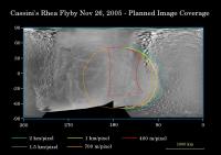
http://ciclops.org/view.php?id=1599 Regions that will be imaged by Cassini during the spacecraft's very close flyby of the moon Rhea...
-------------------- The scientist does not study nature because it is useful; he studies it because he delights in it, and he delights in it because it is beautiful.
Jules H. Poincare My "Astrophotos" gallery on flickr... |
|
|
|
|
|
|
Nov 18 2005, 10:55 PM
Post
#15
|
|
|
Member Group: Members Posts: 220 Joined: 13-October 05 Member No.: 528 |
400 Meters Per Pixel..... be still my beating heart.
 OK, OK.... we know that they don't put in the highest res picture footprints on these diagrams. Still..... one of the only things about Cassini that I find disappointing is the pointing problems they have due to the scan platform being removed and the resulting need to turn the spacecraft all the time to share the wealth with the various instruments. Sheesh... we got more high res pics of Europa on a Galileo flyby than we seem to get from the Enceladus flyby on Cassini. But the more I think of it... that may not be "one of the only things" I find disappointing about Cassini... it might be the only thing. I'll stop griping now. |
|
|
|
|

|
Lo-Fi Version | Time is now: 23rd April 2024 - 09:31 PM |
|
RULES AND GUIDELINES Please read the Forum Rules and Guidelines before posting. IMAGE COPYRIGHT |
OPINIONS AND MODERATION Opinions expressed on UnmannedSpaceflight.com are those of the individual posters and do not necessarily reflect the opinions of UnmannedSpaceflight.com or The Planetary Society. The all-volunteer UnmannedSpaceflight.com moderation team is wholly independent of The Planetary Society. The Planetary Society has no influence over decisions made by the UnmannedSpaceflight.com moderators. |
SUPPORT THE FORUM Unmannedspaceflight.com is funded by the Planetary Society. Please consider supporting our work and many other projects by donating to the Society or becoming a member. |
|