Printable Version of Topic
Click here to view this topic in its original format
Unmanned Spaceflight.com _ Phoenix _ Sol 22 and after
Posted by: Phil Stooke Jun 17 2008, 03:07 PM
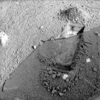
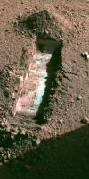
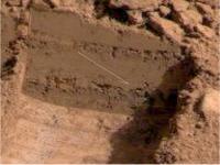
Here's a Sol 22 image of the new trenching area at the extreme right edge of the work area. I brightened the shadow to show the whole trench.
Phil
|
Posted by: MahFL Jun 17 2008, 03:35 PM
Nice, I was just looking at the pictures.
I noticed they dumped a scoop full at the far end of the trench rather than somewhere else, any one have any thoughts on why ?
Posted by: Tman Jun 17 2008, 05:08 PM
Further shots on this (additional the RGB)
http://www.greuti.ch/phoenix/of_SS022EFF_12CA8_RABC.jpg
http://www.greuti.ch/phoenix/of_SS022EFF898161657_12CAEL1M1.jpg
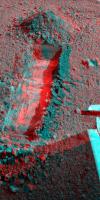
Posted by: ugordan Jun 17 2008, 06:08 PM
My color version of the new trench. Merged two red filter images that each seemed to show less compression artifacts in sunlit/shadow portions of the image, respectively.
http://i108.photobucket.com/albums/n15/ugordan/sol22_trench_2.jpg
Posted by: centsworth_II Jun 17 2008, 06:10 PM
No sign of the white stuff at the same depth as on the edge of the polygon. Interesting.
Maybe one more centimeter down?
Posted by: Pando Jun 17 2008, 07:01 PM
To me, it looks like the tool has scraped across a flat hard surface...
Posted by: imipak Jun 17 2008, 07:55 PM
Interesting large cracks in the surface to the right of the trench; it looks like a thick surface crust breaking up into large chunks as the scoop passes nearby. Anyone know if there's telemetry from the arm indicating how much effort was needed at different points of the scoop manoeuvre? And it does appear to be the more deeply shadowed area where this happens. Fascinating stuff!
Posted by: Stu Jun 17 2008, 10:18 PM
Quick look...
|
Posted by: Astro0 Jun 17 2008, 11:30 PM
If you haven't seen it yet, check out the raw images http://www.met.tamu.edu/mars/directory.html from Mark Lemmon.
Next to the Sol links, they've included a little description for the day's activities.
Some of it makes very amusing reading.
Well done Mark!
Sol 000 Land
Sol 001 Start looking around
Sol 002 Runout
Sol 003 Look around more, unstow RA
Sol 004 Finish unstow RA
Sol 005 Document Queen of Hearts
Sol 006 Image RA touch, TEGA prep, workspace
Sol 007 Dig! (well, test sample)
Sol 008 Document TEGA, OM prep; image workspace
Sol 009 Document sample site
Sol 010 Runout
Sol 011 Sample for TEGA
Sol 012 Bury TEGA
Sol 013 Find missing spring to go with found spring
Sol 014 Get ready to bury MECA
Sol 015 Sprinkle gently on MECA
Sol 016 MRO/PHX coordinated observations
Sol 017 Deliver to MECA
Sol 018 Strip mine Dodo
Sol 019 More digging, dislodge interesting fragment
Sol 020 Continue dodo trenching, wantonly destroy fragment
Sol 021 Atmosphere sol
Sol 022 Open up Wonderland for exploration
Posted by: fredk Jun 18 2008, 04:16 AM

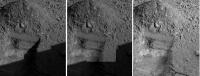
This appears to be the best-defined trench yet, probably because they haven't hit the substrate yet. But the trench floor is clearly heterogeneous, with well-defined regions that are either a lighter shade or a darker shade of the ubiquitous Martian hue. Obvious speculations include grain size or compositional differences between the two types of soil. I wonder if the scoop would be agile enough to sample the lighter and darker regions separately...
Posted by: centsworth_II Jun 18 2008, 06:39 AM
Hard to tell if the smooth sections are a hard material scraped smooth or a soft material smoothed flat.
But it looks pretty clear that there is no white material...yet.
Posted by: n1ckdrake Jun 18 2008, 07:55 AM
Updated in post #76
Posted by: Skyrunner Jun 18 2008, 09:19 AM
I haven't got the telemetry, but it's there. Every 200msecs during operation the arm reports telemetry of which only a part is:
- Motor current
- Motor voltage
- Joint angles
And so the amount of joint work, and thus joint torque, can be worked out for any part of the digging operation. Actually, telemetry is returned because according to the RA team it is "... most useful for scientific analysis during digging and soil-mechanic experiments. The motor currents, along with the reconstructed arm trajectories will yield information regarding the degree of difficulty of digging in the various soils encountered..."
This data will be archived in the PDS.
Posted by: Tomek Jun 18 2008, 09:40 AM
Greetings
On this picture I can see the first layer which probably is green or denitely have a diferent colour .
The same was posible to see in the first digging area but it is my opinion that the first layer is green and is wery thin .
In the Meca images was also seen some green sand particles .
Posted by: ugordan Jun 18 2008, 10:21 AM
I'm not convinced that's actually green. We'll have to wait for calibrated images, but my guess now would be it's an artifact of the raw images and that it's actually more grayish in color than the rest of the soil.
Posted by: Tomek Jun 18 2008, 11:10 AM
yes agree that it looks grayish now to .
Posted by: ugordan Jun 18 2008, 04:24 PM
Mark's SSI team produced a http://phoenix.lpl.arizona.edu/images/gallery/lg_6035.jpg of the new trench where they seamlessly removed the lander shadow. If I didn't know where the shadow edge was exactly, the image could have fooled me as being completely in sunlight. There's just a subtle hint of diffuse sky illumination in the shadowed area, reminiscent of soviet Venera surface shots.
Posted by: Airbag Jun 18 2008, 04:56 PM
Interesting; the floor of the trench is quite is flat yet the rubble piles have many "rocks" of various sizes in them. So either those are not rocks but clumps of material, or the "rocks" are only in the very upper layer?
Airbag
Posted by: jekbradbury Jun 18 2008, 05:06 PM
Here is a 8Mb zip of every color image produced by Phoenix to date, absolutely uncalibrated and untouched, with filenames simply a concatenation of the three constituent files' names:
http://jekbradbury.googlepages.com/color.zip
Posted by: robspace54 Jun 18 2008, 07:02 PM
On this picture I can see the first layer which probably is green or denitely have a diferent colour .
( picture removed, not really necessary )
The same was possible to see in the first digging area but it is my opinion that the first layer is green and is wery thin .
In the Meca images was also seen some green sand particles .
Didn't they identify olivine in the material sprinkeld onto the microscope? And the material can appear green (see
http://en.wikipedia.org/wiki/Olivine).
Posted by: slinted Jun 18 2008, 07:14 PM
Here's http://schwehr.org/blog/archives/2008-06.html#e2008-06-17T10_47_15.txt describing how it was made. Ah, the magic of Photoshop.
Posted by: Bill Harris Jun 18 2008, 07:30 PM
The lander's shadow was likely removed by using a Selection Tool to selsct the shadowed area and selectively bumping the shadowed area to match the sunlit area.
Ah, the magic of PShop, indeed.
--Bill
|
Posted by: imipak Jun 18 2008, 08:25 PM
Thanks! I wonder if the effort of breaking through the surface crust will show up in that data, and if (as it superfically appears to my uneducated eye) there's different structure in Wonderland than Dodo.
Posted by: tedstryk Jun 19 2008, 01:12 PM
Please forgive me for asking an ignorant question...I haven't been tracking things closely. How far is the Peter Pan from being complete?
Posted by: jamescanvin Jun 19 2008, 01:42 PM
There is just a 3x2 section to complete the horizon pan, the actual horizon bit (3x1) was taken on sol 22 but I believe lost due to the anomaly. Four pointings of the near field were also taken and downlinked on sol 21. I suspect we'll get most of the remaining data with the 'most-data-rich-sol-ever' going on tosol as a result of the anomaly.
James
Posted by: Phil Stooke Jun 19 2008, 03:49 PM
Can you dig it? Sol 24 trench widening.
Phil
|
Posted by: jekbradbury Jun 19 2008, 04:49 PM
My best attempt at color using the L1 and L2 filter images of Wonderland tosol- there's an area that is extremely reflective in the blue channel but not in the red, I have no idea what it could be:
|
Posted by: fredk Jun 19 2008, 04:51 PM
No obvious thread for this, but http://space.newscientist.com/article/dn14167-how-to-make-a-martian-mud-pie.html describing the various Martian soil simulants being tried.
Posted by: algorimancer Jun 19 2008, 04:58 PM
Blue ice? Hmmm... perhaps someone was here before us.

Posted by: fredk Jun 19 2008, 05:09 PM
Remember it can be very hard to get hues right with these stretched jpegs - the regular soil is so dark in blue filters that a white patch can seem overwhelmingly bright in blue filters. Still, there's definitely a hue difference from left to right across that original trench. Perhaps we're getting very close to the substrate.
If you look at Phil's posted image, we've already obliterated that blue-channel bright part of the first trench! No doubt we'll find more as we continue...
Posted by: ElkGroveDan Jun 19 2008, 05:16 PM
Looks like a nice chunk of white stuff has been excavated into the lower pile of debris.
Posted by: ugordan Jun 19 2008, 05:17 PM
Color shot of the work area and scoop:
http://i108.photobucket.com/albums/n15/ugordan/sol24_dig.jpg
There definitely is some differently colored soil down there. At least more gray than the rest, possibly bluish-greenish after all.
Dan, I think you've mistaken a part of sunlit soil in Phil's image as white stuff.
Posted by: Stu Jun 19 2008, 05:35 PM
Loving this new trench...!
|
Q: just wondering... was this 'scratch' caused by the rasp?
|
Posted by: ElkGroveDan Jun 19 2008, 06:21 PM
Agreed.
Posted by: fredk Jun 19 2008, 07:22 PM
Perhaps you were on to something - from http://www.met.tamu.edu/mars/directory.html
Posted by: jekbradbury Jun 19 2008, 10:48 PM
I spent over an hour attempting to fill in the 3 gaps in the stereo image released this morning, only to have Phoenix downlink a better version soon after. Anyway, here is the exercise in futility:
|
Posted by: jekbradbury Jun 19 2008, 11:57 PM
I wonder why a greater percentage of images than usual are suffering from data loss in transit. Is this a Phoenix, Odyssey, MRO, or DSN problem?
Posted by: tedstryk Jun 20 2008, 04:01 AM
James
Awesome!
Posted by: andrea Jun 20 2008, 07:20 AM
It's probably the link between Phoenix and Odyssey. While there is a automatic re-transmission protocol (Go-back N per CCSDS Proximity standards), there was a implementation "feature" (error) where in some rare occassions some packets are dropped. Same happens between the MERs and Odyssey, since the UHF radio is the same. Drop-out can also happen between Orbiter and Earth if the signal-to-noise ratio drops below threshold (too much rain, wind, mispoint, eats all the margin) but this happens much less frequently.
Posted by: Del Palmer Jun 20 2008, 01:05 PM
Due to the Flash anomaly, they've added extra UHF passes. Perhaps some of these extra passes are less than optimal (low elevation etc.).
Posted by: Tomek Jun 20 2008, 09:12 PM
New pictures from sol 25 

http://phoenix.lpl.arizona.edu/images/gallery/lg_7009.jpg
Posted by: Phil Stooke Jun 21 2008, 01:48 AM
I've made a sol-by-sol comparison of the Dodo-Goldilocks area showing surface activities. Some of the images are fudged a bit, but it gives the idea.
Phil
|
Posted by: jamescanvin Jun 21 2008, 09:19 AM
Agreed, moved posts to http://www.unmannedspaceflight.com/index.php?showtopic=5255
Posted by: jekbradbury Jun 21 2008, 02:17 PM
Using Phil's side-by-side comparison, here is the first and only definitive sol 5-20 über-animation (of doom).
Posted by: Phil Stooke Jun 21 2008, 06:29 PM
Nice!
Phil
Posted by: Tomek Jun 21 2008, 09:05 PM
It is posible that the olivine is in this layer to .
|
Posted by: jmjawors Jun 21 2008, 09:09 PM
I didn't hear that they *confirmed* olivine, just that some of the particles *looked like* and therefore very well could be olivine.
Posted by: ugordan Jun 21 2008, 10:31 PM
Sol 26 look:
http://i108.photobucket.com/albums/n15/ugordan/sol26_merged.jpg
Merged subframe at full color with full frame at 1/4 res color and single red full res frame. Lander shadow moved quite a bit causing discontinuities.
Posted by: fredk Jun 22 2008, 02:54 AM
Sol 25 Wonderland trench under late afternoon (almost 6pm) light.
|
Posted by: Phil Stooke Jun 22 2008, 04:02 AM
Mods - move this if you want it somewhere else...
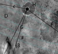
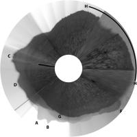
I took my circular version of the panorama, posted earlier, and laid it over Tim Parker's map at the best estimate location.
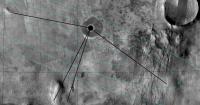
|
Then I used sight lines to hills to see which features we see on the horizon. The common features are labelled below.
|
|
Posted by: Phil Stooke Jun 22 2008, 04:10 AM
That puts the site about here, to put it in context.
Phil
|
Posted by: Stu Jun 22 2008, 09:45 AM
Sol 26 Wonderland trench... lots of detail visible...
|
Posted by: Paolo Jun 22 2008, 10:11 AM
amazing!
Posted by: jabe Jun 22 2008, 12:17 PM
Can't wait for them to start digging deeper. Any ideas on how deep they would like to go?
The layering in the trench should be interesting if they are able to dig deep.
I hope everyone is receiving http://twitter.com/marsphoenix from the lander. Soon to be ranked 7th on the http://www.twitterholic.com/ page. Number 4 seems doable
JB
Posted by: CosmicRocker Jun 23 2008, 05:31 AM
 They surely would want to dig as deeply as possible, as that would likely provide the longest line of geological/climatalogical history at this location. But then we would want to study that vertical section in context, requiring additional lateral excavations.
 I get the impression that the concern here is about a shallow ice table that might prevent digging deeply, thus the earlier suggestion that Phoenix might need to strip mine the national parks, to at least expose the topography of this local ice table. I suspect deeply-digging might be easier near the polygon boundaries, but I am not sure how those boundaries align with the digging degrees of freedom of the robotic arm. I can't wait to see what Phoenix does next...
Posted by: jmjawors Jun 23 2008, 06:11 AM
Ok, this brings up a question I've had for a while now which I may as well ask at the risk of sounding like an ignoramus.  Do we know how deep this ice layer should be? Do we have MEX or MRO data from their radars about this? I know there were press releases from MRO (I think) that showed an image produced by SHARAD of the north polar region, but it didn't really elaborate on what we were seeing.
Anyone have any more insight into this?
Posted by: peter59 Jun 23 2008, 06:24 AM
Sol 027: Exit safe mode ???
Posted by: ugordan Jun 23 2008, 07:30 AM
Yes, what's with no images received on sol 27?
Posted by: MahFL Jun 23 2008, 10:08 AM
Lemmons caption says they went into Safemode....
Sol 027: Exit safe mode (was: WCL test, remote sensing, hold sample for WCL)
Posted by: ugordan Jun 23 2008, 10:14 AM
I somehow missed that bit. It seems that after a near-perfect landing at a perfect location they've been having quite a bit of trouble ever so often, regardless be it with orbital or ground assets. Hope it's just a pesky cosmic ray hit this time.
Posted by: Stu Jun 23 2008, 04:53 PM
http://phoenix.lpl.arizona.edu/images.php?gID=0&cID=92 images are going up...
Posted by: fredk Jun 23 2008, 05:45 PM
The main ice exposure at the far end of Dodo/Goldilocks is continuing to darken:
http://www.met.tamu.edu/mars/i/SS028EFF898688905_132F0L1M1.jpg
It's easy to predict that the entire exposure will be dark in not too many sols. I'm intrigued by the fact that the darkened ice surface is actually darker than the surrounding soil, as I've mentioned before. I wonder how Holy Cow is doing.
This rapid darkening helps illustrate why we see no naturally exposed ice patches around (indeed, perhaps we should be looking for unusually dark, rather than light, areas!). Perhaps it also explains why we saw nothing bright in the heatshield crater (although that may have involved dark debris from the heatshield itself).
Posted by: Gray Jun 23 2008, 06:02 PM
That's a neat observation - that the lighter toned, presumably icy, patches become darker over time. This is, perhaps, due to the sublimation of an ice/soil mixture which leaves a soil residuum when the ice sublimates. But, what causes the darker tone, and should we expect the darker area to become lighter-toned with time? That is will the darker toned areas eventually attain a tone which is similar to the surrounding soil?
Posted by: scalbers Jun 23 2008, 06:02 PM
Just a reminder that if the color becomes darker than the surrounding soil, one possibility might be a wetting effect due to brief melting in the sunlight? Perhaps there are other possible mechanisms as well as Gray mentions.
Also we apparently see some very isolated naturally exposed ice patches in some orbiter images of the general landing zone, as mentioned in another thread.
http://www.unmannedspaceflight.com/index.php?s=&showtopic=557&view=findpost&p=118986
Steve
Posted by: ugordan Jun 23 2008, 06:19 PM
Is this an expected amount of dust accumulation on the magnets after 28 sols?
I seem to remember the rovers' calibration targets staying cleaner than this, but I might be mistaken.
Posted by: DDAVIS Jun 23 2008, 06:27 PM
Many of the Phoenix color image sequences are captured over enough time to cause the shadows to change between RGB exposures and thus appear noticably misaligned. Is this because the RGB components can't be made in a rapid sequence? The edges of rocks and shadows will suffer from color fringing across otherwise excellent color panoramas unless attantion is paid to this. Similar products from other recent surface cameras seem to have little of this problem.
Posted by: Stu Jun 23 2008, 08:36 PM
Interesting rocks here...
|
Posted by: peter59 Jun 23 2008, 09:24 PM
Sol 28 - Peter Pan finished (Az: 90 - 130)
|
Posted by: ugordan Jun 23 2008, 09:31 PM
This issue is present in MER imagery as well. Given automatic exposure adjustment, filter changing time, frame compression times with slow (by modern PC standards) flight computers, a couple of minutes can easily pass between consecutive frames. This is enough to make long shadows move over 3 exposures.
Posted by: ZenDraken Jun 24 2008, 12:56 AM
http://phoenix.lpl.arizona.edu/images/gallery/lg_7297.jpg
Now what would cause that? Moisture? Static cling seems unlikely.
Posted by: Juramike Jun 24 2008, 12:59 AM
Now what would cause that? Moisture? Static cling seems unlikely.
I'd go with electrostatics.
Posted by: James Sorenson Jun 24 2008, 01:34 AM
Now what would cause that? Moisture? Static cling seems unlikely.
The soil is not "hanging" from the scoop. The blade is just bleeded out by sunlight.
Posted by: fredk Jun 24 2008, 03:08 AM
That soil is neither hanging off the edge of the scoop, nor are we seeing ccd bleeding. In this image we can see that the true bottom edge of the scoop is below the apparent bottom in that original image:
http://phoenix.lpl.arizona.edu/images/gallery/lg_7298.jpg
Also see this image:
http://planetary.s3.amazonaws.com/data/phoenix/raw/RS026EFF898514145_131D0MBM1.jpg
Posted by: Juramike Jun 24 2008, 03:23 AM
Ahhhh! Thanks for illuminating that!
(I pull back my electrostatic comment)
Posted by: ZenDraken Jun 24 2008, 05:19 AM
http://phoenix.lpl.arizona.edu/images/gallery/lg_7298.jpg
Also see this image:
http://planetary.s3.amazonaws.com/data/phoenix/raw/RS026EFF898514145_131D0MBM1.jpg
Thanks, I feel slightly less stupid now!
Posted by: n1ckdrake Jun 24 2008, 05:40 AM
Updated Peter Pan
|
|
Posted by: Bill Harris Jun 24 2008, 11:55 AM
http://planetary.s3.amazonaws.com/data/phoenix/raw/RS026EFF898514145_131D0MBM1.jpg
What is thi site? I tried to get down to the root directory at "http://planetary.s3.amazonaws.com/" and got a "forbidden" error window. I've not heard of this site.
--Bill
Posted by: ugordan Jun 24 2008, 12:03 PM
That's Planetary Society's server. The image was nicked from Emily's blog.
Posted by: jamescanvin Jun 24 2008, 12:15 PM
Well not exactly nicked. 
It is where the full images are hosted for http://www.planetary.org/data/phoenix/raw/
Posted by: ugordan Jun 24 2008, 12:22 PM
Oh, I didn't mean nicked in a negative way. Yes, it's not off her blog directly, but her raw page. Mea culpa!
Posted by: fredk Jun 24 2008, 03:51 PM
High-reolution view of the heatshield impact (near the upper left):
http://www.met.tamu.edu/mars/i/SS028EFF898711228_11E1EL1M1.jpg
Has it collapsed completely?
Posted by: djellison Jun 24 2008, 06:41 PM
It's probably just behind local topography, like the 'chute.
Doug
Posted by: fredk Jun 24 2008, 07:41 PM
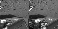
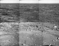
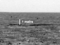
I estimate the heatshield is about 150 metres away, from the hirise images. The top of Oppy's heatshield was at roughly 1 metre above the ground. At 150 metres, a 1 metre tall object would span nearly 30 pixels in a full frame SSI image:
|
So either the heatshield has flattened dramatically, or there is some pretty dramatic topography out there (metre-scale, rather than the roughly 10cm scale we have nearby, I believe), or some combination of both of course. On the other hand, it wouldn't be surprizing if the heatshield slid/rolled into a local low point/trough after impact.
Just as a reminder, here's an image of Oppy's heatshield from a comparable distance:
http://marsrovers.jpl.nasa.gov/gallery/all/1/p/322/1P156772717EFF4000P2356L7M1.JPG
Of course, that was on the almost-atomically-flat tarmac!
Posted by: BrianL Jun 25 2008, 12:07 AM
Obviously, some homeless Martian has made off with it for a shelter. I mean, what other explanation is there?
Brian
Posted by: jbytów Jun 25 2008, 01:16 AM
.
Posted by: SickNick Jun 25 2008, 01:58 AM
Brian
Well, you could get imaginative and suggest that the hot heatshield melted down into the ice like the "China Syndrome" and that it's currently conducting an independent exploration of the secret subterranean seas of Barsoom

Posted by: marswiggle Jun 25 2008, 03:54 AM
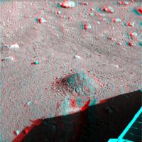
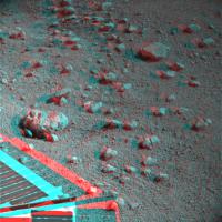
There's a noticeable ridge/height (in relative terms) in the landscape about at the distance of the heatshield, and well before the backshell, judging from these 3-d (x-eyed) crops. Look particularly the backshell, a metre-scale drop of the ground seems quite plausible.
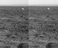
|
|
Posted by: Astro0 Jun 25 2008, 07:13 AM
Shhh. I know where it's gone!
It's fallen into.......wait for it............an "abyss" ! 

Sorry, couldn't help it!
Astro0
Posted by: Stu Jun 25 2008, 07:53 AM
If you look at the foreground in this 3D image I posted a while ago, I think it's pretty clear there are some serious dips and drops around Phoenix...
|
... and I'm still intrigued by that bright "patch" in the foreground, which no-one commented on when I pointed it out the first time...
Edit: if you find that pic a bit dark, try http://img.photobucket.com/albums/v509/cumbriansky/june-9-patch2s.jpg one...
Posted by: djellison Jun 25 2008, 09:41 AM
...did something really unusual and belly-flopped it's way to making a little inside-out structure. That didn't happen for Spirit, which just broke into a few pieces and sat flat on the ground. The heatshields are not 1m tall.
Doug
Posted by: MahFL Jun 25 2008, 10:26 AM
The surface is definitely not as flat as everyone seems to think it would have been, which is nice really.....
Also I forgot how flat Miridiani is !! flat flat flat.........
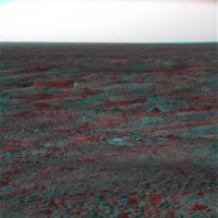
Posted by: fredk Jun 25 2008, 03:41 PM
They are interesting, but I'd be more intrigued if the light patches had a different hue from the rest of the soil, and the hues look similar to me...
Posted by: ugordan Jun 25 2008, 03:54 PM
Sol 29 color:
http://i108.photobucket.com/albums/n15/ugordan/sol29_color_2.jpg
From what I can tell, there is zero change in the righmost trench with that grayish stuff.
Posted by: imipak Jun 25 2008, 07:27 PM
*cough* Not quite http://www.unmannedspaceflight.com/index.php?showtopic=557&view=findpost&p=114465... I wouldn't mention it if it weren't so rare for me to be right about something
Edit - both Stu's anaglyphs and the official SSI animation of the workspace show lots of vertical relief on the 10s of cm scale.
Posted by: dvandorn Jun 26 2008, 07:59 PM
So... when are we going to start seeing some *deep* trenching?
I'd think that we'd need to first remove the upper regolith from a reasonably large patch and then start working on digging directly into the ice substrate. If we ever want to get ice samples into TEGA and WCL, we'll need to be working directly in the ice layer, I would think.
So far, I've not seen anything deeper than down to the very top of the ice layer -- we hit it and then we go off to the side. I grant you, it may not be easy to dig through the ice layer, but from the looks of things (and someone correct me if I'm wrong), it doesn't look like we have yet even tried.
-the other Doug
Posted by: elakdawalla Jun 26 2008, 08:07 PM
This question's been asked in press briefings. There's no intention to dig deeply into ice -- the deep digging discussed in the mission planning was to get to the ice, not into it. Digging now will be to expose the ice table, examine its contours, see what happens as it goes toward the polygon boundaries. They'll rasp into it to get samples but my understanding is that they don't plan to try to get deeply into its interior -- if I understand correctly, they won't get more than a few millimeters into it.
--Emily
Posted by: ngunn Jun 26 2008, 09:38 PM
They seem to be confident of being able to get some ice into the most accessible TEGA ovens - the end ones - before it sublimes away. That's an admirable goal but I think achieving it may not be at all straightforward. I say go for it and good luck!
What about the chances of delivering ice to the other instruments - any thoughts?
Posted by: jmjawors Jun 26 2008, 09:42 PM
TEGA is really the main instrument for ice. Ice in the WCL, for instance, wouldn't tell them much at all since it's just adding water to water. They'd definitely have to work fast to catch some in the microscope, but it'd be worth a try IMO.
Posted by: ahecht Jun 26 2008, 09:48 PM
Apparently the RAC has a macro mode:
Posted by: djellison Jun 26 2008, 10:04 PM
That's sort of the point of it - adjustable focus to fully image the contents of the scoop.
Doug
Posted by: 1101001 Jun 26 2008, 11:53 PM
What is this nicely machined part, the cylinder lower right, imaged about a dozen times on Sol 30?
http://phoenix.lpl.arizona.edu/images.php?gID=7674&cID=98 http://phoenix.lpl.arizona.edu/images.php?gID=7620&cID=98
Just noticed there must be at least two of them pictured, for they were taken by the SSI, azimuth 305 and 167.
Posted by: Airbag Jun 27 2008, 12:04 AM
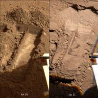
A sol 29/31 comparison (using ugordan's sol 29 image shown above as a reference)
|
Possible light layer seen in the far "wall"; the dark layers may be some shadow effects (low Sun angle) from a couple of rough ledges. Also some more shallow excavations and/or and impression of the scoop - see the "vertical" lines pattern. The "normal" pattern appears to be the "washboard road" horizontal ridges produced by the scoop "chattering" (?) over the harder underlying surface (or maybe showing the resolution of the steps in scoop's control?).
No more white layers, and some new dark splodges that seem to bear no obvious relationship to either the light or dark ones from sol 29, but maybe associated with the sol 29 white layer?
Airbag
Posted by: James Sorenson Jun 27 2008, 03:02 AM
This is only speculation right now, but since in wonderland we dont see the bright material that we see in the dodo-goldilocks trench and the arm struck a solid surface in the wonderland trench, could we be seeing a higher ratio of soil to ice in wonderland?. Could that explain those dark sploches?.
Posted by: hortonheardawho Jun 27 2008, 05:45 AM
sol 8 - 31 comparison of lander leg:
http://farm4.static.flickr.com/3115/2615353026_485d3cdbb9_o.gif
Yikes!
Full frame comparison http://www.flickr.com/photos/hortonheardawho/2615353016/.
Posted by: James Sorenson Jun 27 2008, 06:17 AM
WOW! that is interesting indeed . Any possibility's that the legs were covered by dust on landing, and wind is slowly blowing it off?. looks like ice to me.
Posted by: ugordan Jun 27 2008, 06:47 AM
Looks like a play of the shadows to me.
Posted by: Shaka Jun 27 2008, 06:55 AM
What exactly are we seeing here?
I see a brighter illumination in sol 30, but, beyond that, I am totally underwhelmed by the changes.
I would have expected much more. What substantive changes can be seen? 
Where is "ice" disappearing?
Posted by: dilo Jun 27 2008, 06:57 AM
Hi 105, should be part of LIDAR station (look to official CG video, is very clear that laser beam exit from it!)
Posted by: Tman Jun 27 2008, 07:08 AM
Looking at this leg after 31 sols it crosses my mind "what adhesive was used here"?
Posted by: djellison Jun 27 2008, 07:32 AM
There are three of them - they are where the uprights of the landing legs came thru the lander deck before they were deployed.
The LIDAR laser has been imaged, but that's not what those images are of. The LIDAR laser is much smaller, closer.
Doug
Posted by: Stu Jun 27 2008, 07:43 AM
I love low-Sun-angle shots like http://img.photobucket.com/albums/v509/cumbriansky/trench-low-sun-s.jpg, don't you..?
P.S. This week's "http://www.slackerastronomy.org/wordpress/index.php/archive/carnival-of-space-no-60/" is being held at 'Slacker Astronomy'. Some Phoenix-related posts on there.
Posted by: ilbasso Jun 27 2008, 12:56 PM
Perhaps this leg was not manufactured according to the agreed specifications.
Posted by: ngunn Jun 27 2008, 01:16 PM
Soddit, our college has blocked access to that site. You can brief me on any special goodies this evening.
Posted by: nprev Jun 27 2008, 06:52 PM
Wow, Horton, thanks for that blink comparison!
Weird indeed. My impression is that there's some post-landing gunk on the strut, and it's encouraging frost formation on the spots. The illumination angles don't look too different. IIRC, the atmospheric temperature gradient is horribly steep on the downward slope once you go up from the surface; maybe it's just enough to make a difference, assuming the soil spots aren't very good conductors of heat.
Alternatively, could the descent engine exhaust have caused chemical 'burns' on the strut with slightly different thermal properties? Sounds unlikely, but I'm just throwing out ideas here.
Posted by: elakdawalla Jun 27 2008, 07:00 PM
I'm surprised no one has yet commented on the fact that they're now filling in gaps in the Peter Pan and maybe going on to a new panorama. The new name? "RePeter Pan." GROOOAAANNN!
And I haven't a clue what's going on with that landing leg. I think you can say that there's no drastic change to the exposed ice surface at Holy Cow. But I'm flummoxed as to why the landing leg should look spottier now than it did before. I'm disinclined to believe it has anything to do with windblown anything because there's been no obvious wind-induced changes in the dig sites. So I guess frost might be more plausible, I suppose it's always dark and cold under there. But I'm unconvinced.
--Emily
Posted by: ugordan Jun 27 2008, 07:02 PM
I took me a second to figure this out, hahahaha. They're hilarious!
Posted by: hortonheardawho Jun 27 2008, 09:20 PM
http://www.flickr.com/photos/hortonheardawho/2615187881/ is the sol 8-31 animation under the lander with exposures for sunlight.
I expect UA / JPL / NASA to show their properly calibrated RAD version "soon" demonstrating changes to the surface of the ice in direct sunlight.
Posted by: slinted Jun 27 2008, 11:03 PM
Here's a comparison showing the activity in the Wonderland site on sol 32. There is a wide area of newly exposed 'dark stuff' from the sol 32 scraping.
http://www.lyle.org/~markoff/collections/SS031EFF898974659_138F8RC.jpg
http://www.lyle.org/~markoff/collections/SS031EFF898974659_138F8RC.jpg
http://www.lyle.org/~markoff/collections/SS032EFF899062107_13AB8RC.jpg
http://www.lyle.org/~markoff/collections/SS032EFF899062107_13AB8RC.jpg
Sorry there's no animated gif, the limited color pallet couldn't handle the variations from the moving mast shadows.
Posted by: ugordan Jun 27 2008, 11:38 PM
Nice color renditions, slinted!
My version based on cylindrical map projected products:
http://www.fileden.com/files/2007/9/14/1431389/sol-31-32.gif
Posted by: Stu Jun 27 2008, 11:38 PM
http://img.photobucket.com/albums/v509/cumbriansky/deep-s.jpg... they're really stepping up digging operations...
Posted by: Paul Fjeld Jun 28 2008, 01:07 AM
Pretty sure that's wrong too: the gear were stored through three http://www.met.tamu.edu/mars/i/SS006EFF896738245_1110CL1M1.jpg in the Science Deck.
My guess is that they are the hard points that attached to the aeroshell (maybe with spring "pushers" to get a positive separation?). Note the two little caps standing up with springs behind it - I'm guessing that's where the electrical/telemetry umbilicals would have come out.
Paul
Edit - fixed my goofball link, added 1101001's original quote
Posted by: nprev Jun 28 2008, 02:22 AM
This is why I'm inclined to believe that some soil splatter stuck to the strut, and these in turn may be acting as nuclei for frost formation. Crap sticking to struts happens all the time on aircraft landing gears, even in arid environments, although one big reason for this is that they are lubricated with hydraulic fluid. The basic post-flight inspection checklist includes wiping down landing gear struts for all aircraft I've dealt with. Anybody know if a lubricant was used for Phoenix's struts?
Posted by: dvandorn Jun 28 2008, 04:32 AM
At the risk of resembling the 600-lb gorilla in the room, by what mechanism do we see water ice sublimating away out of the shadowed bottoms of trenches and yet putatively accreting onto the landing leg structure? If the temperature and pressure are such that the water ice will sublime in the shadow of a trench, I would think that just being shadowed under the lander wouldn't change the conditions enough to not only prevent sublimation, but encourage deposition.
I'm more inclined to think that the two images are basically identical, the later one with a far different lighting angle that highlights every little lump and bump of dirt blown onto the structure during the landing.
-the other Doug
Posted by: fredk Jun 28 2008, 04:45 AM
If I've got my geometry right, the landing leg with frosty(?) spots should be in shade pretty much all day, while the vanishing ice chunks in the trench would have been in direct sun for much of the mornings (and closer to the ground, so warmer for that reason too). Those chunks probably went through cycles of sublimation and redeposition at evening/night, until sublimation won and they were gone for good. Maybe deposition is winning on the shaded legs.
Posted by: Shaka Jun 28 2008, 06:05 AM
-the other Doug
Agreed. Those who don't need to show some careful measurements of what has changed.
Posted by: Stu Jun 28 2008, 06:52 AM
I'm fascinated by the different rocks visible around the lander, and this mix caught my eye... lots of smooth, featureless rocks of roughly the same size, with some much more rugged-looking, weathered rocks laying amongst them... I know these rocks are pretty common around the lander, but this little scene just caught my eye...

|
Any geologists want to explain the differences? I'm guessing the smooth rocks are local, because there are so many of them, and the other rocks are ejecta from elsewhere..?
Posted by: Bill Harris Jun 28 2008, 12:20 PM
-the other Doug
Have you seen the Horton amimations of the underside?
http://www.flickr.com/photos/hortonheardawho/2615187881/in/photostream/
http://www.flickr.com/photos/hortonheardawho/2615353016/in/photostream/
http://www.flickr.com/photos/hortonheardawho/2615353026/in/photostream/
What alternative explanations would you suppose? P'haps a gleyed soil? <g>
--Bill
Posted by: Bill Harris Jun 28 2008, 12:25 PM
<snip>
I know that there is absolutively no relation here, but these dark areas are very reminescent of mottles in a hydric soil.
--Bill
Posted by: Doc Jun 28 2008, 12:58 PM
If you look at the sol 31 image carefully, you'll notice that the leg nearest to the RAC is beginning to suffer the 'frosty mould' syndrome.
The leg is also shaded but why doesn't it have as much frost as the other shaded leg. Is it because it is not well shade as the other or is it something else?
Posted by: ugordan Jun 28 2008, 01:12 PM
Everybody seems to take this is frost as an established fact. Isn't it a little too hot for that yet, the temperatures don't drop below some -80 deg C at night and CO2 frost needs -130 deg C IIRC?
Posted by: fredk Jun 28 2008, 01:43 PM
Err... I'd been thinking H20 frost, not CO2...
Looking at Hortons closeup flicker gif of the spotty leg, there are spots towards the lower left end of the leg that appear darker than the leg in the sol 8 view but lighter than the leg in the sol 31 view. It's very hard to imagine different lighting explaining that. H20 frost nucleating in the shade on spots of soil kicked up during landing sounds reasonable.
Posted by: fredk Jun 28 2008, 01:47 PM
From http://phoenix.lpl.arizona.edu/06_27_pr.php
Have they actually used the rasp? I'd have expected it to leave an obvious mark.
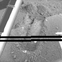
Posted by: centsworth_II Jun 28 2008, 02:16 PM
Looks to me like, rather than the rasp, the flat section within the larger trench was possibly made with the secondary blade of the scoop.

|
Posted by: fredk Jun 28 2008, 02:29 PM
You may be right about the secondary blade. But to answer my own question, could these be rasp marks?

|
(Cropped from slinted's sol 32 colour composite.)
Posted by: jamescanvin Jun 28 2008, 03:08 PM
I don't think so, those marks are at the end of each line of trenching. It may have been caused by the rasp as the scoop rotated at the end of the trench but a doubt it was intentional rasping.
I think that is just a unfortunate choice of word relating to the scraping. Rasping would not 'flatten the layer' as the sentence reads, the scraping would.
Posted by: Airbag Jun 28 2008, 03:21 PM
|
|
I think the unusual markings shown in the Sol 31 image referenced in http://www.unmannedspaceflight.com/index.php?s=&showtopic=5249&view=findpost&p=119357 may be caused by the secondary blade; that also explains why the soil appears to be raised as compared to Sol 29 closer to the lander as the action of the secondary blade would push some soil ahead of it instead of scooping it up out of the way like the main blade would.
Airbag
Posted by: Tman Jun 28 2008, 03:36 PM
It may be goofy (since it didn't come up until now), couldn't that single contamination of one leg be caused from the released hydrazin after landing? The freezing point of hydrazin is about the same as water. Is that valve close to the leg?
Edit: I see!
Posted by: ugordan Jun 28 2008, 03:59 PM
Hydrazine wasn't vented after landing, only helium used for pressurization was.
Posted by: Airbag Jun 28 2008, 06:59 PM
A http://www.met.tamu.edu/mars/032.html late afternoon mini-pano (from half-res images) looking towards the eastern solar panel; the http://www.met.tamu.edu/mars/index.html shadow is present again.

|
Airbag
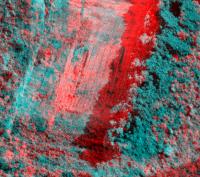
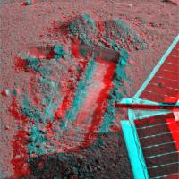
Posted by: edstrick Jun 29 2008, 08:50 AM
Did a quickie experiment with a pretty new pic pair of an old trench.
One version's the regular red/green/blue composite, the yellower version's infrared/red/green.
The scraped and powderey looking ice is darker, but still blue at the shifted wavelengths.
Water ice is more strongly absorbing in the near IR (photo IR) than at red wavelengths. The result is pretty much as expected.

|

|
Posted by: ugordan Jun 29 2008, 07:02 PM
Sol 33 color with fudged data gaps:
http://i108.photobucket.com/albums/n15/ugordan/sol33_color.jpg http://i108.photobucket.com/albums/n15/ugordan/sol33_color_2.jpg
Posted by: slinted Jun 29 2008, 08:06 PM
Thanks for cleaning up the gaps ugordon (what a mess!), your images looks flawless.
Posted by: Bill Harris Jun 30 2008, 12:11 AM
>(what a mess!)
Would they be planning to re-transmit later, or are these images "WYSIWYG"?
--Bill
Posted by: Deimos Jun 30 2008, 05:49 PM
Would they be planning to re-transmit later, or are these images "WYSIWYG"?
Commands to resend the missing packets are routinely generated. However, with the normal flash limitations, lower priority "sent" data rarely still exists when the commands get there. Sometimes the stripes are filled in with an ODY retransmit request; other times "bested" DSN data arrives later with fewer missing packets. Generally, they should be filled in within a day or two if they can ever get filled in.
Posted by: ugordan Jun 30 2008, 05:53 PM
So was this a Phoenix -> ODY dropout or ODY -> DSN?
Posted by: ugordan Jul 1 2008, 02:54 PM
Finally some more vanity shots of the deck and various thingamabobs, can't wait until someone mosaics this...
http://i108.photobucket.com/albums/n15/ugordan/sol35_vanity.jpg
Posted by: Airbag Jul 1 2008, 03:45 PM
Same here! They are all part of the full Peter Pan I guess. Huh, in that lower left image some of those parts look like the air filter and fuel line of my lawn mower...

Airbag
Posted by: ugordan Jul 1 2008, 04:30 PM
Heh... there are actually automatically generated mosaics already, although they seem to clip the brightest pixels to zero and give weird effects. Color cylindrical projection http://www.fileden.com/files/2007/9/14/1431389/sol35_auto.jpg (75% full res, 900 KB). Yes, this is most likely part of the (Re)Peter Pan and probably would be more fitting in that thread.
Posted by: jamescanvin Jul 1 2008, 04:36 PM
Technically this is known as the Deck Pan and has a different ID from Peter Pan. It also doesn't have the full resolution R1 like Peter just the ABC downsampled.
I'll certainly be trying to get it into the Peter Pan of course.
Posted by: ugordan Jul 1 2008, 04:41 PM
So in contrast it actually has a proper red channel?
I can understand why they used RA on the deck, the R1 gives funny colors for the blue cal target as it verges into the infrared quite a bit. I do find it a bit peculiar that the downsampled frames are less sharp than their full-res counterparts (and I'm talking about more distant objects as well).
Posted by: Airbag Jul 1 2008, 05:07 PM
It is a shame (for us) that R6 (DiopterBlue) is not a clear filter. If it were so, then one could take much sharper close-ups of the deck and use those as the "value" component and the less sharp color images for the "hue and saturation" components to get very good overall color images.
However, that is not a mission success criteria I would guess and no doubt the team already has plenty of very sharp images (taken with other cameras) of the deck taken here on Earth!
Airbag
Posted by: Oersted Jul 1 2008, 10:02 PM
Space.com-article:
http://www.space.com/missionlaunches/080701-phoenix-update.html
"[...] It then used the rasp on the scoop at the end of the arm to make 50 scrapes in the ice and then heaped the scrapings into little piles each with about two to four teaspoonfuls of ice. The scraping created a grid in the icy layer about 0.08 inches (2 millimeters) deep.
On Sunday, mission scientists used the craft's Surface Stereo Imager to view the scrapings and agreed that they were ideal representatives of the boundary between dirt and ice."
Posted by: jmjawors Jul 1 2008, 10:07 PM
Hrm. My impression from the http://www.jpl.nasa.gov/news/phoenix/release.php?ArticleID=1771 today was that they scraped with the blade, not rasped. Not sure if Space.com misunderstood or if I misread it.
Besides, doesn't the rasp kick the ice flakes right into the scoop and not into piles on the ground?
Posted by: Bill Harris Jul 1 2008, 10:53 PM
From todsay's update at the Phoenix website: http://phoenix.lpl.arizona.edu/07_01_pr.php :
No mention of the rasp. The Space.com article was a bit, uh, spacey.
--Bill
Posted by: Stu Jul 2 2008, 05:41 AM
Interesting detail visible in the trenches now...

|
Posted by: centsworth_II Jul 2 2008, 06:34 AM
I still don't see any obvious white patches of ice like those in Goldilocks.
Posted by: jmknapp Jul 2 2008, 11:44 AM
Dodo-Goldilocks from Sol 36, simple composite of RGB channels: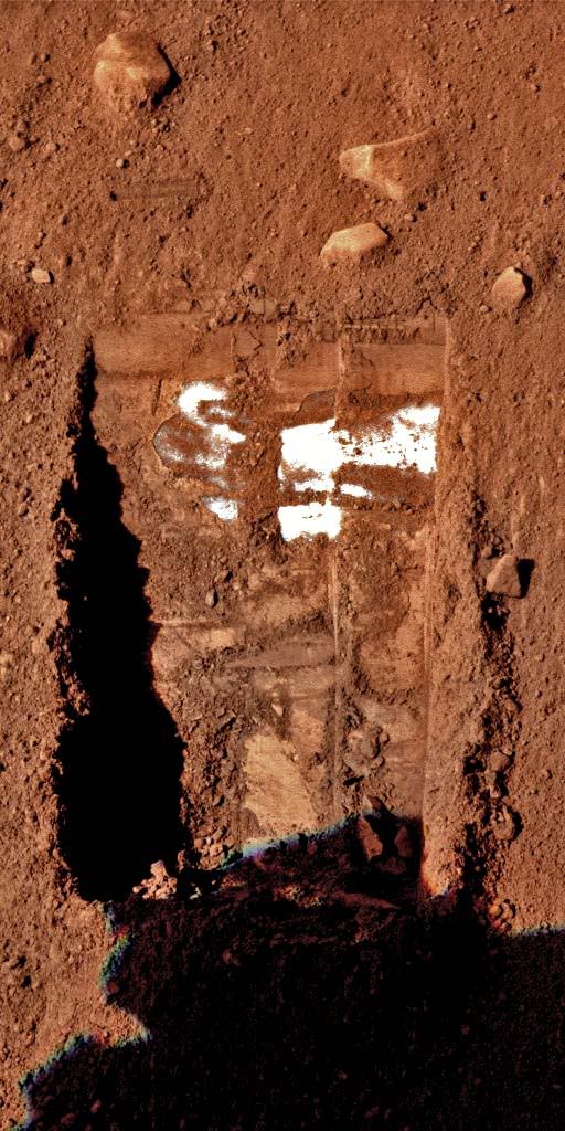
Could anyone tell me how to get these images to appear in the reduced/click-to-enlarge view?
Posted by: Tesheiner Jul 2 2008, 12:00 PM
> Could anyone tell me how to get these images to appear in the reduced/click-to-enlarge view?
There might be other ways but the one I know is by posting the picture as an attachment instead of including it as an image.
Posted by: hortonheardawho Jul 2 2008, 06:35 PM
sol 34-36 R1abc pan of Wonderland:
http://www.flickr.com/photos/hortonheardawho/2631751782/
The R1 images were registered and colored with the 1/2 size RA, RB, RC images of the same area.
This will have to do until full resolution, full filter sequences are done.
Posted by: elakdawalla Jul 2 2008, 06:42 PM
Oh, that's very nice, horton!
--Emily
Posted by: teck Jul 3 2008, 01:38 PM
What is this worm like feature?
Form Sol 37

|
Posted by: PDP8E Jul 3 2008, 01:42 PM
I see no worms, just shadows
(check the time of sol for each image in the sequence and you will see that the sun moves from phoenix' perspective)
cheers
Posted by: Stu Jul 3 2008, 02:07 PM
Something caught my eye in a new 3D image I've just made... down at the bottom there... look like eroded "plates" of material of some kind..?

|
Posted by: chris Jul 3 2008, 02:10 PM
Stu,
You beat me to it. I was about to mention that.
Chris
Posted by: Bill Harris Jul 3 2008, 02:30 PM
Any CLUE as to what raw images these are? "plates2b.jpg" doesn't tell us diddly.
--Bill
Posted by: Stu Jul 3 2008, 02:36 PM
Sorry, should have explained...
"plates2b"
"plates" = I thought they looked like plates of material, so I called the image "plates"
"2" = it was my second version of the 3D image; the first was ruined when I cropped it.
"b" = a smaller size version of the original, so it didn't chew up too much space on UMSF...
Simple really.
But if you want to be all technical about it, here you go...
http://www.met.tamu.edu/mars/i/SS037ESF899496095_1420EL2M1.jpg
http://www.met.tamu.edu/mars/i/SS037ESF899496149_1420ER2M1.jpg

Posted by: nprev Jul 3 2008, 02:56 PM
Hmm...evaporite crusts? Maybe there's a chunk of ice just below that spot that gets warm enough to sublimate on occasion.
Posted by: Bill Harris Jul 3 2008, 04:46 PM
Thanks.
--Bill
Posted by: Stu Jul 3 2008, 05:45 PM
Hmmm... looking at a 3D made from a different pair of images, taken earlier in the mission, those "plates" look more like cracks in a crusty layer to me... interesting...

|
I'll track down the actual raw images so that anyone who wants to take a look for themselves can do; haven't got them to hand 'cos these were just stored on my computer to make a 3D pic with, sorry.
Edit: here you go... found 'em...
http://www.met.tamu.edu/mars/i/SS025EFF898450342_1305EL1M1.jpg
http://www.met.tamu.edu/mars/i/SS025EFF898450342_1305ER1M1.jpg
Posted by: Stu Jul 3 2008, 06:55 PM
http://img.photobucket.com/albums/v509/cumbriansky/holey-chunk-s.jpg that a few of you might enjoy wandering around... have to admit I'm fascinated by that big hole-ridden chunk on the left there...
Posted by: Bill Harris Jul 3 2008, 08:02 PM
Any CLUE as to what raw images these are? A "holey-chunka" doesn't tell us diddly about the source image...
--Bill
Posted by: Stu Jul 3 2008, 08:14 PM
What's wrong with "holey chunka"? If the Phoenix team can call their features after fairy tale characters I think "holey chunka" is pretty good!
Here you go Bill...
http://www.met.tamu.edu/mars/i/SS036EFF899421974_11E1EL1M1.jpg
http://www.met.tamu.edu/mars/i/SS036EFF899421974_11E1ER1M1.jpg
Don't say I never give you anything
P.S. "http://img.photobucket.com/albums/v509/cumbriansky/holey-chunkacopy.jpg"... like it
Posted by: Stu Jul 4 2008, 09:46 PM
"Midgard" in 3D... lots and lots of holes...

|
Posted by: Aussie Jul 4 2008, 11:56 PM
Hortonheardawho did an extremely clear x-eye on this rock Stu. Hope he does not object to my linking.
http://www.flickr.com/photos/hortonheardawho/2637145756/in/photostream/
Do we have any idea what type of rock this is? It does look similar to wind erosion I have observed on sandstone.
Posted by: Stu Jul 5 2008, 12:11 AM
I think this rock, "Midgard" (apparrently, in Norse myth, Midgard was the defensive fortress which the gods build about the middle portion of the earth allotted to men in order to protect mankind from the giants) is one of my favourites seen on Mars so far...
http://img.photobucket.com/albums/v509/cumbriansky/midgard-col-sol38-c.jpg
Posted by: nprev Jul 5 2008, 12:22 AM
If I had to guess, I'd say Midgard is igneous; a leftover from magma with a lot of gas in solution. There are many similar rocks around V2. IIRC, the northernmost volcanic construct thus far identified on Mars is at or above 60 deg north latitude.
Posted by: SickNick Jul 5 2008, 07:40 AM
Form Sol 37
|
|
I think what you're seeing is a string of pebbles along the joins between polygons. It tends to "snake" across the ground a bit, but is, of course, static on our timescale. A lot of strings of pebbles, and other dry, dusty "channels" exist in this patterned ground...
Posted by: Ant103 Jul 5 2008, 10:09 AM
A view of the pad, a solar pannel and ground near it on Sol 38 :
http://www.db-prods.net/blog/wp-content/uploads/2008/07/sol38-piedpanneau-moasaic.jpg
Posted by: Ant103 Jul 5 2008, 02:19 PM
Two another pictures
The deck on Sol 39 :
http://www.db-prods.net/blog/wp-content/uploads/2008/07/panodeck-sol39.jpg
And a cobble field :
http://www.db-prods.net/blog/wp-content/uploads/2008/07/ss039eff899686408_143d0lcoul.jpg
Anaglyph :
http://www.db-prods.net/blog/wp-content/uploads/2008/07/ss039eff899686408_143d0-anaglyph-color.jpg
Posted by: nprev Jul 5 2008, 03:44 PM
Beautiful as always, Ant, thank you!
There sure seem to be a lot of rocks with vesicles mixed in with other types whose pedigree seems less clear. Probably the entire geological history of Mars is to be found here, but it's been thoroughly mixed up by frost upheaval.
Just for fun, let's look for pieces of ancient seabed...
Posted by: hortonheardawho Jul 5 2008, 06:50 PM
July 4, 2008 on the planet Mars:
http://www.flickr.com/photos/hortonheardawho/2639927336/
THought I would turn this into a postcard as a tribute to the Independence day of many who were responsible for this endeavor.
Posted by: Shaka Jul 5 2008, 08:46 PM
Not because they are easy, but because they are hard.

Posted by: CosmicRocker Jul 6 2008, 05:19 AM
Bravo, hortonheardawho! That was excellent. But if it were my lab bench, I'd be reaching for a broom to tidy the area up.
Shaka: I hope I found an accurate transcription of that historic speech. I think it might be worth replaying, as it contains some noteworthy thoughts...
Delivered in person by John F. Kennedy, Houston, Texas
September 12, 1962
President Pitzer, Mr. Vice President, Governor, Congressman Thomas, Senator Wiley, and Congressman Miller, Mr. Webb, Mr. Bell, scientists, distinguished guests, and ladies and gentlemen:
I appreciate your president having made me an honorary visiting professor, and I will assure you that my first lecture will be very brief.
I am delighted to be here and I'm particularly delighted to be here on this occasion.
We meet at a college noted for knowledge, in a city noted for progress, in a State noted for strength, and we stand in need of all three, for we meet in an hour of change and challenge, in a decade of hope and fear, in an age of both knowledge and ignorance. The greater our knowledge increases, the greater our ignorance unfolds.
Despite the striking fact that most of the scientists that the world has ever known are alive and working today, despite the fact that this Nation¹s own scientific manpower is doubling every 12 years in a rate of growth more than three times that of our population as a whole, despite that, the vast stretches of the unknown and the unanswered and the unfinished still far outstrip our collective comprehension.
No man can fully grasp how far and how fast we have come, but condense, if you will, the 50,000years of man¹s recorded history in a time span of but a half-century. Stated in these terms, we know very little about the first 40 years, except at the end of them advanced man had learned to use the skins of animals to cover them. Then about 10 years ago, under this standard, man emerged from his caves to construct other kinds of shelter. Only five years ago man learned to write and use a cart with wheels. Christianity began less than two years ago. The printing press came this year,and then less than two months ago, during this whole 50-year span of human history, the steam engine provided a new source of power.
Newton explored the meaning of gravity. Last month electric lights and telephones and automobile sand airplanes became available. Only last week did we develop penicillin and television and nuclear power, and now if America¹s new spacecraft succeeds in reaching Venus, we will have literally reached the stars before midnight tonight.
This is a breathtaking pace, and such a pace cannot help but create new ills as it dispels old, new ignorance, new problems, new dangers. Surely the opening vistas of space promise high costs and hardships, as well as high reward.
So it is not surprising that some would have us stay where we are a little longer to rest, to wait. But this city of Houston, this State of Texas, this country of the United States was not built by those who waited and rested and wished to look behind them. This country was conquered by those who moved forward--and so will space.
William Bradford, speaking in 1630 of the founding of the Plymouth Bay Colony, said that all great and honorable actions are accompanied with great difficulties, and both must be enterprised and overcome with answerable courage.
If this capsule history of our progress teaches us anything, it is that man, in his quest for knowledge and progress, is determined and cannot be deterred. The exploration of space will go ahead,whether we join in it or not, and it is one of the great adventures of all time, and no nation which expects to be the leader of other nations can expect to stay behind in the race for space.
Those who came before us made certain that this country rode the first waves of the industrial revolutions, the first waves of modern invention, and the first wave of nuclear power, and this generation does not intend to founder in the backwash of the coming age of space. We mean to be a part of it--we mean to lead it. For the eyes of the world now look into space, to the moon and to the planets beyond, and we have vowed that we shall not see it governed by a hostile flag of conquest, but by a banner of freedom and peace. We have vowed that we shall not see space filled with weapons of mass destruction, but with instruments of knowledge and understanding.
Yet the vows of this Nation can only be fulfilled if we in this Nation are first, and, therefore, we intend to be first. In short, our leadership in science and in industry, our hopes for peace and security, our obligations to ourselves as well as others, all require us to make this effort, to solve these mysteries, to solve them for the good of all men, and to become the world's leading space-faring nation.
We set sail on this new sea because there is new knowledge to be gained, and new rights to be won, and they must be won and used for the progress of all people. For space science, like nuclear science and all technology, has no conscience of its own. Whether it will become a force for good or ill depends on man, and only if the United States occupies a position of pre-eminence can we help decide whether this new ocean will be a sea of peace or a new terrifying theater of war. I do not say the we should or will go unprotected against the hostile misuse of space any more than we go unprotected against the hostile use of land or sea, but I do say that space can be explored and mastered without feeding the fires of war, without repeating the mistakes that man has made in extending his writ around this globe of ours.
There is no strife, no prejudice, no national conflict in outer space as yet. Its hazards are hostile to us all. Its conquest deserves the best of all mankind, and its opportunity for peaceful cooperation many never come again. But why, some say, the moon? Why choose this as our goal? And they may well ask why climb the highest mountain? Why, 35 years ago, fly the Atlantic? Why does Rice play Texas?
We choose to go to the moon. We choose to go to the moon in this decade and do the other things, not because they are easy, but because they are hard, because that goal will serve to organize and measure the best of our energies and skills, because that challenge is one that we are willing to accept, one we are unwilling to postpone, and one which we intend to win, and the others, too.
It is for these reasons that I regard the decision last year to shift our efforts in space from low to high gear as among the most important decisions that will be made during my incumbency in the office of the Presidency.
In the last 24 hours we have seen facilities now being created for the greatest and most complex exploration in man's history. We have felt the ground shake and the air shattered by the testing of a Saturn C-1 booster rocket, many times as powerful as the Atlas which launched John Glenn, generating power equivalent to 10,000 automobiles with their accelerators on the floor. We have seen the site where the F-1 rocket engines, each one as powerful as all eight engines of the Saturn combined, will be clustered together to make the advanced Saturn missile, assembled in a new building to be built at Cape Canaveral as tall as a 48 story structure, as wide as a city block, and as long as two lengths of this field.
Within these last 19 months at least 45 satellites have circled the earth. Some 40 of them were "made in the United States of America" and they were far more sophisticated and supplied far more knowledge to the people of the world than those of the Soviet Union.
The Mariner spacecraft now on its way to Venus is the most intricate instrument in the history of space science. The accuracy of that shot is comparable to firing a missile from Cape Canaveral and dropping it in this stadium between the the 40-yard lines.
Transit satellites are helping our ships at sea to steer a safer course. Tiros satellites have given us unprecedented warnings of hurricanes and storms, and will do the same for forest fires and icebergs.
We have had our failures, but so have others, even if they do not admit them. And they may be less public.
To be sure, we are behind, and will be behind for some time in manned flight. But we do not intend to stay behind, and in this decade, we shall make up and move ahead.
The growth of our science and education will be enriched by new knowledge of our universe and environment, by new techniques of learning and mapping and observation, by new tools and computers for industry, medicine, the home as well as the school. Technical institutions, such as Rice, will reap the harvest of these gains.
And finally, the space effort itself, while still in its infancy, has already created a great number of new companies, and tens of thousands of new jobs. Space and related industries are generating new demands in investment and skilled personnel, and this city and this State, and this region, will share greatly in this growth. What was once the furthest outpost on the old frontier of the West will be the furthest outpost on the new frontier of science and space. Houston, your City of Houston, with its Manned Spacecraft Center, will become the heart of a large scientific and engineering community. During the next 5 years the National Aeronautics and Space Administration expects to double the number of scientists and engineers in this area, to increase its outlays for salaries and expenses to $60 million a year; to invest some $200 million in plant and laboratory facilities; and to direct or contract for new space efforts over $1 billion from this Center in this City.
To be sure, all this costs us all a good deal of money. This year¹s space budget is three times what it was in January 1961, and it is greater than the space budget of the previous eight years combined. That budget now stands at $5,400 million a year--a staggering sum, though somewhat less than we pay for cigarettes and cigars every year. Space expenditures will soon rise some more,from 40 cents per person per week to more than 50 cents a week for every man, woman and child in the United Stated, for we have given this program a high national priority--even though I realize that this is in some measure an act of faith and vision, for we do not now know what benefits await us. But if I were to say, my fellow citizens, that we shall send to the moon, 240,000 miles away from the control station in Houston, a giant rocket more than 300 feet tall, the length of this football field,made of new metal alloys, some of which have not yet been invented, capable of standing heat and stresses several times more than have ever been experienced, fitted together with a precision better than the finest watch, carrying all the equipment needed for propulsion, guidance, control,communications, food and survival, on an untried mission, to an unknown celestial body, and then return it safely to earth, re-entering the atmosphere at speeds of over 25,000 miles per hour,causing heat about half that of the temperature of the sun--almost as hot as it is here today--and do all this, and do it right, and do it first before this decade is out--then we must be bold.
I'm the one who is doing all the work, so we just want you to stay cool for a minute. [laughter]
However, I think we're going to do it, and I think that we must pay what needs to be paid. I don't think we ought to waste any money, but I think we ought to do the job. And this will be done in the decade of the sixties. It may be done while some of you are still here at school at this college and university. It will be done during the term of office of some of the people who sit here on this platform. But it will be done. And it will be done before the end of this decade.
I am delighted that this university is playing a part in putting a man on the moon as part of a great national effort of the United States of America.
Many years ago the great British explorer George Mallory, who was to die on Mount Everest, was asked why did he want to climb it. He said, "Because it is there."
Well, space is there, and we're going to climb it, and the moon and the planets are there, and new hopes for knowledge and peace are there. And, therefore, as we set sail we ask God's blessing on the most hazardous and dangerous and greatest adventure on which man has ever embarked.
Thank you.
Posted by: bcory Jul 6 2008, 06:55 AM
http://www.youtube.com/watch?v=FYb_mhiE-qU
Posted by: bcory Jul 6 2008, 07:02 AM
Shaka: I hope I found an accurate transcription of that historic speech. I think it might be worth replaying, as it contains some noteworthy thoughts...
http://www.youtube.com/watch?v=aTyYM-dUgCI&feature=related
http://www.youtube.com/watch?v=mfhIjI_N1Pk&feature=related
Posted by: AndyG Jul 6 2008, 12:26 PM
Interesting too, to note that the NASA budget is still less than that spent domestically on tobacco and cigarettes. http://en.wikipedia.org/wiki/NASA_budget contains more than a few facts to sway those who continue to believe that space science is not cost-effective...as Doug has pointed out before, all those dollars are spent on Earth.
Andy
Posted by: Ant103 Jul 6 2008, 05:55 PM
Hi
Littles pictures made recently
http://www.db-prods.net/blog/wp-content/uploads/2008/07/pandeck-hires-sol39.jpg
A field of cobbles :
http://www.db-prods.net/blog/wp-content/uploads/2008/07/ss040eff899762807_144b0lcoul.jpg
And the Dodo&Goldilocks trench :
http://www.db-prods.net/blog/wp-content/uploads/2008/07/ss040esf899761709_14490rcoul.jpg
Posted by: Oersted Jul 6 2008, 10:11 PM
http://www.youtube.com/watch?v=mfhIjI_N1Pk&feature=related
thanks bcory for posting the links to the video of the full speech!
Never knew that Kennedy made a joke just before his famous line about "going to the Moon because it is hard". See for yourself in the very last minute of the video in the first link above...
Posted by: Stu Jul 6 2008, 10:18 PM
Wouldn't you just love to reach down and pluck this little guy off the ground and take a closer look..?

|
Posted by: Shaka Jul 6 2008, 11:34 PM
I'd like to hold him down and RAT his rind off first!
Posted by: glennwsmith Jul 7 2008, 02:07 AM
We may raise some eyebrows with all of this Kennedy stuff, but the fact is that the the project of "sending a man to the moon and returning him safely to the earth before the end of the decade" [sorry about the sexism] was really one of the two or three cultural pillars of the 60's. Humans are never so happy as when they have a shared goal, and Kennedy understood that. Perhaps a good project for all of us geniuses at UMSF would be to articulate a new goal for space exploration -- and it could be unmanned/robotic -- that would be as compelilng as Kennedy's vision in 1961. I realize that this is precisely what the best minds at NASA/JPL/etc. have been agonizing over for these many months and years -- but hey, we're good! And it is more than interesting that UMSF brings an international perspective to the question.
Posted by: jekbradbury Jul 7 2008, 02:16 AM
EDIT - deleted (my own) post that may have violated Guidelines
Posted by: bcory Jul 7 2008, 03:09 AM
Never knew that Kennedy made a joke just before his famous line about "going to the Moon because it is hard". See for yourself in the very last minute of the video in the first link above...
You're welcome.
Yes the Rice vs. Texas university football joke
I liked his double joke later on in part 2 about how hot it was that day at Rice Field
"re-entering the atmosphere at speeds of over 25,000 miles per hour,causing heat about half that of the temperature of the sun--almost as hot as it is here today--and do all this, and do it right, and do it first before this decade is out--then we must be bold.
I'm the one who is doing all the work, so we just want you to stay cool for a minute. [laughter]"
Posted by: Pavel Jul 7 2008, 06:02 AM
I'm not sure Earth can sustain us anymore
Posted by: Stu Jul 7 2008, 12:06 PM
Couple of views from the latest release...
"http://img.photobucket.com/albums/v509/cumbriansky/PuffandBigShip2.jpg" (Hey, I don't choose the names! )
http://img.photobucket.com/albums/v509/cumbriansky/meander2.jpg... (3D)
Posted by: SickNick Jul 7 2008, 01:09 PM
http://www.db-prods.net/blog/wp-content/uploads/2008/07/ss040eff899762807_144b0lcoul.jpg
Interesting to see that these aren't just random stones lying on the surface. They have a semi-regular spacing, a preferred orientation (approx at 90 degrees to the shot) and are more worn on the right hand side - these are Ventifacts - worn by aeons of wind action. With a bit of work, a geologist could begin to date the surface age from the amount of erosion, and a climatologist compare the modern and palaeo winds...
Australia has vast areas of what we call "Gibber Plain" or stony desert - a surface armour of pebbles protects the sand and dust from wind erosion. Here on Mars we have a similar aeolian process, plus a slow churning of the soil through polygon formation - be it freeze-thaw or just thermal expansion and contraction plus some vapour state diffusion and sublimation.
Mars is an interesting place...
Posted by: imipak Jul 7 2008, 07:08 PM
A friend (from the UK) who did a stint as a flying doctor in the said the colloquial name is "GAFA" -- Great Areas of not very much
Would that unidirectional wind be the seasonal wind blowing off the polar ice cap in (presumably) the spring?
A question that's been nagging away at me for weeks: is it possible that the slow churning of water and/or CO2 ice could "suck" rocks away from the underlying bedrock and transport them to the surface? (And do we have any idea how thick the ice layer is, anyway?) My uneducated guess would be not, as otherwise the surface layer of rocks and regolith would be much thicker; but then, we don't know the rates of erosion and transport away from this location, either. I've been trying to picture how these chunks of rock came to be lying just here. Presumably some will be impact and/or volcanic ejecta that happened to fall here, but surely not all of it. What about the rest? Dust and very small grains can blow or saltate here, but how did the large chunks become detached from the parent body and come to be lying on top of this layer of ice?
Ah, speculation... I can't help myself sometimes
Posted by: 1101001 Jul 7 2008, 07:43 PM
http://en.wikipedia.org/wiki/Patterned_ground
Adjust for local Mars conditions.
Posted by: vikingmars Jul 7 2008, 10:04 PM
Here is a mosaic showing the Phoenix workspace... It reminds me the Viking old times... Enjoy !

|
Posted by: Decepticon Jul 8 2008, 06:47 PM
Im confused!? Why has digging stoped?
Can't they go any deeper?
Posted by: jmjawors Jul 8 2008, 06:51 PM
They've hit the ice layer so they're not going to be able to get any deeper. No real reason to, besides.
Posted by: akuo Jul 8 2008, 06:58 PM
The top of the ice layer was scraped during the last sol:
http://phoenix.lpl.arizona.edu/images/gallery/lg_10878.jpg
Posted by: JRehling Jul 8 2008, 07:11 PM
Just a casual glance at the calendar. The primary mission's more than half over, and while the mission isn't sure to end on the last day, it's sure not to last TOO much longer, and could even end sooner with partial hardware failures (beyond those already seen).
Color me pessimistic, just a tad, but I'm starting to get the feeling I have when my sports teams are trailing and the time on the clock ticks down. Still plenty of time left for everything good to happen, but I'm not sure if the dark clouds are accumulating faster than the silver linings.
Some good science has been had, but we really need to get some results on the ice, and get the best possible search for organics on at least one sample of soil, but preferably definitely more than one sample in case the putative organics may be fleeing surface strata for lower down.
I know that a nice, crisp schedule of digging and dumping will carry the day, but the time to do this is a little less slack than it was on Sol #1.
Posted by: PDP8E Jul 8 2008, 08:13 PM
What is this and why does the Phoenix team image it every week or so with 10+ images each?
thanks in advance (...doug)

|
Posted by: djellison Jul 8 2008, 08:17 PM
I had to ask as well... it's a ceramic blank that they can call on to hack into with the arm rasp, and do a tega run on to establish an independent 'blank' for organics etc.
Doug
Posted by: PDP8E Jul 8 2008, 08:21 PM
Doug,
Thanks! You're the man!
Cheers
Posted by: jamescanvin Jul 8 2008, 08:41 PM
But that doesn't answer why they keep imaging it.
Monitoring dust deposition?
Posted by: djellison Jul 8 2008, 08:45 PM
I guess so - it's probably the only 'known ' surface of the lander that isn't covered in bloody magnets
Doug
Posted by: Reckless Jul 8 2008, 09:06 PM
http://phoenix.lpl.arizona.edu/images/gallery/lg_10878.jpg
That looks like a rasp (radula) mark in the front of this trench
Roy
Posted by: centsworth_II Jul 8 2008, 09:18 PM
Could be. If so, I wonder if it is an incidental mark made by a non-operating rasp, or if this represents the purposeful use of a functioning rasp.
Posted by: Aussie Jul 8 2008, 10:03 PM
Yeah, I'm with you. Potentially 6 operable ovens left, half the mission time gone and no apparent sense of urgency. Ahh well. The buck stops with them and I guess the the view is a bit distorted from my armchair.
Posted by: Juramike Jul 8 2008, 10:44 PM
I'm not too worried. With the next TEGA run perhaps the last, I'll guess that the team is trying to carefully plan a flurry of activity to deliver the most ice-rich sample possible to the oven. I'll bet when it happens, things will move very, very quickly.
(I expect a sudden switch to a carefully planned "Hurry-up offense" )
Posted by: jmjawors Jul 8 2008, 11:18 PM
I agree, Mike. If I feel any sort of letdown it's from the decreasing coverage and more infrequent briefings (which of course is just a product of how long it's been since landing now), but not the mission itself. Glass half full!
Speaking of "hurry-up offense," JPL has issued a new release:
[http://www.jpl.nasa.gov/news/news.cfm?release=2008-127]
Posted by: Aussie Jul 9 2008, 03:39 AM
I have to admit to some confusion. Some reports state clearly that the short circuit and it's effects are confined to the single oven. Others indicate that vibrating the mesh for the next sample may cause a short circuit terminating all capability. Anyone know the real story? What was the nature of the short and what is the failure mode/effects flowing from it?
Posted by: dvandorn Jul 9 2008, 06:09 AM
http://phoenix.lpl.arizona.edu/images/gallery/lg_10878.jpg
I quote this post to illustrate a rather important change in the Phoenix website.
Note the base URL above -- http://phoenix.lpl.arizona.edu.
Guess what? If you go to the home page based on that URL, you get redirected to:
http://phoenix-web.jpl.nasa.gov/
The University of Arizona seems to no longer be hosting their own Phoenix website!
And by the way -- this makes every single link we have in here to images at the original URL base broken.
-the other Doug
Posted by: alan Jul 9 2008, 06:28 AM
And by the way -- this makes every single link we have in here to images at the original URL base broken.
-the other Doug
Seems to be back up now.
Posted by: Stu Jul 9 2008, 07:48 AM
In 3D that http://img.photobucket.com/albums/v509/cumbriansky/SS043EFF900005586_14B04L1M1-3d-s.jpg is starting to look like a burial pit...!
Posted by: ugordan Jul 9 2008, 08:02 AM
Hope it's not a grave for TEGA they're digging!
*ducks and runs for cover*
Posted by: Stu Jul 9 2008, 08:15 AM
More likely a grave for the guy who "didn't build it to specifications"...
Posted by: ugordan Jul 9 2008, 09:20 AM
Quick color composites:
http://i108.photobucket.com/albums/n15/ugordan/sol42_prescrape.jpg http://i108.photobucket.com/albums/n15/ugordan/sol43_postscrape.jpg
Sol 42, pre-scrape on the left, sol 43 post-scrape on the right.
And a cropped and zoomed flicker gif between the two:
http://i108.photobucket.com/albums/n15/ugordan/sol42_43.gif
Posted by: jmknapp Jul 9 2008, 12:28 PM
Given that there appears to be a layer of ice under the regolith, as the kids say, how deep is the ice likely to be? Is it possible that it's a frozen ocean?
Posted by: centsworth_II Jul 9 2008, 02:09 PM
I read that analysis of the ice by Phoenix can tell if the ice is from a frozen ocean or water deposited from the atmosphere. I don't know how. As far as the depth is concerned, I wonder if MRO or Mars Express have been or will be of any help there. I don't recall seeing any info on that... but I mostly just read press releases and this forum.
Posted by: ngunn Jul 9 2008, 02:27 PM
There is a marvellous deep radar section of the polar ice from Mars Express. I'll try to find the link but somebody'll probably beat me to it. EDIT: that should of course say MRO.
Here it is:
http://www.nasa.gov/mission_pages/MRO/multimedia/sharad-20080515.html
Posted by: marsbug Jul 9 2008, 03:47 PM
Looks like the ice is http://www.space.com/missionlaunches/080709-phoenix-update.html than expected. Some great science has been done but I worry the second half of the mission might go a bit shakesperian....
Posted by: jmknapp Jul 9 2008, 03:52 PM
Did they have a press conference? Didn't see one listed on the web site... going on two weeks now. Rumors of an epidemic at Clavius?
Posted by: dvandorn Jul 9 2008, 04:12 PM
Not for me. Not even getting the redirect, now -- just your basic 404 error.
-the other Doug
Posted by: elakdawalla Jul 9 2008, 04:20 PM
No press conference seems to be in the offing this week. I just called and got ahttp://www.planetary.org/blog/article/00001542/. The first part of the press release makes it sound as though the digging is tougher than expected, but then it goes on to quote Ray as saying it's what they expected. I think it's more accurate to say that digging is tough, but not tougher than they expected. Perhaps tougher than they had hoped.
--Emily
Posted by: centsworth_II Jul 9 2008, 04:37 PM
http://www.nasa.gov/mission_pages/MRO/multimedia/sharad-20080515.html
I've seen the polar cap stuff, but nothing on the circumpolar, subsurface ice.
Posted by: jmknapp Jul 9 2008, 06:00 PM
Your blog is the best source of news of late!
PS caught your tutorial on how to get started in manipulating planetary raw images--excellent. Just the thing for the Planetary Society to be doing.
Posted by: ngunn Jul 9 2008, 08:57 PM
Well you most likely have seen this, but here is a version that does show a section on the left that lies outside the cap. Not much layering and no clear bottom to that unit to be sure. Is it the same as the base unit marked 'BU' underneath the presumed base of the cap? It doesn't look the same in character, but it seems to continue at the same level on the section. I wonder just how distinct is the boundary between polar cap ice and the ice both underneath and around it? Presumably the polar cap has moved around and shrunk and grown in rather drastic ways over geological timescales.
http://www.nasa.gov/images/content/227416main_phillips_fig1_rgb.tif
Posted by: Aussie Jul 10 2008, 01:56 AM
Kathryn Fishbaugh did some good work on the north polar cap. Pre MRO results but well worth the read.
http://www.lpi.usra.edu/meetings/sixthmars2003/pdf/3141.pdf
The MRO site sets an age for the North Polar ice cap (layering above the basal unit) of 4 million years based on layer counts. I would anticipate some significant margin of error on that method but the current cap is a recent phenomona. As I understand it the Maxwell time for Mars could be as high as 10 million years which makes me wonder about previous comments indicating that the lack of deflection in the sub-ice basement indicates an very thick, inelastic lithosphere (leaving aside any Tharsis bulge arguments). I am sure they have data on the expected ice thickness at the Phoenix site. I just can't find where it is presented.
Posted by: bcory Jul 10 2008, 03:45 AM
Some what related in finding water out there. It seems the Moon has had it for a long time:
New scans show evidence of water on the moon
" Tiny green and orange glass balls brought back from the moon nearly 40 years ago by astronauts show evidence that water existed there from the very beginning, scientists reported on Wednesday.
They used a new method of analyzing elements in the lunar sand samples to show strong evidence of water, dating back 3 billion years."
"Their study, published in the journal Nature, could support evidence that water persists in shadowed craters on the moon's surface -- and that the water could be native to the moon and not carried there by comets."
http://news.yahoo.com/s/nm/20080709/sc_nm/moon_water_dc_1
Posted by: jmjawors Jul 10 2008, 04:18 AM
Apples and oranges.
Water on the moon is certainly interesting. In fact, it's being discussed http://www.unmannedspaceflight.com/index.php?showtopic=5296&hl=.
Posted by: slinted Jul 10 2008, 02:32 PM
Here's two comparison blinks of Snow Queen, sol 21 - 44 taken from slightly different positions and angles. I didn't have much luck overlaying the two views on each other, hence the separate animations. Some of the changes are clearly real like the moving sand grains and some of the changes are lighting differences like upper left corner of 21 B (the sol 44 images were taken ~ 15 minutes earlier in the sol). The rest are less clear...cracks, trails of rolling particles, or shadows?:
http://www.lyle.org/~markoff/collections/rac21_44a.gif
http://www.lyle.org/~markoff/collections/rac21_44b.gif
Posted by: Ant103 Jul 10 2008, 06:29 PM
A color analgyph of the ground, deeper than it looks to be.
http://www.db-prods.net/blog/wp-content/uploads/2008/07/ss044eff900110851_14e10-anaglyph.jpg
And a view with a piece of solar pan, and the horizon (actualy, a small part of the Peter Pan)
http://www.db-prods.net/blog/wp-content/uploads/2008/07/solarpaneltohorizon-sol44.jpg
Posted by: bcory Jul 10 2008, 09:25 PM
Water on the moon is certainly interesting. In fact, it's being discussed http://www.unmannedspaceflight.com/index.php?showtopic=5296&hl=.
Don't know why you say Apples and oranges.
This may prove that water exisited in ALL our solar system bodies during the time of their formation and did not come from comets colliding with said bodies INCLUDING Mars..
Posted by: JRehling Jul 10 2008, 10:26 PM
To consider the missing link, in many ways, between Mars and the Moon, think about Phobos. It matches Mars's distance from the Sun exactly, and while lacking that thin but potentially crucial whisper of atmosphere that Mars has, it may maintain ice at depth better than the Moon. After seeing the MRO images of Phobos, I wondered if it doesn't deserve to be on the list of places where we could hunt for life. (And I'd have no reason not to include Deimos in the same breath.) Is 7 mb of CO2 really a crucial difference? I admit, having the simplest organic molecule be ubiquitous sounds like a nice boon to biology, but then, might Phobos have some slow outgassing of CO2 as well?
Posted by: jmjawors Jul 10 2008, 10:39 PM
bcory, I was not trying to be dismissive of your post, so I apologize if it sounded that way. I think the latest find is very interesting and worthy of a lot more study to try and determine exactly *how* this water got there. It has big implications for us (potentially) as we return to the moon. And yes, you're right, it might have implications for other bodies in our solar system as well and our level of understanding their formation.
It's just that the scale and scope of water's history on the moon and on Mars is vastly different. Hence the "apples and oranges" comment. On Mars we're talking about possible past oceans, ground water, flooding events, even transient water outbursts today. On the moon we're talking about... well, nobody is really sure what we're talking about yet.
And besides, this doesn't have to do with Phoenix, which is why I linked to the thread that's specifically about the topic you brought up.
Posted by: Juramike Jul 10 2008, 10:49 PM
I may be out on a limb here, but I think the bestest simplest organic molecule (for life anyway) might be methane (CH4).
CO2 is all oxidized up. You need to put big energy into the system to reduce it down to start building complex biomolecules.
CH4 is a better start point. You can go downhill to get "oxidized" and build up bigger useful stuff (For example: 2CH4 --> CH3CH3 + H2 is technically an oxidation of the carbon atom)
The other thing you would need would be a redox couple down deep. (I'm assuming surface photosynthesis wouldn't be the first option on Phobos.) So some type of reservoir of sulfur or phosphorous or some other handy electron reservoir that could be used as redox "food" to drive the biosynthetic reactions.
So yeah, having water for a solvent, an easy redox couple and a good source of carbon feedstock would be pretty good ingredients for life, in my opinion.
At this point, I wouldn't rule out any planetary body having deep life. [I'm still not so sure about Io, however.]
-Mike
Posted by: CosmicRocker Jul 11 2008, 06:28 AM
So, wouldn't we have expected to see more significant changes to that surface if this is truly ice? If the water ice sublimation rates for the Phoenix location that I've seen posted in this forum are even approximately correct, we should have noticed more significant changes to this outcrop between sol 21 and 44, if it was indeed composed of ice. It "looks" so much like the expected ice to me that I am not certain how to reconcile these time lapse images with my Martian expectations.
Posted by: Skyrunner Jul 11 2008, 07:53 AM
What do we know about 'contaminated' water ice sublimation in Martian conditions? Does much change due to salts or sand in the ice. The sublimation rate would surely be different if ice was more like icecrete (more sand than ice), would it?
Posted by: Aussie Jul 11 2008, 07:57 AM
Just how much solar energy is actually getting to the ice under the lander and in the trench? If my memory serves the sublimation of a cubic centimeter of ice takes 720 calories or just over 3 kilojoules. The regolith also seems to be a much better insulator than previous models would have us believe else there would not be ice so near the surface.
Posted by: Tman Jul 11 2008, 08:47 AM
There could be a lump that apparently disintegrated in Dan's GIF. Strange that it seems to be the only one and there without direct solar radiation, isn't it.

|
Posted by: SteveM Jul 11 2008, 01:45 PM
Steve M
Posted by: slinted Jul 11 2008, 02:41 PM
I made the exact same mistake when I looked at them (even to the point of doubting myself again later, and double checking that I hadn't switched the sol labels).
Posted by: Tman Jul 11 2008, 02:41 PM
Oops, you're right, did only look at the slightly brighter spot then where the lump appears and mixxed it up.
Btw. what's up with http://www.met.tamu.edu/mars/directory.html The site seems to be entirely offline.
Posted by: hortonheardawho Jul 11 2008, 03:18 PM
http://www.flickr.com/photos/hortonheardawho/2658014227/sizes/o/ is my take on the sol 21 to 44 changes to the ice under the lander.
The images were registered with a double affine registration ( effectively six point registration ) and then brightness matched, so I think you can believe any changes you see -- including shape changes to the ice mass. The sol 21 image was the one transformed, so it has a slight loss in sharpness.
Posted by: SickNick Jul 11 2008, 03:28 PM
Steve M
My suggestion would be that one of the blobs of "dirt" that were plastered over the lander legs (and, by implication, the lower deck) has fallen down to the ground.
I'm rather more interested in a different blob to right of centre that appears to have "moved"...
Posted by: fredk Jul 11 2008, 03:50 PM
You can see the mark made by the TECP on sol 43,
before: http://planetary.s3.amazonaws.com/data/phoenix/raw/RS043EFF900022824_14C60MDM1.jpg
after: http://planetary.s3.amazonaws.com/data/phoenix/raw/RS043EFF900024540_14C66MDM1.jpg
Posted by: Stu Jul 11 2008, 10:58 PM
Phew... catching up on things here after being AFUMSF for two days... combination of no internet connection thanks to the latest Windows-update-from-hell, and a visit to my mum's, whose PC was affected also... thanks SO much Mr Gates.... 
Anyway... seems like an interesting couple of days! Some nice scenic shots again... I heard another piece on the TV the other night (I think it was Chris Lintott on The Sky at Night) describing the landing site as "flat" and "featureless"... yet whenever I see a view like this the words "rolling" and "countryside" spring to mind...

|
Posted by: TheChemist Jul 12 2008, 12:28 AM
Is this journalist very young or what ?
Was not he around a couple of years ago, when the rest of the world witnessed the Meridiani definition of flat and featureless, during Oppy's travels south from Endurance to Victoria ?
[Stu, you 're young too. Your mum owns a PC ? ]
Posted by: Stu Jul 12 2008, 06:14 AM
]Owns, yes. Uses, no.
Posted by: peter59 Jul 12 2008, 06:29 AM
What's happen with Mark Lemmon's site ? 
http://www.met.tamu.edu/mars/directory.html
Posted by: Stu Jul 12 2008, 06:53 AM
I invite you all to take a look around Phoenix's very own "http://img.photobucket.com/albums/v509/cumbriansky/rocks-july12-3d.jpg"...
Posted by: slinted Jul 12 2008, 11:53 AM
TECP in action, on sol 46
http://www.lyle.org/~markoff/processed/SS046ESF900307364_15190R2.jpg
Posted by: vikingmars Jul 12 2008, 01:08 PM
http://www.met.tamu.edu/mars/directory.html
I was told they have a Web upgrade during this WE and it should return to normal a few days from now...
Posted by: peter59 Jul 12 2008, 01:29 PM
full inline quote removed - Admin
Vikingmars, are you on this photo ?

|
Photo taken after successful Viking 1 landing.
Posted by: centsworth_II Jul 12 2008, 07:01 PM
http://www.lyle.org/~markoff/processed/SS046ESF900307364_15190R2.jpg
Good view of the secondary blade and rasp too!
Posted by: ugordan Jul 12 2008, 07:06 PM
Nice colors there, slinted!
Posted by: Stu Jul 13 2008, 06:53 AM
Lots of detail visible in http://img.photobucket.com/albums/v509/cumbriansky/trench-jul13s.jpg new trench image...
(You found any 3D glasses yet Nick??)
Posted by: Ant103 Jul 13 2008, 01:18 PM
And what about with Tamu website? Can't found the page where raw are placed . It was helpfull before (the phoenix galery is awfull and nasa main page are not updated
).
Posted by: elakdawalla Jul 13 2008, 05:13 PM
Mark Lemmon knows about the problem with the SSI site and it is being worked on...
--Emily
Posted by: Stu Jul 14 2008, 10:48 AM
3D of new trench site... just have to http://img.photobucket.com/albums/v509/cumbriansky/scoop-sol48crop.jpgfirst...
Posted by: nprev Jul 14 2008, 11:19 AM
Yep; gonna go get 'em after work today!
Posted by: jmknapp Jul 14 2008, 12:19 PM
BTW, in the States, https://www.sciplus.com is a good place for quirky stuff like that. I just searched their website and see a https://www.sciplus.com/singleItem.cfm/terms/11631 (el cheapo) glasses for $2.75--although the minimum web order is $10. Not sure if those are up to the standard of UMSF though!
Posted by: Stu Jul 14 2008, 12:30 PM
I always advise people who want some 3D glasses - and who maybe can't access the internet - to go down their local magazine shop or discount book store and scan the racks and shelves for children's mags or books for 3D "specials" about dinosaurs, bugs or space. There's usually at least one magazine or book that comes with a free set of 3D glasses, and they're usually really cheap, too.
Alternately, go into a big confectionary store or department store ("Woolworths" is a safe bet here in the UK), find the "Pick n Mix" counter and scan the boxes for sweets wrapped in clear but coloured cellophane. There's bound to be some sweets wrapped in red or blue, and, at a pinch, their wrappers can be used to make a pair of make-do 3D glasses until you can lay your hands on a proper pair.
Also a very good excuse to pig out on sweets.
Posted by: Stu Jul 14 2008, 02:23 PM
Another http://img.photobucket.com/albums/v509/cumbriansky/jul14a2.jpg...
... with this interesting rock that caught my eye. There's a small concave area, with what looks like smaller pieces of rock inside it...

|
Phoenix's very own "Berry Bowl" eh? Curious as to how smaller pieces got in that depression though... weathering/erosion/wasting of the rock itself? Debris created by the impact by a small meteorite?
Fascinating place...
Posted by: vikingmars Jul 14 2008, 10:00 PM
Vikingmars, are you on this photo ?
No, but Steve Wall (without the helmet) is : I worked a with him designing the VL imaging catalog and for VL imaging data storage for the PDS at NSSDC...Posted by: Stu Jul 14 2008, 10:14 PM
Hey Nick - something to try out your new 3D glasses on...
http://img.photobucket.com/albums/v509/cumbriansky/h-sol49c.jpg
Posted by: Phil Stooke Jul 15 2008, 12:07 AM
I think that's Ken Jones with the helmet.
Phil
Posted by: edstrick Jul 15 2008, 11:11 AM
"I think that's Ken Jones with the helmet."
and I think the other vikinger is Steve Wall.
Posted by: slinted Jul 15 2008, 12:20 PM
Phoenix significantly extended the length of the Snow White trench on sol 49, and might have exposed some bright ice. It's a very small spot, but I don't think it's a lighting effect. It shows up in all filters, doesn't move, and is (relatively) brightest in green/blue like the ice seen in the Dodo trench.
This a crop and brightness enhancement of that particular spot, click through for the full frame.
http://www.lyle.org/~markoff/processed/SS049EFF900565996_15830RC.jpg
Posted by: elakdawalla Jul 15 2008, 02:15 PM
Well spotted, Dan.
By the way, it looks like Mark is back in business with the TAMU website; it's up-to-date to sol 49.
--Emily
Posted by: fredk Jul 15 2008, 04:55 PM
Snow White imaged just after 8:00 the morning of sol 47 showed a region that was much more prominent in the blue L2 filter than in red (L1):

|
Views later in the day show the brighter region, but its contrast with the surrounding soil has decreased dramatically. One guess is that in the morning we were seeing (near) specular reflection off a smooth surface. But that should also be prominent in the red filter. Also the geometry doesn't look favourable to specular reflection.
Could there be a thin layer of H20 frost that appeared during the colder "night"? I believe it was PI Smith who mentioned the possibility of frost growing on the exposed ice table due to a "cold finger"-like effect.
I'd sure like to get a handle on the various dynamics that are/may be going on here, and why (until now) Snow White didn't have any relatively very bright regions unlike Dodo/Goldilocks...
Posted by: climber Jul 15 2008, 09:14 PM
No, but Steve Wall (without the helmet) is : I worked a with him designing the VL imaging catalog and for VL imaging data storage for the PDS at NSSDC...Olivier, I love your B&W "à la Viking" rendition of Phoenix surrounding from a few days ago.
This give a different and very sharp perspective
Posted by: imipak Jul 16 2008, 08:00 AM
Strange days! When I spot a Phoenix story on Slashdot first, and nothing here yet...
Links to a PC World .au (!) story: http://www.pcworld.idg.com.au/index.php/id;593684490
Doesn't look like anything wildly dramatic, but it's interesting that potentially harmful command sequences can get uplinked to the vehicle and then caught by on-board sanity checks, rather than anything on the ground.
Posted by: slinted Jul 16 2008, 10:34 PM
The http://phoenix.lpl.arizona.edu/07_16_pr.php tells that the Sol 50 rasping succeeded in freeing up enough material for scooping. Interestingly, it also mentions "the putative ice sublimed out of the shavings over several hours". Here's a 5-frame animation from RAC showing changes in the scoop : http://www.lyle.org/~markoff/collections/RAC_sol50.gif.
Posted by: elakdawalla Jul 16 2008, 10:47 PM
Thanks, slinted, you saved me a lot of work!
I had a brief conversation with Ray today. I didn't learn anything Earth-shattering. A couple of details of interest here: they'll probably command the TEGA doors open about 2 sols before they try rasping and delivering in one day. They have to do a test run of the rasp, scoop, and prepare to deliver yet before they can try that. Also they want to do rasping and delivery in early morning, by 7 am local time, to keep temperatures low, which means they'll need a 2-sol plan in order to preheat the arm motors first.
AFM checkout is complete but now they're sort of calibrating, testing the distance of the AFM needle to the samples. Less than a week before the first sample.
Tosol they're going to do a 4 x 3 array of rasp samples, should look like a little grid of holes. Yestersol's was 1 x 2, like a "snakebite."
Oh, and how does he feel about yestersol's rasp test? "It was really sweet."
--Emily
Posted by: Deimos Jul 17 2008, 11:48 AM
Actually, those seem to be before and before. The RAC was occupied looking at the scoop after. Among the SSI "after" images showing the snakebite hole pattern are these: http://phoenix.lpl.arizona.edu/images.php?gID=13489&cID=151 and http://www.met.tamu.edu/mars/i/SS050EFF900646763_15976L1M1.jpg.
Posted by: slinted Jul 17 2008, 12:23 PM
Whoops! Thanks very much for the clarification! I was so focused on the scraped area that I didn't notice that the snakebite wasn't there yet
Posted by: Stu Jul 17 2008, 06:37 PM
I do like the "rainbow" effect on shots like this...

|
... but in 3D it looks http://img.photobucket.com/albums/v509/cumbriansky/3Dscoop.jpgnow...
Posted by: ddeerrff Jul 17 2008, 07:15 PM
What causes that 'Rainbow effect'?
Posted by: jmknapp Jul 17 2008, 07:30 PM
Changing sun angle between the shots, so the shadows move. So a given pixel might be in direct sunlight when, say, the blue filter is used, but in shadow for the red and green filters, so it comes out blue--or any combination of above. The further away the object casting the shadow is, the greater the effect.
Based on the time stamps, the images were taken about 50 seconds apart.
Posted by: imipak Jul 17 2008, 07:41 PM
Fabulous anaglyph, Stu! I think the increased depth perception is due to the scoop 50cm or so above the trench.
Posted by: ugordan Jul 17 2008, 08:08 PM
Errr... I don't think Stu meant this to be an anaglyph as much as a color composite.
Posted by: PDP8E Jul 17 2008, 08:23 PM
Stu,
serendipity happens ... you make a color composite - it still acts like an anaglyph...
cheers
Posted by: Stu Jul 17 2008, 08:39 PM
I think Imipak's comment referred to the 3D image linked to later in the post, not the colour composite...
Posted by: PDP8E Jul 17 2008, 11:46 PM
oops
never mind!
That's why checking UMSF at work is dicey....you miss stuff trying to get ready for that next 3 hr meeting!
<nice work>
Posted by: Ant103 Jul 18 2008, 02:22 PM
Snow White extension after scrap. In color, and in color anaglyph
http://www.db-prods.net/blog/wp-content/uploads/2008/07/ss051eff900727548_15be0rcoul.jpg
http://www.db-prods.net/blog/wp-content/uploads/2008/07/snowwhiteanddoc-sol51-anacoul.jpg
Posted by: ugordan Jul 18 2008, 02:29 PM
Ahhh, my bad! Missed that one...
Posted by: nprev Jul 18 2008, 02:30 PM
God, that's just gorgeous, Ant; thank you!
Okay, dammit, TODAY I will finally make it to the comic book store after work and get some 3D glasses! I've still gotta look at all of Stu's work, which has received rave reviews from one and all!!!
Posted by: Phil Stooke Jul 18 2008, 06:51 PM
This is a polar version of the RAC mosaic released yesterday (find mosaics in the Phoenix image site, then select the day).
Phil

|
Posted by: hortonheardawho Jul 19 2008, 04:34 AM
Sol 52 OM panorama:
http://www.flickr.com/photos/hortonheardawho/2681747610/
The internet tubes now flow with raw OM.
Posted by: Stu Jul 20 2008, 04:43 PM
More scoop action...

|
(your glasses are in the post, Nick
)
Posted by: nprev Jul 20 2008, 04:56 PM
You are my HERO... ...thanks!!! Better get your liver in shape for Nov...
Posted by: Stu Jul 20 2008, 06:42 PM
... and http://img.photobucket.com/albums/v509/cumbriansky/SS053EFF900898894_16036L1M1-3Ds.jpg is the view of the trench once the scoop had moved away, I think... very pleased with the resolution on this one...
Posted by: climber Jul 20 2008, 08:00 PM
...thanks!!! Better get your liver in shape for Nov...So, you finaly get your own 3D glasses
Posted by: Reckless Jul 21 2008, 09:26 PM
A picture just to bide the time.
'There are five holes' (trek)

|
Posted by: nprev Jul 21 2008, 09:33 PM
Yeah...I lost mine somehow a few weeks back, have had a hell of a time locating another set. Stu, being the cool guy that he is, is hooking me up. I in turn will render him thoroughly inebriated this fall when he plans to visit LA!
Posted by: PFK Jul 21 2008, 10:49 PM
You do realise Cumbrians have hollow legs, don't you
Powered by Invision Power Board (http://www.invisionboard.com)
© Invision Power Services (http://www.invisionpower.com)