Printable Version of Topic
Click here to view this topic in its original format
Unmanned Spaceflight.com _ InSight _ InSight landing site
Posted by: elakdawalla Dec 7 2018, 07:53 PM
Hi folks, I've reopened the EDL thread I'm starting a thread for discussion of landing site localization. There was a figure in today's Sounds of Mars press briefing that shows the location of the landing site, on https://www.uahirise.org/ESP_036761_1845
|
Posted by: Phil Stooke Dec 7 2018, 10:24 PM
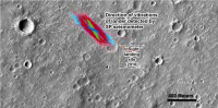
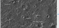
I will probably regret this, but just for the sake of having something out there, this is my guess as to the location of InSight. My circular panorama needs to be rotated a bit clockwise to fit this - its orientation was only approximate anyway. And this is not a perfect solution, but it will have to do for now. Very soon we will have a HiRISE image to show the real location. The HiRISE image number is in the file name if you save it.
Phil
|
Posted by: elakdawalla Dec 8 2018, 12:15 AM
I've combined the map from today's press briefing with the information in https://twitter.com/MoonNext/status/1071112287543549953 to locate the landing site within the ellipse. They're still not sure exactly where it is, but it's somewhere near this dot.
|
Posted by: elakdawalla Dec 8 2018, 12:26 AM
Here's a full-res crop from https://www.uahirise.org/ESP_036761_1845 that covers the same area as in Mimoun's tweet, plus the same with IRB color overlaid. The color image was missing IR data for one piece of the swath; I copied in data from the green channel to fill that gap, matching the levels.
https://planetary.s3.amazonaws.com/assets/images/4-mars/2018/ESP_036761_1845_RED_crop.png
https://planetary.s3.amazonaws.com/assets/images/4-mars/2018/ESP_036761_1845_MRGB_crop.png
Posted by: elakdawalla Dec 8 2018, 12:47 AM
Also, I checked and there seems to be only one other HiRISE image that covers the same area: https://www.uahirise.org/ESP_037262_1845
https://www.uahirise.org/ESP_056198_1845 
Posted by: Phil Stooke Dec 9 2018, 03:16 AM
Another candidate location which matches the panorama better than the other one, including distant features, but has a few strikes against it as well. Neither site is perfect.
Phil
|
Posted by: PDP8E Dec 9 2018, 08:05 PM
In the immortal words of our Cartographer Phil Stooke... I'll probably regret this but...
It feels like matching features from orbit to the subtle features on this ground here is like some sort of crazy Rorschach Test... after a few hours you start believing any old theory
this is North about 1000 or so pixels from Phil's
|
Any word on the coming HiRISE image?
Posted by: HSchirmer Dec 9 2018, 08:39 PM

It feels like matching features from orbit to the subtle features on this ground here is like some sort of crazy Rorschach Test... after a few hours you start believing any old theory
Hmm "three amigos" for the hills...
Does the Insight Team have any naming conventions yet for objects?
Three hills in the distance...
Westerns= Buono, Brutto, Cattivo? (Good, Bad, Ugly?)
Comedies= Steve Martin, Martin Short, Chevy Chase...
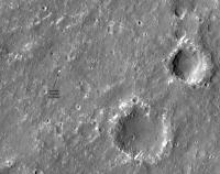
Posted by: volcanopele Dec 13 2018, 05:37 PM
HiRISE has posted image(s) of the InSight hardware on the surface:
https://www.uahirise.org/releases/insight/hardware/
As far as where that is WRT the landing ellipse: https://photojournal.jpl.nasa.gov/catalog/PIA22878
Posted by: elakdawalla Dec 13 2018, 07:41 PM
https://twitter.com/rocdocmars/status/1073290734256574464
Planetographic:4.5510° N, 224.4755° W
Planetocentric:4.499897° N, 135.616000° E
Parachute:
Planetographic:4.5424° N, 224.4707° W
Planetocentric:4.491393° N, 135.620800° E
Heat Shield:
Planetographic:4.5570° N, 224.4640° W
Planetocentric:4.505831° N, 135.627500° E
http://www.planetary.org/blogs/emily-lakdawalla/2018/hirise-insight-mars.html
Posted by: vikingmars Dec 14 2018, 07:07 AM
Phil
Quite good Phil : your estimate was 300 m SSE from the real position. Congratulations

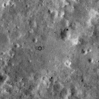
Posted by: Phil Stooke Dec 14 2018, 06:31 PM
Not good enough! Must try harder.
Here is a pre-landing image, clearer than the new image, showing the location of the lander. I registered the post-landing image with this to be sure the location is exact. This image is map-projected (north at the top). The press release image is in its non-map-projected format, slightly rotated clockwise from this. The image number is in the file name if you save it.
Phil
|
Posted by: elakdawalla Dec 14 2018, 09:55 PM
New official locations, based on a map-projected version of the HiRISE image, courtesy of Livio:
ocentric:135.6180° E, 4.4988° N
ographic:135.6180° E, 4.5520° N
Parachute
ocentric:135.6227° E, 4.4903° N
ographic:135.6227° E, 4.5434° N
Backshell
ocentric:135.6224° E, 4.4905° N
ographic:135.6224° E, 4.5436° N
Heat Shield
ocentric:135.6295° E, 4.5047° N
ographic:135.6295° E, 4.5580° N
Posted by: wildespace Dec 15 2018, 03:19 PM
A gif of before and after the landing I just made, using https://hirise.lpl.arizona.edu/ESP_037262_1845
|
Now let's try to spot the landscape features visible in InSight's images.
[Edit] Here are some of the large-ish boulders I think I identified in sol14 panorama (using Phil Stooke's image for inlay):
|
The boulder on the right end of the panorama is also identifiable (south of the lander)
Posted by: nogal Dec 17 2018, 01:26 AM
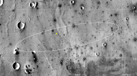
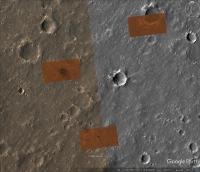
Here is, ready for Google Mars, an orbital map of the InSight landing area. It is a rectangle of roughly 2.82x2.56 km cropped from HiRISE image ESP_036761_1845, specifically from the Merged RGB (MRGB) product.
I registered it using the coordinates tweeted by Livio Tornabene, thank you Livio! The MRGB image has a resolution of 0.5m and Livio's coordinates' accuracy is about 6m, meaning there is room for relocation...
Since the map is 34MB big I can't post it here. Instead I placed it in Google Drive, here is the link: https://drive.google.com/open?id=1J5Xg14PSGSmOGORiefziAg8ITvXXoW_Y
I also added the three hardware cutouts from ESP_058005_1845 to InSight EDL kml file. So if you dowload the above file and install it, then download and install this file InSight_EDL_Sim.kmz ( 1.3MB )
: 1152
InSight_EDL_Sim.kmz ( 1.3MB )
: 1152
you will be able to see the hardware superimposed on the orbital map, like this:
|
You will notice some misadjustments between the HW cutouts and the base map, despite having spent several hours doing location adjustments. I think this is because, as Phil pointed out, the cutouts are not map projected. So, once the full ESP_058005_1845 image is available I may revisit this. Enjoy
Fernando
Posted by: PaulH51 Dec 17 2018, 02:03 AM
Both links worked like a charm, many thanks Fernando
Posted by: nogal Dec 17 2018, 12:42 PM
Thank you for the feedback Paul. If anyone runs into problems or finds any error please let me know, I'll do my best to correct it.
Fernando
Posted by: PaulH51 Jan 9 2019, 08:17 PM
HiRISE have published the processed images of the InSight hardware on the ground
See this tweet for details https://twitter.com/HiRISE/status/1083048771129204736
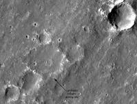
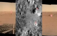
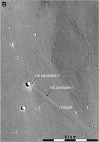
Posted by: Phil Stooke Jan 9 2019, 11:00 PM
Nice - and from it I have tentatively identified the so-called distant hill which I pointed out earlier. However, it may be a larger feature outside the HiRISE image, and I have not yet had a chance to check that.
|
Phil
EDIT - now I have checked it. There is a nice candidate further out, as shown below. I don't know the exact azimuth of the hill so the location of my sight line on the crater rim may be a bit off. When we have a full horizon panorama I can be more precise.
Phil
|
Posted by: wildespace Jan 12 2019, 01:45 PM
Full observation page is up at HiRISE: https://www.uahirise.org/ESP_058005_1845
https://twitter.com/HiRISE/status/1083048771129204736
Powered by Invision Power Board (http://www.invisionboard.com)
© Invision Power Services (http://www.invisionpower.com)