Yutu-2 route map |

  |
Yutu-2 route map |
 Apr 27 2021, 06:07 AM Apr 27 2021, 06:07 AM
Post
#76
|
||
|
Solar System Cartographer  Group: Members Posts: 10153 Joined: 5-April 05 From: Canada Member No.: 227 |
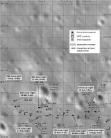
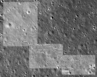
This is a very rough map for lunar day 29. Up to the 28th night it is based on Chinese maps. For day 29 I only have a distance. If we get a drive diary I may be able to add more detail, but last month there was no drive diary (that I am aware of) for the first time in 2 years.
Phil
-------------------- ... because the Solar System ain't gonna map itself.
Also to be found posting similar content on https://mastodon.social/@PhilStooke Maps for download (free PD: https://upload.wikimedia.org/wikipedia/comm...Cartography.pdf NOTE: everything created by me which I post on UMSF is considered to be in the public domain (NOT CC, public domain) |
|
 |
 
|
|
|
May 9 2021, 02:14 AM
Post
#77
|
||
|
Solar System Cartographer Group: Members Posts: 10153 Joined: 5-April 05 From: Canada Member No.: 227 |
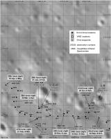
A drive diary did show up here:
https://www.163.com/dy/article/G9E3124Q0531TTYW.html (they can appear in various places. Thanks to Andrew Jones for pointing out another version of this) And it allows me to update the map. Still a bit uncertain in the last 2 drives. Phil
-------------------- ... because the Solar System ain't gonna map itself.
Also to be found posting similar content on https://mastodon.social/@PhilStooke Maps for download (free PD: https://upload.wikimedia.org/wikipedia/comm...Cartography.pdf NOTE: everything created by me which I post on UMSF is considered to be in the public domain (NOT CC, public domain) |
|
|
|
|
|
|
May 12 2021, 01:01 PM
Post
#78
|
||||
 Member Group: Members Posts: 185 Joined: 4-January 19 Member No.: 8523 |
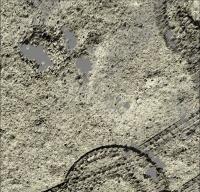
The PCAM stereo clusters of images from Yutu-2 allow to generate 3d models of the path on almost a mm resolution. Its interesting to understand the craters patterns on the path.
The smallest craters are within 20 cm of diameters and they exist all over the soil, like a pattern over it. Its interesting to see how the craters overlap beetween each other. They didn't choose a path without craters, but which path has the smallest craters. Data working with from moon.bao.ac.cn, PCAM images from jan19 to mar20. I haven't seen any PCAM batch of images after this date, if anyone has that i would apreciate the link.
Attached thumbnail(s)
-------------------- "The Earth is a very small stage in a vast cosmic arena"
|
|||
|
|
|
|||
|
May 12 2021, 11:39 PM
Post
#79
|
||
|
Solar System Cartographer Group: Members Posts: 10153 Joined: 5-April 05 From: Canada Member No.: 227 |
The first big data release covered that period you mentioned. Since the there have been several smaller releases. They are listed here:
https://moon.bao.ac.cn/
(right side in the data release window) You can see there also data sets from CE5 and the international experiments carried on CE4. Phil -------------------- ... because the Solar System ain't gonna map itself.
Also to be found posting similar content on https://mastodon.social/@PhilStooke Maps for download (free PD: https://upload.wikimedia.org/wikipedia/comm...Cartography.pdf NOTE: everything created by me which I post on UMSF is considered to be in the public domain (NOT CC, public domain) |
|
|
|
|
|
|
May 13 2021, 10:53 AM
Post
#80
|
||
|
Member Group: Members Posts: 185 Joined: 4-January 19 Member No.: 8523 |
The most recents there are from Apr 2020. On Scientific Data, CE4, PCAM, 2B.
So i believe that they are puting the data online 1 year after geting it...
Attached thumbnail(s)
-------------------- "The Earth is a very small stage in a vast cosmic arena"
|
|
|
|
|
|
|
Jul 8 2021, 06:37 AM
Post
#81
|
||
|
Solar System Cartographer Group: Members Posts: 10153 Joined: 5-April 05 From: Canada Member No.: 227 |
Very little news about Yutu 2 except a statement about driving 30 m during the 31st day. This is just a rough idea of where the rover may be. We are into day 32 now (probably in the noon-time siesta period).
Phil
-------------------- ... because the Solar System ain't gonna map itself.
Also to be found posting similar content on https://mastodon.social/@PhilStooke Maps for download (free PD: https://upload.wikimedia.org/wikipedia/comm...Cartography.pdf NOTE: everything created by me which I post on UMSF is considered to be in the public domain (NOT CC, public domain) |
|
|
|
|
|
|
Sep 5 2021, 03:21 AM
Post
#82
|
||
|
Solar System Cartographer Group: Members Posts: 10153 Joined: 5-April 05 From: Canada Member No.: 227 |
Not much news lately except distances driven. Just for the sake of having something to post, here is a very crude estimate of locations up to the end of lunar day 33.
Phil
-------------------- ... because the Solar System ain't gonna map itself.
Also to be found posting similar content on https://mastodon.social/@PhilStooke Maps for download (free PD: https://upload.wikimedia.org/wikipedia/comm...Cartography.pdf NOTE: everything created by me which I post on UMSF is considered to be in the public domain (NOT CC, public domain) |
|
|
|
|
|
|
Sep 29 2021, 06:52 PM
Post
#83
|
||
|
Solar System Cartographer Group: Members Posts: 10153 Joined: 5-April 05 From: Canada Member No.: 227 |
Finally - an update on Chang'e 4 and Yutu 2. Thanks to Andrew Jones for finding it. This map goes up to the 34th night - which is just ending as I post this. The 40 m drive in lunar day 34 was the longest since the 3rd lunar day.
Phil
-------------------- ... because the Solar System ain't gonna map itself.
Also to be found posting similar content on https://mastodon.social/@PhilStooke Maps for download (free PD: https://upload.wikimedia.org/wikipedia/comm...Cartography.pdf NOTE: everything created by me which I post on UMSF is considered to be in the public domain (NOT CC, public domain) |
|
|
|
|
|
|
Sep 30 2021, 12:44 AM
Post
#84
|
||
|
Solar System Cartographer Group: Members Posts: 10153 Joined: 5-April 05 From: Canada Member No.: 227 |
Here is a full route map for Yutu 2 combining the separate maps I have been making.
Phil
-------------------- ... because the Solar System ain't gonna map itself.
Also to be found posting similar content on https://mastodon.social/@PhilStooke Maps for download (free PD: https://upload.wikimedia.org/wikipedia/comm...Cartography.pdf NOTE: everything created by me which I post on UMSF is considered to be in the public domain (NOT CC, public domain) |
|
|
|
|
|
|
Oct 26 2021, 08:04 PM
Post
#85
|
||
|
Solar System Cartographer Group: Members Posts: 10153 Joined: 5-April 05 From: Canada Member No.: 227 |
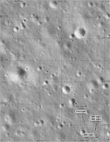
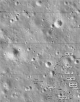
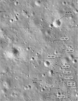
An update at this site:
https://mp.weixin.qq.com/s/_zVG8NHfwZWzXWhdGWHJlg gives a new map and some images. Here is an updated map:
The turtle name refers to a group of craters surrounding a shallow degraded crater which is the turtle shell (looks more like a turtle in images with more contrast and evening lighting). The valley mentioned here refers to a historic military event, a detour which took an army off the main route as part of a major campaign. The path here was a detour around a crater and to the northwest after a few days of moving mainly west. Phil -------------------- ... because the Solar System ain't gonna map itself.
Also to be found posting similar content on https://mastodon.social/@PhilStooke Maps for download (free PD: https://upload.wikimedia.org/wikipedia/comm...Cartography.pdf NOTE: everything created by me which I post on UMSF is considered to be in the public domain (NOT CC, public domain) |
|
|
|
|
|
|
Nov 4 2021, 01:59 AM
Post
#86
|
||
|
Solar System Cartographer Group: Members Posts: 10153 Joined: 5-April 05 From: Canada Member No.: 227 |
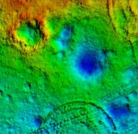
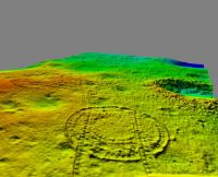
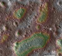
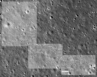
You might enjoy this map showing the landing region with topography and the route so far.
The base image is an ortho image from LRO. The topography is from Figure 1 in this paper: Xiao, Z., Ding, C., Xie, M., Cai, Y., Cui, J., Zhang, K. and Wang, J., 2021. Ejecta From the Orientale Basin at the Chang'E‐4 Landing Site. Geophysical Research Letters, 48(3), p.e2020GL090935. Blue and green areas are low, red and neutral shades are high. The total range of topography is about 20 m. The top left corner of the map is the basaltic region which is a long-term goal for Yutu 2. It would take another 4 years to get there at the current rate. Phil
-------------------- ... because the Solar System ain't gonna map itself.
Also to be found posting similar content on https://mastodon.social/@PhilStooke Maps for download (free PD: https://upload.wikimedia.org/wikipedia/comm...Cartography.pdf NOTE: everything created by me which I post on UMSF is considered to be in the public domain (NOT CC, public domain) |
|
|
|
|
|
|
Dec 3 2021, 08:19 AM
Post
#87
|
||
|
Solar System Cartographer Group: Members Posts: 10153 Joined: 5-April 05 From: Canada Member No.: 227 |
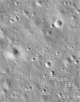
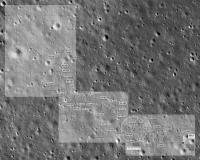
This is an update for lunar day 36. The drive during day 36 is an interpretation from the latest drive diary, partly based on images in that diary. I may be correcting this soon!
The large rock on the northern horizon (described and illustrated in the drive diary) is on the rim of the prominent crater about 75 m north of the current position. That crater and the blocks on its rim will be reached after 2 or 3 lunar days driving. Phil
-------------------- ... because the Solar System ain't gonna map itself.
Also to be found posting similar content on https://mastodon.social/@PhilStooke Maps for download (free PD: https://upload.wikimedia.org/wikipedia/comm...Cartography.pdf NOTE: everything created by me which I post on UMSF is considered to be in the public domain (NOT CC, public domain) |
|
|
|
|
|
|
Dec 3 2021, 08:29 AM
Post
#88
|
||
|
Solar System Cartographer Group: Members Posts: 10153 Joined: 5-April 05 From: Canada Member No.: 227 |
And the full map including the last few months.
Phil
-------------------- ... because the Solar System ain't gonna map itself.
Also to be found posting similar content on https://mastodon.social/@PhilStooke Maps for download (free PD: https://upload.wikimedia.org/wikipedia/comm...Cartography.pdf NOTE: everything created by me which I post on UMSF is considered to be in the public domain (NOT CC, public domain) |
|
|
|
|
|
|
Dec 5 2021, 10:29 PM
Post
#89
|
|
|
Member Group: Members Posts: 401 Joined: 5-January 07 From: Manchester England Member No.: 1563 |
Thanks for keeping the updates going Phil, it's much appreciated!
-------------------- |
|
|
|
|
Jan 4 2022, 04:25 AM
Post
#90
|
|||
|
Solar System Cartographer Group: Members Posts: 10153 Joined: 5-April 05 From: Canada Member No.: 227 |
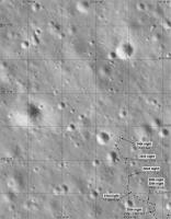
A Chinese map up to the 37th day has been released, though not at a very legible scale yet. I have used it to update my map, but this might be improved when a better original shows up.
I am making the assumption that the 'Mystery House' is on the far rim of the crater, not the southern rim. Phil
-------------------- ... because the Solar System ain't gonna map itself.
Also to be found posting similar content on https://mastodon.social/@PhilStooke Maps for download (free PD: https://upload.wikimedia.org/wikipedia/comm...Cartography.pdf NOTE: everything created by me which I post on UMSF is considered to be in the public domain (NOT CC, public domain) |
||
|
|
|
||
|

|
Lo-Fi Version | Time is now: 27th April 2024 - 09:21 AM |
|
RULES AND GUIDELINES Please read the Forum Rules and Guidelines before posting. IMAGE COPYRIGHT |
OPINIONS AND MODERATION Opinions expressed on UnmannedSpaceflight.com are those of the individual posters and do not necessarily reflect the opinions of UnmannedSpaceflight.com or The Planetary Society. The all-volunteer UnmannedSpaceflight.com moderation team is wholly independent of The Planetary Society. The Planetary Society has no influence over decisions made by the UnmannedSpaceflight.com moderators. |
SUPPORT THE FORUM Unmannedspaceflight.com is funded by the Planetary Society. Please consider supporting our work and many other projects by donating to the Society or becoming a member. |
|