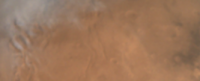
MOM archival data |

  |
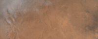
MOM archival data |
| Guest_avisolo_* |
 Oct 6 2016, 06:13 AM Oct 6 2016, 06:13 AM
Post
#16
|
|
Guests |
Here's my version:

|
 |
 
|
|
Oct 6 2016, 08:24 AM
Post
#17
|
|
|
Member  Group: Members Posts: 923 Joined: 10-November 15 Member No.: 7837 |
Yes I have the same problem with Chrome... a prominent green infecting all images, other browsers are fine. My Flickr timeline looks like Mars has been successfully terraformed.
QUOTE (jccwrt @ Oct 6 2016, 12:28 AM)  There might be something up with the color profiles - they display fine in Photoshop and Microsoft Photos, but then I get some green color banding when I view them in Chrome. Any ideas? -------------------- |
|
|
|
|
Oct 6 2016, 04:21 PM
Post
#18
|
|
 Senior Member Group: Members Posts: 3648 Joined: 1-October 05 From: Croatia Member No.: 523 |
QUOTE (elakdawalla @ Oct 5 2016, 03:09 AM) I need to do more work to match the Mars colors, I know. Are you using the MCC_MRC 16 bit or MCC_MRD 32 bit products? The MRDs are supposed to be radiometrically calibrated products, while the MRC are only the detector readout DNs. The former *theoretically* shouldn't produce brightness variations. -------------------- |
|
|
|
|
Oct 6 2016, 06:38 PM
Post
#19
|
|
 Administrator Group: Admin Posts: 5172 Joined: 4-August 05 From: Pasadena, CA, USA, Earth Member No.: 454 |
I haven't successfully opened the 32-bit data -- IMG2PNG doesn't open it and when I try it in Photoshop, it's all saturated. So I've been working with the 16-bit images.
-------------------- My website - My Patreon - @elakdawalla on Twitter - Please support unmannedspaceflight.com by donating here.
|
|
|
|
|
Oct 6 2016, 11:46 PM
Post
#20
|
|
|
Administrator Group: Admin Posts: 5172 Joined: 4-August 05 From: Pasadena, CA, USA, Earth Member No.: 454 |
OK, the entire dataset is now available here. I zipped every image to save on bandwidth consumption. Blog entry about it here.
I downloaded the "level 3" data, which is demosaicked and allegedly calibrated. I'm very curious to find out if different demosaicking methods produce sharper results. Here is one image (the global view with the Tharsis montes and Valles Marineris), in its raw format, and here is its label. Can any of you do better than the mission's version, which used bilinear interpolation for demosaicking? -------------------- My website - My Patreon - @elakdawalla on Twitter - Please support unmannedspaceflight.com by donating here.
|
|
|
|
|
Oct 8 2016, 01:43 AM
Post
#21
|
|||
 IMG to PNG GOD Group: Moderator Posts: 2254 Joined: 19-February 04 From: Near fire and ice Member No.: 38 |
QUOTE (elakdawalla @ Oct 6 2016, 11:46 PM) Can any of you do better than the mission's version, which used bilinear interpolation for demosaicking? Somewhat disappointingly, this comparison seems to be difficult or impossible since inspection of the images reveals that the official images (both the 16 and 32 bit versions) have also had additional processing applied to them. In particular, they have been smoothed, possibly flatfielded and I suspect the brightness may have been adjusted with a (slightly) nonlinear stretch. Here is a crop showing a comparison between the official version (top) and a version I did using IMG2PNG to output a debayered image using adaptive smooth hue (bottom) for demosaicking.
The bottom version looks sharper but it's also a lot more noisy. This is especially clear if the images are sharpened. I will be releasing a new version of IMG2PNG that handles these images properly tomorrow (Saturday). |
||
|
|
|
||
|
Oct 10 2016, 07:37 PM
Post
#22
|
|
|
Administrator Group: Admin Posts: 5172 Joined: 4-August 05 From: Pasadena, CA, USA, Earth Member No.: 454 |
Given Bjorn's observations above, I thought it would be valuable to go ahead and download all of the raw (undebayered) data. I've now done this and posted all the raw images to the MCC page. I'm working on running it through the new version of IMG2PNG.
-------------------- My website - My Patreon - @elakdawalla on Twitter - Please support unmannedspaceflight.com by donating here.
|
|
|
|
|
Sep 29 2017, 02:18 PM
Post
#23
|
|
|
Solar System Cartographer Group: Members Posts: 10229 Joined: 5-April 05 From: Canada Member No.: 227 |
There's a new ISRO data release from MOM. Emily's working on it but I note it does include some small images of Deimos.
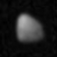 I'm still pondering which part of Deimos this is (as one does). I wonder if MOM can be brought closer to Deimos... the anti-Mars side and trailing side have never been seen very well, and a high resolution view of that region would be a substantial scientific advance. If MOM can't do it, there may be hope for this from the UAE's Hope mission (2020 launch), which will have an orbit which might bring it closer to Deimos. Phil -------------------- ... because the Solar System ain't gonna map itself.
Also to be found posting similar content on https://mastodon.social/@PhilStooke Maps for download (free PDF: https://upload.wikimedia.org/wikipedia/comm...Cartography.pdf NOTE: everything created by me which I post on UMSF is considered to be in the public domain (NOT CC, public domain) |
|
|
|
|
Oct 2 2017, 01:17 AM
Post
#24
|
|
|
Member Group: Members Posts: 923 Joined: 10-November 15 Member No.: 7837 |
Thanks to Emily for making the dataset available, looking forward to the next batch!
Here is the first portrait of Mars taken on September 28th 2014, upscaled to 64 Megapixel & processed...  -------------------- |
|
|
|
|
Oct 3 2017, 01:15 AM
Post
#25
|
|
|
Administrator Group: Admin Posts: 5172 Joined: 4-August 05 From: Pasadena, CA, USA, Earth Member No.: 454 |
Here you go. Go nuts, everybody!
-------------------- My website - My Patreon - @elakdawalla on Twitter - Please support unmannedspaceflight.com by donating here.
|
|
|
|
|
Oct 3 2017, 03:35 PM
Post
#26
|
|
|
Member Group: Members Posts: 923 Joined: 10-November 15 Member No.: 7837 |
Thanks for doing such an amazing job making this accessible Emily.
Here is a 384 megapixel global portrait sequence... [ upscaled & processed ]  Some select 64 megapixel portraits...   
-------------------- |
|
|
|
|
Oct 3 2017, 11:23 PM
Post
#27
|
|
|
Administrator Group: Admin Posts: 5172 Joined: 4-August 05 From: Pasadena, CA, USA, Earth Member No.: 454 |
You're welcome! Let me know if there's something else I can do that would make those pages even more helpful. I can't guarantee I'll do it, but there's no harm suggesting...

-------------------- My website - My Patreon - @elakdawalla on Twitter - Please support unmannedspaceflight.com by donating here.
|
|
|
|
|
Oct 5 2017, 03:48 PM
Post
#28
|
|
|
Member Group: Members Posts: 923 Joined: 10-November 15 Member No.: 7837 |
I can't imagine the material could be presented any better than it is. I loved the context maps also.
In case anyone wants a 2m square print [ 150dpi ] of the 22nd January 2016 portrait...  *update* Ouch! What was I thinking!? 
-------------------- |
|
|
|
|
Oct 5 2018, 05:29 AM
Post
#29
|
|
|
Administrator Group: Admin Posts: 5172 Joined: 4-August 05 From: Pasadena, CA, USA, Earth Member No.: 454 |
Hi folks, I'm still working on providing context, but here is year 3 of the Mars Orbiter MCC data. Nearly all of it was taken at periapsis, within 2000 or fewer km of the surface. This is unfortunate because it's what MCC is least good at -- it's at its best when doing regional imaging. Still, there may be some scope for fun here. Please share anything you produce from it. I'll keep working on more context info and post a blog about it tomorrow.
-------------------- My website - My Patreon - @elakdawalla on Twitter - Please support unmannedspaceflight.com by donating here.
|
|
|
|
|
Oct 6 2018, 12:45 AM
Post
#30
|
|
 Member Group: Members Posts: 291 Joined: 29-December 05 From: Ottawa, ON Member No.: 624 |
I wont embarrass myself by posting any of the images I worked on, but even the really dark imagery has a wealth of detail with just an auto levels click of the mouse.
|
|
|
|
|

|
Lo-Fi Version | Time is now: 27th September 2024 - 03:45 AM |
|
RULES AND GUIDELINES Please read the Forum Rules and Guidelines before posting. IMAGE COPYRIGHT |
OPINIONS AND MODERATION Opinions expressed on UnmannedSpaceflight.com are those of the individual posters and do not necessarily reflect the opinions of UnmannedSpaceflight.com or The Planetary Society. The all-volunteer UnmannedSpaceflight.com moderation team is wholly independent of The Planetary Society. The Planetary Society has no influence over decisions made by the UnmannedSpaceflight.com moderators. |
SUPPORT THE FORUM Unmannedspaceflight.com is funded by the Planetary Society. Please consider supporting our work and many other projects by donating to the Society or becoming a member. |
|