Printable Version of Topic
Click here to view this topic in its original format
Unmanned Spaceflight.com _ Past and Future _ Viking 1 & 2 landers from HiRISE
Posted by: elakdawalla Dec 4 2006, 11:19 PM
Thought I'd start a new topic for the HiRISE images of the Viking 1 and 2 landers:
http://hiroc.lpl.arizona.edu//images/PSP/PSP_001521_2025/
http://hiroc.lpl.arizona.edu//images/PSP/PSP_001501_2280/
--Emily
Posted by: elakdawalla Dec 4 2006, 11:23 PM
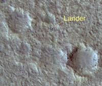
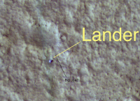
I want to congratulate Phil Stooke for his right-on location of the Viking 1 lander site:
HiRISE location:
|
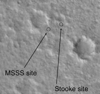
MSSS and Phil's locations:
|
--Emily
Posted by: elakdawalla Dec 4 2006, 11:34 PM
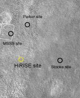
...and it looks like nobody got the Viking 2 site. Here's Phil's map, with the actual location circled. There is a spot in the MOC image that can be identified as the lander, with the benefit of the HiRISE location.
|
--Emily
Posted by: stevesliva Dec 4 2006, 11:41 PM
Wow. Very impressive stuff. (And an attaboy for Phil)
Posted by: tuvas Dec 4 2006, 11:41 PM

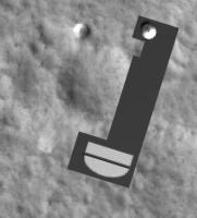
|
|
--Emily
I was the first to find the MSSS site, it turns out that is the backshell.
Posted by: craigmcg Dec 4 2006, 11:49 PM
What's the scale - how far apart are the different estimates?
Posted by: ElkGroveDan Dec 4 2006, 11:52 PM
Wow, thanks Emily for digging that up quick! That was the first thing I was going to check for. High fives all around Phil!
Posted by: djellison Dec 4 2006, 11:55 PM
Well - that chute really doesn't need a question mark  Awesome images! That the chute is at all visible after 30 years is amazing.
Doug
|
Posted by: AlexBlackwell Dec 4 2006, 11:56 PM
I'd like to add congrats to Phil, too. I've followed his work, and recall his 1997 http://www.springerlink.com/content/q564g71221441576/?p=d33a190c0fc64e85a67e84264a6814fc&pi=2 in Earth, Moon, and Planets.
Posted by: kenny Dec 5 2006, 12:11 AM
Congrats encore. I suppose the Viking 2 chute must be there too, just twisted up and covered with dust, and therefore well camouflaged?
Looking forward to seeing Mars 3 perhaps, and an answer to the failure theory that its TV camera was covered with its own parachute.
Kenny
Posted by: tim53 Dec 5 2006, 12:27 AM
Awesome images! That the chute is at all visible after 30 years is amazing.Doug
Doug:
I didn't want to put the question mark on the annotated version, but Alfred preferred it. In the end, there is really no way to be 100.000% certain that it is the parachute, though I think I'm about 99% sure it is

Just a historical self-horn-tooting note:
Both the MOC C-PROTO and HiRISE images for the two Viking landers were targeted to those locations based on work I did after the Pathfinder landing, when it was discovered that the Viking-based control net for Mars was imprecise enough that Pathfinder landed 18 kilometers east of where we thought it would. Thankfully, I had plenty of mid to far field topographic features to triangulate to that could be seen even in the 40m/pixel Viking Orbiter images, which were all we had to work with due to the loss of Mars Observer. So many, in fact, that I was able to place the landing site within 12 hours of landing, and with only 60 degrees of the horizon pan down.
But, based on this eastward offset from where we expected to land, I started looking at the VL-1 site again. At the same time, Malin's team and the DLR scientists were aware of the discrepency, and approached it from other directions - agreeing that VL-1 (and probably VL-2, though it's location was less precisely known than VL-1) was probably really east of the Viking Team's location by about 6 kilometers. It didn't take long for me to find a better match between the ground and orbiter views for VL-1, because there was a 7m/pixel image from Viking Orbiter to work with. As soon as MOC images were acquired of the "real" location, I poured over them and fine-tuned my location. By the time the MOC C-PROTO was acquired, I knew where the lander would be found to within a few meters, even though the C-PROTO did not reveal the lander. The lander turned out to be within a few meters of my predicted location.
VL-2 was a tougher problem, because the topography is so subtle, and because the view to the southwest is largely obscured by the nearby rocky ridge. Phil's technique of vertically exaggerating the horizon helped quite a bit. I used the same technique after compiling a "super resolution" product by co-adding multiple images of the same scene to bring out finer detail and reduce noise. I then triangulated to the various horizon features I could identify, and found a tentative match (plotted in one of the posts above). Ironically, I picked the "wrong" degraded crater west of the lander to correlate the mid-field to. Now that I know where the lander is, if I move my vector plot to that location, I get a good match with the features.
Now, I'm eagerly anticipating the HiRISE image of MPF! The more hardware they capture, the more of a feel we'll have for what hardware looks like on the surface of Mars, and the better our chances of locating landers for which we have no ground images - useful for failure analyses.
-Tim.
Posted by: AlexBlackwell Dec 5 2006, 12:32 AM
That'll be the money shot, in my opinion.
Posted by: tim53 Dec 5 2006, 12:54 AM
I just saw the press release as it went out.
After it went out, a colleague of mine and I realized that the name for the VL-2 rock "Ankylosaurus" may not have been one used by the Viking team as a whole. I got that name via the late Henry Moore, during the Pathfinder mission, when I was putting together a stereo anaglyph of that rock to understand it's shape better.
Apologies if it's not the rock's official designation.
-Tim.
Posted by: Phil Stooke Dec 5 2006, 01:20 AM
Tim got the Viking 1 position with a great bit of detective work using the barely adequate Viking images. At the time he did it, people had become convinced that the original identification was wrong. That dated back to about 1980, but when Pathfinder landed not too far away the tracking coordinates and image locations for the two landers together could not be made to match. Pathfinder was not in doubt (another Tim discovery) so Viking had to be wrong.
Mert Davies of RAND calculated a site off to the west from the original estimate (so did others, including, if I recall correctly without going into my files, Tom Duxbury at JPL and Oberst's team at DLR). I think several people were loking in the images for a better site. Mert Davies suggested a specific location to me and I found a crummy match to the panoramas near that location (lesson - you can convince yourself of a bad match quite easily), but he eventually refined his calculations and it moved to a point closer to the location Tim found.
Now I'm looking forward to Pathfinder. I think I posted a predicted location recently - just a few MOC pixels off the site MSSS give on their website.
Phil
Posted by: AlexBlackwell Dec 5 2006, 01:30 AM
Phil: I haven't checked but do you happen to know how close http://dx.doi.org/10.1016/0019-1035(80)90067-6 got with their VL1 estimate?
Posted by: Phil Stooke Dec 5 2006, 01:36 AM
I don't have the maps in front of me but it was maybe 10 km southeast of the true site.
Of course, all these early attempts (Morris and Jones, then the botched job I did, and then Tim's successful find) were not identifying the lander itself, they were triangulating the lander location based on the pattern of ridges (mostly crater rims) around the lander. The best Viking mosaic was about 8 m/pixel and very low contrast.
My result is in an LPSC abstract from about 1998.
Phil
Posted by: Phil Stooke Dec 5 2006, 01:54 AM
I should add this, too... it looks like MSSS were absolutely correct in their Viking 2 identification, except that they found the backshell instead of the lander.
Phil
Posted by: tuvas Dec 5 2006, 05:29 AM
Phil
Ahh, the backshell. I was wondering what that was... That makes absolute sense now, it hadn't beforehand. For some reason I thought there was only two parts to the Vikings, and I guess there was 3. Oh well.
Posted by: tim53 Dec 5 2006, 05:44 AM
I believe it was just under 6 km west southwest of the actual location. Crater "A" was mischosen. It was because I could see boulders on its rim, and knew what they looked like relative to the larger "Big Crater" at MPF that made me first realize that the crater on the VL-1 horizon couldn't be that big, because the boulders would have been absurdly large by comparison. Once I realized that, it took little time to find a better match to the horizon vecots.
-Tim.
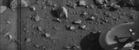
Posted by: Ant103 Dec 5 2006, 08:35 AM
Incredible! It's simply incredible! 30 years after, we meet one time again the landers! 
Congratulation for everybody
It think that I found Big Joe, no?
|
Posted by: Ian R Dec 5 2006, 09:20 AM
Also called: "The Rock Formerly Known as 'Big Bertha'".

These are really great images - my congratulations to everbody involved with HiRISE and MRO.
Ian.
Posted by: remcook Dec 5 2006, 10:47 AM
did anyone comment yet on how amazing this all is? oh yes, they did....
Really thrilled and excited about all this. We really live in a good time for space exploration!
Posted by: Myran Dec 5 2006, 12:28 PM
Yes it seems quite likely you spotted the rock in question.
I remember from published comments of that day that they felt lucky that the Viking lander hadnt ended up on top of that rock and crashed or flipped over.
But yes remcook, its amazing, like seeing old friends after a very long time.
Posted by: gndonald Dec 5 2006, 02:18 PM
It's wonderful to see the landscapes that I gazed at in books during the 1980's from above, a fitting reward for the long years of waiting. Let's hope the bean counters don't spoil the party...
Posted by: Ant103 Dec 5 2006, 04:14 PM
Here is a more color-realistic view based on the hirise picture  (1,1 Mo)
http://www.studiolentigo.net/upload/Viking1LandingSite-color.jpg
Posted by: AlexBlackwell Dec 5 2006, 04:23 PM
Thanks, Tim (and to Phil above). It'll be interesting to see a composite map with the various Viking lander (and MPF, when available from HiRISE) position estimates, which would help illustrate how the Mars control net has evolved and improved over the decades.
Posted by: PhilCo126 Dec 5 2006, 05:30 PM
This certainly brings back some memories when I was writing to almost each of the NASA centers as a 10-year old and was amazed to get photos back from Dr Gentry LEE, Dr Jerry SOFFEN, Dr Edward Stone, Dr Charles HALL etc...


Posted by: dvandorn Dec 5 2006, 11:24 PM
(1,1 Mo)http://www.studiolentigo.net/upload/Viking1LandingSite-color.jpg
Wow! This view of the landscape is absolutely incredible. I've run out of superlatives -- I'm reminded of John Young, standing on the Moon, using the word 'spectacular' for the fourth time in five minutes, and then apologizing, saying you just run out of words...
From a geologic point of view, this image shows quite well that the boulder populations are concentrated on the floors and rims of depressions, but with a strong bias towards the west-northwest inner rims and east-southeast outer ramparts. This seems to match one of the two predominant sets of lineations; one set runs nearly horizontal through the scene, dipping only slightly to the south as it moves to the east, and seems to be composed mostly of dune, ripple and other aeolian features. The other set, which seems to align with the positioning bias of the boulder population, runs from east-southeast to west-northwest. (*) These lineations are rougher and expressed in larger features, the apparent sculpting of what now looks like a "scoured" terrain that, prior to the scouring event(s), featured a lot of 10- to 20-m craters.
Seeing as how the Chryse region was selected as a landing site because it's located in the midst of an apparent ancient catastrophic outflow channel, I guess you'd expect to see signs of directional scouring in the basic landforms. It looks to me like many of the boulders were deposited preferentially in the "downstream" sides of craters.
This image is, to me, far more compelling evidence of ancient catastrophic floods in the region than anything we actually saw from the surface.
* - All of the above directions assume that north is up in the image; I'm using them relative to this image only, and don't intend to convey that north is indeed straight up throughout the image.
-the other Doug
Posted by: Stu Dec 6 2006, 06:41 AM
Ant,
A very sincere thanks to you for posting that image. As it clearly has done for others here, it brought images flooding back for me. One of my first "encounters" with Mars, and probably what really fired up my passion for the planet, was coming across a National Geographic on a shelf in my art class at school (a great stack of old issues were kept there as reference material - great if you needed to know what African women with rings around their necks, or salmon leaping up streams looked like!). One day, probably when I should have been doing something else, I came across one of the issues showcasing images from the Vikings... wow, love at first sight! I must admit I sneaked the mag out of class and took it home where I drooled over those pictures again and again... it's still sat on my shelf over there, next to the Pathfinder 3D images issue...
So, seeing that colourised pic sent a real shiver through me. Thanks!
Posted by: SkyeLab Dec 6 2006, 09:12 AM
The BBC have picked up on these fantastic images:
http://news.bbc.co.uk/1/hi/sci/tech/6211870.stm
Brian
Posted by: vikingmars Dec 6 2006, 03:52 PM
...And the discovery of the location of the backshell and its parachute solves also a 30-year mistery : the darkening during a few seconds of the landing site as seen as a dark band in the 1st picture taken by VL1.
The very 1st lines at left of the image are light gray due to the moving dust raised by the engines (seen also on the 1st VL2 image) and then comes a much darker band. We were some people thinking that this darkening was made by the parachute that went in front of the Sun during its final descent. Because we were unable to see the backshell from the lander, we supposed that it was very close to the lander but hidden by one of the two nearest craters. Well this is the case !
Here are the 2 first images taken by VL1 showing the crater hidding the backshell and its now probable final landing trajectory (arrow).
|
|
|
Posted by: AlexBlackwell Dec 6 2006, 04:44 PM
Several years ago, I remember perusing a coffee table-type book on space exploration, and I noticed a high-resolution Viking orbiter picture of the VL1 landing site juxtaposed with an illustration depicting the VL1 aeroshell impacting the Martian surface. The caption accompanying both figures read:
QUOTEViking 1's sterilized protective aeroshell (left) gouged out a small crater, half a mile (750 metres) north of the lander site itself (small arrow). The crater (large arrow) was not discovered until orbiter pictures were analysed in 1987.
Unfortunately, the book didn't offer any references for the picture; however, four years ago I contacted Bob Craddock at NASM. Years earlier, he had submitted an abstract to the 1994 Mars Environmental Survey workshop entitled "Rationale for a Mars Pathfinder Mission to Chryse Planitia (20 Degrees N, 40 Degrees W) and the Viking 1 Lander." His abstract suggested that MPF could examine the hole gouged out by the VL1 aeroshell, and I thought he might be able to track down the reference I was looking for.
Craddock replied:
QUOTEUnfortunately the reference you are looking for as never been published in a peer-reviewed journal. While still at NASA Goddard, Jim Garvin together with Olivier de Goursac from France's Promospace determined what would have been the most likely trajectory for the Viking aeroshell. They then examined photographs of the landing area taken after the spacecraft was on the surface and suggested that a small depression may have been created by the aeroshell. All of this came out in a half-page article in Aviation Week and Space Technology published on June 22, 1987, pages 84-85. The article does not reference an author. I asked Jim as to how the article got published, but that was years ago and I can't remember the story now.
I contacted Garvin at about the same time (ca. 2002), and he replied "I will look into it. I did that work with Olivier for fun, and it was 'published' in a magazine, not a peer-reviewed journal. It's been a while and my files are buried in deep vault storage at GSFC. Let me see what I can dig up!"
I just realized that I never followed-up with him
Posted by: tim53 Dec 6 2006, 06:30 PM
...And the discovery of the location of the backshell and its parachute solves also a 30-year mistery : the darkening during a few seconds of the landing site as seen as a dark band in the 1st picture taken by VL1. The very 1st lines at left of the image are light gray due to the moving dust raised by the engines (seen also on the 1st VL2 image) and then comes a much darker band. We were some people thinking that this darkening was made by the parachute that went in front of the Sun during its final descent. Because we were unable to see the backshell from the lander, we supposed that it was very close to the lander but hidden by one of the two nearest craters. Well this is the case !
Here are the 2 first images taken by VL1 showing the crater hidding the backshell and its now probable final landing trajectory (arrow).
The backshell and parachute most likely impacted the surface before the lander touched down. Even without the weight of the lander, in the thin Martian atmosphere, the backshell and parachute (still inflated since they didn't use RAD rockets to slow the descent) would have been traveling at about 100mph.
-Tim.
Posted by: tim53 Dec 6 2006, 06:31 PM
I remember that Aviation Week article. Simply put, they misidentified features on the ground and noise in the images as hardware.
-Tim.
[/indent]
Unfortunately, the book didn't offer any references for the picture; however, four years ago I contacted Bob Craddock at NASM. Years earlier, he had submitted an abstract to the 1994 Mars Environmental Survey workshop entitled "Rationale for a Mars Pathfinder Mission to Chryse Planitia (20 Degrees N, 40 Degrees W) and the Viking 1 Lander." His abstract suggested that MPF could examine the hole gouged out by the VL1 aeroshell, and I thought he might be able to track down the reference I was looking for.
Craddock replied:
[indent]
I contacted Garvin at about the same time (ca. 2002), and he replied "I will look into it. I did that work with Olivier for fun, and it was 'published' in a magazine, not a peer-reviewed journal. It's been a while and my files are buried in deep vault storage at GSFC. Let me see what I can dig up!"
I just realized that I never followed-up with him
Posted by: Ant103 Dec 6 2006, 06:48 PM
[out_of-subjectmode]Oh? Olivier, qu'est-ce que tu deviens? On te vois pas beacoup ces temps-ci [/out__subjectmode]
The shadow of the parachute? I was thinking that it was CCD lines those are due to the very beginning of the camera activity  ... It's very linear...
Posted by: AlexBlackwell Dec 6 2006, 06:50 PM
What I didn't post was a comment from another, prominent Mars scientist when I asked him about this whole issue: "It's was a bunch of nonsense."
Posted by: tim53 Dec 6 2006, 07:06 PM
I bet I can guess who that was!
Posted by: tim53 Dec 6 2006, 07:18 PM
[/out__subjectmode]The shadow of the parachute? I was thinking that it was CCD lines those are due to the very beginning of the camera activity
... It's very linear...The Viking lander cameras didn't use CCDs, but photodiodes whereby an image was slowly built up by tilting a tiny mirror up and down and rotating the whole camera body in azimuth to add "pixels" to the scene. The vertical bands are due to lighting changing as the scene was acquired, due to dust from the landing settling over the several minutes it took to take the picture.
The parachute would have settled onto the surface in a fraction of a second after the backshell landed. There might have been dust kicked up, but it's affect on the lander is probably much less than that of the lander's descent engines locally.
-Tim.
Posted by: AlexBlackwell Dec 6 2006, 07:21 PM
I'm sure you could, Tim. As I gather it, that's one of his favorite phrases

Posted by: vikingmars Dec 6 2006, 07:37 PM
[quote name='Ant103' date='Dec 6 2006, 07:48 PM' post='76994']
[out_of-subjectmode]Oh? Olivier, qu'est-ce que tu deviens? On te vois pas beacoup ces temps-ci [/out__subjectmode]
Merci Ant103.
En fait, j'ai subi une série de décès familiaux ces 10 dermiers mois, dont mon épouse mi-septembre. Me voici veuf à 47 ans avec 5 enfants... Et puis je travaille beaucoup en ce moment sur des sujets lune sur demande de copains outre-atlantique pour vendre leur nouveau programme...
Bien amicalement,
Olivier
Posted by: vikingmars Dec 6 2006, 08:20 PM
OK, here is the article from AWST ! The "discovery" was a by-product from a scientific paper Jim and I presented at the DPS meeting in Houston about the erosional rates measured on the VL1 site. We had only the 7-m resolution pics from orbit and this "V" feature (maybe it will prove to be just some rocks, despite its darkness almost disappeared in the most recent MOC images) was obviously for us a fresh impact crater. And a good proof that the immediate underlying soil layers at the VL1 site -even away from the immediate vicinity of the lander- were much darker than the upper layers (see the darkening of the surface after a dust storm sol 1742 dust storm which revealed those dark layers from place to place)
My apologizes to those wo think that it is "a bunch of nonsense"...
Anyway, we had great fun processing the Orbiter images, pixel-overlaping them together to gain more details !
|
Posted by: AlexBlackwell Dec 6 2006, 08:26 PM
Anyway, we had great fun processing the Orbiter images, pixel-overlaping them together to gain more details !
Thanks, Olivier. At least now I don't have to bug Jim Garvin to go through his archived files, unless, of course, his files are in such disarray that he's still searching four years later.
EDIT: And as for the "nonsense" comment, which I thought a bit extreme, that was from a famous curmudgeon
Thanks again.
Posted by: climber Dec 6 2006, 08:54 PM
quote name='Ant103' date='Dec 6 2006, 07:48 PM' post='76994']
[out_of-subjectmode]Oh? Olivier, qu'est-ce que tu deviens? On te vois pas beacoup ces temps-ci [/out__subjectmode]
Merci Ant103.
En fait, j'ai subi une série de décès familiaux ces 10 dermiers mois, dont mon épouse mi-septembre. Me voici veuf à 47 ans avec 5 enfants... Et puis je travaille beaucoup en ce moment sur des sujets lune sur demande de copains outre-atlantique pour vendre leur nouveau programme...
Bien amicalement,
Olivier
J'imagine que vous parlez de ceci :
http://www.unmannedspaceflight.com/index.php?showtopic=3542&pid=77018&st=0&#entry77018
J'en suis encore secoué, mille bravo(s)
Posted by: tim53 Dec 6 2006, 09:11 PM
EDIT: And as for the "nonsense" comment, which I thought a bit extreme, that was from a famous curmudgeon
Thanks again.
Most definitely I know of whom you refer.
...I make misidentifications all the time... (so does the curmudgeon)
...well, hopefully not ALL the time!
But the point is that, in this business, or any other scientific exploration business, we put forth our hypotheses, test them, and if necessary toss them out or revise them based on new information.
That's how it works.
-Tim
Posted by: vikingmars Dec 6 2006, 09:12 PM
Oui, Climber !
Merci et ça m'a fait très plaisir (et une agréable surprise) de vous rencontrer à TSE...
La toute "première" des images a eu lieu en fait voici 15 jours à l'Adler Planetarium de Chicago devant des centaines d'auditeurs. Elles étaient présentées officiellement par la Nasa/Hq avec Buzz Aldrin, Gene Cernan et Jim Lovell... D'autres présentations auront lieu aux US prochainement, mais je n'en ai pas le calendrier... Je suis "off" pour Mars tellement le boulot est énorme... Ce travail a été entamé dès 1984 à Brown University pour le repérage des images. Les premiers tests d'assemblage ont eu lieu en 1998, les validations des corrections chromatiques en 2001... Puis j'ai eu ma "parenthèse" MER pour aider à monter l'Outreach en prévision du succès que vous connaissez.
Bon, il faut que je reparte sur la Lune...
Amitiés,
Olivier.
Posted by: climber Dec 6 2006, 09:23 PM
Merci et ça m'a fait très plaisir (et une agréable surprise) de vous rencontrer à TSE...
La toute "première" des images a eu lieu en fait voici 15 jours à l'Adler Planetarium de Chicago devant des centaines d'auditeurs. Elles étaient présentées officiellement par la Nasa/Hq avec Buzz Aldrin, Gene Cernan et Jim Lovell... D'autres présentations auront lieu aux US prochainement, mais je n'en ai pas le calendrier... Je suis "off" pour Mars tellement le boulot est énorme... Ce travail a été entamé dès 1984 à Brown University pour le repérage des images. Les premiers tests d'assemblage ont eu lieu en 1998, les validations des corrections chromatiques en 2001... Puis j'ai eu ma "parenthèse" MER pour aider à monter l'Outreach en prévision du succès que vous connaissez.
Bon, il faut que je reparte sur la Lune...
Amitiés,
Olivier.
Thanks again Olivier,
I'm sure our friends "on the other side of the pond" will be gratefull if you post a calandar of the show if (and when) you'll know it.
Toulouse was fantastic but meeting Aldrin,Lovell and Cernan, would have been...I even don't dream of this.
Amitiés.
--gilles
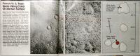
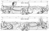
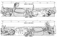
Posted by: PDP8E Dec 10 2006, 12:45 AM
Found these informative sketches on:
http://history.nasa.gov/SP-425/contents.htm
(scroll to bottom and see Panoramic Sketches)
they give the all important (to me at least) "North South East West" markers on the Viking Pans so that you can compare them to the HIRISE
enjoy
~ pdp8
|
|
Posted by: As old as Voyager Jan 28 2007, 04:20 PM
Is it possible that UV radiation or weathering is breaking down some material present on the Viking landers?
Viking 1 as seen by HiRISE has a light trail eminating vertically from the lander:
http://hiroc.lpl.arizona.edu//images/PSP/PSP_001521_2025/PSP_001521_2025_RED_VL-1_lander.png
Viking 2 from HiRISE also has a similar streak stretching to the lander's left:
http://hiroc.lpl.arizona.edu//images/PSP/PSP_001501_2280/PSP_001501_2280_RED_VL-2_lander.png
The light streaks may simply be due to deposits of lighter material built up by the wind as it interacts with the landers. However the large boulder 'Big Joe', seen just to Viking 1's upper right, doesn't sport such a light streak.
Could the light material be something stripped off the landers due to their prolonged exposure on the Martian surface?
Posted by: djellison Jan 28 2007, 04:46 PM
Perhaps the interaction of the rockets during landing - not sure how much or for how long it would make an impact on the ground though.
Doug
Posted by: Phil Stooke Jan 28 2007, 09:23 PM
I see the streaks you mean, but I don't think they are very significant. Almost anywhere you put a lander on these complex surfaces, some sort of marking might appear to be associated with the spacecraft. Pick a random nearby spot and see if it also has a streak.
Phil
Powered by Invision Power Board (http://www.invisionboard.com)
© Invision Power Services (http://www.invisionpower.com)