Viking 1 & 2 landers from HiRISE, Landers definitively spotted |

  |
Viking 1 & 2 landers from HiRISE, Landers definitively spotted |
 Dec 4 2006, 11:19 PM Dec 4 2006, 11:19 PM
Post
#1
|
|
 Administrator  Group: Admin Posts: 5172 Joined: 4-August 05 From: Pasadena, CA, USA, Earth Member No.: 454 |
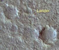
Thought I'd start a new topic for the HiRISE images of the Viking 1 and 2 landers:
Viking 1 Viking 2 --Emily -------------------- My website - My Patreon - @elakdawalla on Twitter - Please support unmannedspaceflight.com by donating here.
|
 |
 
|
|
Dec 4 2006, 11:23 PM
Post
#2
|
|||
|
Administrator Group: Admin Posts: 5172 Joined: 4-August 05 From: Pasadena, CA, USA, Earth Member No.: 454 |
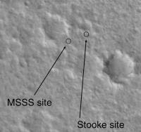
I want to congratulate Phil Stooke for his right-on location of the Viking 1 lander site:
HiRISE location:
MSSS and Phil's locations:
--Emily -------------------- My website - My Patreon - @elakdawalla on Twitter - Please support unmannedspaceflight.com by donating here.
|
||
|
|
|
||
|
Dec 4 2006, 11:34 PM
Post
#3
|
||
|
Administrator Group: Admin Posts: 5172 Joined: 4-August 05 From: Pasadena, CA, USA, Earth Member No.: 454 |
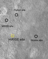
...and it looks like nobody got the Viking 2 site. Here's Phil's map, with the actual location circled. There is a spot in the MOC image that can be identified as the lander, with the benefit of the HiRISE location.
--Emily -------------------- My website - My Patreon - @elakdawalla on Twitter - Please support unmannedspaceflight.com by donating here.
|
|
|
|
|
|
|
Dec 4 2006, 11:41 PM
Post
#4
|
|
|
Senior Member Group: Members Posts: 1582 Joined: 14-October 05 From: Vermont Member No.: 530 |
Wow. Very impressive stuff. (And an attaboy for Phil)
|
|
|
|
|
Dec 4 2006, 11:41 PM
Post
#5
|
||
|
Member Group: Members Posts: 428 Joined: 21-August 06 From: Northern Virginia Member No.: 1062 |
QUOTE (elakdawalla @ Dec 4 2006, 04:34 PM)  ...and it looks like nobody got the Viking 2 site. Here's Phil's map, with the actual location circled. There is a spot in the MOC image that can be identified as the lander, with the benefit of the HiRISE location.
--Emily I was the first to find the MSSS site, it turns out that is the backshell. |
|
|
|
|
|
|
Dec 4 2006, 11:49 PM
Post
#6
|
|
|
Member Group: Members Posts: 154 Joined: 21-April 05 From: Rochester, New York, USA Member No.: 336 |
What's the scale - how far apart are the different estimates?
|
|
|
|
|
Dec 4 2006, 11:52 PM
Post
#7
|
|
 Senior Member Group: Admin Posts: 4763 Joined: 15-March 05 From: Glendale, AZ Member No.: 197 |
QUOTE (elakdawalla @ Dec 4 2006, 03:23 PM) I want to congratulate Phil Stooke for his right-on location of the Viking 1 lander site: Wow, thanks Emily for digging that up quick! That was the first thing I was going to check for. High fives all around Phil! -------------------- If Occam had heard my theory, things would be very different now.
|
|
|
|
|
Dec 4 2006, 11:55 PM
Post
#8
|
||
|
Founder Group: Chairman Posts: 14432 Joined: 8-February 04 Member No.: 1 |
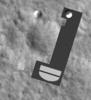
Well - that chute really doesn't need a question mark
 Awesome images! That the chute is at all visible after 30 years is amazing. Awesome images! That the chute is at all visible after 30 years is amazing.Doug
Attached thumbnail(s)
|
|
|
|
|
|
| Guest_AlexBlackwell_* |
Dec 4 2006, 11:56 PM
Post
#9
|
|
Guests |
I'd like to add congrats to Phil, too. I've followed his work, and recall his 1997 paper in Earth, Moon, and Planets.
|
|
|
|
|
Dec 5 2006, 12:11 AM
Post
#10
|
|
 Member Group: Members Posts: 547 Joined: 1-May 06 From: Scotland (Ecosse, Escocia) Member No.: 759 |
Congrats encore. I suppose the Viking 2 chute must be there too, just twisted up and covered with dust, and therefore well camouflaged?
Looking forward to seeing Mars 3 perhaps, and an answer to the failure theory that its TV camera was covered with its own parachute. Kenny |
|
|
|
|
Dec 5 2006, 12:27 AM
Post
#11
|
|
|
Member Group: Senior Member Posts: 136 Joined: 8-August 06 Member No.: 1022 |
QUOTE (djellison @ Dec 4 2006, 03:55 PM) Well - that chute really doesn't need a question mark Awesome images! That the chute is at all visible after 30 years is amazing.Doug Doug: I didn't want to put the question mark on the annotated version, but Alfred preferred it. In the end, there is really no way to be 100.000% certain that it is the parachute, though I think I'm about 99% sure it is  Just a historical self-horn-tooting note: Both the MOC C-PROTO and HiRISE images for the two Viking landers were targeted to those locations based on work I did after the Pathfinder landing, when it was discovered that the Viking-based control net for Mars was imprecise enough that Pathfinder landed 18 kilometers east of where we thought it would. Thankfully, I had plenty of mid to far field topographic features to triangulate to that could be seen even in the 40m/pixel Viking Orbiter images, which were all we had to work with due to the loss of Mars Observer. So many, in fact, that I was able to place the landing site within 12 hours of landing, and with only 60 degrees of the horizon pan down. But, based on this eastward offset from where we expected to land, I started looking at the VL-1 site again. At the same time, Malin's team and the DLR scientists were aware of the discrepency, and approached it from other directions - agreeing that VL-1 (and probably VL-2, though it's location was less precisely known than VL-1) was probably really east of the Viking Team's location by about 6 kilometers. It didn't take long for me to find a better match between the ground and orbiter views for VL-1, because there was a 7m/pixel image from Viking Orbiter to work with. As soon as MOC images were acquired of the "real" location, I poured over them and fine-tuned my location. By the time the MOC C-PROTO was acquired, I knew where the lander would be found to within a few meters, even though the C-PROTO did not reveal the lander. The lander turned out to be within a few meters of my predicted location. VL-2 was a tougher problem, because the topography is so subtle, and because the view to the southwest is largely obscured by the nearby rocky ridge. Phil's technique of vertically exaggerating the horizon helped quite a bit. I used the same technique after compiling a "super resolution" product by co-adding multiple images of the same scene to bring out finer detail and reduce noise. I then triangulated to the various horizon features I could identify, and found a tentative match (plotted in one of the posts above). Ironically, I picked the "wrong" degraded crater west of the lander to correlate the mid-field to. Now that I know where the lander is, if I move my vector plot to that location, I get a good match with the features. Now, I'm eagerly anticipating the HiRISE image of MPF! The more hardware they capture, the more of a feel we'll have for what hardware looks like on the surface of Mars, and the better our chances of locating landers for which we have no ground images - useful for failure analyses. -Tim. |
|
|
|
| Guest_AlexBlackwell_* |
Dec 5 2006, 12:32 AM
Post
#12
|
|
Guests |
QUOTE (tim53 @ Dec 4 2006, 02:27 PM) Now, I'm eagerly anticipating the HiRISE image of MPF! That'll be the money shot, in my opinion. |
|
|
|
|
Dec 5 2006, 12:54 AM
Post
#13
|
|
|
Member Group: Senior Member Posts: 136 Joined: 8-August 06 Member No.: 1022 |
I just saw the press release as it went out.
After it went out, a colleague of mine and I realized that the name for the VL-2 rock "Ankylosaurus" may not have been one used by the Viking team as a whole. I got that name via the late Henry Moore, during the Pathfinder mission, when I was putting together a stereo anaglyph of that rock to understand it's shape better. Apologies if it's not the rock's official designation. -Tim. |
|
|
|
|
Dec 5 2006, 01:20 AM
Post
#14
|
|
|
Solar System Cartographer Group: Members Posts: 10151 Joined: 5-April 05 From: Canada Member No.: 227 |
Tim got the Viking 1 position with a great bit of detective work using the barely adequate Viking images. At the time he did it, people had become convinced that the original identification was wrong. That dated back to about 1980, but when Pathfinder landed not too far away the tracking coordinates and image locations for the two landers together could not be made to match. Pathfinder was not in doubt (another Tim discovery) so Viking had to be wrong.
Mert Davies of RAND calculated a site off to the west from the original estimate (so did others, including, if I recall correctly without going into my files, Tom Duxbury at JPL and Oberst's team at DLR). I think several people were loking in the images for a better site. Mert Davies suggested a specific location to me and I found a crummy match to the panoramas near that location (lesson - you can convince yourself of a bad match quite easily), but he eventually refined his calculations and it moved to a point closer to the location Tim found. Now I'm looking forward to Pathfinder. I think I posted a predicted location recently - just a few MOC pixels off the site MSSS give on their website. Phil -------------------- ... because the Solar System ain't gonna map itself.
Also to be found posting similar content on https://mastodon.social/@PhilStooke Maps for download (free PD: https://upload.wikimedia.org/wikipedia/comm...Cartography.pdf NOTE: everything created by me which I post on UMSF is considered to be in the public domain (NOT CC, public domain) |
|
|
|
| Guest_AlexBlackwell_* |
Dec 5 2006, 01:30 AM
Post
#15
|
|
Guests |
Phil: I haven't checked but do you happen to know how close Morris and Jones [1980] got with their VL1 estimate?
|
|
|
|
|

|
Lo-Fi Version | Time is now: 25th April 2024 - 10:29 AM |
|
RULES AND GUIDELINES Please read the Forum Rules and Guidelines before posting. IMAGE COPYRIGHT |
OPINIONS AND MODERATION Opinions expressed on UnmannedSpaceflight.com are those of the individual posters and do not necessarily reflect the opinions of UnmannedSpaceflight.com or The Planetary Society. The all-volunteer UnmannedSpaceflight.com moderation team is wholly independent of The Planetary Society. The Planetary Society has no influence over decisions made by the UnmannedSpaceflight.com moderators. |
SUPPORT THE FORUM Unmannedspaceflight.com is funded by the Planetary Society. Please consider supporting our work and many other projects by donating to the Society or becoming a member. |
|